• For 2024 Pilgrims: €50,- donation = 1 year with no ads on the forum + 90% off any 2024 Guide. More here.
    (Discount code sent to you by Private Message after your donation)
  • ⚠️ Emergency contact in Spain - Dial 112 and AlertCops app. More on this here.
  • Get your Camino Frances Guidebook here.

Search 69,459 Camino Questions

Google street view

Thengel1

Active Member
Time of past OR future Camino
CF April-May 2013; mid-Sept. 2017
Sometimes I like to look at different places on the camino using Google Street View. you can't go everywhere of course, but it is kind of surprising how many pieces of the camino you can see. Sometimes I am recognize places I stopped for a snack, or just a rest stop, sometimes I remember people I met at a particular spot, sometimes there are pilgrims walking along in the places you are looking at, etc. Anyway, I just like doing it.

Tonight I came across something that stood out in another way. I was looking at the bridge headed into Portomarin. (the one with the steep stairs at the end.) I am guessing the Google car went by at the end of a long, try summer. There are pockets of grass in a couple of places on the river, a little ramp that leads down from a building ends a good 60 metres or so from the water. When I went past there in early May (2013), the water must be a good 6-7 metres deeper. The ramp I mentioned is half underwater, and a dirt road that runs along the far side of the river is completely submerged(well, as far as I tell from my pictures anyway). It is a pretty dramatic difference anyway.

I was vaguely curious if other people had experimented with it much and if they found anything particularly striking.
P1140821.jpg
 
Last edited by a moderator:
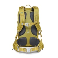
Technical backpack for day trips with backpack cover and internal compartment for the hydration bladder. Ideal daypack for excursions where we need a medium capacity backpack. The back with Air Flow System creates large air channels that will keep our back as cool as possible.

€83,-
Sometimes I like to look at different places on the camino using Google Street View. you can't go everywhere of course, but it is kind of surprising how many pieces of the camino you can see. Sometimes I am recognize places I stopped for a snack, or just a rest stop, sometimes I remember people I met at a particular spot, sometimes there are pilgrims walking along in the places you are looking at, etc. Anyway, I just like doing it.

Tonight I came across something that stood out in another way. I was looking at the bridge headed into Portomarin. (the one with the steep stairs at the end.) I am guessing the Google car went by at the end of a long, try summer. There are pockets of grass in a couple of places on the river, a little ramp that leads down from a building ends a good 60 metres or so from the water. When I went past there in early May (2013), the water must be a good 6-7 metres deeper. The ramp I mentioned is half underwater, and a dirt road that runs along the far side of the river is completely submerged(well, as far as I tell from my pictures anyway). It is a pretty dramatic difference anyway.

I was vaguely curious if other people had experimented with it much and if they found anything particularly striking.

Google Street View is great to have a look round at places on the Camino.

I enjoyed following Google Street View from St Jean all the way till the Camino leaves the road for the last time in France. I didn't walk that stage, getting a lift to the top of the hill before Roncesvalles, but next time I'll give it a go with a stop in Orisson. Following it on the computer though probably took as long or longer than what it would to actually walk it
 
I was vaguely curious if other people had experimented with it much and if they found anything particularly striking.

Any time I go on a trip I use it. I'll walk the route (to the hotel or whatever). It's kind of funny walking in a city you've never been and recognizing all the shops and intersections.
 
The 2024 Camino guides will be coming out little by little. Here is a collection of the ones that are out so far.
Transport luggage-passengers.
From airports to SJPP
Luggage from SJPP to Roncevalles
Sometimes I like to look at different places on the camino using Google Street View. you can't go everywhere of course, but it is kind of surprising how many pieces of the camino you can see. Sometimes I am recognize places I stopped for a snack, or just a rest stop, sometimes I remember people I met at a particular spot, sometimes there are pilgrims walking along in the places you are looking at, etc. Anyway, I just like doing it.

Tonight I came across something that stood out in another way. I was looking at the bridge headed into Portomarin. (the one with the steep stairs at the end.) I am guessing the Google car went by at the end of a long, try summer. There are pockets of grass in a couple of places on the river, a little ramp that leads down from a building ends a good 60 metres or so from the water. When I went past there in early May (2013), the water must be a good 6-7 metres deeper. The ramp I mentioned is half underwater, and a dirt road that runs along the far side of the river is completely submerged(well, as far as I tell from my pictures anyway). It is a pretty dramatic difference anyway.

I was vaguely curious if other people had experimented with it much and if they found anything particularly striking.


Thanks for the idea. I'm going to have a look at the St. Jean to Roncesvalles stretch now. I remember those Portomarin steps. I stood there wondering how the Gods could do this to poor suffering pilgrims at the end of a long hard day! There aren't that many, but enough to make one curse!
 
A good Google street view walk is the one that starts from Roncesvalles and heads towards Pamplona.
That's how I found the river swimming and the hostel with pool at Camping Urrobi.
Next I'm going to walk from Ronces back over the Valcarlos route to St Jean.

Regds
Gerard
 
New Original Camino Gear Designed Especially with The Modern Peregrino In Mind!
"Walking the Camino" on Google Street view is my favorite pastime during lunch hours at work. Then again, it is TORTURE sometimes, specially on days like today when I look out the window and there is a 6 ft pile of snow blocking the view! :). Can't wait to June 2014 when I get to step back on my Camino!!
 
I wonder if Google would give out a Compostela for anyone who follows the last 100km on Streetview... (A Googlestela? Sorry.) I am addicted to Streetview, too
 
New Original Camino Gear Designed Especially with The Modern Peregrino In Mind!
Well tecnology is making things better for pilgrims .

Buen Camino. !
 
I do this all the time! Love to "re-visit" the villages we walked through. Couldn't take a picture of everything while we were walking, so it is nice to see some of the places again using Street View.
 
Ideal sleeping bag liner whether we want to add a thermal plus to our bag, or if we want to use it alone to sleep in shelters or hostels. Thanks to its mummy shape, it adapts perfectly to our body.

€46,-
Google street view is a great way to see what it would be like to
walk the Camino. I did the Camino Frances last spring and spent hours
exploring locations along the route in Google street view before my
trip.

I even created a Google map of locations on the Camino and included
interesting images from 'street view', like people walking, or the
door of an albergue, or a yellow arrow pointing the way.

Here is a link to the map, in case anyone is interested in having a look.

https://www.google.com/maps/ms?msa=...9442942bb22f347&hl=en&ie=UTF8&t=m&z=7&vpsrc=1

Google has modified the street view user interface since I created the
map, so you may need to select "show original map" to see it as it was
intended to be seen; that is, as a set of place markers where each
marker, if clicked on, reveals a google street view image of that
location. To view the location in street view, click on the marker and
then click on the picture that comes up.

Some of the locations I highlighted on the map are useful as well as
entertaining. For example, the location marker entitled "On the upper
road to Roncesvalles" shows people leaving the road (the D428) near
the top of the climb and heading across the fields on their way to the
final descent into Roncesvalles. This is a critical location, although
well signed and not easy to miss.

There are also some mistakes that I only discovered after the fact.
For example, the placemarker for "Palas de Rei" shows people sitting
on the steps of what appears to be a hostel, but, having been there, I
now know that that they are sitting on the steps of a municipal office
building across the street from the hostel. Not a very good hostel, by
the way, and one to be avoided if possible; the washrooms were poor
and the bunk beds rickety. There is, however, a private hostel just
down the side street, past the red Do Not Enter sign, which is
excellent from what I have heard from people who stayed there.

If anyone finds this map useful, or has suggestions for improvement
please let me know, and I'll endeavour to make changes.

If you have problems viewing the map, it may be the browser you are using.
I've only used Safari and Firefox and as of late the user interface is quite different depending on which one I use.
 
I have resorted to Google Maps for identifying the places where I took some pics -my memories of some stages are somewhat blurred, I guess because I was dead tired...
I have been able sometimes to locate even the precise spot on a street where I made the "click". Funny.
 
How does one save the address for your google street map?
 
A selection of Camino Jewellery
This may differ between devices but on a windows laptop/desktop from classic google maps, locate the map or street view that you wish to save.

On the left hand side of the view there is a chain link icon, click on this and it will display a window with a link that you can copy and embed in email, on a post etc. There is also a box that you can click that will shorten the link/URL to a short version which has the same effect, just makes it more manageable.

Below is a view of the Pilgrims Office in Santiago, with the relevant items highlighted.

And here is the link to display it in google maps.

link_icon.jpg


Not sure if this is exactly what you were after but if not post back what you want to do and I'll try and help.
 
Last edited:
Thanks for your response Miguel:) you were most helpful!
 

Most read last week in this forum

One death attributed to a heart attack last week. Two pelegrinos gored, one seriously. One broken leg and many ending in Pamplona due to knee and leg and ankle injuries. Is it possible to confirm...
Hello. I am considering walking the Camino for the first time this fall, probably beginning the third week of September in St. Jean. But I keep reading about how crowded the Camino is, including...
Is there a list of albergues that also have private rooms on the Camino Frances? Gracias.
Hi everyone -- After walking the Frances from SJpdP last October, I'm planning to revisit the bit between Logrono and Burgos this July, following different stages. It's the section where I had...
I started out from Saint-Jean-Pied-de-Port on 1 May. It turned out to be an unforgetable day. Above 1,000 m or so it snowed, catching many people unprepared. Later that day "many" walkers were...
And another attempt looms, to buy a decent Poncho after trying and failing in the previous two likely towns. Anyone know where an Altos or similar might be bought in Leon, please? 😁

❓How to ask a question

How to post a new question on the Camino Forum.

Similar threads

Forum Rules

Forum Rules

Camino Updates on YouTube

Camino Conversations

Most downloaded Resources

This site is run by Ivar at

in Santiago de Compostela.
This site participates in the Amazon Affiliate program, designed to provide a means for Ivar to earn fees by linking to Amazon
Official Camino Passport (Credential) | 2024 Camino Guides
Back
Top