• Remove ads on the forum by becoming a donating member. More here.

Search 74,075 Camino Questions

Gronze offers highly scalable Camino maps for download

The one from Galicia (the round) and the one from Castilla & Leon. Individually numbered and made by the same people that make the ones you see on your walk.
3rd Edition. More content, training & pack guides avoid common mistakes, bed bugs etc
Please add some more information or links so we can find the maps/tracks without having to hunt for them. Where I'm at it's time for my brain to slowly stop working.
goto https://www.gronze.com/gronze-maps and follow the download instructions for IOS and Android.

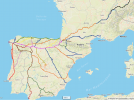
You get an overall Map of all major Caminos, which you can almost indefinitely enlarge to get very detailed route information.
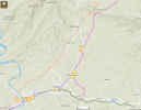
This map would have saved me last year when I chose the wrong path right next to Villavante in the direction to Puente de Orbigo, finally adding some extra 20 km to my day to Astorga, because I used Google maps that sent me to nowhere in the pampa, hahaha.

Screenshot 2023-01-25 at 10.27.54.png

I'll definitely have the Gronze map on my phone next time!
 

Attachments

  • Screenshot 2023-01-25 at 10.15.20.png
    Screenshot 2023-01-25 at 10.15.20.png
    1.8 MB · Views: 71
  • Screenshot 2023-01-25 at 10.16.52.png
    Screenshot 2023-01-25 at 10.16.52.png
    1.6 MB · Views: 60
  • Screenshot 2023-01-25 at 10.17.40.png
    Screenshot 2023-01-25 at 10.17.40.png
    1.5 MB · Views: 110
Last edited:
Perfect memento/gift in a presentation box. Engraving available, 25 character max.
I had a problem with Gronze and it is likely that others may get it also. I submitted something like the following in Spanish and English on a contact form.

I successfully registered with Gronze today but with no password. I have not gotten the email that tells me how to add a password.
 
I would like to know (as I know little about GPS and online mapping etc), if this Gronze mapping is any better or worse than the gps you find on the Buen Camino or Wise Pilgrim apps?

The base map uses Open Street Map data and most likely the Camino apps do too so there shouldn't be a problem there. I'm not certain about tracks and waypoints.
 
It is still a Beta version but entirely functional, available for both, Apple IOS and Android.
(It is all in Spanish but you can open www.gronze.com with Google translate)

Btw: Gronze also has a forum for members (free) without ads and posts reflect Spanish views that can be very interesting
goto https://www.gronze.com/gronze-maps and follow the download instructions for IOS and Android.

Thanks @pepi ....the maps are a great additonal resouce to have on your phone.

The Gronze Forum is new (to me) and very interesting. Some very familiar pilgrims there.
 
Last edited:
...and ship it to Santiago for storage. You pick it up once in Santiago. Service offered by Casa Ivar (we use DHL for transportation).
I had a problem with Gronze and it is likely that others may get it also. I submitted something like the following in Spanish and English on a contact form.

I successfully registered with Gronze today but with no password. I have not gotten the email that tells me how to add a password.
Please note that these maps don't work offline - only while you have a data connection.
This is correct for the current Beta version; it is announced that it will soon be downloadable from the Apple store, and presumable also for Android.
 
A selection of Camino Jewellery
The base map uses Open Street Map data and most likely the Camino apps do too so there shouldn't be a problem there. I'm not certain about tracks and waypoints.
Thanks. I think until I read something that makes these maps better than what I have with WIse Pilgrim or Buen Camino I will stick with what I know. One thing I also like about Gronze.com is when I enter a town and am looking for my albergue (if it is not on the camino) I can go to the page on Gronze that has information on the albergue and click on "Open Map" and it takes me to google maps and I just hit start and I can get to the albergue really easily. Who needs to be searching around after a long day.
 
This is correct for the current Beta version; it is announced that it will soon be downloadable from the Apple store, and presumable also for Android.
It is already on the Google Play store for Android, but this beta version needs an internet connection.

Their site says

Esta primera versión de la App solo funciona con conexión a Internet. Si temporalmente falla la conexión, se indicará con un mensaje "Sin Red" hasta que vuelva a estar disponible.

Translation

This first version of the App only works with an Internet connection. If the connection temporarily fails, it will be indicated by a "No Network" message until it becomes available again.
 
...and ship it to Santiago for storage. You pick it up once in Santiago. Service offered by Casa Ivar (we use DHL for transportation).
I was able to download the app on my Android but cannot access it because I don't have a password nor any instructions on how to create one (yet).
I had the same trouble
 
[I can] click on "Open Map" and it takes me to google maps and I just hit start and I can get to the albergue really easily. Who needs to be searching around after a long day.

On the Caminos Catalan and Aragonese I had Gronze's stage in a browser tab, followed a track with Wikiloc and occasionally used OsmAnd for a wider view (so as not to risk anything with Wikiloc while using it.) When approaching a town I would use Google Maps to see if there was anything interesting that would be out of my sight while walking the camino. I didn't use it for navigation because it isn't very good for displaying trails.
 
As far as I know you first have to open an account on gronze.com an only then you can use the maps. So did I and didnt'have any problem to use the maps.
 
3rd Edition. More content, training & pack guides avoid common mistakes, bed bugs etc
The 2024 Camino guides will be coming out little by little. Here is a collection of the ones that are out so far.
Would this be the best map to follow while walking the Frances, or is there another map app that is better please?
I've not used any of the specialized camino apps but I can say that, at this time, one of the specialized apps would be better. This is because the current version of the Gronze app has to use cellular data and this means money out of your pocket. It may be that they will have a downloadable map by the time you walk. In any case at night when you may have free wifi available you could check the Gronze app against your camino app of choice.
 
Would this be the best map to follow while walking the Frances, or is there another map app that is better please? Guessing the maps once downloaded to your phone, can be used off line? Ist time solo camino person, and worried about getting lost lol
I use both the Buen Camino app and the Wise Pilgrim app. They both have GPS maps that work offline while you are walking - something that Gronze app does not yet do.
 
I had a problem with Gronze and it is likely that others may get it also. I submitted something like the following in Spanish and English on a contact form.

I successfully registered with Gronze today but with no password. I have not gotten the email that tells me how to add a password.
I joined some time ago but I don't recall any problem.
 
A selection of Camino Jewellery
Would this be the best map to follow while walking the Frances, or is there another map app that is better please? Guessing the maps once downloaded to your phone, can be used off line? Ist time solo camino person, and worried about getting lost lol
Depends on where you walk from and when but if it is the Camino Frances then you won't get lost and when you do it is fun and part of the adventure. And I do recognise that I have said both that you won't get lost and that you might get lost.

Really, it is so well marked and there are usually so many other pilgrims that it is not a problem and I would seriously recommend that you don't walk along with your head in your phone, looking at a map, because then you will miss the magic of the Camino.
Thanks very much. I hope not. Ill hold you to it, and youll be the 1st to know if I do lol. I dont use my phone when away, but wanted to know which map I could rely on if I do get lost, walking the Frances. Cheers
 
...and ship it to Santiago for storage. You pick it up once in Santiago. Service offered by Casa Ivar (we use DHL for transportation).
goto https://www.gronze.com/gronze-maps and follow the download instructions for IOS and Android.

You get an overall Map of all major Caminos, which you can almost indefinitely enlarge to get very detailed route information.
This map would have saved me last year when I chose the wrong path right next to Villavante in the direction to Puente de Orbigo, finally adding some extra 20 km to my day to Astorga, because I used Google maps that sent me to nowhere in the pampa, hahaha.

View attachment 140273

I'll definitely have the Gronze map on my phone next time!
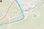
The part that you have marked as 'actual' is no longer the camino because of the dangerous rail crossing at the end. The 'sponsored' route goes over the track.

I use dangerous as a relative term, most people would be able to detect an approaching train.... though they do move pretty quick along this stretch.
Thanks, @wisepilgrim. Yes, this is correct, but as you say, the danger with the railway crossing is relative; the corrosion of the single track indicates, that it is not in use for a long time and that a crossing with the necessary caution is therefore more than "relative".
 
Would this be the best map to follow while walking the Frances, or is there another map app that is better please? Guessing the maps once downloaded to your phone, can be used off line? Ist time solo camino person, and worried about getting lost lol
People have mentioned the Wise Pilgrim and Buen Camino apps, but so far no-one has mentioned my favourite, the app for Mapy.cz . When you select the outdoor map option you can see not only the caminos, but also other long distance paths that may cross over, join temporarily, or be nearby. It's also pretty good for variants, as I discovered recently when joining the Frances from the Madrid. I was able to follow the lesser known route from Melgar cross-country to Bercianos and bypass Sahagun altogether. The only place where I found a discrepancy was in Ponferrada: the waymarked route now (very sensibly) takes the path alongside the Rio Sil. Mapy is still showing the old one that veers further east up to the Avenida de la Libertad. A very minor issue!
I believe you can download 6 maps for free (although I have downloaded more than that now I think?) and then just view your position via GPS without using data. The potential negative is it doesn't have those little Monopoly house-type icons to indicate possible accommodation. But that's Too Much Information for me anyway.
The great advantage is that I'm still using Mapy back home on local paths/routes. Also it's a great Sat Nav and recently helped me drive in and out of a part of NW London I was unfamiliar with. Actually for driving you don't even need to put the screen up, as the voice gives clear instructions on its own...
 
The focus is on reducing the risk of failure through being well prepared. 2nd ed.
The part that you have marked as 'actual' is no longer the camino because of the dangerous rail crossing at the end. The 'sponsored' route goes over the track.

I use dangerous as a relative term, most people would be able to detect an approaching train.... though they do move pretty quick along this stretch.
Thats what Im wooried about
 
I would seriously recommend that you don't walk along with your head in your phone, looking at a map, because then you will miss the magic of the Camino.

That's why I like the Wikiloc app on the camino. Set it to notify you when you walk off track, load the track and go. It saved me some walking a few times (Me: "Gee, I don't see any arrows, that looks more like a driveway than a road, I'll stay on the road that I'm already on." Wikiloc: Squawks.) Useful in cities too where in my experience arrows are harder to see.
 
Last edited:
That's why I like the Wikiloc app on the camino. Set it to notify you when you walk off track, load the track and go. It saved me some walking a few times (Me: "Gee, I don't see any arrows, that looks more like a driveway than a road, I'll stay on the road I'm already on." Wikiloc: Squaks.) Useful in coties too where in my experience arrows are harder to see.
Im going to dowoad And take a look thanks. So it works offline from location does it?
 
The focus is on reducing the risk of failure through being well prepared. 2nd ed.
Im going to dowoad And take a look thanks. So it works offline from location does it?
As repeatedly indicated, the app is still Beta and can not be downloaded from the App Store yet.
As OP I merely wanted to share the news as I – like many peregrinos – much appreciate Gronze's work for the benefit of the Camino world (which is free and without ads btw.)
 
On the Caminos Catalan and Aragonese I had Gronze's stage in a browser tab, followed a track with Wikiloc and occasionally used OsmAnd for a wider view (so as not to risk anything with Wikiloc while using it.) When approaching a town I would use Google Maps to see if there was anything interesting that would be out of my sight while walking the camino. I didn't use it for navigation because it isn't very good for displaying trails.
When I walk I try to use apps and my phone as little as possible. I will open Buen Camino to the GPS if that little camino birdie in my head tells me I probably spaced and am going the wrong way. Otherwise (can't say about the Catalan) most caminos are really well marked that I have walked on. You will be doing the VDLP which is super easy. Just walk straight and walk North and you can't really go wrong!!!! I do not see alot of sights that people may detour for or spend time at as I want to make my life simple and my brain blank. If I am spending a rest day somewhere or something that may be really spectacular like San Juan de la Pena. It also seems like whenever I open my GPS to see if I made a boo boo I end up making a boo boo or tripping or stepping in an ankle deep puddle because I am looking at that damn app instead of walking.
 
People have mentioned the Wise Pilgrim and Buen Camino apps, but so far no-one has mentioned my favourite, the app for Mapy.cz
Yes, I love the mapy.cz app, and use it quite a bit, but Buen Camino is my favorite for the Camino.
As repeatedly indicated, the app is still Beta and can not be downloaded from the App Store yet.
It's available in the Google Play store for Android - I have downloaded it.
like many peregrinos – much appreciate Gronze's work for the benefit of the Camino world (which is free and without ads btw.)
I agree. Gronze is a great resource, which I use a lot.
 
A selection of Camino Jewellery

❓How to ask a question

How to post a new question on the Camino Forum.

Most read last week in this forum

Anyone had ever encountered any trouble ot unjust behavior from Hospitaleros? If so, what was it and what to do??
I am not a fan of the Camino Francés, I have never walked it and most probabaly never will. (Please don't discuss the pros/cons of this route on this thread). However, despite my strong opinions...
I AM A PLANNER... I was 10 days in on my last camino before I was able to "relax" - that was when I finally had all of my nights booked. Please, do not make this a discussion about "to book or...
Not sure if this is appropriate use of the forum - but I just completed the Camino Frances last week (yay!!!) and bought a souvenir jet/silver ring for myself in Santiago, and the the jet stone...
My wife and I will finish our third camino next June in Santiago de Compostela. We will have approximately a week before we need to be in Lisbon. We are looking for advice for interesting places...

Featured threads

❓How to ask a question

How to post a new question on the Camino Forum.

Featured threads

Forum Rules

Forum Rules

Camino Updates on YouTube

Camino Conversations

Most downloaded Resources

This site is run by Ivar at

in Santiago de Compostela.
This site participates in the Amazon Affiliate program, designed to provide a means for Ivar to earn fees by linking to Amazon
Official Camino Passport (Credential) | 2024 Camino Guides
Back
Top