• ⚠️ Emergency contact in Spain - Dial 112 and AlertCops app. More on this here.
  • Remove ads on the forum by becoming a donating member. More here.

Search 74,075 Camino Questions

Martigny to Sembrancher

Pilgrim 122

Active Member
Time of past OR future Camino
currently walking Rome to Santiago
I am walking from London to Rome in stages. The next section is from Lausanne and over the St Bernard Pass. My guide book by Alison Raju advises the section between Martigny and Sembrancher is the worst section of the whole VF as the path is very narrow with steep sided cliffs above a river. I am walking alone. I would like to walk if I can but don't want to take unnecessary risks . I read a few blogs where people have taken the train for this section instead which I could do. I wondered if anyone has walked this bit and if so what it was like?
thanks
 
The 2024 Camino guides will be coming out little by little. Here is a collection of the ones that are out so far.
I am walking from London to Rome in stages. The next section is from Lausanne and over the St Bernard Pass. My guide book by Alison Raju advises the section between Martigny and Sembrancher is the worst section of the whole VF as the path is very narrow with steep sided cliffs above a river. I am walking alone. I would like to walk if I can but don't want to take unnecessary risks . I read a few blogs where people have taken the train for this section instead which I could do. I wondered if anyone has walked this bit and if so what it was like?
thanks
I read that section right on the morning that I took the route last year....I hadn't read it before setting out: oops! It is very hard to advise other people about how difficult a section is, but I can tell you what I did. I continued, even though I do not like heights very much. I would say the first section, to Sembrancher was hard work, because steep in parts, but not as difficult as implied in the book, and I never found it vertiginous.
In fact the route has changed in several places from that given in the book. It is well waymarked and signposted. The bit where I think it says you have to hang on to chains as you walk along(?) is no longer there and there is a completely new bridge at one point. I walked alone. You can indeed take the train, and the Raju book tells you not to use the road as an alternative. If I were going again, I would take the waymarked path (different in some details from Alison Raju's route) again. From Sembrancher on to Orsieres there was no problem.
 
I am walking from London to Rome in stages. The next section is from Lausanne and over the St Bernard Pass. My guide book by Alison Raju advises the section between Martigny and Sembrancher is the worst section of the whole VF as the path is very narrow with steep sided cliffs above a river. I am walking alone. I would like to walk if I can but don't want to take unnecessary risks . I read a few blogs where people have taken the train for this section instead which I could do. I wondered if anyone has walked this bit and if so what it was like?
thanks
I walked the full VF (London to Rome) in one go solo from March to June this year. Your post doesn't mention what month you'll walk this stage but as you intend to cross St Bernard Pass, I'm assuming it'll be the summer months whereas I (& @timr although a different year) walked very early Spring.
I reached the Martigny-Sembrancher 'dilemma' at the beginning of May. I have a balance disorder (not a fear of heights) which hugely impacts my walking where any kind of path with a drop-off, a narrow path, rock-hopping, tree roots, stream fording, etc is involved. I elected to take the train even knowing Alison Raju's guidebook description was out of date. I was glad I did as I saw winter damage along that section. The guidebook stated no problems from Sembrancher but that was not the case for me. Being so early in the 'walking season', I encountered snow, mud, rockfalls, streams & downed trees. Also the path was narrow with drop-offs in places which made the going very challenging for my circumstances. Although I'll never know for sure, based on what I saw from the train window & experienced after, I feel I would have encountered similar issues/conditions on the Martigny-Sembrancher section.
My suggestion if unsure is make the call at the time depending on when you're walking, the weather, your experience level & knowledge of your own abilities/limitations. If none of the above are issues, @timr 's advice is always rock solid.
Happy trails!
👣 🌏
 
Last edited:
3rd Edition. More content, training & pack guides avoid common mistakes, bed bugs etc
I did this section in late May this year in nice clear weather. I didn’t read my Lightfoot guide until after my walk and not sure what I would have done if I had. There were a few areas washed out from winter and it was a difficult day and I was glad for the ropes and wires in spots and for my hiking poles. The guide mentioned an alternate route that was more roads and trails that might have been easier. When I got to Orsieres and was asked how the trail was, they didn’t seem surprised by the washouts and implied that they would be repaired before it got busier in June-July. Beautiful scenery the whole day!
 
Thank you all for your replies. I am going late August, I had also read about the chains to hang onto which sound a bit alarming! I will take all your advice and probably see how I feel on the day and what the weather is like, I have the official VF route GPX trace on my phone so would follow that and the waymarks. I appreciate all your help.
 
Thank you all for your replies. I am going late August, I had also read about the chains to hang onto which sound a bit alarming! I will take all your advice and probably see how I feel on the day and what the weather is like, I have the official VF route GPX trace on my phone so would follow that and the waymarks. I appreciate all your help.
Yes, as @kazrobbo points out weather is a significant factor to be taken into account. Wet weather can make a pleasant if testing track almost impossible, as I found out recently several times, walking in Albania. Although, somewhat spookily, whenever I decided that the way was QUITE impossible an octogenarian shepherd would appear guiding a flock of sheep and goats, without the benefit of lightweight gear or a GPS, with a cheery wave. Horses for courses.
I did this section in late May this year in nice clear weather. I didn’t read my Lightfoot guide until after my walk and not sure what I would have done if I had. There were a few areas washed out from winter and it was a difficult day and I was glad for the ropes and wires in spots and for my hiking poles. The guide mentioned an alternate route that was more roads and trails that might have been easier. When I got to Orsieres and was asked how the trail was, they didn’t seem surprised by the washouts and implied that they would be repaired before it got busier in June-July. Beautiful scenery the whole day!
I am interested to hear that there is active repair of the path. That sounds rather Swiss, and I mean that as a compliment.
There were two nicely strange things about the section. Every so often the cheery train would pass by on the right, the 'St Bernard Express' and in the first section there were those 'open air gym' apparatuses, made of solid timber, along the way.

On that stage from Martigny to Sembrancher, the 'green book', (Vol 1) in the Italian Terre di Mezzo series, by Riccardo Latini, says:
Il sentiero segnato VFN 70, che conduce a Sembrancher, è senza'altro il tratto più difficile di tutta la VF: richiede esperienza e passo fermo per alcuni tratti esposti sulla valle e che in caso di pioggia anche recente diventa molto scivoloso e può essere soggetto a frane. Assicuratevi che il sentiero sia percorribile e comunque utilizzatelo solo nelle giornate di bel tempo.
Tr: The path marked VFN 70 to Sembrancher is quite definitely the most difficult stretch of the whole VF. It requires experience and a steady step for some of the exposed sections in the valley. When it is raining, or after recent rain it can become very slippery and there can be landslides. Assure yourself that the path is passable and only use it in good weather.

I think that sounds fair. That book is 2011 and again I think the details of the route have changed since, and almost certainly in the direction of making it easier. But the point that the weather is significant is worth stressing. The day I walked (early May 2018) it was VERY hot, but there was still some snow remaining from avalanches.

This link is strange......it is a Swiss tourism link and describes the path as Grade / Fitness Level - Easy (hiking trail / Difficult. I am not quite sure how to interpret that. Does it mean it is easy while on the hiking trail and then gets difficult? Anyway there are very nice photos of the trail on that site.
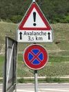
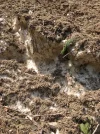
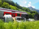
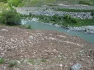
My photos show a permanent(!) avalanche warning sign, an avalanche I walked over, the tempting train, and a view over the avalanche down to the river.

IMG_5562.webpIMG_5563.webpP5120513.webpP5120530.webp
 
Perfect memento/gift in a presentation box. Engraving available, 25 character max.
I walked this part end of september and there was a sign on the trail that said that the bridge was not there anymore. So I walked on the road. There was no snow and it was easy to walk, enough space for me and the trucks on the road. Train was never an option for me as I wanted to walk every single step from my home to Rome.
 
I am not familiar with this way but my Swiss ancestors came from Sembrancher 150 years ago. I still have relatives there.
 
The 2024 Camino guides will be coming out little by little. Here is a collection of the ones that are out so far.
If you can see a copy of the Swiss 1:50000 T series map (282T covers Martigny) it will have the hiking routes marked in red. If the line is solid red (Wanderweg) there should be no problems. If it is a dashed red line, this is a (bergweg) and might prove more challenging. I only have an old (non T series) map that does not help. Stanfords in London should have a copy of 282T
 
If you can see a copy of the Swiss 1:50000 T series map (282T covers Martigny) it will have the hiking routes marked in red. If the line is solid red (Wanderweg) there should be no problems. If it is a dashed red line, this is a (bergweg) and might prove more challenging. I only have an old (non T series) map that does not help. Stanfords in London should have a copy of 282T
Just in case anyone is a regular (but not very often) visitor to Stanford's in Long Acre, be aware that although it had been there since 1901 it has recently moved just a few hundred yards/metres around the corner to Mercer Walk/Langley Street. I was very surprised last week! It moved just in January.
(Stanford's is a venerable map and travel book shop in London, for those who may not have heard of it.)
 
You can look at (and printout) the official Swiss topographical map. You can also select (under Open Menu) and print the section you are interested in with a scale of 1:25,000 or 1:50,000. (In the Menu you'll also find a Maps Displayed option. You can choose to display the official hiking trails.)
I haven't walked this section, and I haven't looked at the official VF route, but from looking at these maps (and if you are comfortable reading a map) there are plenty of safe alternative routes over the mountain from Martigny to Sembrancher. You don't have to choose the route that is questionable. For example, for the section above Les Trappistes, you can choose to go over the steep rocks and scree, or you can go along the solid black line trail.
 
Last edited:
Ideal sleeping bag liner whether we want to add a thermal plus to our bag, or if we want to use it alone to sleep in shelters or hostels. Thanks to its mummy shape, it adapts perfectly to our body.

€46,-
You can look at (and printout) the official Swiss topographical map. You can also select (under Open Menu) and print the section you are interested in with a scale of 1:25,000 or 1:50,000. (In the Menu you'll also find a Maps Displayed option. You can choose to display the official hiking trails.)
I haven't walked this section, and I haven't looked at the official VF route, but from looking at these maps (and if you are comfortable reading a map) there are plenty of safe alternative routes over the mountain from Martigny to Sembrancher. You don't have to choose the route that is questionable. For example, for the section above Les Trappistes, you can choose to go over the steep rocks and scree, or you can go along the solid black line trail.
What a fabulous map!! I can see the afternoon being wasted here. I was able to import my own track and see it superimposed on the map.
This is a great resource. Thanks. T
 
Thank you for pointing out the Swiss Geoportal. However the red wlking routes do not distinguish between the Wanderwegs and Bergwegs. The wanderwegs should have no safety issues. On the ground wanderwegs have plain yellow signposts. Bergwegs have red and white markers.
 
You can look at (and printout) the official Swiss topographical map. You can also select (under Open Menu) and print the section you are interested in with a scale of 1:25,000 or 1:50,000. (In the Menu you'll also find a Maps Displayed option. You can choose to display the official hiking trails.)
I haven't walked this section, and I haven't looked at the official VF route, but from looking at these maps (and if you are comfortable reading a map) there are plenty of safe alternative routes over the mountain from Martigny to Sembrancher. You don't have to choose the route that is questionable. For example, for the section above Les Trappistes, you can choose to go over the steep rocks and scree, or you can go along the solid black line trail.
This
You can look at (and printout) the official Swiss topographical map. You can also select (under Open Menu) and print the section you are interested in with a scale of 1:25,000 or 1:50,000. (In the Menu you'll also find a Maps Displayed option. You can choose to display the official hiking trails.)
I haven't walked this section, and I haven't looked at the official VF route, but from looking at these maps (and if you are comfortable reading a map) there are plenty of safe alternative routes over the mountain from Martigny to Sembrancher. You don't have to choose the route that is questionable. For example, for the section above Les Trappistes, you can choose to go over the steep rocks and scree, or you can go along the solid black line trail.
If you can see a copy of the Swiss 1:50000 T series map (282T covers Martigny) it will have the hiking routes marked in red. If the line is solid red (Wanderweg) there should be no problems. If it is a dashed red line, this is a (bergweg) and might prove more challenging. I only have an old (non T series) map that does not help. Stanfords in London should have a copy of 282T
Thank you this is very helpful. I wonder if anyone has walked this alternative route ?
 
The focus is on reducing the risk of failure through being well prepared. 2nd ed.
I walked the full VF (London to Rome) in one go solo from March to June this year. Your post doesn't mention what month you'll walk this stage but as you intend to cross St Bernard Pass, I'm assuming it'll be the summer months whereas I (& @timr although a different year) walked very early Spring.
I reached the Martigny-Sembrancher 'dilemma' at the beginning of May. I have a balance disorder (not a fear of heights) which hugely impacts my walking where any kind of path with a drop-off, a narrow path, rock-hopping, tree roots, stream fording, etc is involved. I elected to take the train even knowing Alison Raju's guidebook description was out of date. I was glad I did as I saw winter damage along that section. The guidebook stated no problems from Sembrancher but that was not the case for me. Being so early in the 'walking season', I encountered snow, mud, rockfalls, streams & downed trees. Also the path was narrow with drop-offs in places which made the going very challenging for my circumstances. Although I'll never know for sure, based on what I saw from the train window & experienced after, I feel I would have encountered similar issues/conditions on the Martigny-Sembrancher section.
My suggestion if unsure is make the call at the time depending on when you're walking, the weather, your experience level & knowledge of your own abilities/limitations. If none of the above are issues, @timr 's advice is always rock solid.
Happy trails!
👣 🌏
Hello, I thought that the VF started in Canterbury, England; is this true? Or does it start in London and if so, where in London? Is there a trail or does one walk on the road from London?
 
@Kelly Ann Welcome to the forum. The 'classical' VF I suppose is from Canterbury to Rome - that is where I walked. Sigeric was the Archbishop of Canterbury when he walked from Canterbury to Rome (and back). There are a number of (pre-)extensions and people walk for example from London - either from St Paul's or Southwark Cathedral. Other people start from Winchester (once the capital) and there is a waymarked path from there to Canterbury. Other people walk from their front door, or perhaps from another pilgrimage site, like Iona.
But as I said, the classical way as described is from Canterbury, and there is a 0km marker stone there!
Thank you, Timr. Thank you so much for explaining. I'm curious as I hope to do a longer Camino. Okay. So I know where St Paul's is sounds like you got to walk on the road from there but you say there's a waymarked path from Winchester? That's very good to know!
 
Perfect memento/gift in a presentation box. Engraving available, 25 character max.
Thank you, Timr. Thank you so much for explaining. I'm curious as I hope to do a longer Camino. Okay. So I know where St Paul's is sounds like you got to walk on the road from there but you say there's a waymarked path from Winchester? That's very good to know!
For London to Canterbury see here:
And from Winchester see this:
I am all for long walks - I am on the way to Jerusalelm at present, but not all in one go!
But you will find MOST people walk from Canterbury. Good luck with your planning.
Another thing you need to keep in mind, if you are planning is timing, if you wish to walk across the Great St Bernard Pass. My notes on that here.
You should find this forum very good for advice - people are very friendly and willing to share experience.
It is worth starting a new thread if you have a specific question, as you are more likely to get a reply that way. ;)
 
Hello, I thought that the VF started in Canterbury, England; is this true? Or does it start in London and if so, where in London? Is there a trail or does one walk on the road from London?
The VF does officially start in Canterbury. However I started in London from Southwark Cathedral & combined the Pilgrims Way to Canterbury (PWC) with the VF thus giving me a path from London to Rome...a total distance (for me) of 2118km.

The PWC basically follows the North Downs Way although not entirely. If you are considering this an extension, I'll warn you the first few days aren't pretty (or fun) as they're spent escaping the sprawl that is Greater London. I chose to add the PWC to the VF for an additional challenge but mainly used it to 'walk myself in' & iron out any kinks before tackling the long haul to Rome.
For me actually walking to Canterbury gave the start of the VF more meaning. With the benefit of hindsight, I would do the same again.
Although a lot of people break long walks into stages (sometimes over years) that's not for me. If I can't do it in one hit, I don't want to do it all. The cumulative effect of spending so much time, energy & effort plus dealing with all the issues (positive & negative) of the trail is what makes these long distance walks so extraordinary. Start/stop/restart just wouldn't be the same although I understand why people want/need to do it this way.
Feel free to contact me if you have any queries.
Happy trails!
👣 🌏
 
Last edited:
But you will find MOST people walk from Canterbury. Good luck with your planning.
You should find this forum very good for advice - people are very friendly and willing to share experience.
It is worth starting a new thread if you have a specific question, as you are more likely to get a reply that way. ;)
Clearly I am not MOST people! 😄
👣 🌏
 
Ideal sleeping bag liner whether we want to add a thermal plus to our bag, or if we want to use it alone to sleep in shelters or hostels. Thanks to its mummy shape, it adapts perfectly to our body.

€46,-

❓How to ask a question

How to post a new question on the Camino Forum.

Most read last week in this forum

I went into the official website, but it said there was no way that a credential could be shipped to my home address. It does look like we would be able to get credentials in Lucca where we will...
Greetings, We are flying into London this April and contemplating starting the Via Francigena from Southwark Cathedral. We will break the journey into four or five phases, with the first segment...

Featured threads

❓How to ask a question

How to post a new question on the Camino Forum.

Featured threads

Forum Rules

Forum Rules

Camino Updates on YouTube

Camino Conversations

Most downloaded Resources

This site is run by Ivar at

in Santiago de Compostela.
This site participates in the Amazon Affiliate program, designed to provide a means for Ivar to earn fees by linking to Amazon
Official Camino Passport (Credential) | 2024 Camino Guides
Back
Top