- Nov 1, 2008
- 11,024
- 23,255
- 71
- Time of past OR future Camino
- 2006 to date: Over 21 Caminos. See signature line
I stuck to the old one, force of habit I guess ;-) Buen Camino, SY

I think that's the route I took. Don't remember exactly. All I know is that it was a different route than I took before into Portomarin, and I believe it was to the left of the other route and I ended up on the road a short distance from the bridge, to the left.Oh I know where you mean now.... Yes it is steep and rocky but it is very short.
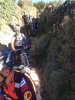
Sorry about the ghastly pic, just look at the path
Just came into Portomarin an hour ago. Did the Camino Frances in 2013.
The 2013 route went east and hit the road to east of the bridge. You crossed on the right side of the bridge, with a great view of the old Roman bridge below you, at least when the water level was low, as it was in 2013.
The new route hits the road west of the bridge. As you approach the bridge you can see the old Roman bridge. You cross on the left side of the new bridge and, at least with today's low water, get a great view of the Roman ruins from the old town.
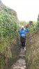
The new route gives you a choice. You can stay on the road, more or less straight or turn right and go down the trail. There are two stone Camino stone markers, offering contradicting guidance. There is a sign, clearly stating in several languages, one of which is English, that the trail includes a dangerous pedestrian passage.
The trail is great until the last descent to the road, which is very steep and rocky. This 68 year old had no trouble with it, but I started in Le Puy and the Aubrac gave me pretty good training. If I do it again, I'll take the same trail unless it is raining.
At the same time, I must admit that this 68 year old is, it has to be said, slow on the descents; I created a bottle neck of at least 15 pilgrims, including two bikers (!).
From where you hit the fork where the two routes start, to where you come out near the bridge to cross is a short distance. Very small section. I don't recall remember one being more scenic than the other.Awesome!
I reckon I'll give it a try in december.... My last CF was also in 2013
Ultreia!
Yes, that's the one I took. I remember walking behind those houses, almost like an alley way, and wondering if I was on the right path, then I emerged on the road and could see the bridge.My wife and I used the newer variant this year. I don't recall this being marked as an alternative when I walked in 2010, but it appeared from the sign where the paths parted that the old route has become badly eroded and degraded. I remember the old route being a steep descent at the time, but not the specific details of the route surface other than I don't recall it being particularly eroded.
In any case, the new route seemed less steep, followed the road for a while then a track along the back of some houses before emerging onto another road a short distance from the bridge. I don't recall it being particularly difficult.
You walked the old route. They've re-routed the Camino for some reason and nearly everyone I talk to finds the new route hazardous.When did the "new route" come to be? Was it there in the fall of 2013? I don't remember anything that perilous. I do remember coming out of a path on the road near the bridge.
From where you hit the fork where the two routes start, to where you come out near the bridge to cross is a short distance. Very small section. I don't recall remember one being more scenic than the other.
Basically it's six of one, half dozen of the other. I think you will be disappointed if you are looking to mountaineer on it.
Thanks Mark! I guess I'll just flip a coin when the time comes!
And non, I'm not looking into any mountaineering on the Camino Frances at all.. I've been on it enough times to know that there aren't any mountaineering involved in any of the Caminos (At least that I know of). I've just mentioned that "as a mountaineer" I`m usually keen to choose the hardest, longest and more dangerous alternatives as they, usually, provide more scenic alternatives
Ultreia!
it's just a very short, steep, rocky descent. I had forgotten all about it until mentioned...Just came into Portomarin an hour ago. Did the Camino Frances in 2013.
The 2013 route went east and hit the road to east of the bridge. You crossed on the right side of the bridge, with a great view of the old Roman bridge below you, at least when the water level was low, as it was in 2013.
The new route hits the road west of the bridge. As you approach the bridge you can see the old Roman bridge. You cross on the left side of the new bridge and, at least with today's low water, get a great view of the Roman ruins from the old town.
The new route gives you a choice. You can stay on the road, more or less straight or turn right and go down the trail. There are two stone Camino stone markers, offering contradicting guidance. There is a sign, clearly stating in several languages, one of which is English, that the trail includes a dangerous pedestrian passage.
The trail is great until the last descent to the road, which is very steep and rocky. This 68 year old had no trouble with it, but I started in Le Puy and the Aubrac gave me pretty good training. If I do it again, I'll take the same trail unless it is raining.
At the same time, I must admit that this 68 year old is, it has to be said, slow on the descents; I created a bottle neck of at least 15 pilgrims, including two bikers (!).
I would worry if any part of the Camino Frances really went east! I have just checked my 2010 and 2016 GPS tracks, and the old route does go roughly to the NNE for about 100m before heading in a generally NW direction.The 2013 route went east and hit the road to east of the bridge.
It was raining fairly hard when I went down the new route. I missed any signs for the old route. I found this to be the worst experience on the Frances. I went down parts of it on my butt.
This was *the* topic of conversation for most of us in Portomarin, as many found it very challenging and a few people fell or slid. I was wondering why I had not heard of this stretch, and many said that it was that new that the guidebooks didn't mention it.
I would have taken the alternative route if I had known.
Blessings, Priscilla
Kinda embarrassing to admit that I didn't know of another route until reading it here moments ago. Did I mention I donated my Guide book on day 3. I am getting confused. The newer variant comprises a section along the road followed by a trail along the back of some houses and other buildings. At least in Jun this year there was no particularly difficult section. It sounds like you might have taken the shorter and steeper (and older) variant where it appears the track surface has become badly eroded.I did the new....WOW...it was a scary decent.
I am getting confused. The newer variant comprises a section along the road followed by a trail along the back of some houses and other buildings. At least in Jun this year there was no particularly difficult section. It sounds like you might have taken the shorter and steeper (and older) variant where it appears the track surface has become badly eroded.
When I got at the place where two options were apparent, there were many pilgrims around and we were standing around and wondering which option to choose. Then some people said the road to the left is for bicycles, and most people went straight on. I was unwise enough to follow them, even though I had seen people on the camino forum telling about the difficult descent into Portomarin. So I thought a difficult descent was inevitable. As there were lots of people (several groups of "Sarria pilgrims" happened to be there at the same as me) I let everyone pass when it got difficult in order to take my time. I am 62 years old and not an experienced mountaineer and since I was walking alone I was always careful not to take any chances. Even though I had walking poles, there were times that I was afraid to use them and I took them into one hand and steadied myself against the narrow wall of the canyon with the other hand. My Salomon shoes were a size larger (as people recommend) and they fitted perfectly, and my toenails were very short, but I did not realise that my feet were slipping to the front of the shoes - being inexperienced I perhaps did not realise that the shoes' strings might have been too loose going down there (I forgot about that in the heat of the moment). But that is the day that I got two purple toenails. I just hope that the nails will not come off.
Only that evening at dinner I heard that the other route was less difficult. So the lesson learnt is, it is not always wise to follow the group - it might be better to read the notices yourself and make your own desicions! I consider that narrow gorge to be Purgatory and then you enter the lovely, heavenly Portomarin.
Dougfitz, I was there in June this year also. I stopped in Vilacha to ask about the new route. Apparently the OLD route approaching Portomarin's bridge from the right is no longer marked. The new route heads down the road in the opposite direction where it then splits off, to the right and the steepness (it's well marked), and to the left on the main road to the back of those buildings and the nasty trail. We took the trail behind the buildings. This way is now marked as 'complimentery'. It was so nasty and scary that we weren't sure we were in the right place until we happened upon a man working and he told us we were almost there. We popped out onto the main road and approached the bridge from the left.

The old route seemed to be well enough marked last month. My friend Jo hated it though, worst flight of "steps" on the Camino! In 2012 we turned right just after the T junction and had no great problems.
On the photo yellow line is 2012, blue line is 2016.
View attachment 29535
And yes, the woodland has been destroyed.
Ditto. I don't remember any nasty, really steep section. I only remember walking behind those houses and wondering if I was on the right path and then I remember coming out on the road to the left of the bridge.I am getting confused. The newer variant comprises a section along the road followed by a trail along the back of some houses and other buildings. At least in Jun this year there was no particularly difficult section. It sounds like you might have taken the shorter and steeper (and older) variant where it appears the track surface has become badly eroded.
Ditto. I don't remember any nasty, really steep section. I only remember walking behind those houses and wondering if I was on the right path and then I remember coming out on the road to the left of the bridge.
I had a similar experience as far as making a decision which way to go. The group that was gathered around the sign when I was there decided that the other way was for cyclists, and we ended up on the very steep and narrow trail. It was quite busy when I went through.When I got at the place where two options were apparent, there were many pilgrims around and we were standing around and wondering which option to choose. Then some people said the road to the left is for bicycles, and most people went straight on. I was unwise enough to follow them, even though I had seen people on the camino forum telling about the difficult descent into Portomarin. So I thought a difficult descent was inevitable. As there were lots of people (several groups of "Sarria pilgrims" happened to be there at the same as me) I let everyone pass when it got difficult in order to take my time. I am 62 years old and not an experienced mountaineer and since I was walking alone I was always careful not to take any chances. Even though I had walking poles, there were times that I was afraid to use them and I took them into one hand and steadied myself against the narrow wall of the canyon with the other hand. My Salomon shoes were a size larger (as people recommend) and they fitted perfectly, and my toenails were very short, but I did not realise that my feet were slipping to the front of the shoes - being inexperienced I perhaps did not realise that the shoes' strings might have been too loose going down there (I forgot about that in the heat of the moment). But that is the day that I got two purple toenails. I just hope that the nails will not come off.
Only that evening at dinner I heard that the other route was less difficult. So the lesson learnt is, it is not always wise to follow the group - it might be better to read the notices yourself and make your own desicions! I consider that narrow gorge to be Purgatory and then you enter the lovely, heavenly Portomarin.
Ditto. I don't remember any nasty, really steep section. I only remember walking behind those houses and wondering if I was on the right path and then I remember coming out on the road to the left of the bridge.
I have looked at my track in Google Earth, and where the blue track in @Jeff Crawley's post passes the second of two wooded areas and goes straight ahead, the road that I took veers to the left and heads in a westerly direction until it reaches a track that heads north to the east of the buildings along the lakeside road. (I think Jeff's map is oriented with the top slightly west of north.) I remember looking back up along the blue alternative where it joins the road again, and thinking that it looked like a pretty nasty descent, and that I was glad my wife and I had not tried to follow it.Mark, you don't remember any nasty steep section because you took the easier way behind the buildings and not the nastier newer section that branches off the road. If someone would only add that green line on the map it would become clear there is 3 seperate ways into Portomarin.
Good to hear you chose the “easy “ route. If you read the 2016 posts you’ll see how lucky. Read mine for a totally unbiased account. Ha! ¡Buen Camino!Hiked to Portomarin today in a pouring rain. After studying the three routes on my Mapy.cz app and viewing the huge sign where the trails diverge, and reading the forum shares, we decided on the road on the left. (Left when facing the river before you cross it). It’s plainly visible on the big sign and on Mapy. It was a piece of cake. Gently sloped blacktop all the way to the river road LU-633, wide paved shoulder over to the bridge.
A sign said bicycle route but there were tractors and cars on it as well as walkers In other words it’s a public highway. On the big sign the road is referred to as “complimentary”.
Good to hear you chose the “easy “ route. If you read the 2016 posts you’ll see how lucky. Read mine for a totally unbiased account. Ha! ¡Buen Camino!
That was the route I took in 2016 when I was nursing a bum knee.Hiked to Portomarin today in a pouring rain. After studying the three routes on my Mapy.cz app and viewing the huge sign where the trails diverge, and reading the forum shares, we decided on the road on the left. (Left when facing the river before you cross it). It’s plainly visible on the big sign and on Mapy. It was a piece of cake. Gently sloped blacktop all the way to the river road LU-633, wide paved shoulder over to the bridge.
A sign said bicycle route but there were tractors and cars on it as well as walkers In other words it’s a public highway. On the big sign the road is referred to as “complimentary”.
Thank you for sharing. Below is a photo of the large sign showing the three trails into Portomarín (not two as the thread title suggests). The very rocky part between stone walls on the left and right at the end of the middle trail can be seen in one of the photos on this information board.After studying the three routes on my Mapy.cz app and viewing the huge sign where the trails diverge, and reading the forum shares, we decided on the road on the left. (Left when facing the river before you cross it)

 Being the coward I am, I went back and took the 'newish' path on the south - I turned right when I got back to the sign.