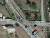
IF google-maps-satellite is up-to-date, a path seems still to be there:
I just pulled it up on Google Earth. The imagery is from 2018. I conclude that the path remains.
Perhaps someone who is there now, or who will be approaching Astorga soon, can verify our assessment?
As an FYI, the RIGHT turn off the Carretera de Leon, heading towards Astorga, onto the side street has a
large red painted panel on the masonry wall for "
Legumbres Ct. Maragato" with a black right-pointing arrow under it. Turn RIGHT onto this side street.
The footpath that goes off to the LEFT is no more than 30 meters from the intersection. The footpath proceeds through the brush (not really a field) directly to the area to the right (North ?) of the blue safety fence. There are no yellow arrows that I can find in the images... But you can plainly see where you want to be.
Once over the track, make a sharp LEFT turn to return to Carretera de Leon. I assess that this detour will take less time, and less effort that the Pilgrim Torture Tower. I am not fond of the up-up-up over then down-down-down... Remember, once you get into Astorga, getting to the albergues and hotels involves a rather steep walk up the steep escarpment the city is built on.
Summing the detour up, coming off the Carretera de Leon, you make a right, followed by a left, walk about 100 meters over the tracks, then make a sharp left to return to the Carretera de Leon.
If you DO try this, Do PLEASE be careful when crossing the tracks...
Hope this helps.


 . . . . . . . . .


