- Time of past OR future Camino
- please see signature
Kia ora (greetings, good health)
Mapped Official route

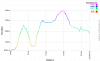
This is VF F47 bis and travels La Cluse-et-Mijoux and on to Les Fourg where it tums south west. An elevation for this route shows a number of steep ascents. One is from 800 metres asl to 1,200 m asl over just a few km. This can be seen in Way Marked Trails. Select Routes in bottom right hand corner and then Via Romea Francigena - Pontarlier to Orbe.
Lightfoot Guide - Besancon to Vercelli of 2014 at pages 48 to 57
This also mirrors the official route to La Cluse-et-Mijoux but on the west side of N57. This route then follows roads and paths after La Cluse. Eventually these are alongside the stream Ruisseau de Fontaine Ronde which in turn meanders beside the N57. After a while the route in the Lightfoot Guide has some alternatives. The maps in the Guide are at too low a resolution to discern details. And I am conscious that a route walked about 10 years ago may no longer be available.
Open Street Maps (OSM) shows this some of this route as an abandoned railway line. A while further on the line of the abandoned railway becomes a railway line restored about 2010: this is now a very popular tourist attraction with a road alongside. From there several maps indicate one can walk to Les Hopitaux-Neufs. And so on to Jounge.
But the OSM detail does not indicate whether this stretch of abandoned can be walked.
I provide the above to show what research I have done, so readers need not repeat it (unless they want to)
QUESTION
Can anyone, please, provide information about whether the Lightfoot route west of N57, and in particular the abandoned railway, can be walked in 2020?
The advantage of taking this route, if it is possible, is avoiding many significant ascents and descents.
Kia kaha (take care, be strong, get going)
Mapped Official route
This is VF F47 bis and travels La Cluse-et-Mijoux and on to Les Fourg where it tums south west. An elevation for this route shows a number of steep ascents. One is from 800 metres asl to 1,200 m asl over just a few km. This can be seen in Way Marked Trails. Select Routes in bottom right hand corner and then Via Romea Francigena - Pontarlier to Orbe.
Lightfoot Guide - Besancon to Vercelli of 2014 at pages 48 to 57
This also mirrors the official route to La Cluse-et-Mijoux but on the west side of N57. This route then follows roads and paths after La Cluse. Eventually these are alongside the stream Ruisseau de Fontaine Ronde which in turn meanders beside the N57. After a while the route in the Lightfoot Guide has some alternatives. The maps in the Guide are at too low a resolution to discern details. And I am conscious that a route walked about 10 years ago may no longer be available.
Open Street Maps (OSM) shows this some of this route as an abandoned railway line. A while further on the line of the abandoned railway becomes a railway line restored about 2010: this is now a very popular tourist attraction with a road alongside. From there several maps indicate one can walk to Les Hopitaux-Neufs. And so on to Jounge.
But the OSM detail does not indicate whether this stretch of abandoned can be walked.
I provide the above to show what research I have done, so readers need not repeat it (unless they want to)
QUESTION
Can anyone, please, provide information about whether the Lightfoot route west of N57, and in particular the abandoned railway, can be walked in 2020?
The advantage of taking this route, if it is possible, is avoiding many significant ascents and descents.
Kia kaha (take care, be strong, get going)


") ) The railway follows part of RU 57. The tourist office says that [the RU57] is very dangerous and very polluted and that they advise the path that follows the old railway. Ph 33 381464833
) The railway follows part of RU 57. The tourist office says that [the RU57] is very dangerous and very polluted and that they advise the path that follows the old railway. Ph 33 381464833