• ⚠️ Emergency contact in Spain - Dial 112 and AlertCops app. More on this here.
  • Remove ads on the forum by becoming a donating member. More here.

Search 74,075 Camino Questions

Which way to go at O Pobo (just north of Redondela)

Time of past OR future Camino
CF: Leon-SdC 2016
CF: SJPD-Leon & CP 2023
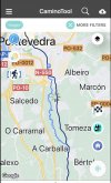
The See the attached picture please. There are 2 waymarks at O Pobo (on the pix, it says A Carballa and has a blue line and a black line). One looks like road walking, the other is a zig zag-does that mean it is up and down or just back-and-forth? Anybody know which is the better route (shorter distance, better scenery)? If you have walked this, please explain what the difference is.
Thanks so much!
Karen
 

Attachments

  • 82CF8CA4-1B45-4701-95D3-AB52403A4FCE.jpeg
    82CF8CA4-1B45-4701-95D3-AB52403A4FCE.jpeg
    252.9 KB · Views: 952
€2,-/day will present your project to thousands of visitors each day. All interested in the Camino de Santiago.
The See the attached picture please. There are 2 waymarks at O Pobo (on the pix, it says A Carballa and has a blue line and a black line). One looks like road walking, the other is a zig zag-does that mean it is up and down or just back-and-forth? Anybody know which is the better route (shorter distance, better scenery)? If you have walked this, please explain what the difference is.
Thanks so much!
Karen
On those criteria, neither is better. The blue route follows the line of the river and is longer than the alternative that largely follows roads. The river route, or Senda Fluvial rio do Gafos, may not be passable after rain, as the track will flood with very little increase in the river height. Otherwise, I found it to be a more pleasant alternative to the 'official' route. Both the regular and complementary routes are well waymarked from memory. Certainly well enough not to present a navigation problem.
 
Get a spanish phone number with Airalo. eSim, so no physical SIM card. Easy to use app to add more funds if needed.
I walked it twice and as @dougfitz says, it follows a small river
The detour starts close to a small chapel where you can stamp yourself your credential
After about 100 meters beyond, at the left side of the road starts the detour
We had to go underneath a fallen tree once and indeed with rain it can be very slippery
The detour ends about 1 km before the roundabout that leads into Pontevedra
I also walked the normal caminho
This is slightly shorter than the detour
I liked both
 
Thanks all for the info. I have since found it is called the Camino Complementario en O Pobo. It sounds awesome and I think we will give it a try unless it has rained alot!

In case anyone else is interested, here is a link to reviews of the route. I had to cut and paste the spanish into a translator to read it but they highly recommend this route.

https://esopiniones.com/galicia/camino-complementario-en-o-pobo-834420


❓How to ask a question

How to post a new question on the Camino Forum.

Most read last week in this forum

Hi everyone! I am planning my first Camino Portuguese, starting in Porto in early April. It just so happens we arrive in Santiago on Easter weekend. I'm very much looking forward to seeing...

Featured threads

❓How to ask a question

How to post a new question on the Camino Forum.

Featured threads

Forum Rules

Forum Rules

Camino Updates on YouTube

Camino Conversations

Most downloaded Resources

This site is run by Ivar at

in Santiago de Compostela.
This site participates in the Amazon Affiliate program, designed to provide a means for Ivar to earn fees by linking to Amazon
Official Camino Passport (Credential) | 2024 Camino Guides
Back
Top