• Remove ads on the forum by becoming a donating member. More here.

Search 74,075 Camino Questions

GaiaGPS - layers?

victw

New Member
Time of past OR future Camino
April 2023
Hi all,

I am trying to do some route planning for the Camino. Starting on the Frances, San Salvador and Primitivo. I have used GaiaGPS in the past for hiking in the US. I have not found a good layer for doing snap-to-trail route planning. I assume I'm using the wrong layer - but what layer would have the trail on it?

Thanks.
Vic
 
...and ship it to Santiago for storage. You pick it up once in Santiago. Service offered by Casa Ivar (we use DHL for transportation).
Layers like in route overlay? I used MapsMe in the past caminos but any app that can import KML or GPX layers should do fine.

Like Organic Maps, Maps.me, Google maps, Mapy.cz, OSMand, Oruxmap, Viewranger and Komoot.
I personally used MapsMe in my past Caminos.

To get the layers for the Caminos go to https://www.santiago.nl/downloads/
to download the routes.
 
I have not found a good layer for doing snap-to-trail route planning. I assume I'm using the wrong layer - but what layer would have the trail on it?
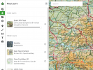
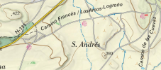
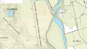
I also love GaiaGPS. The layer I use for Spain is labeled Spain IGN Topo.
Screen Shot 2023-03-06 at 7.37.13 AM.png

The camino is shown with a red shell symbol.
Screen Shot 2023-03-06 at 7.43.53 AM.png
 
Last edited:
Perfect memento/gift in a presentation box. Engraving available, 25 character max.
I have used Gaia before too, but not super experienced with it. I couldn't find anything either, but I thought maybe I wasn't looking in right place. Eager to hear what others have to say!
 
What are the advantages of GaiaGPS?
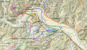
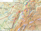
I use Gaia as an index map. I put all the wikiloc tracks I might be interested in walking in a given area onto Gaia so I can see where they intersect. Each track is in a different color. So if I'm in village X, I can open up Gaia, see there are three tracks there that I'm really interested in, and decide to stay a few extra nights. Or I can also see alternatives to a camino route that goes along a highway all day, or that is on the other side of a river from something I want to see, like Los Millares archaeological site. Once I've selected a track for the day from the Gaia index map, I follow it on Wikiloc rather than Gaia (to get the beeps when wandering off track).

In the photo below, the Mozarabe is on the north side of the river and Los Millares is on the south side. Tracks in all different colors show choices for Los Millares and other sites of interest in the area. I have a master list with the wikiloc track number and the color recorded to make it easy to find.
Screen Shot 2023-03-06 at 11.44.06 AM.png

In the next photo, are the choices for Cazorla Parque Natural. We are flying to Spain tomorrow and walking the Ruta del Argar from Almeria to Cazorla and then the GR 247 and alternatives in the park. The forecast is for 77 degrees F this weekend! :cool:
Screen Shot 2023-03-06 at 11.41.37 AM.png
 
Last edited:
€2,-/day will present your project to thousands of visitors each day. All interested in the Camino de Santiago.
The 2024 Camino guides will be coming out little by little. Here is a collection of the ones that are out so far.
Hi all,

I am trying to do some route planning for the Camino. Starting on the Frances, San Salvador and Primitivo. I have used GaiaGPS in the past for hiking in the US. I have not found a good layer for doing snap-to-trail route planning. I assume I'm using the wrong layer - but what layer would have the trail on it?

Thanks.
Vic
There is an explanation of what GAIAgps map products support 'snap to trail' route planning here. Above that are links to the instructions for Android and iOS devices.

Since most of these products seem to be derived from OSM maps, I'm pretty confident you should get a good outcome.

ps. I find it worthwhile using a generic mapping product, although I defer to OSMAnd+. If you are already using GAIAgps for navigation on downloaded tracks, it should be a small step to planning your own routes. But if not, using one of the Camino guide apps is also a good solution.
 
The one from Galicia (the round) and the one from Castilla & Leon. Individually numbered and made by the same people that make the ones you see on your walk.
Does this layer include the Via de la Plata and the Via Serrana? We're walking those this fall.
Yes, to the Via de la Plata. I'm not sure abut the Via Serrana, but I think not. However, the Gaia Spain IGN Topo layer only marks the routes with symbols, not a track. (see photo). You'd probably be happier with a track from one of the many other sources people have suggested above or with importing one of those tracks and uploading it onto Gaia.
Happy walking! Sounds like a great camino.
Screen Shot 2023-03-07 at 9.30.31 AM.png
 
Some of us are interested in learning these techniques, and others are not. Some people prefer to just follow arrows, but perhaps they could also read the thread titles to know where not to go! :cool:
 
Last edited:
Some of us are interested in learning these techniques, and others are not. Some people prefer to just follow arrows, but perhaps they could also read the thread titles to know where not to go! :cool:
I saw a title using Gaia on the camino. I am intimately familiar with Gaia, and know about selecting routes, snapping to, downloading maps, creating your own route, etc. Just wanted to let somebody else know that all that effort is not necessary.
 
...and ship it to Santiago for storage. You pick it up once in Santiago. Service offered by Casa Ivar (we use DHL for transportation).
I saw a title using Gaia on the camino. I am intimately familiar with Gaia, and know about selecting routes, snapping to, downloading maps, creating your own route, etc. Just wanted to let somebody else know that all that effort is not necessary.
Damien, OP here - I will check the other apps but most everything else I've seen did not include elevation. I include elevation when planning my mileage for the day when backpacking and I dont know why I wouldn't on the camino.

The resulting thread from my question turned out to be interesting.

Vic
 
Some of us are interested in learning these techniques, and others are not. Some people prefer to just follow arrows, but perhaps they could also read the thread titles to know where not to go! :cool:
But when you do not have any idea what it is to begin with curiosity may overtake avoidance and that is where the fun begins!
 
Damien, OP here - I will check the other apps but most everything else I've seen did not include elevation. I include elevation when planning my mileage for the day when backpacking and I dont know why I wouldn't on the camino.

The resulting thread from my question turned out to be interesting.

Vic
Buen Camino has elevation profiles for the stages, but you have to be careful because the scale of the graph changes based on the starting point and destination chosen. Sometimes a flat day looks like it may contain a huge mountain even if it is only like 200m. Buen camino!
 
Last edited:
The one from Galicia (the round) and the one from Castilla & Leon. Individually numbered and made by the same people that make the ones you see on your walk.
One other thing... the dedicated apps often contain editorial information about places to see/avoid and recommendations for places to stay. But Gaia + Gronze.com could accomplish the same thing. Buen Camino makes its money on referrals to booking.com and donations (at least I gather.) Wise has a whole guide built in, costs like $4.

Caveat: the one thing i dislike about the apps is that they don't show the cone shaped marker indicating the direction I'm heading (at least on an iOS device.) I saw a woman's screen who had an Android based phone and she had the direction indicator.
 
Hi all,

I am trying to do some route planning for the Camino. Starting on the Frances, San Salvador and Primitivo. I have used GaiaGPS in the past for hiking in the US. I have not found a good layer for doing snap-to-trail route planning. I assume I'm using the wrong layer - but what layer would have the trail on it?

Thanks.
Vic
Try Openrunner . You have french and spanish maps. Make plan on PC/Windows and the sync with android /apple phone. Works offline with downloaded maps ans no battery drainage.
Gaia not working properly here. Buen camino
 
Perfect memento/gift in a presentation box. Engraving available, 25 character max.

❓How to ask a question

How to post a new question on the Camino Forum.

Most read last week in this forum

Anyone had ever encountered any trouble ot unjust behavior from Hospitaleros? If so, what was it and what to do??
I am not a fan of the Camino Francés, I have never walked it and most probabaly never will. (Please don't discuss the pros/cons of this route on this thread). However, despite my strong opinions...
I AM A PLANNER... I was 10 days in on my last camino before I was able to "relax" - that was when I finally had all of my nights booked. Please, do not make this a discussion about "to book or...
Not sure if this is appropriate use of the forum - but I just completed the Camino Frances last week (yay!!!) and bought a souvenir jet/silver ring for myself in Santiago, and the the jet stone...
My wife and I will finish our third camino next June in Santiago de Compostela. We will have approximately a week before we need to be in Lisbon. We are looking for advice for interesting places...

Featured threads

❓How to ask a question

How to post a new question on the Camino Forum.

Featured threads

Forum Rules

Forum Rules

Camino Updates on YouTube

Camino Conversations

Most downloaded Resources

This site is run by Ivar at

in Santiago de Compostela.
This site participates in the Amazon Affiliate program, designed to provide a means for Ivar to earn fees by linking to Amazon
Official Camino Passport (Credential) | 2024 Camino Guides
Back
Top