You are using an out of date browser. It may not display this or other websites correctly.
You should upgrade or use an alternative browser.
You should upgrade or use an alternative browser.
How to measure the distance?
- Thread starter travellover
- Start date
-
- Tags
- phones/apps/gps/maps

Ideal sleeping bag liner whether we want to add a thermal plus to our bag, or if we want to use it alone to sleep in shelters or hostels. Thanks to its mummy shape, it adapts perfectly to our body.
€46,-
€46,-
Actually, after my first Camino (Frances 2008) where I used a tracking device called SPOT, I haven't used anything special other than a guide book and paying attention to the yellow arrows. In most cases it's possible to reach an albergue at the end of a 20 km day. So, how to measure the distance covered enroute. My normal pace is about 4km per hour (includes a 5 minute break every hour) so I plan to cover the 20 KM distance in about 5 hours. This has been a constant for me on the CF, CPort and CIngles. As you walk along getting ready for your Camino, walk a measured distance for an hour and see how far you go. Repeat three times and the average should give you a good approximation. Gauge: 1 mile = 1.6 km
So 20 km = 12.5 miles.
Hope that helps.
Buen Camino,
Arn
So 20 km = 12.5 miles.
Hope that helps.
Buen Camino,
Arn
- Nov 25, 2009
- 11,251
- 48,893
- Time of past OR future Camino
- Frances, autumn/winter; 2004, 2005-2006, 2007, 2008, 2009, 2010, 2011, 2012, 2013, 2014, 2015
Everything that Arn mentioned above is correct, of course. However on a more personal level I still (at 74) mentally "measure" distance walked on the camino by distances I walked or biked long ago as a child. Kindergarten was 1 mile from home, high school 2 miles, and grandma's house just over 12 miles. Hence each camino day I aim "to walk to grandma's".
MM
MM

Technical backpack for day trips with backpack cover and internal compartment for the hydration bladder. Ideal daypack for excursions where we need a medium capacity backpack. The back with Air Flow System creates large air channels that will keep our back as cool as possible.
€83,-
€83,-
I gauged distance using a combo of time (I know I did a steady 4.5-5km/h on the CF) and ground features. I had a list of towns/albergues with a mileage for each from the Godesalco website planner that I tracked distance against.
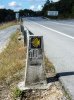
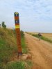
There are also the regular km posts. How accurate they are I dont know.
There are also the regular km posts. How accurate they are I dont know.
There are free apps for your smart phone that will keep track of your daily walking distances and time. They also record the route you walked. It is great to have the mapped daily walks when you return home.. Not needed..but fun.
Two that I have used are: MotionX GPS and MapmyWalk.
They are both simple to use and do not require phone or WiFi connection to operate.
The GPS function is separate from the other.
There are some very good threads on the forum discussing this.
Since these are free you can download one now and use on your practice and training walks to see if you find them interesting. A good way to track your training preparation.
Last edited:
I think a gps is an overkill (unless you are a gadget fan...) I, too, measure my walking time by hours.
About distances... this may be obvious for seasoned pilgrims, but considering that some people come to the forum to take notes for their first walk: yes, a 4 km/hr is an average, but it is another story with bad weather or difficult terrain. With rain, paths becomes very muddy; mountain or hilly terrain slow you down. And, if you plan a winter or early spring walk, be sure you are in an albergue before nightfall.
About distances... this may be obvious for seasoned pilgrims, but considering that some people come to the forum to take notes for their first walk: yes, a 4 km/hr is an average, but it is another story with bad weather or difficult terrain. With rain, paths becomes very muddy; mountain or hilly terrain slow you down. And, if you plan a winter or early spring walk, be sure you are in an albergue before nightfall.

Down bag (90/10 duvet) of 700 fills with 180 g (6.34 ounces) of filling. Mummy-shaped structure, ideal when you are looking for lightness with great heating performance.
€149,-
€149,-
lynnejohn
Veteran Member
- Mar 19, 2006
- 1,257
- 477
- Time of past OR future Camino
- Frances(2005), VDLP(2007), Madrid(2009), Ingles(2009), Sur (2011), VDLP(2011)-partial, VDLP(2014)
There are free apps for your smart phone that will keep track of your daily walking distances and time. They also record the route you walked. It is great to have the mapped daily walks when you return home.. Not needed..but fun.
Two that I have used are: MotionX GPS and MapmyWalk.
They are both simple to use and do not require phone or WiFi connection to operate.
The GPS function is separate from the other.
There are some very good threads on the forum discussing this.
I liked Mapmywalk and have used it over the past year for training. The downside is that it uses up a lot of battery. A walk of 4-5 hours has depleted my battery... so I won't use it on the camino. It's not that important to me to be that precise with how far I've walked.
I liked Mapmywalk and have used it over the past year for training. The downside is that it uses up a lot of battery. A walk of 4-5 hours has depleted my battery... so I won't use it on the camino. It's not that important to me to be that precise with how far I've walked.
I use an external battery pack to back up the phone. They come in many sizes and shapes now and are often on sale.
An advantage of the "juicer" is that you can recharge that instead of your phone in a crowded albergue and not endanger your actual phone.
I will use my fit it to track my miles and upload the distance on the fit it app on my phone. I like mammy hike, but it takes too much battery power. I am OCD with the stats of my walking habits here in Miami, so I can imagine it will only be more interesting on the camino.
Down bag (90/10 duvet) of 700 fills with 180 g (6.34 ounces) of filling. Mummy-shaped structure, ideal when you are looking for lightness with great heating performance.
€149,-
€149,-
D
Deleted member 3000
Guest
You are going to get a lot of badges!!! I got 40,000 once, and 35,000 six times.I will use my fit bit to track my miles
I never bothered. I knew how far to my next stop and just walked until I arrived. I didn't feel the need for more than that.

€2,-/day will present your project to thousands of visitors each day. All interested in the Camino de Santiago.
W
whariwharangi
Guest
Measure your stride.
Determine how many strides from one telephone pole to the next.
Count the telephone poles.
Make a knot in a string for every 100 telephone poles.
Me? I usually lose track after the first couple of poles. At the end of the day I haul out a map ... if I care enough to check.
Milestones are almost as annoying as the kid in the back seat asking 'how many more miles?'
Last edited by a moderator:
tpmchugh
Veteran Member
Never really got hooked on distance. I put one foot in front of the other and I got there when I got there. Doesnt matter if its 5k or 10k to next albergue, you have to walk it so try thinking about something more pleasant than kilometres
egar
New Member
- Jul 27, 2013
- 29
- 33
- Time of past OR future Camino
- Camino del Norte (2013)
Kerry Camino (2017)

3rd Edition. More content, training & pack guides avoid common mistakes, bed bugs etc
Everyone has their own preferences
Some are interested in tracking distance and time....others are not.
Whichever suits you best. There is no right or wrong way.
Some are interested in tracking distance and time....others are not.
Whichever suits you best. There is no right or wrong way.
Kiwi-family
{Rachael, the Mama of the family}
- May 3, 2012
- 3,998
- 10,467
- Time of past OR future Camino
- walking every day for the rest of my life
I thought I didn't care about distances beyond actually arriving each day.....but I've been using Strava just to see what kind of elevations gains we've been doing on practice walks at home and I've discovered looking at the stats at the end of a hike are more than a little bit interesting. We're going to do a 20+km walk at the weekend so I can see how much battery it chews up.
(I, too, started with Map My Walk, but it didn't give any elevation details so I switched to Strava)
(I, too, started with Map My Walk, but it didn't give any elevation details so I switched to Strava)
Thank you for all your replies. I will try some apps to see if anything will be useful. We are going to our first Camino from Valenca this July. I read the guide for the trail and it sounded like you should be aware of km to your next turn. I just afraid that we can be too much distracted with "smelling flowers" on the way and loose track of our location... Maybe I think too much... It is what it is....

Very light, comfortable and compressible poncho. Specially designed for protection against water for any activity.
Our Atmospheric H30 poncho offers lightness and waterproofness. Easily compressible and made with our Waterproof fabric, its heat-sealed interior seams guarantee its waterproofness. Includes carrying bag.
€60,-
Our Atmospheric H30 poncho offers lightness and waterproofness. Easily compressible and made with our Waterproof fabric, its heat-sealed interior seams guarantee its waterproofness. Includes carrying bag.
€60,-
I use a Bad Elf gps that broadcasts via Bluetooth to the Easy Trails app on my iPhone. For those of us that care about how far we have walked and the stats associated with it, this combination is great.
Message me directly of you want more info, that way it is easier to ignore the holier than thou's who come to the GPS section to tell you that measuring distance isn't important and to focus on other things that they think are important.
Message me directly of you want more info, that way it is easier to ignore the holier than thou's who come to the GPS section to tell you that measuring distance isn't important and to focus on other things that they think are important.
I use an app, 'Runkeeper' to log my walks here at home. It records distance, pace, elevations (even calories used!!). Seems fairly accurate and does not use a lot of battery. Although, like Sixwheeler, when walking over distance, I just pick a target stop ahead and walk until I arrive.
- Apr 6, 2013
- 6,248
- 21,174
- Time of past OR future Camino
- 2013 - 2018 , Pilgrim Office volunteer 2014 - 2022
I found the easiest method to gauge distance walked is to use the simple kilometers per hour basis. It goes like this:
3.0 km/hour - on uphill terrain, steep downhills, and in rainy muddy weather - one km each 20 minutes. Not fast, but you will get where you are going safely, and have plenty of time to enjoy the route along the way.
4.0 km/hour - "normal" pace on rolling terrain in reasonably nice weather. This is the baseline - one kilometer each 15 minutes. So, if you look at a map or guidebook and see you have travelled four kilometers, a quick look at your watch will tell you how long it took you to get that far. Less than one-hour, and you are faster than the 4 km/h pace. More than one hour, then you are slower than the pace.
5.0 km/hour - at this pace you are walking FAST; not speed-walking mind you, but still covering one kilometer each 12 minutes or so - if you consistently walk at this pace, I submit you need to throttle back to 4 km/h and enjoy the scenery.
+ 5.0 km/hour - whoa fella! What's the rush. The Camino is a pilgrimage, not a race to be won. There are no prizes for getting there first.
Just BTW - I read a book last year by a guy who walked from St. Jean Pied de Port to Santiago de Compostela in 20 days! Yikes. Evidently, he subsisted on Diet Coke and Mars bars throughout his adventure / race. Seriously! You cannot make this stuff up. Just under 800 kilometers in 20 days is - like really moving along - like about 40 kilometers daily. Okay, he was a 20-something. But, what was the purpose in doing it so fast? Perhaps I was missing something...
Oh well, to each his or her own Camino. It is not for me to judge...just wave or nod as these folks power by me and wish them "Buen Camino!" Also, there is no "Official" standard that peregrinos must comply with. You will see all manner of pilgrim styles out there. From people actually running the Camino, to people intentionally taking the slowest pace to wring everything possible out of what might just be a once in a lifetime experience.
FYI - at 60 years young, I strive for the 4.0 km/hr pace over a day. That allows me to cover a day's walk in 6 to 7 hours. If I hit the road at 07:00, I am usually done by about 14:00, mas o menas...
Enjoy the experience. It is truly profound and ought not be rushed - at least IMHO.

Technical backpack for day trips with backpack cover and internal compartment for the hydration bladder. Ideal daypack for excursions where we need a medium capacity backpack. The back with Air Flow System creates large air channels that will keep our back as cool as possible.
€83,-
€83,-
I would also add that using a GPS or iPhone/smartphone with a GPS app will also give you a record of each day if you save/record.
These are great when you get home and want to write or update a blog/journal.
You can see everywhere you went each day including trips in the woods or behind haystacks. Stops for coffee and lunch are easy to indentify if you leave the unit on.
Up to you to use or not.
These are great when you get home and want to write or update a blog/journal.
You can see everywhere you went each day including trips in the woods or behind haystacks. Stops for coffee and lunch are easy to indentify if you leave the unit on.
Up to you to use or not.
If you are looking for a specific turn off or fork in the road or something like that you could just bring a pedometer that you have set up at home (for pace etc.). My pedometer uses little battery life and will go the entire CF without replacement.
Stefania
Stefania
jmcarp
Veteran Member
- Aug 12, 2012
- 1,286
- 2,528
- Time of past OR future Camino
- Camino Frances, 2013
Camino del Norte a Chimayó (USA), 2015
Camino Portugues, 2017
I found the easiest method to gauge distance walked is to use the simple kilometers per hour basis. It goes like this:
3.0 km/hour - on uphill terrain, steep downhills, and in rainy muddy weather - one km each 20 minutes....
4.0 km/hour - "normal" pace on rolling terrain in reasonably nice weather. This is the baseline - one kilometer each 15 minutes....
5.0 km/hour - at this pace you are walking FAST; not speed-walking mind you, but still covering one kilometer each 12 minutes or so....
Just BTW - I read a book last year by a guy who walked from St. Jean Pied de Port to Santiago de Compostela in 20 days!...
FYI - at 60 years young, I strive for the 4.0 km/hr pace over a day. That allows me to cover a day's walk in 6 to 7 hours. If I hit the road at 07:00, I am usually done by about 14:00, mas o menas...
Enjoy the experience. It is truly profound and ought not be rushed - at least IMHO.
Good advice, and it pretty much matches my own pace -- although I exceed you by 10 years so your averages are at the upper end of my range in those same conditions. However, that is a "walking" pace; my "traveling" pace is a little less because that includes rest stops, photo stops, and cafe con leche breaks, so maybe knock off a half km/hour for that to get an overall average.
BTW, we met a young Englishman one afternoon who told us he had done the CF in 21 days the previous year, and this year he was shooting for 17 days! Oh well, to each his own.

A guide to speaking Spanish on the Camino - enrich your pilgrim experience.
gidivet
Active Member
- Jan 24, 2013
- 177
- 353
- Time of past OR future Camino
- SJPP to SdC - April - June 2014
Le Puy to Conques May 2016
Multiple CF sections since 2014
Hi, I use Endomondo on my phone. It does distance and elevation. It doesn't chew the battery if you switch off unnecessary connections. I tried it with "flight mode" and it recorded the walk, then uploaded it once I got home.I thought I didn't care about distances beyond actually arriving each day.....but I've been using Strava just to see what kind of elevations gains we've been doing on practice walks at home and I've discovered looking at the stats at the end of a hike are more than a little bit interesting. We're going to do a 20+km walk at the weekend so I can see how much battery it chews up.
(I, too, started with Map My Walk, but it didn't give any elevation details so I switched to Strava)
The app has been useful for training because it gives interesting stats about average speed, "lap times" (per km) and gives you a nice map that seems to integrate with Google maps. One benefit is you can look up your route for writing a journal or blog.
tploomis
Active Member
I also used Runkeeper for my camino, and it worked well. It uses GPS, but it does not use much battery. It gives a lot of useful information. It also saves a complete record of how much I walked each day and the elevation profile of the walk -- useful if I want to go back and remind myself of particulars.I use an app, 'Runkeeper' to log my walks here at home. It records distance, pace, elevations (even calories used!!). Seems fairly accurate and does not use a lot of battery. Although, like Sixwheeler, when walking over distance, I just pick a target stop ahead and walk until I arrive.
Last edited:
Kiwi-family
{Rachael, the Mama of the family}
- May 3, 2012
- 3,998
- 10,467
- Time of past OR future Camino
- walking every day for the rest of my life
I tried it today, also on airplane setting. My son sighed when I told him it recorded only the time and not the route or distance. I was supposed to know this would be impossible - at least on an iphone. What's your trick? I'm keen to preserve battery if possible.Hi, I use Endomondo on my phone. It does distance and elevation. It doesn't chew the battery if you switch off unnecessary connections. I tried it with "flight mode" and it recorded the walk, then uploaded it once I got home.
The app has been useful for training because it gives interesting stats about average speed, "lap times" (per km) and gives you a nice map that seems to integrate with Google maps. One benefit is you can look up your route for writing a journal or blog.

A selection of Camino Jewellery
- Jan 21, 2013
- 1,278
- 2,861
- Time of past OR future Camino
- CF 2013, CF from Lourdes 2015, CP Porto 2022
I never got hung up on distances, either.
My smartphone would have been able to track it for me, but I'd be using battery power.
The kilometers per hours posted by t2andreo turned out to be pretty accurate for me and is pretty standard.
The few times I needed to pay attention because I was looking for a turn or a landmark, I found my stride was really close to 1 meter per step and all I had to do was focus on counting. Usually this was a bother, however, because there was so many other more enjoyable things going on around me to focus on!
jmcarp
Veteran Member
- Aug 12, 2012
- 1,286
- 2,528
- Time of past OR future Camino
- Camino Frances, 2013
Camino del Norte a Chimayó (USA), 2015
Camino Portugues, 2017
From the Apple website regarding airplane mode for i-devices: http://support.apple.com/kb/ht1355I tried it today, also on airplane setting. My son sighed when I told him it recorded only the time and not the route or distance. I was supposed to know this would be impossible - at least on an iphone. What's your trick? I'm keen to preserve battery if possible.
While there is no one site that fully describes airplane mode for Android devices (at least not that I have found), a check of the major Android device manufacturers' websites says essentially the same thing for Android devices. So go ahead and play games, browse through your onboard photo albums, and do whatever else you can do that doesn't require GPS or an external network connection while in airplane mode, and console yourself by thinking about all that battery life you're saving. An alternative for measuring distance, elevation gain, etc. might be a dedicated GPS device, but they're no battery misers either.
jmcarp
Veteran Member
- Aug 12, 2012
- 1,286
- 2,528
- Time of past OR future Camino
- Camino Frances, 2013
Camino del Norte a Chimayó (USA), 2015
Camino Portugues, 2017
The only time I counted strides was on a stretch of road between Ponferrada and Cacabelos where someone had painted stripes on the pavement every hundred meters for a few km. I guess they might have been painted for a 5k run. The only reason I counted was to verify that it is, in fact, a million steps from SJPP to Santiago -- at my average pace of 1300 steps per km, it is 1,040,000 steps. This, of course, assumes that all steps are the same, which they are not due to terrain, etc, so it's probably more like a million and a quarter steps when you factor in sight-seeing around the towns and villages.... I found my stride was really close to 1 meter per step and all I had to do was focus on counting...
I confirmed my average walking pace by checking the time between km posts in La Rioja, where the posts are well-placed and the terrain is relatively smooth. Other than that, I had no interest in creating a personal GPS track or log since guidebooks with detailed maps provide all the basic geographic information I needed.
Attachments
A selection of Camino Jewellery
gidivet
Active Member
- Jan 24, 2013
- 177
- 353
- Time of past OR future Camino
- SJPP to SdC - April - June 2014
Le Puy to Conques May 2016
Multiple CF sections since 2014
Hi. I just went out again for a short walk around the neighbourhood with the endomondo app running on both an Android phone and a Windows Phone 8. Both recorded all the necessary stats with Flight mode selected. I cannot comment on the iphone. I will try it again on a longer out-of town walk.I tried it today, also on airplane setting. My son sighed when I told him it recorded only the time and not the route or distance. I was supposed to know this would be impossible - at least on an iphone. What's your trick? I'm keen to preserve battery if possible.
I have been using the Endomondo Sports Tracker for a few years. I like to know where I am and how fast I'm traveling to a fault. It gives me all the information that is important to me such as Speed, Elevation changes, calories burned and distance traveled. My wife and I go on weekend hikes over 10 miles and I have tried most of the apps. I run Endomondo on an old re-purposed Android phone that has no SIM card and runs in Airplane mode. With no cell service the phone will run for days as just a GPS device.
One really nice feature is that your travels for the day and map can automatically be uploaded to Facebook or Google+. For us, that's a big deal since most our friends and family think the idea of trekking across Spain for 6 weeks is mad. Our travels for the day and where we are on a daily basis can be seen by our kids and family. We want to detach as much as possible while on Camino but still let people know where we are.
My plan is to get a local SIM card when in Spain and use it just to call ahead or in case of emergency. Once I have a WiFi connection Endomondo uploads my recorded track and location for the day.
Our Camino begins on June 5th. Looking forward and counting the weeks till departure.
Cheers!
Larry from Sydney
Active Member
- Nov 16, 2013
- 179
- 133
- 68
- Time of past OR future Camino
- Will be starting at SJPDP on the 16th May 2014
Funky skier would a French sim work just as well as a Spanish sim ?
Sent from my iPhone using Camino de Santiago Forum mobile app
Sent from my iPhone using Camino de Santiago Forum mobile app
A selection of Camino Jewellery
I don't see why not. I'm really going on suggestions I've read elsewhere about SIM Cards.Funky skier would a French sim work just as well as a Spanish sim ?
Sent from my iPhone using Camino de Santiago Forum mobile app
Larry from Sydney
Active Member
- Nov 16, 2013
- 179
- 133
- 68
- Time of past OR future Camino
- Will be starting at SJPDP on the 16th May 2014
We are going to do France, Spain, Italy, France so figured buy a Euro Sim and that should help with all aspects - I am interested in Endomondo as that would help if we can down load maps at a WiFi spot and not continually - as I was going to use GPX maps - but Des also wants to measure her steps on walk - any suggestions for this as she does not want another device as she will have a iPhone, Ipod and Camera - a lot of weight in electronics - anyway this is a larger topic as many have done the camino so nothing really new
Google MyTracks on Android will do everything people here seem to want. It'll track you distance,speed,route,elevation and upload the data. It's free to.
Battery use on a current version of the OS is fairly good. I think after a five hour stroll the battery on my Nexus will be over 70%. That's with everything turned ON. GPS,wifi,cell data. The screen will be off while the phone is in my pocket but that's it.
Older versions of the OS weren't so kind to the battery.
You still have full access to Google maps (or other mapping software) on your phone.
Nobody mentioned this but one advantage of things like this is tracking how your body really feels. If you find yourself slowing down it might be a good idea to take a rest. Or even a rest day/week. So it's not all about being a gadget freak.

The one from Galicia (the round) and the one from Castilla & Leon. Individually numbered and made by the same people that make the ones you see on your walk.
I have also used MyTracks with disappointing results. MyTracks is a great app if you want to record a route and still have access to Google Maps. An example would be to record a track in the wilderness and use the app to find your way back, or record the location of a point of interest. The problem with MyTracks and its well documented, is that it is not a good activity tracker. The algorithm that it uses is very poor at rejecting erroneous data points. If you are walking and it gets an erroneous fix that is 100m away, it will add 200m to your distance. That distance and time interval then fouls up your speed computation.
Sorry if I'm getting way far into the weeds on this issue, I've tried every conceivable app and solution and I have gained so much great info from this forum, that I hope what I have figured out is useful to others.
Sports Tracker Apps like Endomondo have been programmed to reject erroneous data points. If your Distance, Duration and Speed are most important, look to a Sports Tracker App. If you want Location and Track Recording, then MyTracks is the way to go.
fraluchi
RIP 2019
- Dec 24, 2007
- 1,360
- 1,447
- Time of past OR future Camino
- One every year since 2007
A guide to speaking Spanish on the Camino - enrich your pilgrim experience.
- Nov 1, 2008
- 11,026
- 23,260
- 71
- Time of past OR future Camino
- 2006 to date: Over 21 Caminos. See signature line
I don't use anything to measure the distance.
I just walk until I get there.
I just walk until I get there.
gidivet
Active Member
- Jan 24, 2013
- 177
- 353
- Time of past OR future Camino
- SJPP to SdC - April - June 2014
Le Puy to Conques May 2016
Multiple CF sections since 2014
Hi, I use Endomondo on my phone. It does distance and elevation. It doesn't chew the battery if you switch off unnecessary connections. I tried it with "flight mode" and it recorded the walk, then uploaded it once I got home.
The app has been useful for training because it gives interesting stats about average speed, "lap times" (per km) and gives you a nice map that seems to integrate with Google maps. One benefit is you can look up your route for writing a journal or blog.
Edit - just a word if warning: I measured Endomondo with all connections apart from GPS switched off against a friend's tracking device and found it was less accurate. It underestimated the distance. I've since walked the Camino Frances and hardly ever used my phone for navigation. The guidebook was good enough.
I use my stomach. I start without breakfast normally. When I get hungry I am half way. When I get hungry again I am there.

The one from Galicia (the round) and the one from Castilla & Leon. Individually numbered and made by the same people that make the ones you see on your walk.
Magwood
Veteran Member
- Feb 19, 2013
- 1,510
- 3,433
- Time of past OR future Camino
- See signature line for links to daily posts to blogs from many caminos
I used 'map my walk' on my iPhone 5 on my camino Portuguese this year. I didn't find it drained my battery too much, but I did have an external battery pack, so this wouldn't have been a problem.
I liked to know how far I had walked and how far remained to be travelled. I was also surprised to note that the distances given in the JB guide book consistently understated the distances my gps device measured, by a minimum of 10% and often more. This made a significant difference to the overall length of the walk which according to JB is 615 km and according to my gps I walked 670 km, including a couple of diversions that would not have added up to more than 20 km.
I would be interested to know if this difference in distance was also noted on the Frances route, which I walked last year without the benefit of gps.
I agree that the stats produced at the end of each day's walk are very interesting, showing elevation and pace. I even became quite fond of 'Penelope Pocket' as I called my app voice (well, she lived in my pocket and she sounded quite posh) advising me when I had completed another km.
I know lots of people would balk at the idea of such a gadget, but I really enjoyed it and make no apologies for liking my toys. Let's just enjoy eachother's differences.
hotelmedicis
Commercial Interests
The easiest, cheapest and most foolproof way that I am aware of is simply to consult a sheet with the distance between towns. I have attached a file to this post (see below and download) so that you can print it out and bring it with you. This is really all you need. Just follow the yellow arrows and use this sheet. Please note the author's name (not me) for credit.
Attachments
Last edited:
3rd Edition. More content, training & pack guides avoid common mistakes, bed bugs etc
- Mar 12, 2011
- 7,548
- 20,382
- Time of past OR future Camino
- Past: a few
Last: Sanabres
Next: St Olav's Way
This might be useful for someone not interested in measuring the distance they have personally travelled who is walking the CF. I think there is a more general issue here that some people want to know what distances they have walked, including detours, elegant route variations and end of day shopping. I have used a dedicated GPS on all my pilgrimage walks for that purpose. I have tried using GPS apps on an older smartphone, and between increased battery use and difficulty getting a good satellite fix, gave up. My new Android phone appears to get a fix more quickly, but there is still a power issue.The easiest, cheapest and most foolproof way that I am aware of is to simply consult a sheet with the distance between towns. I have attached a sheet to this post (see below and download) so that you can print it out and bring it with you. This is really all you need. Just follow the yellow arrows and use this sheet. Please not the author's name (not me) for credit.
BTW, there are several inaccuracies in the other data presented on the sheet @hotelmedicis attached to his post. Don't expect to find a medical centre at Sanbol, but there was a bar and grocery store at Granon when I walked the CF. I suppose this is the difficulty with any information source - there is always the prospect of initial inaccuracy, then things will change over time.
Albertinho
Veteran Member
You did not walk the coastal boardwalk from Matosinhos to Vila do Conde Maggie ? You missed something !I used 'map my walk' on my iPhone 5 on my camino Portuguese this year. I didn't find it drained my battery too much, but I did have an external battery pack, so this wouldn't have been a problem.
I liked to know how far I had walked and how far remained to be travelled. I was also surprised to note that the distances given in the JB guide book consistently understated the distances my gps device measured, by a minimum of 10% and often more. This made a significant difference to the overall length of the walk which according to JB is 615 km and according to my gps I walked 670 km, including a couple of diversions that would not have added up to more than 20 km.
I would be interested to know if this difference in distance was also noted on the Frances route, which I walked last year without the benefit of gps.
I agree that the stats produced at the end of each day's walk are very interesting, showing elevation and pace. I even became quite fond of 'Penelope Pocket' as I called my app voice (well, she lived in my pocket and she sounded quite posh) advising me when I had completed another km.
I know lots of people would balk at the idea of such a gadget, but I really enjoyed it and make no apologies for liking my toys. Let's just enjoy eachother's differences.
View attachment 11367
hotelmedicis
Commercial Interests
This might be useful for someone not interested in measuring the distance they have personally travelled who is walking the CF. I think there is a more general issue here that some people want to know what distances they have walked, including detours, elegant route variations and end of day shopping. I have used a dedicated GPS on all my pilgrimage walks for that purpose. I have tried using GPS apps on an older smartphone, and between increased battery use and difficulty getting a good satellite fix, gave up. My new Android phone appears to get a fix more quickly, but there is still a power issue.
BTW, there are several inaccuracies in the other data presented on the sheet @hotelmedicis attached to his post. Don't expect to find a medical centre at Sanbol, but there was a bar and grocery store at Granon when I walked the CF. I suppose this is the difficulty with any information source - there is always the prospect of initial inaccuracy, then things will change over time.
I see. Yes, that is another topic, albeit closely related. For calculating the number of steps that I take on any given day, I wear a Jawbone on my ankle, which I find more accurate than on the wrist which is also possible. It charges quickly via a USB port and the charge last's 7 days. At any time you can connect it to your mobile phone (Android or iPhone) via Bluetooth and check distances on the app.
Regarding the inaccuracies on the data sheet, I'm sure that many stores, hotels and the like come and go but hopefully the distances remain the same over time.

Technical backpack for day trips with backpack cover and internal compartment for the hydration bladder. Ideal daypack for excursions where we need a medium capacity backpack. The back with Air Flow System creates large air channels that will keep our back as cool as possible.
€83,-
€83,-
BrienC
Author of Camino Child
- Mar 16, 2015
- 366
- 509
- Time of past OR future Camino
- Past: Francés, VDLP, Norte
2022: Portuguese
I used Strava last summer on the CF, SJPdP to Santiago, averaging 40km/day with a 56km max in there. The app was loaded on an iPhone 5S. It never let me down. When I got home, I edited all the GPS data into one file and loaded it into a map of northern Spain. Kind of a fun project. But I'm a gadget head.I thought I didn't care about distances beyond actually arriving each day.....but I've been using Strava just to see what kind of elevations gains we've been doing on practice walks at home and I've discovered looking at the stats at the end of a hike are more than a little bit interesting. We're going to do a 20+km walk at the weekend so I can see how much battery it chews up.
(I, too, started with Map My Walk, but it didn't give any elevation details so I switched to Strava)


Most read last week in this forum
I did not use Bookings.com during my Camino, but most pilgrims I met did. And from this site it is evident that most people use Bookings at least some of the time.
This article is for those of...
Currently I am in Burgos resting up from a knee injury. I am not giving up the possibility of continuing on foot, but in the meantime I would like ideas of options in the event that I can not...
Hi all, just a quickie,
Has anyone else noticed that the older you get, the larger the ratio of medication: kit you carry in your rucksack? This time round it appears to be around 60% walking...
....asked me to remind you that May 12 is the Feast of Santo Domingo de la Calzada.
Hi there,
I will be walking Camino Primitivo soon and I still have some questions that you could maybe help me to answer. As I would like to avoid to bring unnecessary things with me.
1. I do...
Similar threads
- Replies
- 9
- Views
- 1K
- Replies
- 17
- Views
- 2K
- Replies
- 9
- Views
- 3K
❓How to ask a question
How to post a new question on the Camino Forum.
Latest posts
-

-

-

-
 LIVE from the Camino Luka on the Sanabrés
- Latest: Camino Chrissy
Similar threads
-
-
Gronze Maps app in the Apple Store
- Started by Joan Fiol (Gronze.com)
- Replies: 17
-
Best app to accurately record distances, elevation and descent per day
- Started by browneyedsusie
- Replies: 45
-
how to download routes from Gronze
- Started by Shebang
- Replies: 33
Forum Rules

Camino Updates on YouTube

Most downloaded Resources
-
 “All” Albergues on the Camino Frances in one pdf“All” Albergues on the Camino Frances in one pdf
- ivar
- Updated:
-
 A selection of favorite albergues on the Camino FrancésFavorite Albergues along the Camino Frances
- Ton van Tilburg
- Updated:
-
 Profile maps of all 34 stages of the Camino FrancesProfile maps of all 34 stages of the Camino Frances
- ivar
- Updated: