Planning to Walk the Camino Mozárabe de Málaga: Questions and Concerns

AJGuillaume

Pèlerin du monde
May 8, 2017
1,200
3,341
Melbourne, Australia and Romont, Switzerland
Time of past OR future Camino
Via Gebennensis (2018)
Via Podiensis (2018)
Voie Nive Bidassoa (2018)
Camino Del Norte (2018)
Our flights are booked, and we're planning our return to the Camino.

My darling and I walked from Almería last year, starting on 22 September. We also walked the Jaén branch. Unfortunately, we had to interrupt our Camino as there had been a death in my darling's family.

We have decided to return to the Mozárabe, and walk once again from Almería, starting possibly on 24 April, rather than resume from where we had stopped in Castro del Rio. I think we're going to enjoy the spring colours.

When we get to Baena, our plan is to take a bus to Málaga, and after many grandchildren cuddles (our son and his family live in Málaga), we'll walk the Camino Mozárabe de Málaga back to Baena.

So this post is about the Málaga branch, and a few questions we have.

I am using a few references to plan the Málaga branch. Starting with the Asociación Jacobea de Málaga's website. I have found a guide book in Spanish which can only be read using calameo. I have also a PDF guide for the GR245, which I found on the Grand Senda de Málaga website.

As there is a wealth of information on this Forum, I have also read @Magwood 's blog, @Anniesantiago 's blog from Málaga to Cuevas, @amancio 's post, and more recently, @Bad Pilgrim 's account, as well as @dsharpe 's posts.

Those who know us know that we are a slow walking, distance challenged couple, so we hope to be able to report on our walk from that perspective.

I have a few queries:
- I can't afford to get lost: the extra km would possibly cause me to have to carry my darling and her backpack. So I generally use GPX tracks to ensure I am on the right path. Can anyone suggest GPX tracks, please?

- reading through some of the information, it appears that there is a bus, line 21, which would take us to Junta de los Caminos. For those of you who walked from the Cathedral or downtown, would you do it again? Is the walk through the suburbs of Málaga to be avoided?

- is it worth stopping two nights in Antequera to enjoy the sights?

Gracias! Thank you!
 
Very light, comfortable and compressible poncho. Specially designed for protection against water for any activity.

Our Atmospheric H30 poncho offers lightness and waterproofness. Easily compressible and made with our Waterproof fabric, its heat-sealed interior seams guarantee its waterproofness. Includes carrying bag.

€60,-

amancio

Veteran Member
Nov 2, 2007
1,120
3,542
Durcal, Granada
Time of past OR future Camino
Frances, Norte, Primit, Salvador, Portug, Arag, Ingles, VdlP, Leban-Vadin, Fisterra, Invierno, LePuy
Buenos días, compañero!
GRRRREAT CHOICE! The Malaga branch is a surprise, and a beautiful one. Mind you, the first two days are quite hilly, beware.

The path from Malaga to Antequera is very well marked, but if you type "camino mozarable wikiloc" in google, it will show quite a few choices.

Definitely, I would skip the first section, start directly in Junta de los Caminos, a hearty breakfast, a gentle downhill to the dry river bed, and then the mountain festival begins! This said, Málaga is worth a day to visit.

Antequera should have plenty to keep you busy for a couple of days, certainly, I have never seen a place with so many monuments, imposing churches, the Moorish heritage, the prehistorical dolmens.

Mind you, the descent to Antequera is quite rocky, and can be tricky on a wet day!

The rest of the stages can be made shorter than I did, but I think the one to Villanueva de las Algaidas does not offer many options, if you need to shorten it because you are not into longer stages, I would recommend taking a taxi to Cartaojal and skipping the exit of Antequera.

After that, Villanueva de las Algaidas, Cuevas Bajas, Lucena, Cabra and Baena are easy ends of stages.

Main caution is, if heavy rain is expected, the first two stages between Malaga, Almogia and Villanueva de la Concepción, can be prone to flash flooding on all those wild dry river beds, just keep an eye on weather forecasts!

Buen camino!!!
 

Magwood

Veteran Member
Feb 19, 2013
1,509
3,432
Bristol, UK
www.magwood.me
Time of past OR future Camino
See signature line for links to daily posts to blogs from many caminos
Have you come across this guide in English. I found it very useful in 2015, but I’ve no idea if it has been updated.

I wasn’t recording my tracks on the first part of this camino but I had downloaded others’ Wikiloc tracks. If using unofficial tracks, just remember that they might not be 100% accurate and read any notes attached. I’m sure there must be an app with reliable routes.

I don’t remember anything to recommend the walk out of Málaga - hop on the bus.

Antequera is a fabulous city and well worth an extra night if you have time. It sounds as though you are familiar with Málaga which is well worth a couple of days if anyone’s time.

I agree with @amancio about the descent into Antequera. Very, very steep. Take care.

Buen camino!
 
3rd Edition. More content, training & pack guides avoid common mistakes, bed bugs etc
Feb 12, 2015
259
409
74
Australia
Time of past OR future Camino
Frances Portuguese Finisterre Muxia Ingles Mozarabe VldP Sanabres Serrana Salvador Norte Espiritual
Hi,, I started from Malaga,, and walked to Junta de los Caminos for my first day,, nothing special but also perfectly OK,, and for tracks!!
Mapys, cz is the perfect app,,, it's free,,, has nearly every walking track,, Camino already on it,,, and can also download the map of wherever,, so then don't need data,, only gps,,,!!
 

amancio

Veteran Member
Nov 2, 2007
1,120
3,542
Durcal, Granada
Time of past OR future Camino
Frances, Norte, Primit, Salvador, Portug, Arag, Ingles, VdlP, Leban-Vadin, Fisterra, Invierno, LePuy
actually, seing Martyduc's post above, I realized there is an app for mobile which lets you easily download all tracks!


This is the icon for the app:

1672741001830.png

If you download the Malaga province and Cordoba province .mbtiles map files, you will be able to use the app above even offline

You can find maps here


or one single map for the whole of Spain and Portugal and Balearic Islands, pick the "Spanien" option in the page below


the map you download from this page can be used offline in the IGN app or in Orux Maps, among other apps.
 

david46

Should be old enough to know better...
Mar 7, 2014
75
195
Sunderland, UK
Time of past OR future Camino
Frances, Portugese, St. Jaume, Del Sur, Primitivo, Vadiniense, Salvador, Mozarabe
Our flights are booked, and we're planning our return to the Camino.

My darling and I walked from Almería last year, starting on 22 September. We also walked the Jaén branch. Unfortunately, we had to interrupt our Camino as there had been a death in my darling's family.

We have decided to return to the Mozárabe, and walk once again from Almería, starting possibly on 24 April, rather than resume from where we had stopped in Castro del Rio. I think we're going to enjoy the spring colours.

When we get to Baena, our plan is to take a bus to Málaga, and after many grandchildren cuddles (our son and his family live in Málaga), we'll walk the Camino Mozárabe de Málaga back to Baena.

So this post is about the Málaga branch, and a few questions we have.

I am using a few references to plan the Málaga branch. Starting with the Asociación Jacobea de Málaga's website. I have found a guide book in Spanish which can only be read using calameo. I have also a PDF guide for the GR245, which I found on the Grand Senda de Málaga website.

As there is a wealth of information on this Forum, I have also read @Magwood 's blog, @Anniesantiago 's blog from Málaga to Cuevas, @amancio 's post, and more recently, @Bad Pilgrim 's account, as well as @dsharpe 's posts.

Those who know us know that we are a slow walking, distance challenged couple, so we hope to be able to report on our walk from that perspective.

I have a few queries:
- I can't afford to get lost: the extra km would possibly cause me to have to carry my darling and her backpack. So I generally use GPX tracks to ensure I am on the right path. Can anyone suggest GPX tracks, please?

- reading through some of the information, it appears that there is a bus, line 21, which would take us to Junta de los Caminos. For those of you who walked from the Cathedral or downtown, would you do it again? Is the walk through the suburbs of Málaga to be avoided?

- is it worth stopping two nights in Antequera to enjoy the sights?

Gracias! Thank you!
I think taking the bus to Junta de los Caminos is a good idea. I did that when I walked this camino and was glad I did because it looked a really boring, slightly uphill trek through the suburbs. From Juntos you are immediately into the countryside.
 
  • Like
Reactions: islandwalker
Very light, comfortable and compressible poncho. Specially designed for protection against water for any activity.

Our Atmospheric H30 poncho offers lightness and waterproofness. Easily compressible and made with our Waterproof fabric, its heat-sealed interior seams guarantee its waterproofness. Includes carrying bag.

€60,-
Sep 16, 2014
143
311
Time of past OR future Camino
Aragon/CF 08, Arles 10, Le Puy 12, Geneva 14, VdlP 15, Norte/Primitivo 15, VF 17, Levante 18, Moz 19
actually, seing Martyduc's post above, I realized there is an app for mobile which lets you easily download all tracks!


This is the icon for the app:

View attachment 138979

If you download the Malaga province and Cordoba province .mbtiles map files, you will be able to use the app above even offline

You can find maps here


or one single map for the whole of Spain and Portugal and Balearic Islands, pick the "Spanien" option in the page below


the map you download from this page can be used offline in the IGN app or in Orux Maps, among other apps.The ic
 
Sep 16, 2014
143
311
Time of past OR future Camino
Aragon/CF 08, Arles 10, Le Puy 12, Geneva 14, VdlP 15, Norte/Primitivo 15, VF 17, Levante 18, Moz 19
The IGN app icon I see on my phone's app store is the same design, but different colors. Blue over orange, and is called Mapas de Espana Basicos. Is this the same app? Or more limited? It doesn't say anything about 'Aplicaciones en Google Play" so I am thinking it does not have the same functions as what you are showing above. I wonder how I can find your app on my iphone.
 

Madrood

Active Member
Sep 21, 2021
130
297
Ireland
Time of past OR future Camino
Estrecho (2023)
I use this website for my kml/gpx files, which has the major caminos, among other trails.

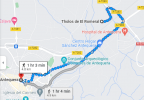
The dolmens appear to be 5 km away from the town centre. If you plan on seeing them, and you've had to deal with a steep descent, then taking the town slowly looks like a good idea.

1672967962415.png
 
  • Like
Reactions: AJGuillaume
Very light, comfortable and compressible poncho. Specially designed for protection against water for any activity.

Our Atmospheric H30 poncho offers lightness and waterproofness. Easily compressible and made with our Waterproof fabric, its heat-sealed interior seams guarantee its waterproofness. Includes carrying bag.

€60,-

amancio

Veteran Member
Nov 2, 2007
1,120
3,542
Durcal, Granada
Time of past OR future Camino
Frances, Norte, Primit, Salvador, Portug, Arag, Ingles, VdlP, Leban-Vadin, Fisterra, Invierno, LePuy
The IGN app icon I see on my phone's app store is the same design, but different colors. Blue over orange, and is called Mapas de Espana Basicos. Is this the same app? Or more limited? It doesn't say anything about 'Aplicaciones en Google Play" so I am thinking it does not have the same functions as what you are showing above. I wonder how I can find your app on my iphone.
it might do the trick , it does have Camino de Santiago and seems to include all stages of many different caminos but, if you have some experience with GPS on the mobile or go hiking often, I would get the full version and download maps to be able to use it offline without using data (and so much battery!)
 

amancio

Veteran Member
Nov 2, 2007
1,120
3,542
Durcal, Granada
Time of past OR future Camino
Frances, Norte, Primit, Salvador, Portug, Arag, Ingles, VdlP, Leban-Vadin, Fisterra, Invierno, LePuy
I use this website for my kml/gpx files, which has the major caminos, among other trails.

The dolmens appear to be 5 km away from the town centre. If you plan on seeing them, and you've had to deal with a steep descent, then taking the town slowly looks like a good idea.

View attachment 139064
actually, the dolmens are just outside town, they are marked in the map as "Conjunto Arqueológico Dólmenes de Antequera" the Tholos de el Romeral is a different place, quite interesting too, but it is a couple of hours to get there and return on foot. The main dolmens are the ones closer to town, and absolutely a MUST to visit!
 
The focus is on reducing the risk of failure through being well prepared. 2nd ed.

krystianw

Member
Apr 13, 2018
64
78
Malaga, Spain
Time of past OR future Camino
Frances, Norte, Mozárabe, Vía de la Plata
I was there last spring.

The walk out of Malaga isn't unpleasant, but definitely not thrilling. But if you're "distance-challenged", then the bus might be worth considering. It took me and my wife two hours to walk Malaga - Junta de los Caminos, but then ALMOST FIVE HOURS to climb up to Almogia. So it might be better if you get a head start on the second half.

Antequera is a very pretty town. But I wouldn't say it stands out that much on the Mozarabe, you'll be seeing other cool places too. But you might want to do a rest day after crossing the mountains, so that would line up pretty well.
 

❓How to ask a question

How to post a new question on the Camino Forum.

Forum Rules

Forum Rules

Camino Updates on YouTube

Camino Conversations

Most downloaded Resources

This site is run by Ivar at

in Santiago de Compostela.
This site participates in the Amazon Affiliate program, designed to provide a means for Ivar to earn fees by linking to Amazon
Official Camino Passport (Credential) | 2024 Camino Guides