I don't think it's "beyond doubt" that the
Via Aquitana formed the first pilgrim route.
On the Spanish section yes, but on the French side of the Pyrenees, it would have been the
Via Romea via Lourdes, Narbonne, etc. between Rome and Santiago -- as there would already have been a degree of support structures for pilgrims on that route when the pilgrimages started to Compostela.
Sure, many Spanish pilgrims to Rome (and/or Jerusalem) would have used the
Via Aquitana to get past the Pyrenees, more or less along the current
Vasco Interior via Irun/Hendaye, and I'd guess Bayonne, but then turn east-southeast up two river valleys > Peyrehorade > Sorde L'Abbaye > likely up the Gave de Pau > Pau > Lourdes and then something like the current
Piémont Way, which is older than the
Camino itself (though likely on what would now be considered tarmac variant routes) ; and only starts being old Roman road again after reaching Carcassonne. The section between Carcassonne and Narbonne is also, confusingly, called the
Via Aquitana, but from Narbonne they would have followed the
Via Domitia/
Via Aurelia (
Via Aurelia became a name not just for the stretch of that road in Italy to Rome, but a general name for the three or four roads stretching between Rome and Cádiz). But I'm not sure his
Via Aquitana nomenclature is correct.
The article makes too much of the road engineering found in certain spots in his introductory remarks, though there is some interesting and very good information on the topic later on in the article. However, on most of their length, most roman roads were just dirt tracks. Sure, on wetter or more uneven terrain some roadworks were needed, as well as to overcome natural barriers such as mountains or rivers, but this has been true in every period since. They tended to be paved as such only when approaching towns and cities (and so currently in the urban or suburban sprawl around historic centres), though the article refers to one rather well preserved exception well away from any settlements.
The author uses the phrase "Dark Ages". No, it's the Middle Ages. Which included the so-called gothic renaissance. Everything did fall apart infrastructurally after the fall of the Western Empire, but the suggestion that things only started improving in the Renaissance is a 16th Century, Endarkenment, and 19th Century revisionist myth.
But the end of the central infrastructures and roads authorities meant that the dirt roads started meandering away from their original routes, often because of private land grabs forcing the road into a new detour, but often also because of an alternative route in a particular location proving to be easier or more practical for the locals, once the routes stopped being needed by the Roman Legions.
The settlement of new villages, monasteries, and so on would also have influenced the shifting away from the Roman routes towards different local ones.
My point is, the routes of the
Camino have been constantly shifting since long before it was even the
Camino.
Furthermore, the author mistakenly suggests that the old Roman route was X, and the
Camino Francès was Y ; whereas pilgrims have always used multiple routes when multiple routes are available, even though nowadays that's often a choice between trail, dirt road, or tarmac. So that comparing the waymarked 20th and 21st Century
Camino with the old routes of the Roman roads is IMO a false comparison.
ALL of those routes are the Camino.
Leaving Astorga, it's not that the
Camino and the Roman road deviate away from each other, it's that the route of the
Camino there avoids the main road. Having at one point considered taking that more Roman route, the current difficulty is that it's more sparsely populated, so with less possibilities of Pilgrim support, and some unavoidable lengths of main road. But it could be a good possibility for some cycling pilgrims, getting better towards Torre del Bierzo, then Las Ventas de Albares, Bembibre, and from there either the Roman route proper to Ponferrada, or for walking pilgrims several friendlier options.
----------
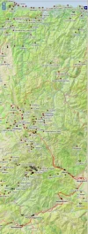
For commentary purposes, here's a couple of maps of the Roman roads network.
First, the major roads :
But here's a more detailed map of the network :
