Search 74,075 Camino Questions

The old roots of the Camino Francés

Time of past OR future Camino
Various 2014-19
Via Monastica 2022
Primitivo 2024
The way we walk on the Camino Francés now is in most places a modern construction, the old road having been covered long since by the Autovia or N-something-or-other (like the N-120 before Sahagun). But there are still plenty of traces of the old route.
I found this fabulous link, describing Roman routes in Castille and Leon, as compared to the medieval camino. Click on the pdf link to see the publication in its original form, with many interesting photos. Clearly, even off the modern highway, camino 'improvements' have sometimes ruined historical traces.

The last stage of the Via de Bayona follows a fairly intact part of one of these roads into Burgos for some ways. It was spectacular.
20190529_083956.jpg
 
Last edited:
Perfect memento/gift in a presentation box. Engraving available, 25 character max.
I love this! Would love to have a big map of all of Spain showing the Roman roads. There are a couple of alternate routes on the Frances that follow the Roman road. I try to follow those when I can. Thanks for sharing.
 
I don't think it's "beyond doubt" that the Via Aquitana formed the first pilgrim route.

On the Spanish section yes, but on the French side of the Pyrenees, it would have been the Via Romea via Lourdes, Narbonne, etc. between Rome and Santiago -- as there would already have been a degree of support structures for pilgrims on that route when the pilgrimages started to Compostela.

Sure, many Spanish pilgrims to Rome (and/or Jerusalem) would have used the Via Aquitana to get past the Pyrenees, more or less along the current Vasco Interior via Irun/Hendaye, and I'd guess Bayonne, but then turn east-southeast up two river valleys > Peyrehorade > Sorde L'Abbaye > likely up the Gave de Pau > Pau > Lourdes and then something like the current Piémont Way, which is older than the Camino itself (though likely on what would now be considered tarmac variant routes) ; and only starts being old Roman road again after reaching Carcassonne. The section between Carcassonne and Narbonne is also, confusingly, called the Via Aquitana, but from Narbonne they would have followed the Via Domitia/Via Aurelia (Via Aurelia became a name not just for the stretch of that road in Italy to Rome, but a general name for the three or four roads stretching between Rome and Cádiz). But I'm not sure his Via Aquitana nomenclature is correct.

The article makes too much of the road engineering found in certain spots in his introductory remarks, though there is some interesting and very good information on the topic later on in the article. However, on most of their length, most roman roads were just dirt tracks. Sure, on wetter or more uneven terrain some roadworks were needed, as well as to overcome natural barriers such as mountains or rivers, but this has been true in every period since. They tended to be paved as such only when approaching towns and cities (and so currently in the urban or suburban sprawl around historic centres), though the article refers to one rather well preserved exception well away from any settlements.

The author uses the phrase "Dark Ages". No, it's the Middle Ages. Which included the so-called gothic renaissance. Everything did fall apart infrastructurally after the fall of the Western Empire, but the suggestion that things only started improving in the Renaissance is a 16th Century, Endarkenment, and 19th Century revisionist myth.

But the end of the central infrastructures and roads authorities meant that the dirt roads started meandering away from their original routes, often because of private land grabs forcing the road into a new detour, but often also because of an alternative route in a particular location proving to be easier or more practical for the locals, once the routes stopped being needed by the Roman Legions.

The settlement of new villages, monasteries, and so on would also have influenced the shifting away from the Roman routes towards different local ones.

My point is, the routes of the Camino have been constantly shifting since long before it was even the Camino.

Furthermore, the author mistakenly suggests that the old Roman route was X, and the Camino Francès was Y ; whereas pilgrims have always used multiple routes when multiple routes are available, even though nowadays that's often a choice between trail, dirt road, or tarmac. So that comparing the waymarked 20th and 21st Century Camino with the old routes of the Roman roads is IMO a false comparison. ALL of those routes are the Camino.

Leaving Astorga, it's not that the Camino and the Roman road deviate away from each other, it's that the route of the Camino there avoids the main road. Having at one point considered taking that more Roman route, the current difficulty is that it's more sparsely populated, so with less possibilities of Pilgrim support, and some unavoidable lengths of main road. But it could be a good possibility for some cycling pilgrims, getting better towards Torre del Bierzo, then Las Ventas de Albares, Bembibre, and from there either the Roman route proper to Ponferrada, or for walking pilgrims several friendlier options.

----------

For commentary purposes, here's a couple of maps of the Roman roads network.

First, the major roads :

ancient-rome-road-map-gettyimages-122216763.jpg


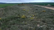
But here's a more detailed map of the network :
te0zkuc8jyz51.jpg
 
The focus is on reducing the risk of failure through being well prepared. 2nd ed.
Don’t forget that Somport was an early pass over the Pyrenees, too. Plus there were (and still often ARE!) smaller Roman roads connecting ports, quarries, etc. just like we have superhighways and local roads now.
 
The focus is on reducing the risk of failure through being well prepared. 2nd ed.
How do the layers / legend work?
For example, not sure what Zoom/10 means in regard to adding modern place names
I'm not sure what you're referring to, @Robo but if you click on the tab that says 'layer' it gives a bunch of options that it can display if you click on that option.

Legend just is like a legend on a regular map.

If you want modern place names, click on a labeled place on the map and then go to the places tab, and you'll see lots of information displayed (this is on a PC, not a smartphone, BTW).
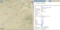
For example, here's what happened when I clicked on Deobrigula (the yellow pointer):
Capture.webp
 
I'm not sure what you're referring to, @Robo but if you click on the tab that says 'layer' it gives a bunch of options that it can display if you click on that option.

Legend just is like a legend on a regular map.

If you want modern place names, click on a labeled place on the map and then go to the places tab, and you'll see lots of information displayed (this is on a PC, not a smartphone, BTW).
For example, here's what happened when I clicked on Deobrigula (the yellow pointer):
View attachment 111764

Many thanks.
 
A selection of Camino Jewellery
Playing with the overlays is fascinating.
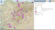
A lot is technical, but there are overlays that are quite mind-blowing. For example, look at the gold mines between what is now Astorga and Lugo.
We think of Las Medulas and a few sites nearby, but those Romans were busy everywhere.
Capture.PNG
All the silver mines were in the south; there were many of them between What are now Cordoba and Merida.
 
Last edited:
Playing with the overlays is fascinating.
A lot is technical, but there are overlays that are quite mind-blowing. For example, look at the gold mines between what is now Astorga and Lugo.
We think of Las Medulas and a few sites nearby, but those Romans were busy everywhere.
View attachment 111765
All the silver mines were in the south; there were many of them between What are now Cordoba and Merida.
Thanks for this thread. When I finished the Ingles, we toured for three days, so I know the names of many of the places on and around the area from the river up to the coast where you can find Las Catedrales. I salute everyone who has chugged up the steep roads/ paths around there! I had my heart in my mouth as a passenger in the car! I know it will never be a camino for me, but that does not stop me from appreciating the research that uncovers past activities and stories. I am once again reminded that we know where we are going when we know from whence we have come...
I found a short, beautifully accompanied drone video.. for those who don't mind drones...
 
The maps posted on this thread are amazing! I had no idea the Romans had so much going on in Iberia.
 
€2,-/day will present your project to thousands of visitors each day. All interested in the Camino de Santiago.
The maps posted on this thread are amazing! I had no idea the Romans had so much going on in Iberia.
Aren't they?

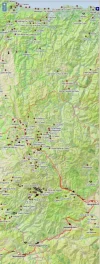
The equally amazing thing is that when the Romans arrived, they encountered a place that was populated by many cultures that had been here for ages - and most of us have almost no awareness of them. In places, the map hints at that - and inferrentially, what a bloody struggle it must have been to subdue and conquer the peninsula. Have a look at what is now eastern Galicia, near the mother lode of Las Medulas - there is a sea of brown circles, each of which is a castro!
20211023_084327.jpg

Elsewhere, @alansykes just passed through Soria and visited Numancia, where Celtiberians tried to hold the line. It became an important defensive settlement and a place where five roads met. We live in interesting times. But those times were orders of magnitude more interesting.
About an hour later, after a little climb, I got to the ruins of Numancia, an iron age hill fort partly guarded by the Duero forming a moat on three sides, and giving spectacular views forward and back. It was here that the celtiberians resisted Scipio in a siege lasting almost a year, finally committing mass suicide rather than surrender. Unfortunately, lacking a Josephus, or indeed an alphabet, they are somewhat over-shadowed by Masada. Cervantes wrote a play about the events.

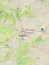
It shouldn't be any surprise that our modern routes follow old ones, but it's somehow satisfying to see the congruence. In the modern OSMand map on the right, the Caminos Castellano-Aragones and Segunto are the turquoise lines.
20211023_090341.jpg20211023_090320.jpg
 
Last edited:
The first edition came out in 2003 and has become the go-to-guide for many pilgrims over the years. It is shipping with a Pilgrim Passport (Credential) from the cathedral in Santiago de Compostela.
I love seeing those castros and it's great to see so many on a map! I want to visit them all! That civilization is still such a mystery to us.

The New World "Camino Real" - the route from Mexico City to north of what is now Santa Fe, New Mexico (modern names) - was an indigenous foot trail long before the Spanish used it to head north in the late 1500s. Who knows how old it really is. Artifacts found in ancient Indigenous ruins along the way attest to its long history as a trade route for native peoples. It snaked through my town Albuquerque and passed only blocks from my house. I like to think of that, while waiting at the stop light with a Burger King on one corner, a pawn shop and a tire repair place across the street.
 
The 2024 Camino guides will be coming out little by little. Here is a collection of the ones that are out so far.
Wonderful, @Jabapapa, thank you very much for posting this. I hope there adventurous pilgrims out there on the CF who will take that fork in Tadarjos. This area is probably my favorite of the entire Francés, so...I want to walk this!
 
Last edited:

❓How to ask a question

How to post a new question on the Camino Forum.

Most read last week in this forum

Can you tell me anything about the structure in my photograph? What was it part of, when was it built? that sort of thing. Thanks.
Feeling a little alone at CF. Where is it most likely that I won't be the only one in the albergue, Villar de Masarif, Villavante, Hospital de Orbigo or Astorga (which is probably too long for me...
I’m planning another Camino Frances, but this time can only do part of it. I’ll be walking from Pamplona for around 2 weeks; I like to walk around 22km a day, depending on the heat (I’m going...
Our Camino Parcel Saga Pamplona May 02 2024 We had just walked across the Pyrenees from St Jean Pied de Port, France. Our plan was to walk 800km along the Camino de Santiago. As it would...
I’m planning my fourth Frances for September/October of 2025. I’m bringing two friends from England, and they would prefer walking late September and finishing in late October. I’ve started in...
I’m looking for suggestions for a 6/7 day walking stage on the Frances that I can do next year with my older less fit companion. We’ve done the stages from Sarria, Ferrol & Tui in recent years. It...

Featured threads

❓How to ask a question

How to post a new question on the Camino Forum.

Featured threads

Forum Rules

Forum Rules

Camino Updates on YouTube

Camino Conversations

Most downloaded Resources

This site is run by Ivar at

in Santiago de Compostela.
This site participates in the Amazon Affiliate program, designed to provide a means for Ivar to earn fees by linking to Amazon
Official Camino Passport (Credential) | 2024 Camino Guides
Back
Top