• For 2024 Pilgrims: €50,- donation = 1 year with no ads on the forum + 90% off any 2024 Guide. More here.
    (Discount code sent to you by Private Message after your donation)
  • ⚠️ Emergency contact in Spain - Dial 112 and AlertCops app. More on this here.

Search 69,459 Camino Questions

Confusion before Cercedilla

David Tallan

Moderator
Staff member
Time of past OR future Camino
1989, 2016, 2018, 2023, 2024...
Just thought I'd alert people to one possible point of confusion on the Camino de Madrid, based on my experience today.

In general, I use both the physical markings (yellow arrows, mojones, etc.) and GPS tracks to keep me on course. This often works well. If I don't see the markings for a bit, I can use the GPS tracks (either the CNIG tracks imported into Google Maps or the Buen Camino app with the tracks they use) to confirm I'm okay or lead me back to the path. Sometimes I'll use the GPS tracks to get a sense of what's coming up so I know to look out for the markings. Generally, they are in alignment. Sometimes they differ a bit but it is no biggie. Today there was a substantial deviation that caused confusion.

I had been walking along the side of a paved road, following both the markings and the GPS tracks. I knew from the GPS that I was soon going to come to a place where the trail would leave the road (as it often does on the CdM). I was keeping an eye out for the yellow arrows. After a while, I thought "I should have turned off by now" so I checked the app. Sure enough, I should have turned off a ways ago, according to the GPS tracks. I went back to look, keeping an eye on the GPS the whole time, to find exactly the right spot. There was nothing there. I went up and down the road a bit because there is some wiggle room in GPS coordinates. No markings. There wasn't a single clear trail, either. There was a whole network of intersecting trails heading steeply down into deep woods. Without any trail markings, I wasn't sure what to do. I checked the tracks both from Buen Camino and CNIG and they both said to head off into the woods. Fortunately, a Spanish guy came along and told me the yellow arrows continued down the road. I decided following they yellow arrows was safer than following the GPS track. It is too easy to get lost in the woods. It was worth the extra distance.

It seems to me it would be less confusing if either:
- The GPS tracks were updated to follow the marked route.
- The markings were changed to follow the shorter GPS route.
- Probably easiest to accomplish, the volunteers painting the arrows add a few around where the GPS tracks tell you to turn off, pointing down the road. Then pilgrims would know that, despite the GPS tracks, they are to continue.

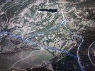
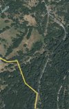
Here's a screenshot to show you where I am talking about. The blue line is the GPS track. The red/pink highlighter is to show you the roads that the yellow arrows send you along instead, although there are none anywhere near where the GPS veers off.
Screenshot_20230608_194704_Maps~2.jpg
 
Very light, comfortable and compressible poncho. Specially designed for protection against water for any activity.

Our Atmospheric H30 poncho offers lightness and waterproofness. Easily compressible and made with our Waterproof fabric, its heat-sealed interior seams guarantee its waterproofness. Includes carrying bag.

€60,-
David, I had the same problem. You should have taken a left just after you turn left at the
restaurant. It was marked with yellow arrows, but Buen Camino had you staying on the road. Here’s what I posted —

“At the Lafonda Real restaurant outside Cercedilla, you’ll turn left on a paved road. Watch for yellow arrows, indicating a turn left off the road. Don’t keep following the paved road as indicated by the Buen Camino app like I did. It’s not a good idea🙄😳
Makes for a longer walk.”

A nice jogger tried to help me figure it out. Eventually I bushwhacked down to the trail from the road, which kept me from going all the way down to the arroyo. That was the day I started to lose faith in the Buen Camino app. I eventually switched to the Gronze map when I needed a GPS check.
 
Get a spanish phone number with Airalo. eSim, so no physical SIM card. Easy to use app to add more funds if needed.
Looking at Gronze vs the Buen Camino map it looks like Gronze takes you on a detour near the Casanova de Navalmedio whereas Buen Camino cuts straight across on Las Hojarascas and Avenida de Manuel Gonzalez Amezua. You can see in the photos below the difference. For those that have walked it what are your thoughts?

First photo is from Gronze, second from Buen Camino.IMG_5047.jpegIMG_5044.png
 
I had exactly the same problem in May last year - a big bend (because I followed the arrows on the road), which in the end I thought was made only to pass the accommodation "Casona de Navalmedio " where the road turns sharply left from the asphalt to the dirt road and "back" towards Cercedilla. The turn made by the arrows is marked dashed.
 

Attachments

  • cercedilla 1.jpg
    cercedilla 1.jpg
    759.2 KB · Views: 41
I used the Mapy.cz app (it's free), which has camino routes already marked on their maps.

Mostly it is fantastic - but it does not always line up with the arrows. The Mapy map showed the camino following the road -- but you could see that there was a trail running parallel to the road through the woods. I remember checking the map a lot to see where to turn off...but, once I did, the path was easy to follow and then joined back up with the road after a little while.

At various times when the route on Mapy disagreed with the arrows in front of me, it seemed like it was maybe because they were catering for cyclists rather than walkers in that section. That's what I thought in that part. I went into the woods because I thought it would be cooler!
 
New Original Camino Gear Designed Especially with The Modern Peregrino In Mind!
I am taking comfort in the fact that I haven’t been the only pilgrim to have found this confusing…😅

But in an effort to help future pilgrims, I’ve tried to compare the Buen Camino and Gronze maps. And I apologize to the Buen Camino folks, because it looks like their route makes the most sense.

Here’s a screenshot of the Buen Camino map:
IMG_1640.png

Here‘s a screenshot of the Gronze map, with my red arrows marking what looks to me like the Buen Camino route:
IMG_1639.jpeg
Gronze routes you to Casona de Navalmedio. Not sure why, as @m108 noted, as it’s pretty far out of the way. And if you stay on the paved M601, that takes you way out of the way.
 
Last edited:
I am taking comfort in the fact that I haven’t been the only pilgrim to have fLund this confusing…😅

But in an effort to help future pilgrims, I’ve tried to compare the Buen Camino and Gronze maps. And I apologize to the Buen Camino folks, because it looks like their route makes the most sense.

Here’s a screenshot of the Buen Camino map:
View attachment 148952

Here‘s a screenshot of the Gronze map, with my red arrows marking what looks to me like the Buen Camino route:
View attachment 148953
Gronze routes you to Casona de Navalmedio. Not sure why, as @m108 noted, as it’s pretty far out of the way. And if you stay on the paved M601, that takes you way out of the way.
But what you have marked in red is not what Buen Camino is doing in your snapshot from them. Maybe it is what they want to do but it isn't what their track does. Your red track leaves the main road when the main road is still going a little south of due west, before it turns north. Their GPS track leaves the road well after it has turned north, about half way up. As such, it doesn't follow that track you have it going along.
 
But what you have marked in red is not what Buen Camino is doing in your snapshot from them. Maybe it is what they want to do but it isn't what their track does. Your red track leaves the main road when the main road is still going a little south of due west, before it turns north. Their GPS track leaves the road well after it has turned north, about half way up. As such, it doesn't follow that track you have it going along.
David that’s what the Buen Camino App shows more or less. I think the App has you go just a little more up the road then the red arrows show, the pic from M108 is a little more exact. Did you download a map from them that might be different?
 
Technical backpack for day trips with backpack cover and internal compartment for the hydration bladder. Ideal daypack for excursions where we need a medium capacity backpack. The back with Air Flow System creates large air channels that will keep our back as cool as possible.

€83,-
David that’s what the Buen Camino App shows more or less. I think the App has you go just a little more up the road then the red arrows show, the pic from M108 is a little more exact. Did you download a map from them that might be different?
Here's what Buen Camino shows me. Laurie's route has you leaving GR-10 before you round the corner. The Buen Camino map shows you rounding the corner and heading a considerable amount up the road before leaving the GR-10. Before you turn the corner, there is a path to go on, as shown on the Gronze map. After you turn the corner and head up the road, there is nothing. At least nothing that I and a helpful local could find.
Screenshot_20230610_173206_Buen Camino.jpg
 
Here's what Buen Camino shows me. Laurie's route has you leaving GR-10 before you round the corner. The Buen Camino map shows you rounding the corner and heading a considerable amount up the road before leaving the GR-10. Before you turn the corner, there is a path to go on, as shown on the Gronze map. After you turn the corner and head up the road, there is nothing. At least nothing that I and a helpful local could find.
View attachment 148977
I get what you’re saying now. I thought you were saying your version do Buen Camino was having you do either of the “deviations” in the pictures below. I’ll look in September to see if I see Laurie’s route and report back if someone else doesn’t before then. Buen Camino!IMG_5054.jpegIMG_5053.jpeg
 
I looked up this location with the IGN Mapas de España app. The Camino de Madrid & GR 10 is the blue line. The cross hairs are at the northern point of the camino as marked by yellow arrows (See David's pink highted route in the map at post #1). That location is at the coordinates below.
Screenshot_20230610-150801.png Screenshot_20230610-151219.png
 
St James' Way - Self-guided 4-7 day Walking Packages, Reading to Southampton, 110 kms
David, I see I was confusing the M601 with the narrow paved road. You’re right, the Buen Camino route does follow the paved road (not the M601) for quite a while. As I recall, I couldn’t find a path leaving the paved road where BC says you should, thus my bushwhacking episode. It’s still better than the Gronze route, which takes you all the way up to Casona.

I like my route the best! In fact when I zoomed in on the Buen Camino app, it looks like it’s labeled as the “Manazares El Real Cercedilla“ path (unpaved). Derek, please do let us know what you find!

IMG_1640.png
 
I looked up this location with the IGN Mapas de España app. The Camino de Madrid & GR 10 is the blue line. The cross hairs are at the northern point of the camino as marked by yellow arrows (See David's pink highted route in the map at post #1). That location is at the coordinates below.
View attachment 149002 View attachment 149003
For IGN routes I've been using their GPS tracks on a Google Map. Using their own app is a good idea.
 
In mapy.cz , it looks like this :

Cercedilla 1.jpg

Cercedilla 2.jpg

It shows the GR10 as taking the shortcut, Camino and the cycling route going the long way.

Maybe give it a try ? It's 100% free.
 
Last edited:
Ideal sleeping bag liner whether we want to add a thermal plus to our bag, or if we want to use it alone to sleep in shelters or hostels. Thanks to its mummy shape, it adapts perfectly to our body.

€46,-
I shall be walking the Madrid for the second time this fall. Having read this thread and looked at all the diagrams, I cannot at present make any sense of any of it, except that the camino route seems to lead out of a more major road which goes left to Cercedilla. I hope to meet a local out walking whom I can follow into town.
 
I shall be walking the Madrid for the second time this fall. Having read this thread and looked at all the diagrams, I cannot at present make any sense of any of it, except that the camino route seems to lead out of a more major road which goes left to Cercedilla. I hope to meet a local out walking whom I can follow into town.
What dates are you traveling? If I’m ahead of you I’ll send you an update!
 
Thank you. I'm leaving Madrid for Tres Cantos on Oct. 2nd, to Manzanaras el Real the next day, then on Oct. 4th to Cercedilla. Oddly, I don't recall any problem getting there on my previous walk. Only the variety of maps and markings here confuses me.
 
Down bag (90/10 duvet) of 700 fills with 180 g (6.34 ounces) of filling. Mummy-shaped structure, ideal when you are looking for lightness with great heating performance.

€149,-
Thank you. I'm leaving Madrid for Tres Cantos on Oct. 2nd, to Manzanaras el Real the next day, then on Oct. 4th to Cercedilla. Oddly, I don't recall any problem getting there on my previous walk. Only the variety of maps and markings here confuses me.
I don’t think there’s any problem just several different paths there, one better than the other. I’ll try and see if it’s obvious and let you know.
 
I’ll also be watching with interest as I leave Madrid on the 4th October. It’s good to know there’ll be at least a few other people on the path at the same time. My reading of recents posts live from the Madrid Camino seem to show that we will get there in the end, it’s as you say, Derek, that one just is better than others. I wonder if part of the problem is having too much information and too many options. All part of the adventure.
 
Thank you. I'm leaving Madrid for Tres Cantos on Oct. 2nd, to Manzanaras el Real the next day, then on Oct. 4th to Cercedilla. Oddly, I don't recall any problem getting there on my previous walk. Only the variety of maps and markings here confuses me.
I walked the same year you did ,Albertagirl and can't remember any confusion before Cercedilla. I just followed the arrows. Look forward to your posts from second Camino Madrid.
 
Join our full-service guided tour and let us convert you into a Pampered Pilgrim!
I shall be walking the Madrid for the second time this fall. Having read this thread and looked at all the diagrams, I cannot at present make any sense of any of it, except that the camino route seems to lead out of a more major road which goes left to Cercedilla. I hope to meet a local out walking whom I can follow into town.
I plan to walk the Madrid starting on 11 Sep and will be posting on here so if anything is awry I will probably mention it.
 
I walked this section today and I understand what the confusion is over the routes. The route in the Buen Camino app shows a crossover on the road that doesn’t exist. You have to leave the road earlier or do what David did. Sadly both are posted with arrows so if you miss the ones on the ground you’ll go the long way. I deliberately walked past the short way to see what happens and can show you below in the photos

Photo of the map with the restaurant as the orange dot
IMG_6477.jpeg

Blue dot below shows where yellow arrows on the ground left side of road are for the short cut , see next picture for these arrows

IMG_6475.jpg

Shortcut arrows
IMG_6472.jpeg

Once you walk past the shortcut there are arrows on the road and other markers leading you the long way around
IMG_6474.jpeg

My crude scribble below shows the first arrow where Buen Camino wants you to cross. No paths there and a great way to break a leg.
Second arrow shows a cow path I took with yellow dots that reconnect to the real path. One you reconnect it’s a large well marked path. So in short take the first turn off to save time, but if you miss it its well marked the rest of the way. (Cow path optional) Now how do we get Buen Camino to fix this???

IMG_6478.jpeg
 

Attachments

  • IMG_6478.jpeg
    IMG_6478.jpeg
    33.3 KB · Views: 0
David, I see I was confusing the M601 with the narrow paved road. You’re right, the Buen Camino route does follow the paved road (not the M601) for quite a while. As I recall, I couldn’t find a path leaving the paved road where BC says you should, thus my bushwhacking episode. It’s still better than the Gronze route, which takes you all the way up to Casona.

I like my route the best! In fact when I zoomed in on the Buen Camino app, it looks like it’s labeled as the “Manazares El Real Cercedilla“ path (unpaved). Derek, please do let us know what you find!

View attachment 149004
See my post later in the thread. The app is wrong and one is following arrows you could end up on either route. Someone could get hurt crossing where the Buen Camino app shows
 
Join our full-service guided tour and let us convert you into a Pampered Pilgrim!
See my post later in the thread. The app is wrong and one is following arrows you could end up on either route. Someone could get hurt crossing where the Buen Camino app shows
Derek,
Thank you for taking the time (and effort) to clarify this. I can attest to the danger in trying to follow the Buen Camino map — I finally gave up, left the road and made my own path. Not advisable. I’ll try to send a message to the BC folks. They really need to fix this.
Have a wonderful walk on the Madrid!
Laurie
 
Thanks for clarifying this. I use maps.me and had no trouble with this route my previous time through (2019). But I can see that the arrows are currently fainter than I remember them, after a few more years of rain, and perhaps, inadequate care during the pandemic. I shall try to be very careful here.
 
Get a spanish phone number with Airalo. eSim, so no physical SIM card. Easy to use app to add more funds if needed.
Derek,
Thank you for taking the time (and effort) to clarify this. I can attest to the danger in trying to follow the Buen Camino map — I finally gave up, left the road and made my own path. Not advisable. I’ll try to send a message to the BC folks. They really need to fix this.
Have a wonderful walk on the Madrid!
Laurie
I did the same much to the chagrin of the Spanish peregrina I was walking with. When she saw how we connected to the cow path she was apprehensive until we saw arrows on the main path. (She has a fear of 1000lb animals with sharp horns for some reason…)
 

❓How to ask a question

How to post a new question on the Camino Forum.

Forum Rules

Forum Rules

Camino Updates on YouTube

Camino Conversations

Most downloaded Resources

This site is run by Ivar at

in Santiago de Compostela.
This site participates in the Amazon Affiliate program, designed to provide a means for Ivar to earn fees by linking to Amazon
Official Camino Passport (Credential) | 2024 Camino Guides
Back
Top