

- Time of past OR future Camino
- First: Camino Francés 2002; most recent: Norte/Primitivo 2019
The Camino del Norte leaves the coast in Deba and doesn’t return until Playa de la Arena, some 104km later. This includes a lengthy urban jaunt through Bilbao, and some other significant stretches of pavement. To be clear, there’s some great walking in that stretch! It would be a shame, in particular, to miss the lovely wooded stage linking Deba and Markina, and Gernika is a town of tremendous historical significance. Your mileage may vary on the walk through Bilbao, but I’ve always found that to be quite memorable, regardless of which approach I followed.
All of that said, I’ve had my eyes on a coastal variant linking Gernika and Portugalete/Las Arenas for years now, and I finally had the chance to check it out this past summer. This is the GR123, and while it may not be as easy as that, it’s well way-marked and offers a great option for people who are motivated first and foremost by natural beauty and coastal walking on the Norte. You can find the GPS track here.
The Camino del Norte between Gernika and Portugalete is at least 56km, following the recommended East Nervión variant. (The official route, on the west side of the river, adds a couple km to the walk.) By contrast, the GR123 spans 68km, so this adds significant distance to the walk. Coastal walking inevitably involves some ups and downs, as you’ve learned well in the preceding stages through the Basque Country, and the GR123 features a pair of ~500m ascents. It begins and ends, though, with very long, flat sections, so while it can fairly be described as more strenuous than the Norte in this section, it’s not gruelingly so.

One of the joys, to me, of walking through this section was to see a part of coastal Basque Country that is off the well beaten tourist track, in contrast to those preceding Norte stages. In the peak of summer, I saw local surfing camps for kids, families eating ice cream in plazas, and Basque teenagers roaming around small towns. Certainly there were tourists out there–especially at one notable spot–but the ratio of locals to outsiders flipped dramatically here.
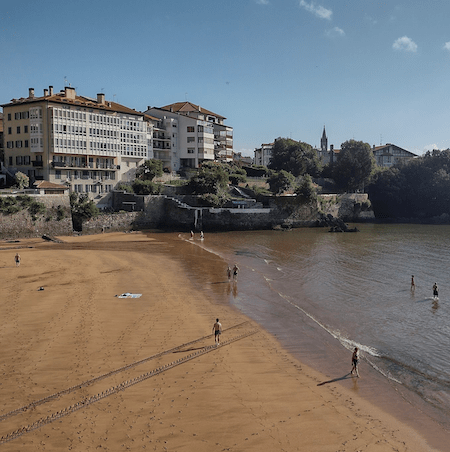
Leaving Gernika, the GR123 splits with the Norte just east of the center, following the Río Oca. This is easy, riverside walking, on a pedestrian track. Make sure you’re on the westside of the river, though–the GR123 is on both sides! After 6km, the footpath veers inland, leading to the first village of the walk, San Kristobal, where it’s possible to grab a coffee. After winding through agricultural fields along some quiet, paved roads, the GR123 returns to the river and arrives at its first beach, Playa San Antonio in the village of Abiña, 4.6km later.
A less interesting stretch of walking follows, largely on paved roads through neighboring Sukarrieta (check out the Jardín Botanico on Txatxarramendi Isla if you have the time), and then along the highway (with an ample sidewalk) into Mundaka. 14km from Gernika, Mundaka has a lovely setup, with its two major religious buildings–the Iglesia de Santa María and the Érmita of Santa Katalina–positioned on two different, rocky promontories, jutting out into the Atlantic, and surrounded by grassy, tree-lined parks.
Sadly, the walk is highway-bound once again leaving Mundaka, pretty much all the way–3.1km–onward to the next town, Bermeo. This is a big spot, with a thriving central plaza, and all services available. This is also where one of the train lines ends, so it’s very easy to backtrack to Gernika from here if you’d like to spend an extra night there, or if you’d like to skip over this first chunk of the GR123.
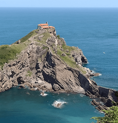 One of the two notable ascents begins after Bermeo, as the route cuts inland through forested hills. 7.5km stand between you and the most famous site on the GR123–the stunning Gaztelugatxeko Doniene, or Ermita de San Juan de Gaztelugatxe. The chapel, sitting proudly atop the small, rocky island, is dramatic enough, but its the grand staircase linking mainland and island that really capture the imagination. Thanks to Game of Thrones, the site now draws large numbers of international tourists, so reservations are required. Without a reservation, you’re limited to taking in the site from a distance. Note that if you are lucky enough to have a reservation, you’re also signing up for an extra couple kms of walking and a lot of stairs! If you arrive early, there’s a restaurant on site to keep you occupied.
From the Ermita, it’s an easy, mostly downhill stroll into Bakio, a pleasant town with a big beach, very popular with surfers. There’s even a hostel, Albergue La Parra. It’s much pricier than a pilgrim albergue, but the facilities are nice, and the accompanying bar/restaurant is hopping. At this point, you’re 27.5km from Gernika.
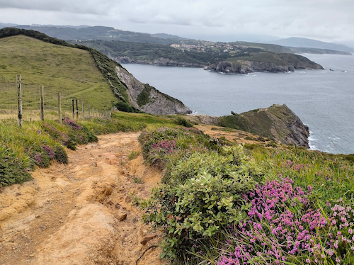
The second notable ascent follows Bakio, once again leading you inland from the coast through thick woods. Aside from occasional, short stretches, this is largely unpaved, thoroughly enjoyable walking. It’s nearly 12km to the next village, Armintza, so it’s enough time to relish the natural beauty without having to wait too long for another coffee! Armintza is a gem of a fishing village–it feels isolated here, cut off from all the surrounding hustle and bustle, and the absence of a good beach (there’s a “beach,” but don’t plan your holiday around it) probably further insulates it from tourism. If you were looking for a Basque beach town to get away from it all, here’s the place.
Another 8.5km of quiet, inland walking follows, with another ascent though not as significant as the preceding pair. After passing around the Faro (lighthouse) de Gorliz, the GR123 descends southward, following a long, sandy beach, skirting the edge of Gorliz, before arriving in the center of Plentzia. This is where one of the metro lines from Bilbao concludes, which opens up all kinds of possibilities for overnight accommodations.
 After having to work way too hard to cross the Plentzia River (could we add a pedestrian bridge?!), and making a short inland crossing, the GR123 returns to the coast, and it will almost exclusively hold to the coast for the remainder of the walk. The first 13km of this last stretch is mostly rural, with occasional beaches, parks, and cafés dotting the way. Once the Cantabrian Sea hits the Puerto de Bilbao, and the GR123 turns southward, though, you’re largely walking through coastal communities on paved promenades. There is some impressive old architecture and loads of restaurants, so you certainly won’t go hungry as you make the final approach to the Puente Colgante, which will carry you on to Portugalete.
All told, this walk works well divided into three stages, walking 27.5km to Bakio (and Albergue La Parra), 20.5km to Plentzia, and 20km to Portugalete. The latter two destinations give you some options. For example, if you were happy to not walk through Bilbao but didn’t want to miss the city entirely, you could book an accommodation in Bilbao for two nights, taking the metro in/out of both Plentzia and Portugalete. There are, of course, hotels available in most of the towns and villages along the GR123, so it’s also entirely possible to take that approach, and break this into shorter stages.
Is it worth it? If you’re making your first pilgrimage on the Camino del Norte, I’d advise you to stick with the Camino. The walk from Gernika to Larrabetzu is very pleasant, I love the descent from Monte Avril into Bilbao, and as I wrote, I think the approach through most of Bilbao is memorable and distinct from most of the rest of the Norte. For a second pilgrimage, though, this is a great way to see a very different part of Basque Country, and Gaztelugatxe is an unforgettable place. On the whole, the GR123 is a better walk, though it’s one that will separate you entirely from the pilgrim community on the Norte.
All of that said, I’ve had my eyes on a coastal variant linking Gernika and Portugalete/Las Arenas for years now, and I finally had the chance to check it out this past summer. This is the GR123, and while it may not be as easy as that, it’s well way-marked and offers a great option for people who are motivated first and foremost by natural beauty and coastal walking on the Norte. You can find the GPS track here.
The Camino del Norte between Gernika and Portugalete is at least 56km, following the recommended East Nervión variant. (The official route, on the west side of the river, adds a couple km to the walk.) By contrast, the GR123 spans 68km, so this adds significant distance to the walk. Coastal walking inevitably involves some ups and downs, as you’ve learned well in the preceding stages through the Basque Country, and the GR123 features a pair of ~500m ascents. It begins and ends, though, with very long, flat sections, so while it can fairly be described as more strenuous than the Norte in this section, it’s not gruelingly so.
One of the joys, to me, of walking through this section was to see a part of coastal Basque Country that is off the well beaten tourist track, in contrast to those preceding Norte stages. In the peak of summer, I saw local surfing camps for kids, families eating ice cream in plazas, and Basque teenagers roaming around small towns. Certainly there were tourists out there–especially at one notable spot–but the ratio of locals to outsiders flipped dramatically here.
Leaving Gernika, the GR123 splits with the Norte just east of the center, following the Río Oca. This is easy, riverside walking, on a pedestrian track. Make sure you’re on the westside of the river, though–the GR123 is on both sides! After 6km, the footpath veers inland, leading to the first village of the walk, San Kristobal, where it’s possible to grab a coffee. After winding through agricultural fields along some quiet, paved roads, the GR123 returns to the river and arrives at its first beach, Playa San Antonio in the village of Abiña, 4.6km later.
A less interesting stretch of walking follows, largely on paved roads through neighboring Sukarrieta (check out the Jardín Botanico on Txatxarramendi Isla if you have the time), and then along the highway (with an ample sidewalk) into Mundaka. 14km from Gernika, Mundaka has a lovely setup, with its two major religious buildings–the Iglesia de Santa María and the Érmita of Santa Katalina–positioned on two different, rocky promontories, jutting out into the Atlantic, and surrounded by grassy, tree-lined parks.
Sadly, the walk is highway-bound once again leaving Mundaka, pretty much all the way–3.1km–onward to the next town, Bermeo. This is a big spot, with a thriving central plaza, and all services available. This is also where one of the train lines ends, so it’s very easy to backtrack to Gernika from here if you’d like to spend an extra night there, or if you’d like to skip over this first chunk of the GR123.
From the Ermita, it’s an easy, mostly downhill stroll into Bakio, a pleasant town with a big beach, very popular with surfers. There’s even a hostel, Albergue La Parra. It’s much pricier than a pilgrim albergue, but the facilities are nice, and the accompanying bar/restaurant is hopping. At this point, you’re 27.5km from Gernika.
The second notable ascent follows Bakio, once again leading you inland from the coast through thick woods. Aside from occasional, short stretches, this is largely unpaved, thoroughly enjoyable walking. It’s nearly 12km to the next village, Armintza, so it’s enough time to relish the natural beauty without having to wait too long for another coffee! Armintza is a gem of a fishing village–it feels isolated here, cut off from all the surrounding hustle and bustle, and the absence of a good beach (there’s a “beach,” but don’t plan your holiday around it) probably further insulates it from tourism. If you were looking for a Basque beach town to get away from it all, here’s the place.
Another 8.5km of quiet, inland walking follows, with another ascent though not as significant as the preceding pair. After passing around the Faro (lighthouse) de Gorliz, the GR123 descends southward, following a long, sandy beach, skirting the edge of Gorliz, before arriving in the center of Plentzia. This is where one of the metro lines from Bilbao concludes, which opens up all kinds of possibilities for overnight accommodations.
All told, this walk works well divided into three stages, walking 27.5km to Bakio (and Albergue La Parra), 20.5km to Plentzia, and 20km to Portugalete. The latter two destinations give you some options. For example, if you were happy to not walk through Bilbao but didn’t want to miss the city entirely, you could book an accommodation in Bilbao for two nights, taking the metro in/out of both Plentzia and Portugalete. There are, of course, hotels available in most of the towns and villages along the GR123, so it’s also entirely possible to take that approach, and break this into shorter stages.
Is it worth it? If you’re making your first pilgrimage on the Camino del Norte, I’d advise you to stick with the Camino. The walk from Gernika to Larrabetzu is very pleasant, I love the descent from Monte Avril into Bilbao, and as I wrote, I think the approach through most of Bilbao is memorable and distinct from most of the rest of the Norte. For a second pilgrimage, though, this is a great way to see a very different part of Basque Country, and Gaztelugatxe is an unforgettable place. On the whole, the GR123 is a better walk, though it’s one that will separate you entirely from the pilgrim community on the Norte.


