

- Time of past OR future Camino
- First: Camino Francés 2002; most recent: Norte/Primitivo 2019
One of my big priorities this past summer was to walk the Camino Aragonés. I’d done this once before, but it was a rushed trip, crammed into a very small window, and it coincided with a very rainy few days in northern Spain. Any pilgrimage is better than no pilgrimage, but those conditions were far from optimal for getting the most out of the route.
After starting in Auch, France and walking through Lourdes, I then rejoined the GR653 south of Oloron-Sainte-Marie, which leads to Somport Pass and feeds directly into the Camino Aragonés. The weather was much more conducive to a great walk this time around, and I thoroughly enjoyed the walking, the towns and villages, and some fantastic hospitality. At a time when many were bemoaning the pilgrim traffic on the Camino Francés, the Aragonés was only lightly dotted with walkers.
The Camino Aragonés merges with the Camino Francés just before Puente La Reina, passing first through Eunate, which is a detour for many from the Francés. However, that wasn’t my plan on this trip. Instead, I wanted to head over to the Camino del Norte, and I wanted–of course–to make that transition on foot.
The first step in that process was getting from the Camino Aragonés to Pamplona. The most straightforward way to do that would be to join the Francés and then backtrack. I didn’t want to do that; it seemed like unnecessary kilometers, if a more direct option was on the table. And after doing some quick route-finding work, it proved that there was indeed a viable direct approach. I’ve uploaded the gpx track here.

Here’s what I did: 2km after Monreal, the Camino Aragonés comes fairly close to the A21 expressway. At that point, I turned right then left to join the NA-2420 highway. When I hit a roundabout further on, I turned right and passed under the expressway. After passing through another roundabout, I turned left onto a dirt track. That 1.5km stretch is the worst part of this walk.
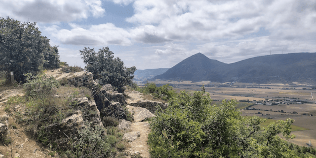
After arriving in the outskirts of the village of Elorz (2.6km), I turned right, heading uphill on another dirt track. Further up the hills, some maneuvering is needed to work around a private homestead that blocks the track, but it’s clear enough. Once you finally reach the ridgeline, you encounter the GR220 (2.5km). It’s a bit of work getting up to the tip-top, but the views of the valley are fantastic along the walk that follows.
Finally, turn right (5km) to descend along a footpath running alongside a fence. This is the lone part of the walk that was a little overgrown and a little rough, but fine on the whole. A couple quick turns follow at the bottom, but you’re still moving mostly in a straight line into the village of Tajonar (1.5km). Continuing generally in a straight line, I passed through the village, onto a minor highway, and then I turned right in a roundabout intersection with the NA-2310, into an industrial park (1km).
A footpath picks up from the back of that small complex, called the Paseo Elorz-Sadar. This largely follows the river into Pamplona. It’s a very pleasant walk, even if it’s an admittedly windy approach. You can shave off a bit of distance by following the highway, but I wouldn’t recommend it–you’re stuck following a busy, industrial road if you do that.
I stuck with the footpath 5km, until I finally turned right onto Avenida de Zaragoza, heading north. That still left me with a little over 2km of city walking, en route to the cathedral, but it was enjoyable enough, as a change of pace from everything preceding it.
All told, it was just 23.4km from Monreal to Pamplona, with the vast majority of that coming on unpaved terrain. I thought it worked pretty well! It’s a good option to consider if you’re just walking the Camino Aragonés and need to head home afterward. Even if you plan to walk the Camino Francés, I think this is worth considering–you still get to see Pamplona and don’t add that much distance to your trip.
I won’t go into the same detail on the remainder of my walk towards the Camino del Norte, but here’s a quick snapshot. From Pamplona, I followed the Camino Baztán in reverse 51km to Elizondo. The waymarking alone was mostly ok, but there was one extended stretch through the woods where I was very happy to have gpx tracks to help me through. In Elizondo, I joined the GR11, walking 30km onward to Bera. The ascent out of Elizondo was steep, but once I made it up to the top it was a very pleasant walk through the Pyrenees. I especially enjoyed my lunch at the Col de Lizarrieta, right on the border between France and Spain. Finally, from Bera to Irún I followed a bike path on the south/west side of the Bidasoa River most of the way–flat, easy, quiet walking.
After starting in Auch, France and walking through Lourdes, I then rejoined the GR653 south of Oloron-Sainte-Marie, which leads to Somport Pass and feeds directly into the Camino Aragonés. The weather was much more conducive to a great walk this time around, and I thoroughly enjoyed the walking, the towns and villages, and some fantastic hospitality. At a time when many were bemoaning the pilgrim traffic on the Camino Francés, the Aragonés was only lightly dotted with walkers.
The Camino Aragonés merges with the Camino Francés just before Puente La Reina, passing first through Eunate, which is a detour for many from the Francés. However, that wasn’t my plan on this trip. Instead, I wanted to head over to the Camino del Norte, and I wanted–of course–to make that transition on foot.
The first step in that process was getting from the Camino Aragonés to Pamplona. The most straightforward way to do that would be to join the Francés and then backtrack. I didn’t want to do that; it seemed like unnecessary kilometers, if a more direct option was on the table. And after doing some quick route-finding work, it proved that there was indeed a viable direct approach. I’ve uploaded the gpx track here.
Here’s what I did: 2km after Monreal, the Camino Aragonés comes fairly close to the A21 expressway. At that point, I turned right then left to join the NA-2420 highway. When I hit a roundabout further on, I turned right and passed under the expressway. After passing through another roundabout, I turned left onto a dirt track. That 1.5km stretch is the worst part of this walk.
After arriving in the outskirts of the village of Elorz (2.6km), I turned right, heading uphill on another dirt track. Further up the hills, some maneuvering is needed to work around a private homestead that blocks the track, but it’s clear enough. Once you finally reach the ridgeline, you encounter the GR220 (2.5km). It’s a bit of work getting up to the tip-top, but the views of the valley are fantastic along the walk that follows.
Finally, turn right (5km) to descend along a footpath running alongside a fence. This is the lone part of the walk that was a little overgrown and a little rough, but fine on the whole. A couple quick turns follow at the bottom, but you’re still moving mostly in a straight line into the village of Tajonar (1.5km). Continuing generally in a straight line, I passed through the village, onto a minor highway, and then I turned right in a roundabout intersection with the NA-2310, into an industrial park (1km).
A footpath picks up from the back of that small complex, called the Paseo Elorz-Sadar. This largely follows the river into Pamplona. It’s a very pleasant walk, even if it’s an admittedly windy approach. You can shave off a bit of distance by following the highway, but I wouldn’t recommend it–you’re stuck following a busy, industrial road if you do that.
I stuck with the footpath 5km, until I finally turned right onto Avenida de Zaragoza, heading north. That still left me with a little over 2km of city walking, en route to the cathedral, but it was enjoyable enough, as a change of pace from everything preceding it.
All told, it was just 23.4km from Monreal to Pamplona, with the vast majority of that coming on unpaved terrain. I thought it worked pretty well! It’s a good option to consider if you’re just walking the Camino Aragonés and need to head home afterward. Even if you plan to walk the Camino Francés, I think this is worth considering–you still get to see Pamplona and don’t add that much distance to your trip.
I won’t go into the same detail on the remainder of my walk towards the Camino del Norte, but here’s a quick snapshot. From Pamplona, I followed the Camino Baztán in reverse 51km to Elizondo. The waymarking alone was mostly ok, but there was one extended stretch through the woods where I was very happy to have gpx tracks to help me through. In Elizondo, I joined the GR11, walking 30km onward to Bera. The ascent out of Elizondo was steep, but once I made it up to the top it was a very pleasant walk through the Pyrenees. I especially enjoyed my lunch at the Col de Lizarrieta, right on the border between France and Spain. Finally, from Bera to Irún I followed a bike path on the south/west side of the Bidasoa River most of the way–flat, easy, quiet walking.

 . I did similar, but connected Pamplona with the Foz de Lumbier (a variant of the Aragon) by following the abandoned railway route of the first electric train in Europe! These alternative routes are a great way to maintain a walking pilgrimage when switching routes.


