mick53
Member
- Time of past OR future Camino
- Geira y Arrieiros, Torres 2023
Carol and I walked from Almeria to Merida in April this year (2023). A fantastic Camino with an amazing Friends group in Almeria to help you along your way. We have walked around 14 different caminos and this is now my favourite.
They even personally meet with you and give you your credentials as well as managing a group of Albergues on the way to Granada.
This is their Website...
http://www.caminomozarabesantiago.com/?m=0
Mercedes and Nely are amazingly helpful. Both are on WhatsApp which is commonly used in Spain - see their website for the mobile numbers.
Gronze is now a good site for all the Mozarabe ways from Almeria, Jaén, and Malaga as it now has the Almeria to Granada accommodation.
You could write a book (and people have so I won't!) on why the Mozarabe is a great Camino so I will just list some of the things that appeal to me:
- it is in Andalucia and Exremaduria which have some of the best Roman and Arab architectures and influences in Spain
- you get the beautiful coastal city of Almeria which is not overrun with tourists like Malaga
- you visit the fantastic cities of Granada and Cordoba and end in the Roman Architecture wonderland of Merida.
- in the early stages you walk the beautiful Sierra Nevada mountains surrounded by snow covered mountains peaks.
It is relatively undiscovered and not overrun with walkers so the locals are genuinely glad to see you and are very helpful. In one month the most walkers we saw or heard of was about 8-10, many days we met none, and only met 6 walkers while actually walking.
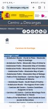
The most accurate kml paths were from the cnig site ( see photo).Gronze Maps were pretty useless e.g did not work offline.... We found while other kml/gpx paths were generally pretty good only the cnig site had the correct path in a few crucial places.
I used Organic maps for navigation .... from the developers of Maps.Me. Signage is generally good and from Almeria to Granada where it's done by Mercedes and her Friends Team it is excellent. You can load the paths from the cnig site easily into Organic Nsps.
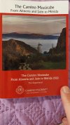
I also recommend buying the very cheap, up to date and compact guidebook ... it fitted in my pocket... from the CJC site in UK (see photo).
And, remember to use Chrome as your browser to auto-translate to your preferred language.
Below is from a post I did on the Geira de Arrioros Camino re Navigation.
---------------------------------------
These days you should ensure you have an App with the path for your Camino.
Even on the popular Caminos where you usually just have to "follow the crowd" it makes finding your accommodation easier, and if there is a problem you can find the shortest way to a village, road, pharmacy, etc.
You may not be where you want to be but you should never be lost!
For the Torres and Geira y Arrieiros an App is essential as you cannot rely on the signs.
At least the Geira information is honest, they tell you to take an App. Both walks provide official kml and gpx paths for your favourite apps, and if you search you can find others.
I use a combination of:
- Organic Maps as my main App to ensure I stay on path
- Google Maps in a town if I want to find extra services, opening times etc
- AllTrails to track my distance walked and elevation data e.g.how far I have climbed up
Organic Maps is free, has no adverts, once maps are downloaded it works fully in Flight Mode, and it works for Apple and Android phones. It was released by the original developers of Maps.Me. I previously used Maps.Me.
It will find you a walking, cycling or driving path between any 2 points, and for the walking and cycling paths it will show you an reasonably good profile and distance up and down. If you don't like it's path or want to follow a Camino path you have loaded you can add numerous mandatory 'stops' to align its path as you want.
Very handy for finding shortcuts and comparing them. Great if you are tired, the path is too muddy/wet etc.
You can add 'bookmarks' on bars, places of interest etc and share them if you wish.
It also has many service categories you can search for, e.g.food, accommodation, ATM etc - but not as many as Google Maps.
It accepts kml and kmz path files and can load them automatically when you open the file in your Android smartphone ... only an extra step required for Apple phones. Files in gpx format can easily be converted to kml.
Google Maps has comprehensive information on services you may want, will try and tell you opening hours provide contact details, link to websites etc. It will give you a driving but not a walking path and really needs internet data access to work.in map mode.
On a Camino I only use it in towns if I need something Organic Maps does not have. I have found it useful even in the small villages the Torres and Geira venture into.
AllTrails is a commercial App with lots of already loaded tracks and the ability to record your walk if you like, share it etc.
It has the full Torres and Geira y Arrieiros paths available, and can alert you if you wonder too far from the track. I only used it to record my distance walked, height climbed, and my track.
So always take an App you are familiar with and load it with your Camino path.
They even personally meet with you and give you your credentials as well as managing a group of Albergues on the way to Granada.
This is their Website...
http://www.caminomozarabesantiago.com/?m=0
Mercedes and Nely are amazingly helpful. Both are on WhatsApp which is commonly used in Spain - see their website for the mobile numbers.
Gronze is now a good site for all the Mozarabe ways from Almeria, Jaén, and Malaga as it now has the Almeria to Granada accommodation.
You could write a book (and people have so I won't!) on why the Mozarabe is a great Camino so I will just list some of the things that appeal to me:
- it is in Andalucia and Exremaduria which have some of the best Roman and Arab architectures and influences in Spain
- you get the beautiful coastal city of Almeria which is not overrun with tourists like Malaga
- you visit the fantastic cities of Granada and Cordoba and end in the Roman Architecture wonderland of Merida.
- in the early stages you walk the beautiful Sierra Nevada mountains surrounded by snow covered mountains peaks.
It is relatively undiscovered and not overrun with walkers so the locals are genuinely glad to see you and are very helpful. In one month the most walkers we saw or heard of was about 8-10, many days we met none, and only met 6 walkers while actually walking.
The most accurate kml paths were from the cnig site ( see photo).Gronze Maps were pretty useless e.g did not work offline.... We found while other kml/gpx paths were generally pretty good only the cnig site had the correct path in a few crucial places.
I used Organic maps for navigation .... from the developers of Maps.Me. Signage is generally good and from Almeria to Granada where it's done by Mercedes and her Friends Team it is excellent. You can load the paths from the cnig site easily into Organic Nsps.
I also recommend buying the very cheap, up to date and compact guidebook ... it fitted in my pocket... from the CJC site in UK (see photo).
And, remember to use Chrome as your browser to auto-translate to your preferred language.
Below is from a post I did on the Geira de Arrioros Camino re Navigation.
---------------------------------------
These days you should ensure you have an App with the path for your Camino.
Even on the popular Caminos where you usually just have to "follow the crowd" it makes finding your accommodation easier, and if there is a problem you can find the shortest way to a village, road, pharmacy, etc.
You may not be where you want to be but you should never be lost!
For the Torres and Geira y Arrieiros an App is essential as you cannot rely on the signs.
At least the Geira information is honest, they tell you to take an App. Both walks provide official kml and gpx paths for your favourite apps, and if you search you can find others.
I use a combination of:
- Organic Maps as my main App to ensure I stay on path
- Google Maps in a town if I want to find extra services, opening times etc
- AllTrails to track my distance walked and elevation data e.g.how far I have climbed up
Organic Maps is free, has no adverts, once maps are downloaded it works fully in Flight Mode, and it works for Apple and Android phones. It was released by the original developers of Maps.Me. I previously used Maps.Me.
It will find you a walking, cycling or driving path between any 2 points, and for the walking and cycling paths it will show you an reasonably good profile and distance up and down. If you don't like it's path or want to follow a Camino path you have loaded you can add numerous mandatory 'stops' to align its path as you want.
Very handy for finding shortcuts and comparing them. Great if you are tired, the path is too muddy/wet etc.
You can add 'bookmarks' on bars, places of interest etc and share them if you wish.
It also has many service categories you can search for, e.g.food, accommodation, ATM etc - but not as many as Google Maps.
It accepts kml and kmz path files and can load them automatically when you open the file in your Android smartphone ... only an extra step required for Apple phones. Files in gpx format can easily be converted to kml.
Google Maps has comprehensive information on services you may want, will try and tell you opening hours provide contact details, link to websites etc. It will give you a driving but not a walking path and really needs internet data access to work.in map mode.
On a Camino I only use it in towns if I need something Organic Maps does not have. I have found it useful even in the small villages the Torres and Geira venture into.
AllTrails is a commercial App with lots of already loaded tracks and the ability to record your walk if you like, share it etc.
It has the full Torres and Geira y Arrieiros paths available, and can alert you if you wonder too far from the track. I only used it to record my distance walked, height climbed, and my track.
So always take an App you are familiar with and load it with your Camino path.