• For 2024 Pilgrims: €50,- donation = 1 year with no ads on the forum + 90% off any 2024 Guide. More here.
    (Discount code sent to you by Private Message after your donation)
  • ⚠️ Emergency contact in Spain - Dial 112 and AlertCops app. More on this here.

Search 69,459 Camino Questions

Alicante to Orito

DTCamino

Active Member
Time of past OR future Camino
Camino de Madrid 2023
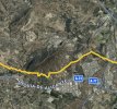
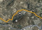
I’ve been comparing the route out of Alicante to Orito on the Buen Camino App vs the Wikiloc routes from RayYRosa and others and the Buen Camino App route seems more direct. Buen Camino turns on Calle Agemenon to go south of Fontcalent (mountain/ridge?) where the the Wikiloc routes go up to Camino de La Galera to go north of Fontcalent before heading west. See photos below.

Anyone use the Buen Camino App for this stretch and it worked well, or is there a reason for taking the longer Wikiloc routes?
IMG_7616.jpeg

IMG_7617.jpeg
 
3rd Edition. More content, training & pack guides avoid common mistakes, bed bugs etc
We followed the way marks. They were pretty consistent and clear and checked with wikiloc when we weren´t quite sure. Wikiloc seems to follow the way-marked camino so although it may be longer, I´d go with that.
 
In the spirit of giving unsolicited advice, I would also suggest that people take a look at a “mountain alternative” to start the Lana. We took a train from Alicante to Villajoyosa and had a few great days of ascent, great views, and good places to stay. We were inspired by Alan Sykes account. Some recent information here.

I recorded my wikiloc tracks for that alternative. The route merges with the “regular” Lana in Villena. Highly recommended!

Villajoyosa to Relleu, 20 km, 830 m elevation

Relleu to Torremanzanas, 20 km, 800 m elevation


Torremazanas to Onil, 28 km, 574 m elevation

 
3rd Edition. More content, training & pack guides avoid common mistakes, bed bugs etc
I’ve been comparing the route out of Alicante to Orito on the Buen Camino App vs the Wikiloc routes from RayYRosa and others and the Buen Camino App route seems more direct. Buen Camino turns on Calle Agemenon to go south of Fontcalent (mountain/ridge?) where the the Wikiloc routes go up to Camino de La Galera to go north of Fontcalent before heading west. See photos below.

Anyone use the Buen Camino App for this stretch and it worked well, or is there a reason for taking the longer Wikiloc routes?

View attachment 162468

View attachment 162469

North of the ridge Fontcalent is waymarked as the Camino. South of Fontcalent seems to be /part of/ the Senda del Poeta, a trail. There is a waymark pointing towards "La Senda del Poeta" at one point on the Camino. Earlier versions of the guide (Spanish guide from the Asociación) mentioned that you shouldn't follow it because it is not the Camino (it doesn't go through Orito). But it seems as if La Senda del Poeta reconnects with the Camino after Fontcalent judging by your pictures.

Here is a Wikiloc of the trail Senda del poeta that seems to correspond with your first picture south of Fontcalent: https://es.wikiloc.com/rutas-senderismo/senda-del-poeta-orihuela-alicante-gr-125-2158498
Thank you.
When I get to the intersection where the turn for the Senda Del Poeta is, I’ll be taking a hard look at the route. After walking the Camino de Madrid and finding the best route wasn’t always following the arrows or the Buen Camino app, I’m beginning to develop an appreciation for other ways of walking the established routes. It seems sometimes the arrows are moved or placed by people who have other interests in mind.
You´ll have fun on the Lana then.
 
Get a spanish phone number with Airalo. eSim, so no physical SIM card. Easy to use app to add more funds if needed.
North of the ridge Fontcalent is waymarked as the Camino. South of Fontcalent seems to be /part of/ the Senda del Poeta, a trail. There is a waymark pointing towards "La Senda del Poeta" at one point on the Camino. Earlier versions of the guide (Spanish guide from the Asociación) mentioned that you shouldn't follow it because it is not the Camino (it doesn't go through Orito). But it seems as if La Senda del Poeta reconnects with the Camino after Fontcalent judging by your pictures.

Here is a Wikiloc of the trail Senda del poeta that seems to correspond with your first picture south of Fontcalent: https://es.wikiloc.com/rutas-senderismo/senda-del-poeta-orihuela-alicante-gr-125-2158498
I did a little more research and the route below Fontcalent is mentioned below in the first Alicante-Orito stage in Caminosantiago.org under the link below.


Also the day before I walk it appears they are doing a walk the opposite way towards Alicante, on the Senda del Poeta to the cemetery on Alicante. Link is below for the walk.


❓How to ask a question

How to post a new question on the Camino Forum.

Forum Rules

Forum Rules

Camino Updates on YouTube

Camino Conversations

Most downloaded Resources

This site is run by Ivar at

in Santiago de Compostela.
This site participates in the Amazon Affiliate program, designed to provide a means for Ivar to earn fees by linking to Amazon
Official Camino Passport (Credential) | 2024 Camino Guides
Back
Top