• For 2024 Pilgrims: €50,- donation = 1 year with no ads on the forum + 90% off any 2024 Guide. More here.
    (Discount code sent to you by Private Message after your donation)
  • ⚠️ Emergency contact in Spain - Dial 112 and AlertCops app. More on this here.

Search 69,459 Camino Questions

Route from Vigo changed?

ElCee

Active Member
Time of past OR future Camino
Porto Sept 2023
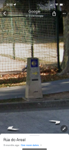
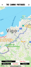
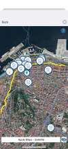
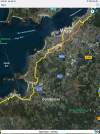
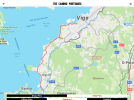
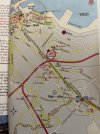
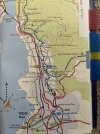
I’m seeing a lot of discussion on FB about the route out of Vigo. People are recommending taking a new bike path that starts at the Ascensor Halo and ends at Chapela because the official route is ugly, boring, or something. I don’t remember it being bad at all last fall so I pulled up my photos and tracks and Wise Pilgrim app. It looks perfectly fine from my photos. But the route now on Wise Pilgrim doesn’t seem to match what we walked. I even have a photo of the 102km marker that wouldn’t be on the route now mapped in Wise Pilgrim. And here it is on Google street view. Has the “official” route changed? On Wise Pilgrim it now goes around Vigo.
 

Attachments

  • IMG_4589.jpeg
    IMG_4589.jpeg
    2.8 MB · Views: 961
  • IMG_4591.png
    IMG_4591.png
    4.6 MB · Views: 25
  • IMG_4592.png
    IMG_4592.png
    1.3 MB · Views: 35
Get a spanish phone number with Airalo. eSim, so no physical SIM card. Easy to use app to add more funds if needed.
Interesting. I don't go on FB unless an emergency, so can't cross-ref there.
On Mapy.cz outdoor map I can see a cycle route from the station Vigo Urzaiz. It seems to run beside a small railway track and initially beside the autostrada (which can't be very nice) then beside the Avenida de Galicia. It's much closer to the bay than the official camino. But I liked the official route, quiet, trafficless back roads through sleepy suburbs with great views over the bay. At Teis one of our group branched off and took the GR94 through the hills to Redondela and very much enjoyed it.
 
I just walked this yesterday and saw the 102 km marker. I was staying in the area close to the cathedral and the Buen Camino app had a route that went right by the Cathedral and out of the city, up a steep hill or two and then into the forest. After the hill, I thought it was lovely!
 
Down bag (90/10 duvet) of 700 fills with 180 g (6.34 ounces) of filling. Mummy-shaped structure, ideal when you are looking for lightness with great heating performance.

€149,-
I just walked this yesterday and saw the 102 km marker. I was staying in the area close to the cathedral and the Buen Camino app had a route that went right by the Cathedral and out of the city, up a steep hill or two and then into the forest. After the hill, I thought it was lovely!
Could you post a screenshot of the route through Vigo in Buen Camino? I know we followed wise pilgrim so when I opened it and saw no route through downtown Vigo I felt like I was losing my mind!
Interesting. I don't go on FB unless an emergency, so can't cross-ref there.
On Mapy.cz outdoor map I can see a cycle route from the station Vigo Urzaiz. It seems to run beside a small railway track and initially beside the autostrada (which can't be very nice) then beside the Avenida de Galicia. It's much closer to the bay than the official camino. But I liked the official route, quiet, trafficless back roads through sleepy suburbs with great views over the bay. At Teis one of our group branched off and took the GR94 through the hills to Redondela and very much enjoyed it.
In photos on FB the bike lane looks horrible to me. Totally sterile and removed from the city.
 
Here is a screen shot of the route that I took through town.
 

Attachments

  • IMG_6972.png
    IMG_6972.png
    5.2 MB · Views: 31
Could you post a screenshot of the route through Vigo in Buen Camino?

In photos on FB the bike lane looks horrible to me. Totally sterile and removed from the city.

It is my understanding that whatever historical route may have gone through Vigo has long been lost to development and therefore any Camino route is best taken as a suggestion.

The new route that is mentioned is the Via Verde or Greenway that begins on the south side Urzaiz rail station (the Halo is on the North Side) and follows the former rail bed out of Vigo to the former rail station in Chapela. Like most rail lines, there are no services directly on the path, hence your description “sterile and removed from the city.”

I walked a portion of the Via Verde last year and found it refreshing after navigating the poorly marked streets of Vigo. After the station at Chapela, you walk Ave de Vigo to Camino de Laxes to Carretera de San Vicente de Trasmaño to rejoin the Camino. Carretera de San Vicente is a short but extremely steep street headed up to the Camino.

Below maps are the Junta de Galicia, Buen Camino and Wise Pilgrim. Last year, Wise Pilgrim did show the red dotted line though Vigo on roughly the same route as Buen Camino.
 

Attachments

  • IMG_0214.png
    IMG_0214.png
    1.3 MB · Views: 22
  • IMG_0213.png
    IMG_0213.png
    7.2 MB · Views: 14
  • IMG_0212.png
    IMG_0212.png
    1.6 MB · Views: 18
Join our full-service guided tour of the Basque Country and let us pamper you!
As you walk on the right side of the road past the central tree lined plaza in Vigo, you'll pass some urban shops and will see a yellow arrow painted on a wall directing you to the right and up some steep hills into some residential area. Great views from up there and eventually the path takes you into some wooded areas as you progress towards Redondela. I have heard another option is to follow the train tracks out of town but have no experience with that route.
 
It is my understanding that whatever historical route may have gone through Vigo has long been lost to development and therefore any Camino route is best taken as a suggestion.

The new route that is mentioned is the Via Verde or Greenway that begins on the south side Urzaiz rail station (the Halo is on the North Side) and follows the former rail bed out of Vigo to the former rail station in Chapela. Like most rail lines, there are no services directly on the path, hence your description “sterile and removed from the city.”

I walked a portion of the Via Verde last year and found it refreshing after navigating the poorly marked streets of Vigo. After the station at Chapela, you walk Ave de Vigo to Camino de Laxes to Carretera de San Vicente de Trasmaño to rejoin the Camino. Carretera de San Vicente is a short but extremely steep street headed up to the Camino.

Below maps are the Junta de Galicia, Buen Camino and Wise Pilgrim. Last year, Wise Pilgrim did show the red dotted line though Vigo on roughly the same route as Buen Camino.
I have actually studied this in some detail. Because we are starting from Vigo and then doing the Espiritial Varient and several other minor detours to add some km. If you look at the Vigo map photo, (pg 247 in Camino Portuguese-Brierley) you will see a dotted line going straight out from the port area/the cathedral.That street is Rua Principe (pedestrian street) and becomes Rua Urzaiz. From The cathedral “Vigo - Baja” to Vigo Alta is 2.1km uphill. This is where they measure the starting point - Vigo Alta Cruse. Passes by the Inglesia de los Picos to Rua Toledo, etc coffee shop O Chato near there, etc etc It isn’t difficult - at least doesn’t appear so. Will let you know next Tuesday! (We arrived in Porto this AM)
 

Attachments

  • image.jpg
    image.jpg
    2.1 MB · Views: 5
  • image.jpg
    image.jpg
    2.1 MB · Views: 4
The focus is on reducing the risk of failure through being well prepared. 2nd ed.
<snip>Will let you know next Tuesday! (We arrived in Porto this AM)
I’d be super interested in your experience as I’ve been studying the route into and out of Vigo for what seems like ages now. This stage has consumed most of my planning effort so far 😅

We are walking from Baiona that day and have found a Vigo accommodation option on a street just off Rua Urzaiz, near the intersection with Rua Toledo. Hopefully this means we will be able to get underway to Redondela without too much faff the next day.

Bom Caminho!
Sounds like you found a perfect accommodation! Buen Camino
 

Most read last week in this forum

Another wonderful walking day! Definitely feeling it in my legs today- a few more stretch breaks needed! And lots of wonderful places to take them! Theme for the day boardwalks! Received a few...

❓How to ask a question

How to post a new question on the Camino Forum.

Forum Rules

Forum Rules

Camino Updates on YouTube

Camino Conversations

Most downloaded Resources

This site is run by Ivar at

in Santiago de Compostela.
This site participates in the Amazon Affiliate program, designed to provide a means for Ivar to earn fees by linking to Amazon
Official Camino Passport (Credential) | 2024 Camino Guides
Back
Top