• For 2024 Pilgrims: €50,- donation = 1 year with no ads on the forum + 90% off any 2024 Guide. More here.
    (Discount code sent to you by Private Message after your donation)
  • ⚠️ Emergency contact in Spain - Dial 112 and AlertCops app. More on this here.

Search 69,459 Camino Questions

Alternate route after Castro Urdiales

Anne Mclennan

Member
Time of past OR future Camino
2009 Camino Portuguese
2018 Camino Frances
Hi all
I’ve read there’s a coastal alternative from Pontarron de Guriezo ( after Castro Urdiales). I see it in the wise pilgrim book but there’s no alternate shown on the app. Any ideas about this route? Is it well marked? Is it worthwhile?
And how far would it be from Castro to:
A) Liendo ?
B) Laredo ??
 
Join our full-service guided tour and let us convert you into a Pampered Pilgrim!
Well, there is an unofficial route along the cliffs of Pico Solpico that goes along the coast without having to go through Pontarron, by crossing the beach at Oriñon. It is approximately 22 km to Laredo. During my camino Norte reverse (Santander-Irun) in May I had planned to walk there (coming from Laredo) following this Wikiloc file.

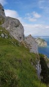
But when I saw the height of the mountain and the steep cliffs, I didn't dare to go and went around the mountain to get to Playa Valdearenas beach instead. Some pilgrims I met told me that it's obviously a dangerous path along the cliff, even requiring the use of a rope attached at one point.

Also, as I have learned, it is only possible to walk across Oriñon beach at low tide. In order to get to the next bridge I had to make the 8 km detour to Pontarron. In the end I walked 35 km that day and reached my hostel in Castro-Urdiales at 21:30, very exhausted.
Thank you that is great information
 
Down bag (90/10 duvet) of 700 fills with 180 g (6.34 ounces) of filling. Mummy-shaped structure, ideal when you are looking for lightness with great heating performance.

€149,-
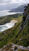
After I shared my walk on the beach route with my family, my son asked if he should take out a life insurance policy on me. Haha. That said, it's pretty challenging with narrow paths, rough terrain, and steep grades but with care I made it. The walk on the beach was wonderful.
 
After my recent Camino, I learned of a coastal route from Liendo to Laredo. It is shown on Buen Camino, which I did not check that day; it is not shown on the apps/maps that I did check. A video that I saw after I returned home discussed it but didn't mention any dangers. I am very curious about it because my wife and I walked along the N-634 west of Liendo/Hazas and I found it to be one of the scariest parts of Camino del Norte. Can anybody shed any light on the difficulty of the coastal route that starts around Villanueva?
 
Join our full-service guided tour of the Basque Country and let us pamper you!
After my recent Camino, I learned of a coastal route from Liendo to Laredo. It is shown on Buen Camino, which I did not check that day; it is not shown on the apps/maps that I did check. A video that I saw after I returned home discussed it but didn't mention any dangers. I am very curious about it because my wife and I walked along the N-634 west of Liendo/Hazas and I found it to be one of the scariest parts of Camino del Norte. Can anybody shed any light on the difficulty of the coastal route that starts around Villanueva?
A year ago 5 of us did this coastal variant. We’d previously stayed at Ontón, lunch at Islares, that night at Oriñon. Next morning, a perfect day, good forecast, we walked the trail to the headland but instead of traversing round and through the notch, we went up to the left at a fork and onto a nice natural platform about half way up, then another fairly easy scramble up to the rim of Pico Solpico, 480m, glorious views, raptors and the extraordinary Los Ojos del Diablo rock arches. One of our party was using Komoot the German trail app for navigation. Completely reliable. Spent a couple of hours up there walking the ridges and across a crater like basin to the west side and down a quite steep section onto a vehicle track. Track was pretty well defined all the way. Sure it’s not for the faint hearted and you need to be fit and competent and respect the mountain, but it’s well travelled. We met 2 others hiking it on the day. We made lunch at Villanueva and stayed the night at Santoña. It was the formation of this Camino family (none of us had met more than 3 days earlier), and we went on to SdC and Fisterre together more or less. One of the best bits of hiking I’ve done.
 
A year ago 5 of us did this coastal variant. We’d previously stayed at Ontón, lunch at Islares, that night at Oriñon. Next morning, a perfect day, good forecast, we walked the trail to the headland but instead of traversing round and through the notch, we went up to the left at a fork and onto a nice natural platform about half way up, then another fairly easy scramble up to the rim of Pico Solpico, 480m, glorious views, raptors and the extraordinary Los Ojos del Diablo rock arches. One of our party was using Komoot the German trail app for navigation. Completely reliable. Spent a couple of hours up there walking the ridges and across a crater like basin to the west side and down a quite steep section onto a vehicle track. Track was pretty well defined all the way. Sure it’s not for the faint hearted and you need to be fit and competent and respect the mountain, but it’s well travelled. We met 2 others hiking it on the day. We made lunch at Villanueva and stayed the night at Santoña. It was the formation of this Camino family (none of us had met more than 3 days earlier), and we went on to SdC and Fisterre together more or less. One of the best bits of hiking I’ve done.
I should have explained from Oriñon the trail goes to Sonabia, across the back (south) of the playa Sonabia and then angles up to the headland. The fork up to the left is before reaching the point.
 
After my recent Camino, I learned of a coastal route from Liendo to Laredo. It is shown on Buen Camino, which I did not check that day; it is not shown on the apps/maps that I did check. A video that I saw after I returned home discussed it but didn't mention any dangers. I am very curious about it because my wife and I walked along the N-634 west of Liendo/Hazas and I found it to be one of the scariest parts of Camino del Norte. Can anybody shed any light on the difficulty of the coastal route that starts around Villanueva?

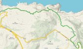
I think you mean the coastal alternative AFTER the mountain Pico Solpico, which gronze has marked as "senda costera" here. (The mountain is located where the compass is on that map).
It is indeed very picturesque and not difficult.
 
Last edited:
Get a spanish phone number with Airalo. eSim, so no physical SIM card. Easy to use app to add more funds if needed.
I walked this section last month (Mid May 2023). We stayed on the N-634 From Pontarron as far as Isequilla. This was a mixture of paths behind the barrier, or 1-2 m space between the white line and the barrier. While I have not walked it before, I got the impression that some work had been done to provide additional sections of path behind the barrier where possible.
We turned off the main road at Isequilla and took back lanes to Villanueva, but you could continue on the N-634 for a bit more. We then turned up a steep paved road as far as Playa de San Julián, where it continued as a gravel / dirt road. The section after the lookout point was a single file dirt track through bracken and gorse and heather. It was uneven underfoot with tree roots and stones to navigate, so you needed to watch your footing but it was not technically difficult.
Some of our group had continued along the N-634 to Laredo and got there 30 minutes before us, but the four of us who went by the headland all agreed it was well worth the effort and the detour to see the fabulous views.Villanueva - Laredo.jpg
 
After my recent Camino, I learned of a coastal route from Liendo to Laredo. It is shown on Buen Camino, which I did not check that day; it is not shown on the apps/maps that I did check. A video that I saw after I returned home discussed it but didn't mention any dangers. I am very curious about it because my wife and I walked along the N-634 west of Liendo/Hazas and I found it to be one of the scariest parts of Camino del Norte. Can anybody shed any light on the difficulty of the coastal route that starts around Villanueva?
Completely agree with your feelings about the N634 section from Liendo to Laredo. The coastal variant you are asking about is very nice. Some ups and downs but there is a good path, no need to scramble over rocks. In my opinion it is without a doubt preferable to walking along N634. You can find a map on mapy.cz ( a great resource for Norte coastal variants) as well as Buen Camino.
 

Most read last week in this forum

I use Alltrails a lot here in the US, in Iceland, on the Via Podiensis and a bit on the CF. Will it be useful on the Norte? For example, people here say the "warm up" from Biarritz to Irun (or...
Last May I walked the first part of the Norte in the opposite direction, from Santander to Irun. Since I only had two weeks and couldn't reach Santiago anyway, I wanted to swim against the tide...
Tomorrow I fly to Bilbao to start my 5th stint on the Camino. I did the Frances in three parts (2016, 2017 and 2022). Last year I did the Portuguese from Porto. I did the first 200 km of the...
I thought I had this all figured out, but I have ended up with 2 train tickets from San Sebastian (I don't even know if it's the airport or the town) to Irun, instead of ONE that goes all the way...
Hi! I’m a Camino newbie planning on walking Camino del Norte this May-June. I have previous hiking experience and do well on longer distances and so on, but not any super recent multi day long...
I’m on day 2 of the CDN and I’m just blown away by the views. Day 1 Irun to San Sebastián, day 2 San Sebastián to Askizu Buen Camino

❓How to ask a question

How to post a new question on the Camino Forum.

Similar threads

Forum Rules

Forum Rules

Camino Updates on YouTube

Camino Conversations

Most downloaded Resources

This site is run by Ivar at

in Santiago de Compostela.
This site participates in the Amazon Affiliate program, designed to provide a means for Ivar to earn fees by linking to Amazon
Official Camino Passport (Credential) | 2024 Camino Guides
Back
Top