• Get your Camino Frances Guidebook here.
  • For 2024 Pilgrims: €50,- donation = 1 year with no ads on the forum + 90% off any 2024 Guide. More here.
    (Discount code sent to you by Private Message after your donation)
  • ⚠️ Emergency contact in Spain - Dial 112 and AlertCops app. More on this here.

Search 69,459 Camino Questions

Exploring Pena dos Corvos on Camino Francés

Bert45

Veteran Member
Time of past OR future Camino
2003, 2014, 2016, 2016, 2018, 2019
Have you heard of Pena dos Corvos? It is supposed to be a high point (660m) before Portomarin. Google Maps can find four Penas dos Corvos on the north coast of Galicia, but not on the CF. A lot of the camino references are suspiciously similar:
The Camino ascends to a high point at Pena dos Corvos; at 660m you will enjoy panoramic views, (Macs Adventure), (Second Life Outdoors) and (Bergfex)
The. Camino ascends to a high point at Pena dos Corvos. At 660m, we will enjoy fantastic panoramic views (Nativity Pilgrimage)
We reach the high point of the day at Pena dos Corvos (660m)! (Pathfinders.me)
Pena dos Corvos 660m at Cruce Momientos [1.3 km] with fine views (Brierley) -- Google Maps doesn't know where Cruce Momientos is either.
Pity of the Crows is the translation from Galician -- seems an odd name to give to a place, but something may have been lost in translation. I don't expect that there is a sign saying "Pena dos Corvos", but, if there isn't, how did all these bloggers know that they were there? So, can you give me the co-ordinates for Pena dos Corvos on the Camino Francés?
 
Last edited:
Ideal sleeping bag liner whether we want to add a thermal plus to our bag, or if we want to use it alone to sleep in shelters or hostels. Thanks to its mummy shape, it adapts perfectly to our body.

€46,-
This appears on the map as a location after Portomarín.

What is wanted are the exact coordinates of a spot on a Pena dos Corvos before Portomarín.

It is peña in Spanish and pena in Galician. In the given context peña means craggy mountain or hill - it is entry #2 in the RAE. It must be a popular name for field names. The village where I grew up, far away from Galicia, has an area of fields called Ravens Hill.
 
Last edited:
Down bag (90/10 duvet) of 700 fills with 180 g (6.34 ounces) of filling. Mummy-shaped structure, ideal when you are looking for lightness with great heating performance.

€149,-
Transport luggage-passengers.
From airports to SJPP
Luggage from SJPP to Roncevalles
A lot of the camino references are suspiciously similar:
The Camino ascends to a high point at Pena dos Corvos; at 660m you will enjoy panoramic views, (Macs Adventure), (Second Life Outdoors) and (Bergfex)
The. Camino ascends to a high point at Pena dos Corvos. At 660m, we will enjoy fantastic panoramic views (Nativity Pilgrimage)
We reach the high point of the day at Pena dos Corvos (660m)! (Pathfinders.me)
Pena dos Corvos 660m at Cruce Momientos [1.3 km] with fine views (Brierley) -- Google Maps doesn't know where Cruce Momientos is either.
My thought is that possibly many of these comments are from tour groups, whose participants, in addition to walking portions of the Camino also have van/buses that shuttle them to impressive spots along the way to "enhance" their experience.
 
This appears on the map as a location after Portomarín.

What is wanted are the exact coordinates of a spot on a Peña dos Corvos before Portomarín.

It is peña and not pena. In the given context peña means craggy mountain or hill - it is entry #2 in the RAE. It must be a popular name for field names. The village where I grew up, far away from Galicia, has an area of fields called Ravens Hill.
Ah misread, or probably so excited I thought I knew where it was!
 
So, the high point in that stage is here:
Screenshot_20240225-132600.png
However, this seems to be misleading as according to this: https://www.rayyrosa.com/camino-frances/sarria/portomarin the place you talk of is here somewhere:

Screenshot_20240225-133317~2.png

Now I took a lot of photos and I don't have any amazing views from here even though our weather was ok. Maybe you had to leave the path to reach the viewpoint. And even in Google satellite it's difficult to pick anything out that looks like a viewpoint.
 
New Original Camino Gear Designed Especially with The Modern Peregrino In Mind!
With IGN's Mapas de España app I see a high spot of 665 meters marked to the east of A Pena where the CF meets a triangle of land surrounded by roads. Pretty much at the center of this map. BTW, this is between Sarria and Portomarin.

Screenshot_20240225-091248.png

Also pretty much here at the Albergue-Restauante Casa Cruceiro de Ferreiros:

Edit: The following edit was written without seeing posts 8 and 9 below.

To the west of A Pena IGN shows the CF crossing the 660 m contour at Marcadoiro (also seen as Mercadoiro). Google Maps shows a spot marked as Cruceiro just before it. Could this be Cruce Momientos?
 
Last edited:
@davejsy, you don't give up easily :cool:
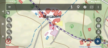
. It is the second screenshot in your post. It's not necessarily the highest point on the CF in the area, just a high point with a good wide view. Both the hill and the cross are marked on maps.
 
I wonder if "Cruce Momientos" refers to Cruceiro, a junction marked by a cross, about 100 meters west of Moimentos.

A Pena is about 500 meters west of Mirallos. The path rises to about 660 meters elevation at this point, just east of Mirallos.

If you are looking for an elevated panoramic view, a detour to the right just before the bus stop at O Couto through A Pedreira and Castrelo, rejoining the official path near Moutras (adds 0.2 km). Might be a nice break from the herd. ;)

Hope this helps.

Cruce Momientos
 
Last edited:
Join our full-service guided tour and let us convert you into a Pampered Pilgrim!
Sorry folks. I had been making unmarked edits to my post #7 above because, for some reason, I hadn't been seeing a note that the software gives you that new posts have been arriving. Some of my comments were made without seeing posts #8 and #9.
 
Thanks, Everyone. What bothers me is, if Peña dos Corvos is not marked on any map, and there is no signpost saying "Peña dos Corvos 660m" (as there is at many other highpoints, like "Alto do Poio altitud 1.335 m"), how did anybody, including the great Brierley (RIP), find out or realise that that was where they were?
 
Thanks, Everyone. What bothers me is, if Peña dos Corvos is not marked on any map, and there is no signpost saying "Peña dos Corvos 660m" (as there is at many other highpoints, like "Alto do Poio altitud 1.335 m"), how did anybody, including the great Brierley (RIP), find out or realise that that was where they were?
I'm not sure it's something that should cause any bother. Maybe it is marked when you get there if your looking. It is odd though that they all mention it and it's not obvious.
 
Technical backpack for day trips with backpack cover and internal compartment for the hydration bladder. Ideal daypack for excursions where we need a medium capacity backpack. The back with Air Flow System creates large air channels that will keep our back as cool as possible.

€83,-
Thanks, Everyone. What bothers me is, if Peña dos Corvos is not marked on any map, and there is no signpost saying "Peña dos Corvos 660m" (as there is at many other highpoints, like "Alto do Poio altitud 1.335 m"), how did anybody, including the great Brierley (RIP), find out or realise that that was where they were?
Oral tradition is a possibility.
 
I can see that there is a great danger that one misses the good views between Rozas and Moimentos on the Camino Francés in Galicia when one has not read about it beforehand in a guidebook or a blog and when there is no sign on the hill that tells the pilgrim to stop here in this very spot and admire or photograph the view.

How did the words Pena dos Corvos get into Brierley and other books or blogs in the first place? It was probably copied from other guidebooks and descriptions of the area. And perhaps a local of As Rozas once said to a traveller: "Don't take the road to the left, take the road to the right up the Pena dos Corvos and by the way there's a good view up there." And then the traveller wrote it down and shared the information with future travellers. I am assuming of course that the conversation was held in Spanish or in Galego and not in English and that the information got translated later.

Get hold of decent maps and see where this Pena dos Corvos area is. On a detailed enough topographic map one can also see where the trail to Santiago touches the 640 m altitude line.

Or one just walks and thinks, great view, I must be on the Pena dos Corvos hill now. :cool:

A Pena dos Corvos.jpg
 
Last edited:
Edited here to remove a quote, paragraph and map.

How did the words Peña dos Corvos get into Brierley and other books or blogs in the first place? It was probably copied from other guidebooks and descriptions of the area. And perhaps a local of As Rozas once said to a traveller: "Don't take the road to the left, take the road to the right up the Peña dos Corvos

Maybe Peña dos Corvos was the prior name of a bar.
 

Attachments

  • Screenshot_20240225-123134.png
    Screenshot_20240225-123134.png
    1.1 MB · Views: 22
Last edited:
The 9th edition the Lightfoot Guide will let you complete the journey your way.
I can see that there is a great danger that one misses the good views between Rozas and Moimentos on the Camino Francés in Galicia when one has not read about it beforehand in a guidebook or a blog and when there is no sign on the hill that tells the pilgrim to stop here in this very spot and admire or photograph the view.

How did the words Peña dos Corvos get into Brierley and other books or blogs in the first place? It was probably copied from other guidebooks and descriptions of the area. And perhaps a local of As Rozas once said to a traveller: "Don't take the road to the left, take the road to the right up the Peña dos Corvos and by the way there's a good view up there." And then the traveller wrote it down and shared the information with future travellers. I am assuming of course that the conversation was held in Spanish or in Galego and not in English and that the information got translated later.

Get hold of decent maps and see where this Peña dos Corvos area is. On a detailed enough topographic map one can also see where the trail to Santiago touches the 640 m altitude line.

Or one just walks and thinks, great view, I must be on the Peña dos Corvos hill now. :cool:

View attachment 164977
Yes this definitely makes sense as that is the spot I thought it must be on the old 3D google earth thing (camino is the yellow line). 1708885208453.png
 
I now believe the spot Brierley mentioned is here. It is near the cruce (road crossings) of the village named Momientos, the view opens up, and the Camino starts heading downhill. Besides, look at viewpoint/mirador marked on Brierley's map (west at the top of the page).

IGN's app shows the elevation to be 580 m though, not 660. Brierley the cartographer may have used someone else's value instead of getting the value from an IGN topographic map.


PXL_20240225_185055051.jpg
 
Last edited:
A selection of Camino Jewellery
I now believe the spot Brierley mentioned is here. It is near the cruce (road crossings) of the village named Momientos, the view opens up, and the Camino starts heading downhill. Besides, look at viewpoint/mirador marked on Brierley's map (west at the top of the page).


View attachment 164985
It makes sense, but other accounts give the location before you cross the road and before Momientos.
 
how did all these bloggers know that they were there?
They copied each other, going back in history to the explanation given by @Kathar1na:
How did the words Peña dos Corvos get into Brierley and other books or blogs in the first place? It was probably copied from other guidebooks and descriptions of the area. And perhaps a local of As Rozas once said to a traveller: "Don't take the road to the left, take the road to the right up the Peña dos Corvos and by the way there's a good view up there." And then the traveller wrote it down and shared the information with future travellers.
Exactly!!

seems an odd name to give to a place
Stop for a moment and look at a map - even with English place names. Many many stranger names exist! We just get used to them and the strangeness fades. How about "Moose Jaw"?
 
Technical backpack for day trips with backpack cover and internal compartment for the hydration bladder. Ideal daypack for excursions where we need a medium capacity backpack. The back with Air Flow System creates large air channels that will keep our back as cool as possible.

€83,-
In Galician is " Pena dos Corvos" . In Spanish would be " Peña de los Cuervos".
Thank you so much! This is very reassuring to read, coming from a Galician who is not struggling with Galician and Spanish vocabulary and toponomy like I and quite a few others among us are struggling. 😀
 
Last edited:
Who or what is the source of Brierley's map? It is not conventional, having north to the right, but it is obviously a professional job. It introduces a bit more confusion, which doesn't matter (much!). But, if the map is correct, we have Peña do Cervo, which Google Translates as "Stag's Rock", so nothing to do with crows. But it gives Momientos, which accounts for Brierley's version, where everyone else calls Moimentos. It's only a transposition of two letters, but it confuses Google Maps. If Brierley was using that map, where did he get Pena dos Corvos from? Is there any reliable source that can say if the place is called Peña do Cervo or Peña dos Corvos. I know this won't matter to most people, and tbh, it doesn't matter very much to me.
 
Very light, comfortable and compressible poncho. Specially designed for protection against water for any activity.

Our Atmospheric H30 poncho offers lightness and waterproofness. Easily compressible and made with our Waterproof fabric, its heat-sealed interior seams guarantee its waterproofness. Includes carrying bag.

€60,-
Who or what is the source of Brierley's map? It is not conventional, having north to the right, but it is obviously a professional job. It introduces a bit more confusion, which doesn't matter (much!). But, if the map is correct, we have Peña do Cervo, which Google Translates as "Stag's Rock", so nothing to do with crows. But it gives Momientos, which accounts for Brierley's version, where everyone else calls Moimentos. It's only a transposition of two letters, but it confuses Google Maps. If Brierley was using that map, where did he get Pena dos Corvos from? Is there any reliable source that can say if the place is called Peña do Cervo or Peña dos Corvos. I know this won't matter to most people, and tbh, it doesn't matter very much to me.
I think like most things Camino related the only way you will find it is to walk it.
 
Who or what is the source of Brierley's map? It is not conventional, having north to the right, but it is obviously a professional job.
Obviously, Brierley had a professional graphics person prepare an attractive map for publication. That doesn't mean that he did historical research into the place names and different cultural perspectives on every place. He was writing a pilgrim's guide from his own perspective, observations and casual research, and he never claimed to be an authoritative source for geographic or historical information.
it doesn't matter very much to me.
The various answers that are proposed in this thread will only add to the lore (aka confusion) of the place names.
 
I found Crow Cliff, aka Penedo do Corvo. It is just a bit south of the clearing I mentioned earlier and appears on this map above the grey block with the white 84 in it.

Screenshot_20240225-143225.png
 
The 2024 Camino guides will be coming out little by little. Here is a collection of the ones that are out so far.
Brierley adjusts his maps so the longer part of the page is used to display the most interesting part of the camino, its length. We aren't so much interested in the parts of Spain we aren't going to walk in so those areas are displayed in the narrow part of the page. This gives us the most information that we want onto the page. Then the compass is added later.
 
Last edited:
Who or what is the source of Brierley's map? It is not conventional, having north to the right, but it is obviously a professional job. It introduces a bit more confusion, which doesn't matter (much!). But, if the map is correct, we have Peña do Cervo, which Google Translates as "Stag's Rock", so nothing to do with crows.
Seriously now? We try to find out why Brierley's map and book has yet another minuscule inaccuracy or ambiguity :cool:? When we have online access to an up to date map, created on behalf of the Xunta of Galicia and with the cooperation of the Real Academia Galega that lets us consult the toponomy of Galicia with 557.373 topónimos recompilados?

This interactive detailed map shows us that there is an area between As Rozas and Moimentos that is near the Camino de Santiago and that is called Pena dos Corvos in Galego (see post #14) and another area nearby that is called Pena do Cervo in Galego (see below). I don't know their Spanish names (if they exist and are different).

As to the crosses along the Camino de Santiago in the Rozas-Moimentos area, I join @davejsy and would suggest to walk it and see how many there are and then try to figure out why they are not all on Goggle maps. I will reveal only that there are more than one - or at least that in 2011 there were more than one because I've viewed the photos. Nothing to write home about though in my humble opinion. :cool:

Cervo.jpg
 
Last edited:
In Galician is "Pena dos Corvos". In Spanish would be "Peña de los Cuervos".

I've now corrected my typing errors in previous posts. Google Translate is often quite poor when it translates from Galician and Deepl.com which is much better does not offer Galician to English translations. Also, unlike Deepl.com, Google Translate does not offer the whole range of different meanings that a word can have, another serious disadvantage.
 
3rd Edition. More content, training & pack guides avoid common mistakes, bed bugs etc
I've looked at Streetview where Brierley put a panorama symbol, and there's nothing there to justify "enjoy panoramic views" and even less to justify "fantastic panoramic views" (imo). I also went back up the road to what appeared to be the highest point just before Moimentos (going back from the Cruce) or just after Moimentos (walking westward) and the views from there are no better (again imo). Remember my quotations in post #1 do not mention leaving the camino to climb a hill or do anything but follow the yellow arrows. You can get panoramic views almost anywhere on the camino, so long as there are no houses or trees close by. I'd like to call a halt to this question, if I may.
 
@Bert45, are you at least using Google Earth or merely Google Maps and Streetview? There is only so much that you can visualise online. You will either have to walk from As Rozas to Portomarín to check or you will have to accept that written descriptions are inaccurate and even contradictory, and that includes the Brierley guide.

The Brierley guidebook and its maps serve their purpose: it gets people to Santiago. But it is a guidebook that prints O Cebreiro as O'Cebreiro and Moimentos as Momientos, and nobody has bothered to correct such obvious errors because they don't matter much for the foreign Camino pilgrim.

In Google Earth, you can see the elevation of any location. The top of the hill identified in post #14 as Pena dos Corvos has an elevation of 670 m when the pointer hovers over it. The Camino trail that goes along this hill has an elevation of 645 m in this very area. There are great views there, people have photographed them. The location is not on StreetView.

The tiny village of Moimentos shows an elevation of 585 m in Google Earth. A cross marked as Cruceiro, about 200 m further along the Camino trail, has an elevation of 565 m. It is around there that you have a lovely view of the white church of A Laxe to the left and further down. I don't take many photos but I took a photo of this very nice view of the white church among all the green. A view that is worth marking on a map. But it is not the view that others describe earlier when passing Pena dos Corvos.

You need to walk it again. Buen Camino!
 
Last edited:
This interactive detailed map shows us that there is an area between As Rozas and Moimentos that is near the Camino de Santiago and that is called Pena dos Corvos in Galego (see post #14) and another area nearby that is called Pena do Cervo in Galego (see below). I don't know their Spanish names (if they exist and are different).
The Spanish names are Las Rozas ( As Rozas), ? (Moimentos) and Peña del Ciervo ( Pena do Cervo).
 
St James' Way - Self-guided 4-7 day Walking Packages, Reading to Southampton, 110 kms
Pena dos Corvos 660m at Cruce Momientos [1.3 km] with fine views (Brierley)
@Bert45, I don't know whether you noticed it when you typed your introduction. I noticed it only when I saw @Rick of Rick and Peg 's copy of Brierley's map and when I finally decided to pull out my own copy of Brierley (copyrighted in 2015). While he writes Pena dos Corvos 660 m in his text, he marks Peña do Cervo in his map, and he makes it look like this were a single spot on the Camino trail while it is in reality about an extended hill and two different hills with their own names.

No wonder an attentive reader might get confused. And the author seems to be confused himself, both about the names and locations of the hills and the names and locations of the crosses in the area. As I said already, this does not really matter for his walking readers. They will find their way from As Rozas to Moimentos just fine. I am so glad that we have cleared up this confusion. I don't think that it would have been possible without a proper map that is a map in the conventional sense and not a Brierley map. Summing up:

The Penas do Cervo (which is the correct name and not Brierley's "Peña do Cervo") is a largish hill that extends on its western side down to Moimento, as its contour lines show. It is nearly 700 m high.

The Pena dos Corvos is a smaller hill with a height of 660 m. From the Camino trail, one could easily walk up to the top, it is just a few extra metres to walk, and it is 20 m higher than the trail - that is church tower height, and like so many church towers it is likely to provide a good all-round view.

There is, or was, a cross very near the Pena dos Corvos. The name is Cruz do Chao. There is a cross much further away from these two hills, namely 200 m after Moimento but it is already at a considerably lower elevation level.

With thanks to the excellent Visor de Topónimos de Galicia:
Visualisation of the extension of the Penas do Cervo between As Rozas and Moimentos, and location of Penas do Cervo and Pena dos Corvos:
Penas do Cervo.jpg

Visualisation of the location of the Cruz do Chao just south of the Pena dos Corvos:
Cruz do Chao.jpg
 
Last edited:
The Spanish names are Las Rozas ( As Rozas), ? (Moimentos) and Peña del Ciervo ( Pena do Cervo).
Thanks again. I nearly asked you what accidentes terrestres are. I just could not figure it out. The interactive map that I consulted displays accidentes terrestres, terras and entidades humanas. But I found out in the meantime that it means landforms and that makes a lot more sense in the given context than terrestrial accidents. 😊
 
Thanks again. I nearly asked you what accidentes terrestres are. I just could not figure it out. The interactive map that I consulted displays accidentes terrestres, terras and entidades humanas. But I found out in the meantime that it means landforms and that makes a lot more sense in the given context than terrestrial accidents. 😊
Yes, more common for this is "accidentes geográficos" ( or xeográficos in Gal.).
 
3rd Edition. More content, training & pack guides avoid common mistakes, bed bugs etc
Well, well, well, the things you can find when you explore. Someone took a photo ten years ago. You need to look carefully and closely at the photo. Then you will make out the words on this old mojon:

Pena
dos Corvos

The pilgrim who took the photo comments with these words: llegando al mojón del Km.96, el de "Pena dos Corvos" - arrival at waymarker 96 km, the one of the Pena dos Corvos.

Mojon PdC.jpg
http://caminosdelsur5.blogspot.com/2013/07/por-el-buen-camino-de-ponferrada.html
 
Last edited:
And just for fun, from the same website, the 90 km waymarker near Portomarín. I did not know that the old Galician waymarkers, now replaced, had placenames on them. And in red! 😊

View attachment 165030
Thanks Kathar1na, and other posters, for your work researching this topic. It is so interesting and gives us a new unmarked landform to discover and enjoy searching for. I think I have picnicked there in the past. Now I can pay closer attention walking to confirm.
 
Very light, comfortable and compressible poncho. Specially designed for protection against water for any activity.

Our Atmospheric H30 poncho offers lightness and waterproofness. Easily compressible and made with our Waterproof fabric, its heat-sealed interior seams guarantee its waterproofness. Includes carrying bag.

€60,-
Exploring Pena dos Corvos on Camino Francés

Okay, let's. I got the approximate coordinates for the place the Galician website had for the Peña dos Corvos and asked Flickr to show pictures taken nearby. BTW, thank you @Kathar1na for mentioning that website.

 
@Bert45, are you at least using Google Earth or merely Google Maps and Streetview? There is only so much that you can visualise online. You will either have to walk from As Rozas to Portomarín to check or you will have to accept that written descriptions are inaccurate and even contradictory, and that includes the Brierley guide.

The Brierley guidebook and its maps serve their purpose: it gets people to Santiago. But it is a guidebook that prints O Cebreiro as O'Cebreiro and Moimentos as Momientos, and nobody has bothered to correct such obvious errors because they don't matter much for the foreign Camino pilgrim.

In Google Earth, you can see the elevation of any location. The top of the hill identified in post #14 as Pena dos Corvos has an elevation of 670 m when the pointer hovers over it. The Camino trail that goes along this hill has an elevation of 645 m in this very area. There are great views there, people have photographed them. The location is not on StreetView.

The tiny village of Moimentos shows an elevation of 585 m in Google Earth. A cross marked as Cruceiro, about 200 m further along the Camino trail, has an elevation of 565 m. It is around there that you have a lovely view of the white church of A Laxe to the left and further down. I don't take many photos but I took a photo of this very nice view of the white church among all the green. A view that is worth marking on a map. But it is not the view that others describe earlier when passing Pena dos Corvos.

You need to walk it again. Buen Camino!
Thanks for all your efforts, Kathar1na. I really appreciate it. I have not been using Google Earth, just Streetview. I don't believe that you can get a view from near ground level with GE. When you get close to the ground it switches to Streetview. Even Streetview consists of photos taken from above the roof of a car, so it isn't quite the same as the view from the average person's height, but pretty close. I began this thread partly because I was intrigued by the obvious copy and paste that some people had used, and the fact that, in five caminos (2003, 2014, 2016, 2019, 2022) I have never been so overwhelmed by the view that I felt compelled to take a photo. Then, more OCD curiosity over the name and GM's inability to find it. I am still confused as to the actual name in Galician or in Spanish. Pelegrin wrote: The Spanish names are Las Rozas ( As Rozas), ? (Moimentos) and Peña del Ciervo ( Pena do Cervo). Pena (galego), peña (Spanish), that's OK, but is it cervo/ciervo or corvos/cuervos or corvo/cuervo? The Spanish don't seem to distinguish between ravens and crows, according to my small dictionary.
I took a photo of that 90 km mojón by the bridge over the Minho (Miño)! In mine it is inscribed "If Roland can do it ..."
I was unable to use that Topónimos site, as I am functionally illiterate in computer, galego and Spanish.
I am walking the camino again in June/July. I shall be keeping my eyes open for panoramic views from Morgade to Portomarín. (Well, from SJPdP to SdC, really.)
THANKS to all contributors! Yoju have excelled yourselves. Next question ....
 
The one from Galicia (the round) and the one from Castilla & Leon. Individually numbered and made by the same people that make the ones you see on your walk.
I was unable to use that Topónimos site, as I am functionally illiterate in computer, galego and Spanish.
I can handle a bit of Spanish and I'm pretty good at figuring out websites but this website was a bit tricky but I spent an hour with it and I think I've got a handle on it now. I couldn't use it on my phone and Peg had way too many tabs up on her browser and that hid tabs I ended up creating so that didn't help.

Thanks again for showing us that site @Kathar1na.

I am still confused as to the actual name in Galician or in Spanish. Pelegrin wrote: The Spanish names are Las Rozas ( As Rozas), ? (Moimentos) and Peña del Ciervo ( Pena do Cervo). Pena (galego), peña (Spanish), that's OK, but is it cervo/ciervo or corvos/cuervos or corvo/cuervo?
Yesterday on the Topónimos site I searched the Paradela locality for the sole word corvo and it found and pinned two places. One was the spot just off the camino that @Kathar1na has shown us twice in two different ways. The site had the name A pena dos Corvos. I had Google Translate translate the name from Gallego and pena was coming out as pain, pity, penalty and sorrow depending on how much I typed. Changing pena to peña it presented me with foot or rock. Rock makes sense. @Pelegrin has already told us that it is not peña in Gallego but pena is correct. Has Goog messed up?

I've noticed before that peña seems to have different translations for different regions in Spain: rock, crag, cliff or overhang. (At at fiesta in Sahagún I found it also meant club. Each club had a different colored shirt for its members).

Interesting was seeing that the base map that I used in post #27 there was a Penedo do corvo marked near the pinned location (A pena dos corvos) while @Kathar1na's post #29 had a base map with a Penas do cervo nearby the pinned location but in a different place than the Penedo do corvo.
 
The one from Galicia (the round) and the one from Castilla & Leon. Individually numbered and made by the same people that make the ones you see on your walk.
As I mentioned already, as someone who can read Spanish quite well but lacks the vocabulary of a native speaker and who can decipher Galician to some extent because of the similarity of words with Portuguese and with Spanish, I, too, struggled with the meaning of pena and peña in both Spanish and Galician.

A reliable source are monolingual dictionaries, in this case the RAE. It provides 6 different meanings for (Spanish) peña:
  1. Piedra grande sin labrar, según la produce la naturaleza (A large unworked stone, as produced by nature).
  2. Monte o cerro peñascoso (A rocky mountain or rocky hill).
  3. Corro o grupo de amigos o camaradas (A circle or group of friends or comrades.
  4. Círculo de recreo (A recreational circle).
  5. Grupo de personas que participan conjuntamente en fiestas populares o en actividades diversas, como apostar, jugar a la lotería, cultivar una afición, fomentar la admiración a un personaje o equipo deportivo, etc. (A group of people who participate together in popular festivities or in various activities, such as gambling, playing the lottery, cultivating a hobby, encouraging admiration for a sports character or team, etc.)
  6. ant. Piel para forro o guarnición (old - Leather for lining or trimming).
In the given context, it is obviously number 2.

I am mentioning this because this may be more helpful for future quests than a small Spanish-English dictionary. When you already know that you have to look for a rocky hill you may find it easier than when you think that the word means pity.

There is another thing that one needs to pay attention to: the tilde sign. In Spanish, peña and pena (which has 9 different meanings in the RAE) do not denote the same things. To complicate things further, while Spanish uses two words - peña and pena - the Galician language uses only pena to denote all these different things / concepts.

It is therefore all the more annoying that the writers / editors of the Brierley guidebook and others do not pay attention to this when they print the names of towns, rivers, hills and mountain ranges in their publications.
 
Last edited:
BTW, that a mountain is called a stone is not surprising for those of us who have walked in the Alps: Waxenstein, Nebelstein, Wetterstein, Dachstein, Hexenstein, Krähenstein - the list seems endless.

A search in the web app for local names in Galicia shows that there are 23 landforms or agricultural land that are called Pena dos Corvos. And 136 of them with Corvos in their name. And 358 search results with Corvo in their name. Google Maps knows a lot but they don't know everything. ;)

Now we have given a lot of exposure to an inconspicuous hill that most of us will not even notice when we walk past. It may have a good panoramic view but that may be more interesting for locals who can pick out features ("look, there is Paradela and over there is the Loio river and is that the reservoir?") than for us who may or may not enjoy just another good view.
 
Last edited:
Yes, in Spanish " pena" means pity and "peña" means rock. In Galego " pena" means rock and also pity. Therefore the albergue "Alto da pena" in Negreira ( C. Fisterra) could be confusing for a Spanish speaker who reads "Stop, gives pity". "Penedo" ( Gal) is "peñasco" (Sp). Portuguese is the same as Galego for this.
 
Technical backpack for day trips with backpack cover and internal compartment for the hydration bladder. Ideal daypack for excursions where we need a medium capacity backpack. The back with Air Flow System creates large air channels that will keep our back as cool as possible.

€83,-
I have no idea how this (see below) got onto my computer and I don't know where I saw it. It marks the viewpoint near the hill, i.e. the location on the Camino Francès, shortly after the village As Rozas, that we have now successfully identified. It is well before the spot marked on the Brierley "map". I will share the screenshot before I delete it on again my computer. 😊

It looks like an extract from the Michelin booklet of Camino Francès maps.

Anyway, I am pretty certain that the majority of those who describe the view from this spot, as quoted in the first post, have never set foot on this path. They are copywriters for niche travel agencies and content producers for websites who copy from each other. I would not take their word as gospel.

View.jpeg
PS: The blue line marks the Camino trail.​
 
Last edited:
Down bag (90/10 duvet) of 700 fills with 180 g (6.34 ounces) of filling. Mummy-shaped structure, ideal when you are looking for lightness with great heating performance.

€149,-
A better photo of the old waymarker K.96 than the photo in #37. It would be nice if the stone was still in place. And not defaced by some "Camino artist". I cropped this photo to cut out the nonsense that someone had smeared on it.

Hito Pena dos Corvos.jpg
 
Last edited:

Most read last week in this forum

Just an FYI that all available beds are taken in SJPDP tonight - fully, truly COMPLETO! There’s an indication of how busy this year may be since it’s just a Wednesday in late April, not usually...
Between Villafranca Montes de Oca and San Juan de Ortega there was a great resting place with benches, totem poles andvarious wooden art. A place of good vibes. It is now completely demolished...
Hi there - we are two 'older' women from Australia who will be walking the Camino in September and October 2025 - we are tempted by the companies that pre book accomodation and bag transfers but...
We have been travelling from Australia via Dubai and have been caught in the kaos in Dubai airport for over 3 days. Sleeping on the floor of the airport and finally Emerites put us up in...
Hi all, Very new to this so please excuse any ignorance or silly questions :) I'm walking my very first Camino in 2 weeks (iieeeek) - the countdown is on and excitement through the roof. I've...
From a friend on the ground in Pamplona https://www.noticiasdenavarra.com/fotos/general/sociedad/2024/04/23/nieve-primaveral-presente-navarra-8152386.html

❓How to ask a question

How to post a new question on the Camino Forum.

Forum Rules

Forum Rules

Camino Updates on YouTube

Camino Conversations

Most downloaded Resources

This site is run by Ivar at

in Santiago de Compostela.
This site participates in the Amazon Affiliate program, designed to provide a means for Ivar to earn fees by linking to Amazon
Official Camino Passport (Credential) | 2024 Camino Guides
Back
Top