• For 2024 Pilgrims: €50,- donation = 1 year with no ads on the forum + 90% off any 2024 Guide. More here.
    (Discount code sent to you by Private Message after your donation)
  • ⚠️ Emergency contact in Spain - Dial 112 and AlertCops app. More on this here.

Search 69,459 Camino Questions

Five Days on St. Olav's way SWEDEN

Jo Jo

Active Member
Time of past OR future Camino
Eight routes; nine pilgrimages 2014-present
This question is for anyone who has walked the St. Olav's way through Sweden: If you have just five days to walk, what is the nicest 5 days of walking on this route? Bonus points if there is public transportation on both ends.

A bit about us. My wife and I are experienced pilgrims in Spain, also with plenty of backpacking in the U.S. We are going to be in Sweden this summer for a birthday party. We have about a week to walk, and would like to do a section of St. Olav's way in Sweden (our flight back home is from Stockholm, so going to Norway does not make much sense).

Suggestions and thoughts much appreciated.

Buen Camino,
Jo Jo
 
Very light, comfortable and compressible poncho. Specially designed for protection against water for any activity.

Our Atmospheric H30 poncho offers lightness and waterproofness. Easily compressible and made with our Waterproof fabric, its heat-sealed interior seams guarantee its waterproofness. Includes carrying bag.

€60,-
The two shorter sections that come to mind for me are:
  • Skalstugen to Stiklestad, which I walked in three days, or perhaps start in Medstugen if that is more accessible and take four days. I would avoid the sections from Are to Medstugen, although there is a wonderful spot along the way at Tannforsen that would be a shame to miss. Otherwise, these have long stretches of roadside walking, that didn't otherwise offer much but the thrill of hoping you are seen by the oncoming traffic, light as that might be. Staying at Skalstugen is a delight, a bit expensive for one, might work better for two, but availability might be an issue.
  • Entirely within Sweden, walking from Borgsjo to Pilgrimstad (four days) would be my next pick, or any of that leg to Ostersund. I stayed at Garden Eriksberg, Revsunds Prestgard and Kvarnvagen 26 (just out of Pilgrimstad). These were all great places to stay along that section.
This site is a good resource.
Thank you, thank you.
 
Join our full-service guided tour and let us convert you into a Pampered Pilgrim!
This question is for anyone who has walked the St. Olav's way through Sweden: If you have just five days to walk, what is the nicest 5 days of walking on this route? Bonus points if there is public transportation on both ends.

A bit about us. My wife and I are experienced pilgrims in Spain, also with plenty of backpacking in the U.S. We are going to be in Sweden this summer for a birthday party. We have about a week to walk, and would like to do a section of St. Olav's way in Sweden (our flight back home is from Stockholm, so going to Norway does not make much sense).

Suggestions and thoughts much appreciated.

Buen Camino,
Jo Jo
I look forward to reading about your experience this summer, Jo Jo, since I am walking St. Olavsleden in August.
 
I look forward to reading about your experience this summer, Jo Jo, since I am walking St. Olavsleden in August.
Regrettably, a developing medical issue may make it impossible for us to walk this summer. It is looking very unlikely at this point. But I hope you have a great walk.
 
Regrettably, a developing medical issue may make it impossible for us to walk this summer. It is looking very unlikely at this point. But I hope you have a great walk.
I hope it will work out for you and become a reality, now or later, it's a very nice trip. Best wishes :)
 
The 9th edition the Lightfoot Guide will let you complete the journey your way.
Doug, we are looking at the Borgsjo to Pilgrimstad section. My health seems to have improved enough I can walk. How do you figure out distances on this route. Map and website have some distances, but do not allow to customize as near as I can tell.
 
Doug, we are looking at the Borgsjo to Pilgrimstad section. My health seems to have improved enough I can walk. How do you figure out distances on this route. Map and website have some distances, but do not allow to customize as near as I can tell.
I think you are right. I had a look at the Swedish site, and this one from the Norse Pilgrim Association. It seems to me that the planning tools have changed since I last used them. I couldn't find an easy way to determine intermediate distances, and on the Swedish site, the only distances available were for their pre-set stages. Looking at these, I didn't walk any of those from Borgsjo to Pilgrimstad as described. Either the 'daily' stages were too long for me, or I wanted to stay at places that were intermediate to the end points.

I suspect that the guidebook that I was using would have had more information about the distances between locations along the route. Unfortunately, I am in Europe for a few more weeks, and it isn't, so I cannot check to confirm this.
 
How do you figure out distances on this route.

Just dug out the old St. Olavsleden guidebook (2017 edition):

Borgsjö - Länsgränsen (21 km) 60% gravel roads, 40% trails/paths
Länsgränsen - Bräcke (20 km) 70% gravel, 15% trails/paths, 15% tarmac
Bräcke - Gällö (23 km) 60% tarmac, 35% gravel, 5% trails/paths
Gällö - Pilgrimstad (18 km) 50% gravel, 40% paths, 10% tarmac
 
A selection of Camino Jewellery
Just dug out the old St. Olavsleden guidebook (2017 edition):

Borgsjö - Länsgränsen (21 km) 60% gravel roads, 40% trails/paths
Länsgränsen - Bräcke (20 km) 70% gravel, 15% trails/paths, 15% tarmac
Bräcke - Gällö (23 km) 60% tarmac, 35% gravel, 5% trails/paths
Gällö - Pilgrimstad (18 km) 50% gravel, 40% paths, 10% tarmac
I stayed at:
  • Tatje lantgardhotell just after Borgsjo
  • Garden Ericksberg
  • Revsund Prastgard
  • Kvamvagen 26, on the outskirts of Pilgrimstad
I think there was somewhere else, but I won't be able to confirm that until I get back home at the end of the month. It might be that I walked a long day at some point instead.

They were all good places to stay, with wonderful hosts and great food. The quality of accommodation varied a little, but it was all comfortable, just in different ways.
 
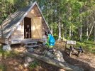
And if your legs are feeling good that first day out of Borgsjö, some 6 km after Länsgränsen there is a basic pilgrim shelter at Lake Stor-Harrsjön. You'd need a sleeping bag and mat, but it was a cheap alternative to spend the night.

shelter.jpg

Edit: another benefit on this part of the trail is that from Bräcke on you walk pretty much parallel to the train tracks. Up until Östersund you can use the train to your advantage.
 
Last edited:
Thank you for the information. Anyone have an opinion on whether we could walk this route backwards (west to east). Because of train schedules, it would be best for us to start in Ostersund and walk east for the few days we have. I can probably follow it east using GPX tracks, but is the signage such that it marks the route both ways (think the Portuguese Camino with the blue marks back to Fatima).
 
Down bag (90/10 duvet) of 700 fills with 180 g (6.34 ounces) of filling. Mummy-shaped structure, ideal when you are looking for lightness with great heating performance.

€149,-
is the signage such that it marks the route both ways

The guide states that "markings are positioned in the direction from Selanger to Trondheim". So you'll have to rely on your GPX tracks for the most part.
 
Thank you. I'm now drilling in further, and food options are looking a bit scarce in many places along the route. I.E., some places with accommodations are a long way from any cafe, and even if they have a kitchen, they seem to be long ways from any grocery store. Or are there more cafes/grocery stores than are marked on the website? How did you find the experience?
 
Very light, comfortable and compressible poncho. Specially designed for protection against water for any activity.

Our Atmospheric H30 poncho offers lightness and waterproofness. Easily compressible and made with our Waterproof fabric, its heat-sealed interior seams guarantee its waterproofness. Includes carrying bag.

€60,-
@Purky, I had forgotten you were doing the S.t Olavsleden shortly after me. That sounds horrible.

Getting back to @Jo Jo's question, I don't recall there being any particular difficulty on that section. Places I stayed were mostly always happy to provide a lunch pack when I asked for one, or there were some towns where one could have a heavy duty snack and replenish one's food bag. I only recall one section where I carried food for three days, and even that wasn't really necessary, and that was in a different section of the S.t Olavleden than @Jo Jo is considering.

On the earlier question of doing this section in reverse, I think it would be a mixed bag. The larger waymarking stakes and any hanging placards are generally easy to see going forwards, and they might still be reasonably visible going in the other direction. However, there are many waymarks about 25mm square on what I would call a gardening stake, and I found these difficult to see, and missed a few. I don't think they would be very helpful to someone doing the trail in reverse.
 
Thank you both. Very helpful. I don't think I'm walking backwards. I going to start in Ostersund and walk west for a five days (all we have time for this trip). My wife was just not into camping out in those shelters without running water (apparently, showers are an important spiritual element in her Caminos). BTW, I'm assuming that water is readily available as well. If not, let me know and I'll pack my backpacking (U.S. meaning of that term) water filter.
 

❓How to ask a question

How to post a new question on the Camino Forum.

Forum Rules

Forum Rules

Camino Updates on YouTube

Camino Conversations

Most downloaded Resources

This site is run by Ivar at

in Santiago de Compostela.
This site participates in the Amazon Affiliate program, designed to provide a means for Ivar to earn fees by linking to Amazon
Official Camino Passport (Credential) | 2024 Camino Guides
Back
Top