

- Time of past OR future Camino
- See signature
Like many others, I skipped the ugly and urban Lucca - Altopascio stage when I walked the Via Francigena last fall from Aosta. This spring, however, Sandy Brown, author of one of the leading guidebooks to the route, posted about a new alternative route on the VF Facebook page. Intrigued, I decided to try it out when in Lucca last week for some R&R after having walked the Via degli Dei.
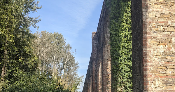
And it's terrific! Scenic, tranquil, and easily walked in one day, certainly the equal in beauty (and more peaceful) than most of the preceding stages between Pontremoli and Lucca. Starting from the train station in Lucca, it cuts ribbon-straight for 4 kilometers on a dirt path through a park in the shadow of a 19th Century aqueduct. At the end of the aqueduct, you enter into the woods and climb some 200 meters over the next 1.5 kilometers until you reach the ridge. For the next 5+ kilometers you may feel like you're back in the Apennines. Shaded hardwood forest, winding up and down (but not overly so), and with great vistas back towards Lucca and over the Alpi Apuane.
Once you get down, it's dead flat to Altopascio, but the trail remains serene and tranquil as you wind through a series of canals on rural paths where the only traffic is an occasional tractor. Unlike the Po Valley, though, there's some tree breaks and the surrounding hills provide a nice vista in the distance. You'll join up with the official route about 3 kilometers out of the center of Altopascio, and you'll be instantly glad to have avoided it.
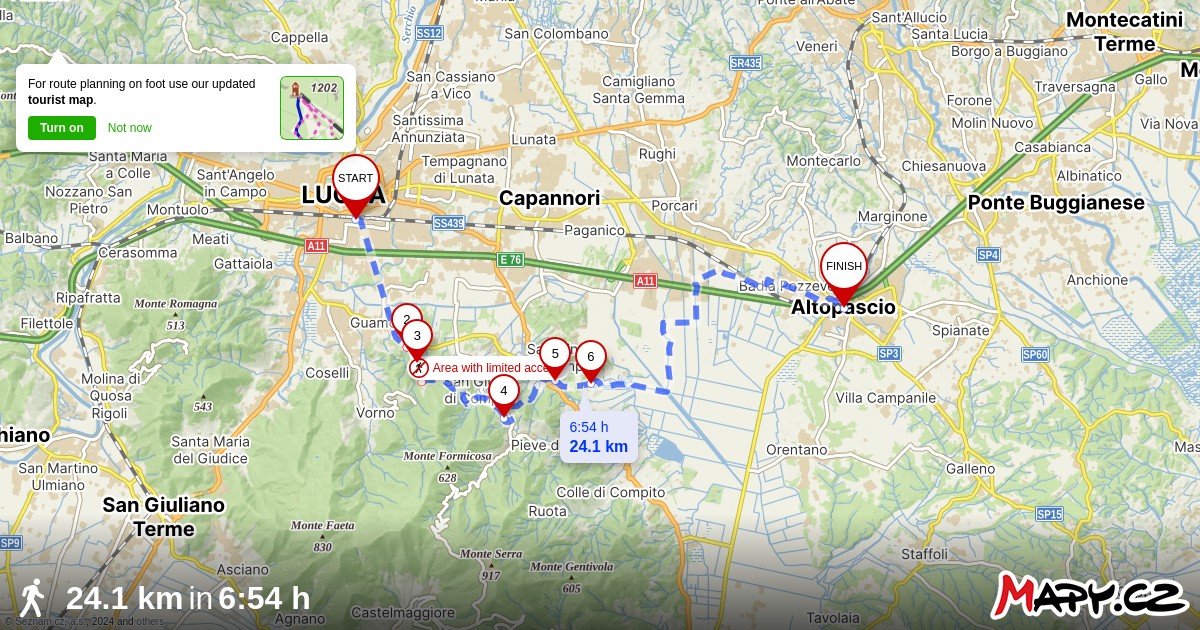
From the train station in Lucca to the church in downtown Altopascio, it's 24.1 kilometers / 15 miles, with an elevation gain (and loss) of 410 meters / 1345 feet. More than half of it is on dirt trails or paths, and I didn't see another walker all day. Except for some very very short stretches on a real road, I also encountered next to no cars until I joined up with the official route outside of Altopascio.
Here is the actual route I followed (with one exception, discussed below). It should open easily if you have Mapy.cz installed (and if you don't have it installed, you should!)
 en.mapy.cz
It also tracks the route Sandy Brown described, except that I found a peaceful side road which avoids 500 meters on the busy SS439. You can read Sandy Brown's Facebook post here: https://www.facebook.com/groups/19899007360/search/?q=sandy brown
Some notes follow:
1. For much of the way, this route is marked as a variant to the regular Via Francigena route. However, the "official" variant is approximately 40 kilometers and is not readily doable in one day. This alternative departs from the official one at the end of the aqueduct (it rejoins it later), so you should not follow any VF signs once you reach the end of the aqueduct until the point where you rejoin it, which will be obvious. Follow the gpx track instead.
2. The one part of the route I did not follow was from the end of the aqueduct to the ridge. This is because I approached the ridge from the little hamlet of Vorno to the west rather than from Lucca to the north. I did this because I wanted to shave off a few kilometers and because I assumed that the beginning of the route, as it headed out from Lucca, would be busy and urban. The next morning I walked the aqueduct part, and found out that it was totally tranquil -- if not quite as scenic as plunging into the woods and the climb right away. And it turned out that starting from Vorno only saved me 3 kilometers. But if starting from Vorno sounds more appealing, I can send you a track. It's reachable either by taxi, or by the E18 bus from central Lucca.
3. You'll find water fountains along the Aqueduct, and later, along the trail between San Giusto di Compito and Sant'Andrea di Compito.
4. I saw one open bar, off the trail to the right a little, about 1 k. after you cross the busy SS439.
5. If you open my track in Mapy.cz, you'll see some waymarks. Here's what they mean:
--- Start: The track starts from the south end of the Lucca train station. This is the side away from the city walls and the center of town. With your back to the train station, go left (east) and in 140 meters turn right onto Via del Tempietto. Almost immediately, you'll see the aqueduct.
--- 2 (and 3): This is the point where the track departs from the official alternative. The trail from here to the ridge crosses private property, but Sandy Brown said that it is open to walkers. The landowner only wants to bar cars and bikes. (If you find otherwise, you can stay on the official variant, and it will get you to the same place. It'll just take you an extra 600 meters).
--- 4: Just off to the right, you'll see the public fountain. And right before this point, you'll re-join the official, marked variant.
--- 5: This is where my track departs from Sandy Brown's, allowing you to avoid 500 meters on the busy SS439. When you get to the intersection with that road, follow it just a short way to the first intersection (Via Castel Durante). Turn left, and after less than 200 meters, you can turn right onto a broad dirt path which will run you right into the Via della Francese, where the (by now official) alternative continues to the left. It will be obvious.
--- 6. At this point, about 50 meters to the right along the intersecting Via di San Ginese, you'll find the one and only bar I saw. Personally, I would never count on any particular bar to be open, so carry some lunch.
--- End: At the Chiesa San Jacopo Maggiore, in the center of Altopascio.
Here's a link to some photos:
 photos.app.goo.gl
Happy trails, and a big thanks to Sandy Brown.
And it's terrific! Scenic, tranquil, and easily walked in one day, certainly the equal in beauty (and more peaceful) than most of the preceding stages between Pontremoli and Lucca. Starting from the train station in Lucca, it cuts ribbon-straight for 4 kilometers on a dirt path through a park in the shadow of a 19th Century aqueduct. At the end of the aqueduct, you enter into the woods and climb some 200 meters over the next 1.5 kilometers until you reach the ridge. For the next 5+ kilometers you may feel like you're back in the Apennines. Shaded hardwood forest, winding up and down (but not overly so), and with great vistas back towards Lucca and over the Alpi Apuane.
Once you get down, it's dead flat to Altopascio, but the trail remains serene and tranquil as you wind through a series of canals on rural paths where the only traffic is an occasional tractor. Unlike the Po Valley, though, there's some tree breaks and the surrounding hills provide a nice vista in the distance. You'll join up with the official route about 3 kilometers out of the center of Altopascio, and you'll be instantly glad to have avoided it.
From the train station in Lucca to the church in downtown Altopascio, it's 24.1 kilometers / 15 miles, with an elevation gain (and loss) of 410 meters / 1345 feet. More than half of it is on dirt trails or paths, and I didn't see another walker all day. Except for some very very short stretches on a real road, I also encountered next to no cars until I joined up with the official route outside of Altopascio.
Here is the actual route I followed (with one exception, discussed below). It should open easily if you have Mapy.cz installed (and if you don't have it installed, you should!)
Mapy.cz
NejpoužÃvanÄjÅ¡Ã mapový portál v ÄR s celou Åadou tématických map - základnÃ, turistickou, cyklistickou, dopravnà a plno dalÅ¡Ãch. NabÃzà možnost reálného leteckého, panoramatického nebo 3D pohledu. Rozsáhlé množstvà obsahu, firem a turistických bodů zájmu. UmožÅuje...
en.mapy.cz
It also tracks the route Sandy Brown described, except that I found a peaceful side road which avoids 500 meters on the busy SS439. You can read Sandy Brown's Facebook post here: https://www.facebook.com/groups/19899007360/search/?q=sandy brown
Some notes follow:
1. For much of the way, this route is marked as a variant to the regular Via Francigena route. However, the "official" variant is approximately 40 kilometers and is not readily doable in one day. This alternative departs from the official one at the end of the aqueduct (it rejoins it later), so you should not follow any VF signs once you reach the end of the aqueduct until the point where you rejoin it, which will be obvious. Follow the gpx track instead.
2. The one part of the route I did not follow was from the end of the aqueduct to the ridge. This is because I approached the ridge from the little hamlet of Vorno to the west rather than from Lucca to the north. I did this because I wanted to shave off a few kilometers and because I assumed that the beginning of the route, as it headed out from Lucca, would be busy and urban. The next morning I walked the aqueduct part, and found out that it was totally tranquil -- if not quite as scenic as plunging into the woods and the climb right away. And it turned out that starting from Vorno only saved me 3 kilometers. But if starting from Vorno sounds more appealing, I can send you a track. It's reachable either by taxi, or by the E18 bus from central Lucca.
3. You'll find water fountains along the Aqueduct, and later, along the trail between San Giusto di Compito and Sant'Andrea di Compito.
4. I saw one open bar, off the trail to the right a little, about 1 k. after you cross the busy SS439.
5. If you open my track in Mapy.cz, you'll see some waymarks. Here's what they mean:
--- Start: The track starts from the south end of the Lucca train station. This is the side away from the city walls and the center of town. With your back to the train station, go left (east) and in 140 meters turn right onto Via del Tempietto. Almost immediately, you'll see the aqueduct.
--- 2 (and 3): This is the point where the track departs from the official alternative. The trail from here to the ridge crosses private property, but Sandy Brown said that it is open to walkers. The landowner only wants to bar cars and bikes. (If you find otherwise, you can stay on the official variant, and it will get you to the same place. It'll just take you an extra 600 meters).
--- 4: Just off to the right, you'll see the public fountain. And right before this point, you'll re-join the official, marked variant.
--- 5: This is where my track departs from Sandy Brown's, allowing you to avoid 500 meters on the busy SS439. When you get to the intersection with that road, follow it just a short way to the first intersection (Via Castel Durante). Turn left, and after less than 200 meters, you can turn right onto a broad dirt path which will run you right into the Via della Francese, where the (by now official) alternative continues to the left. It will be obvious.
--- 6. At this point, about 50 meters to the right along the intersecting Via di San Ginese, you'll find the one and only bar I saw. Personally, I would never count on any particular bar to be open, so carry some lunch.
--- End: At the Chiesa San Jacopo Maggiore, in the center of Altopascio.
Here's a link to some photos:
7 new items by Andy Cohn
photos.app.goo.gl
Happy trails, and a big thanks to Sandy Brown.
Last edited:


