Ender just sent me a picture of an arrow that some pilgrims followed yesterday and wound up getting lost in the mountains. This is not an official Camino marking. Do not follow it!
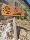
Some details. In the town of Boñar, there are two options. One is up through the mountains to Vegacervera. It is well marked. It is referred to as stage 13 B on the official website. The other option, also well marked, stays low and goes from Boñar to La Robla. It is referred to as 13 A.
The 13 A option passes through the town of Aviados where there is a private albergue. The 13 B option does not go through that town. At some point on the 13B route, someone has put this sign directing pilgrims to Aviados.
If you take that turn off and manage to get yourself to Aviados, you will find that you are not on the route to Vegacervera but rather back on the route to La Robla. Even worse, if you get lost, you’re out in the mountains somewhere.
Ender is heading out to see what he can do, which will probably involve ripping out the sign, but he will go to Aviados and see what’s going on. But he wanted me to post this heads up in case there are people heading out and who might take the turn off.


 although that was quite fun back then (high school Duke of Edinburgh expeditions)