Search 69,459 Camino Questions

Avoiding Ponferrada - linking the CF with the Invierno

sun is shining

Active Member
Dear all,

I've read here/somewhere a few people mentioning an alternative start to the Invierno by splitting off from the CF before Ponferrada. My tentative plan is to stay the night in Riego de Ambrós - connect to the Invierno - stay in Villavieja. Looking purely at Google maps this variant looks nice, certainly nicer than walking through the city.

Am I imagining it that people are doing this? I could swear that I've read about it here on the forum but I cannot find the corresponding threads anymore. Any insight would be much appreciated! Oh, we have a GPS so navigation away from the yellow arrows for a stage shouldn't be a problem. Thank you!
 
The focus is on reducing the risk of failure through being well prepared. 2nd ed.
I would just make sure you have a place to stock up before Villavieja. As I understand it, no services there although a good kitchen. Also you used to have to contact the city office in another community during business hours in advance for the albergue code as it is unmanned. Others can confirm.
 
Yes, the albergue in Villavieja is unmanned. I contacted the number given in Gronze.com a few days before I was due there and in the reply I was given the code for the door. It was just as well because I had no mobile coverage while there and would have been unable to contact the number given on the door. Bring food as there is nothing in the village. The albergue itself is beautiful, clean and modern. Buen Camino!
 
New Original Camino Gear Designed Especially with The Modern Peregrino In Mind!
I've read here/somewhere a few people mentioning an alternative start to the Invierno by splitting off from the CF before Ponferrada.

I think you are talking about the Valle de Silencio. There is a beautiful trail from Riego de Ambrós called the Puentes de Malpaso. It avoids the rocky descent into Molinaseca but it will take you either to Molinaseca or Ponferrada. I am not aware of a trail that goes from Riego directly to Villavieja and avoiding Ponferrada, but I would love to learn about it. So if you have more info, let me know.

The best suggestion I can come up with based on walking around that area on two occasions is to consider leaving the CF earlier, in El Acebo, going down through the Roman forge and then onto Peñalba de Santiago (my tracks here, it’s 21 km)and then a further 6km to Monastery of Montes de Valdueza where there is an albergue. (When I walked this route, there was lodging in Peñalba de Santiago, which is a beautiful little village, incredibly well preserved with a mozarabic church. That lodging is no longer available, so you would have to go on 6 more km to Valdueza. That trail is well marked and I also have tracks.) From the monastery, the staff at the monastery has told me there is a marked 25 km trail directly to Médulas. I hope to walk that this spring.

The option I describe has the disadvantage that you will not ascend to Villavieja and the Castle of Cornatel, both of which are very nice. But it will take you directly onto the Invierno having seen some absolutely spectacular parts of the Bierzo. I posted about my circle walk with Rebekah. I see from the date that it was ten years ago! I have been back to Peñalba since then, but on a different track from Ponferrada directly up to the village.

I would not walk these trails without GPS, but I have walked them, both with another peregrina and alone and never felt nervous or anxious. Buen camino, Laurie
 
Dear all,

I've read here/somewhere a few people mentioning an alternative start to the Invierno by splitting off from the CF before Ponferrada. My tentative plan is to stay the night in Riego de Ambrós - connect to the Invierno - stay in Villavieja. Looking purely at Google maps this variant looks nice, certainly nicer than walking through the city.

Am I imagining it that people are doing this? I could swear that I've read about it here on the forum but I cannot find the corresponding threads anymore. Any insight would be much appreciated! Oh, we have a GPS so navigation away from the yellow arrows for a stage shouldn't be a problem. Thank you!
I'm intrigued. I can see a possible route via Campo, San Lorenzo del Bierzo and Priaranza del Bierzo but it'll be roadwalking all the way and no obvious shopping opportunities. Estanco Bar INES in Priaranza would be a good chance for a meal and perhaps a little something para llevar
 
I can see a possible route via Campo, San Lorenzo del Bierzo and Priaranza del Bierzo but it'll be roadwalking all the way
I think I’m looking at the same googlemaps route now. It looks like it would also go through Villalibre de la Jurisdicción. Both Villalibre and Priaranza are on the Invierno, so you would join up with the official route before Villavieja. I believe that between Villalibre and Priaranza it is on the side of the road, but from Priaranza it heads off the road and goes up to Villavieja.

It has the advantage of being a one-day option that avoids Ponferrada, whereas the route I suggested is two. But if I were going to walk that close to Peñalba de Santiago, I would spring for the extra day to see it.
 
Join our full-service guided tour of the Basque Country and let us pamper you!
But if I were going to walk that close to Peñalba de Santiago, I would spring for the extra day to see it.
Laurie, I remember you posting about your walk to Penalba with Rebekah and I was intrigued by the photos. I had remember seeing a village far off in the distance to my left, nestled in the mountains on my first camino as we neared El Acebo. I've nearly forgotten about it as it is rarely mentioned on the forum. There are a couple of tours going to Penalba from Ponferrada, and also can get there by taxi or bus to see it.
I'm considering walking the Invierno in the fall and would definitely add in Penalba after arriving in Ponferrada. Not sure though if I would walk it if not well marked, but instead choose to see it as an extra tourist day as I am not a trailblazer if some sections are overgrown.
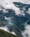
This photo is probably Penalba, barely visible in the center of the picture if you enlarge it.
Screenshot_20240116-094635~3.png
 
from Priaranza it heads off the road and goes up to Villavieja.
Oh yes. I remember that hill. Climbs up into the quarry wherefrom much of the stone for the castle was presumably cut. A spectacular view of the castle looming overhead.

I've by-passed Villavieja on subsequent trips. There is an excellent off-road (mostly) route from Priaranza to Borrenes cuts to the north of the N-536 and pops out at the road junction below Cornatel and provides a fairly level stroll into Borrenes
 
Not sure though if I would walk it if not well marked, but instead choose to see it as an extra tourist day as I am not a trailblazer if some sections are overgrown.
Hi Chrissy,

The trail from Ponferrada to Montes de Valdueza and then on to Peñalba was clear and open when I walked in 2014 and again in 2019. It’s about 24 km. I hope to be back in the spring, and will report back! At the beginning from Ponferrada it goes through a couple of nice little towns and into Montes de Valdueza (which has a monastery founded in 7C but whose buildings date from XVI I think). From the monastery to Peñalba is well off-road and rollows some of the canal system used by the Romans to exploit the gold in Las Médulas.

When I was last there, I walked from Ponferrada to Peñalba, hoping to sleep in Peñalba and continue on the next day to Las Médulas. I had some sort of GPS meltdown and didn’t want to risk going to Las Médulas without it. So I wound up hitching a ride back to Ponferrada with a couple who had toured the church at the same time I did. And just started the Invierno from the “normal” starting point. This year I have fingers crossed that I can make it from Peñalba directly to Las Médulas.

There is no public transportation to Peñalba, except, I think, an on-demand public transit vehicle for residents who call and ask for the service. But it is oh so worth a visit!
 
Down bag (90/10 duvet) of 700 fills with 180 g (6.34 ounces) of filling. Mummy-shaped structure, ideal when you are looking for lightness with great heating performance.

€149,-
€2,-/day will present your project to thousands of visitors each day. All interested in the Camino de Santiago.
Thanks everyone for your comments - and especially the fantastic pictures! @davejsy - did you bring a camera or did you manage these fantastic shots with your phone?

@peregrina2000 - that might be where my confusion comes in. In any case, the Valle de Silencio sounds like a fantastic de-tour. We aren't sure of our start day yet but if possible - time permitting - we might try to link Peñalba de Santiago to las Medulas. There's so far nothing obvious in Wikiloc or on my Garmin planner app. Garmin suggests a fair bit of road-walking so far but I'll have another deep-dive later.
 
New Original Camino Gear Designed Especially with The Modern Peregrino In Mind!
Thanks everyone for your comments - and especially the fantastic pictures! @davejsy - did you bring a camera or did you manage these fantastic shots with your phone?
Thank you @sun is shining - My phone, a Sony Xperia, no idea what model but it's about 18 months old. It can take some amazing photos, but it will miss a lot of things a camera would capture - but a decent camera on the Camino has it's own drawbacks.
 
Thank you @sun is shining - My phone, a Sony Xperia, no idea what model but it's about 18 months old. It can take some amazing photos, but it will miss a lot of things a camera would capture - but a decent camera on the Camino has it's own drawbacks.
That's really impressive! My partner likes photography and we'll probably bring a camera (I know but what the heart wants and the back can carry) because we are connecting from Spain straight over to Africa.
 
New Original Camino Gear Designed Especially with The Modern Peregrino In Mind!
That's really impressive! My partner likes photography and we'll probably bring a camera (I know but what the heart wants and the back can carry) because we are connecting from Spain straight over to Africa.
For sure, I'm a very keen photographer and my camera normally goes everywhere, and I did seriously consider trying to squeeze it in - I think a large part of that was due to FOMO.

But I don't regret not taking it now as I think it would have distracted me in a way that the ease and limitations of a phone didn't. I was thankful of the trade off I'd made. This isn't to say that depending on which Camino I do next I wouldn't consider my camera dilemma again.

I would have also had the security issue of an expensive camera on show, and also such dilemma's as what do you do with your camera when you have to leave your belongings (such as showers - which apparently it's frowned upon to take your camera into 🤣 ).

I think if you are a couple then that will solve some of the issues, and of course each circumstance and Camino is different.
 
No I kept to the pilgrim superhighway, but would love to try that route if I pass that way again.
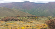
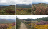
I'm thinking either you zoomed in with your camera for that closer image of the village or if I got that close on the trail at some point, I missed seeing it due to possible fog which rolled in and out. Walking that day was a glorious stand out memory for me on the Frances; a day of incredible beauty with the mountains, colorful landscape and we had the trail to ourselves.
Screenshot_20240117-063018~3.png
 
I'm thinking either you zoomed in with your camera for that closer image of the village or if I got that close on the trail at some point, I missed seeing it due to possible fog which rolled in and out. Walking that day was a glorious stand out memory for me on the Frances; a day of incredible beauty with the mountains, colorful landscape and we had the trail to ourselves.
View attachment 162255
It would have been zoomed in.

The colours in your photos are beautiful! What time of year was this?
 
3rd Edition. More content, training & pack guides avoid common mistakes, bed bugs etc
There's so far nothing obvious in Wikiloc or on my Garmin planner app.
If what you are talking about is from Peñalba to Las Médulas, there is an offroad trail. This wikiloc link shows only from the Monastery to Las Médulas, but I have walked twice from Peñalba to the monastery and there is a very good trail that links the two, about 7 km.

The trails in this area are sometimes referred to as "La Mirada Circular" so you may see that as well as Valle del Silencio.
 
From the monastery, the staff at the monastery has told me there is a marked 25 km trail directly to Médulas. I hope to walk that this spring.
I would not walk these trails without GPS
If what you are talking about is from Peñalba to Las Médulas, there is an offroad trail. This wikiloc link shows only from the Monastery to Las Médulas, but I have walked twice from Peñalba to the monastery and there is a very good trail that links the two, about 7 km.

The trails in this area are sometimes referred to as "La Mirada Circular" so you may see that as well as Valle del Silencio.
Didn't @Rebekah Scott have a mountainous adventure up there? It sounded mildly hair-raising. Maybe an overstatement - but certainly challenging.
 
The 2024 Camino guides will be coming out little by little. Here is a collection of the ones that are out so far.
Didn't @Rebekah Scott have a mountainous adventure up there? It sounded mildly hair-raising. Maybe an overstatement - but certainly challenging.
Here’s a recent thread in which Reb describes her experience. That thread also has some useful info for those considering this option. Rebekah does say several times on the forum it was the most difficult day for her on any camino, and I don’t doubt that. But sleeping in the monastery would make it a 25 km walk to Las Médulas, not the 32 she had to do from Peñalba. And the trails I have seen may be different than the one Rebekah walked, because the elevation profile does not look extreme. The staff in the monastery has told me there is a well-used trail from their place to Las Médulas, so maybe it’s also the case that the trail has become better groomed from more traffic. I don’t know, but hopefully @Rebekah Scott will see this and chime in!
 
Maybe I'm stating the obvious, but the simplest way to avoid Ponferrada is just don't turn left towards the bridge at Puente Boeza, but simply keep walking West and straight ahead towards Toral de Merayo, staying on the southern bank of the river.

The mountain trail variant out from El Acebo looks fairly exciting, but if mountain hikes are your thing, why not.

As to getting to Villavieja via that route, the only sensible option I can see is switch to a little northward (probably dirt) road at Campo de las Danzas, keep on it to Ferradillo -- then either chance the pathway from there down to Villavieja (it's a named path so it might be maintained) ; or keep on that (dirt) road to Paradela de Muces (which seems to have places to sleep), then from there to Villavieja.

All the possible options still look to me like a very significant and difficult detour, whereas avoiding Ponferrada is easy. And the worst section of the descent towards Molinaseca can be avoided by taking the tarmac from Riego de Ambrós until the point where the Camino crosses back over it to the right. There's very little traffic on that bit of tarmac.
 
All the possible options still look to me like a very significant and difficult detour,
I don’t know anything about the options you have suggested, but I would not classify any of the options I suggested as very difficult. People should look at the wikiloc tracks to see the elevation gain and descent — in the mountains, that’s as important (or more so) than distance. But here are two options that I think fall within the ability range of those who have been walking ”average” Francés stages (aka, something like Brierley stages, around 25-28 kms, I think).

1. Las Puentes de Malpaso from Riego de Ambrós to either Ponferrada or Molinaseca. This is a beautiful alternative to the rocky descent. This doesn’t avoid Ponferrada though, so is probably not what the OP is interested in. But I have in the past encouraged those on the Camino Francés to give it a try — there are lots of threads if you search for Puentes de Malpaso. I don’t think that avoiding a rocky descent and taking a beautiful wooded path over several ancient bridges would be heretical.

2. This option would avoid Ponferrada and take you to Las Médulas.

Day 1. El Acebo to Monastery of Valdueza, where there is an albergue. This option would go through Peñalba de Santiago. I’ve linked tracks above and they are good trails. That would be about 27 or 28 km.

Day. 2. The second day would be from Monastery of Valdueza to Médulas, about 24-25 km. That portion has been described by Rebekah as very difficult. The monastery had told me it was not. I also wrote to the author of this wikiloc track and he responded to me by saying that the trail is mostly on a wide dirt road and does not have any pronounced ascents. This may very well be a different trail than the one Rebekah followed, and it also may be because she walked from Peñalba, which would add 7 or 8 km. The trail I’m hoping to walk this spring has been recorded by lots of mountain bikes, which seems to corroborate the wide trail that the wikiloc guy described to me.

I understand that this may not be for everyone, but I think it is a beautiful option for those who are on the Francés, who are going to walk on the Invierno, and who don’t want to return to Ponferrada!
 
3rd Edition. More content, training & pack guides avoid common mistakes, bed bugs etc
I don’t know anything about the options you have suggested, but I would not classify any of the options I suggested as very difficult.
Well, "difficult" is obviously a relative quality, but El Acebo to Las Medulas is up to nearly 1,500 metres again, and the descent from Alto de la Cruz looks pretty steep to me. Then back up to ~1,450 metres at Campo de las Danzas, and overall it's fundamentally a crest trail. Now, that's obviously the right cup of tea for some people, and good for them, but in relative terms it's clearly more "difficult" than the valley route, whether you avoid Ponferrada or not.

In absolute terms, it's a longer distance on that variant and with higher elevation change numbers, as compared to the official route, which is what I mean by more difficult, i.e. more difficult than skipping Ponferrada by going directly Molinaseca > Puente Boeza > Toral de Merayo -- which doesn't mean it's particularly difficult compared to other mountain hikes.
I don’t think that avoiding a rocky descent and taking a beautiful wooded path over several ancient bridges would be heretical.
Nor would I !! And as to taking variant routes generally, here you're preaching to the converted ... ;)

Sure -- personally my own variants tend towards "easier" rather than "more scenic", but still, there's nothing heretical about stepping away from the yellow arrows on occasion.
I understand that this may not be for everyone, but I think it is a beautiful option for those who are on the Francés, who are going to walk on the Invierno, and who don’t want to return to Ponferrada!
Sure !! But you can skip Ponferrada anyway ...
 

Most read last week in this forum

Hi Folks can anyone advise about the ease. or lack of ease. of pack transport along the Invierno route? Many Thanks Michael.
We’re scoping out accommodation on the Invierno, and @C clearly noticed that Pensión As Viñas is on booking. There is an annotation “new to booking.” Many of us stayed there before the albergue...

❓How to ask a question

How to post a new question on the Camino Forum.

Similar threads

Forum Rules

Forum Rules

Camino Updates on YouTube

Camino Conversations

Most downloaded Resources

This site is run by Ivar at

in Santiago de Compostela.
This site participates in the Amazon Affiliate program, designed to provide a means for Ivar to earn fees by linking to Amazon
Official Camino Passport (Credential) | 2024 Camino Guides
Back
Top