

- Time of past OR future Camino
- Too many to count!
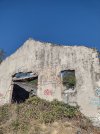
Hello, I am researching the Sanabrés and have discovered that since the AVE construction is complete, this section from Requejo to Padornelo has a new route available along the Requejo River. Our last time here we were forced to walk on the N-525 national highway this entire section and even through the tunnel at the top of the pass, the Alto de Padernelo. This tunnel route was not desirable, but not all that horrible in our experience. There still exists an alternate and much longer route from the N-525 that does avoid the pass and tunnel as well now.
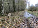
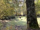
However, I am seeking information on the much shorter Requejo river route that avoids the N-525 altogether in this section. It appears that it has opened only within the last several months, if not weeks. Does anyone have any experience or information on this new river route?
All I could find after a Google search is from Gronze, and I have included a screen shot of its information, translated. As you can read, it is not recommended in the rain and is poorly signposted, but they describe it as the "official" path:


 . Currently in Campobecerros with coffee


