Search 62305 Camino Questions

LIVE from the Camino Ruta del Argar

Time of past OR future Camino
Camino Del Estrecho, Ruta Fray Leopoldo,
Vía Serrana, Camino Francés
We are currently walking the newly signposted Camino del Argar (named for the Bronze Age Argar civilization) from Almería to Lorca. While its nine stages are generally 20 to 30 km long, most of the stages can be broken into shorter lengths that are around 12-16 kilometers long. A link to the Wikiloc tracks is here:

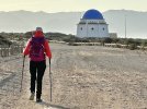
Ruta del Argar desde Almería : Etapa 1 de Almería a Cabo de Gata 25.52km o.w. wikiloc.59928106
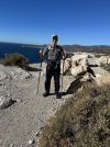
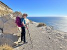
We had gorgeous sunshine all along this stage which we broke in half. Like most of the stages, there are no albergues, so it is a matter of finding casas rurales or hostales. Because this is a popular seaside destination for Spaniards in the summer, there are plenty of choices.
Where the stage can be broken: Retamar, km 16.4. rooms from 35 euros on AirBnb
It is also possible to start walking directly from the Almería airport because the trail runs directly south of the airport runways. Walk out the door, head toward the beach, and you are on the track!
End of stage accommodation: San Miguel de Cabo de Gata, km 25. Hostal Be Free, 45 euros double. Note that Hostal Las Dunas is not open in the off-season.
Food: grocery stores, restaurants, and bars in Retamar and San Miguel. Supermarket Marquez in San Miguel is open 7 days a week. 9-12 and 2-4 on weekdays; 9-2 on Sunday.
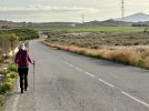
Trail conditions: Paseo Marítimo, paved, from Almería, and then sand and gravel. Flat, along the Mediterranean, in the Cabo de Gata Parque Natural.
Number of people met on the track: 20 on a weekday, hundreds on a weekend. No pilgrims, but lots of cyclists, dog-walkers, and families
OK for bikes? Yes, we were passed by more than a hundred mountain- bikers. There are a few areas of deep sand near San Miguel where everyone had to walk their bikes, but the rest of the track is easily cyclable. It’s part of eurovelo 8.
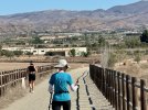
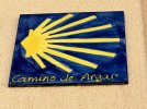
Signage: We didn’t spot any markers until we got to San Miguel, but you can’t go wrong because the track is either the paved Paseo Marítimo or is bounded by a wooden fence.
Shade: none
D979E63E-AEFE-4EFF-AE13-42B49A6168A3.jpeg 8B1A4C6A-7D36-4E93-89AB-CD8974251E11.jpeg
 
Last edited:
John Brierley 2023 Camino Guide
Get your today and start planning.
John Brierley 2023 Camino Guide
Get your today and start planning.
Time of past OR future Camino
Camino Del Estrecho, Ruta Fray Leopoldo,
Vía Serrana, Camino Francés
Ruta del Argar desde Almería : Etapa 2 desde (San Miguel) Cabo de Gata a San José 20.32 km o.w. wikiloc.59929092
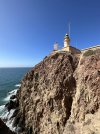
The wording in the title of this stage is a little confusing because the actual geographical feature of Cabo de Gata begins six kilometers after the village of San Miguel - which is also called Cabo de Gata!

The sunshine and good weather continued all along this stage which we again broke in half. Be sure to bring plenty of sunscreen and a good sun hat!

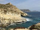
Of special interest: the bird blinds and salt flats shortly after San Miguel; the volcanic geology of the cape.
Where the stage can be broken: La Almadraba or La Fabriquilla, km 6. Many casas rurales on booking and Airbnb. We went a few km further and stayed in Casa de la Media Luna right by the lighthouse. It has a two night minimum, but we were glad to take a rest day in such perfect spot for contemplation and reflection.
End of stage accommodation: San José has an albergue with dorm beds. It’s on booking.com. We stayed at Casa Hans which turned out to be a really good find- quiet, central, and they let us check in early. 50 euros on Airbnb.
Food: small tienda in La Almadraba; nothing open in La Fabriquilla; grocery stores, restaurants, and bars in San José.
Trail conditions: Easy, flat walking on dirt trails beside the paved road to La Fabriquilla; paved road to the top of Cabo de Gata (closed to traffic after the lighthouse); wide dirt track to San Jose.
Number of people met on the track: No pilgrims, but 6 cyclists and 2 day-walkers going the other way.
OK for bikes? Yes. It’s part of eurovelo 8.
Signage: One at the top of Cabo de Gata and several in San José.
Shade: one tiny group of trees about 2 km before San José.

69595535-FEDE-4AE2-BF08-BE5600DEBEA5.jpeg D3290062-31E0-4EF6-B7AE-F555CEB1E63A.jpeg 535AD359-FA0A-41AA-ADBA-A715F6B26D8A.jpeg
 
Time of past OR future Camino
Camino Del Estrecho, Ruta Fray Leopoldo,
Vía Serrana, Camino Francés
Ruta del Argar desde Almería : Etapa 3 desde San José a las Negras 21.91km
wikiloc.59928311
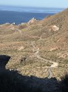
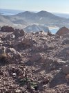
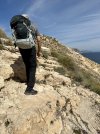
This stage offers the ultimate in coastal views, but those stunning cliffs also require some scrambling. The sure-footed will find this easy, but if you are like me and have balance issues, you will want poles for this stage.
Of special interest: the great explanatory signs between San Jose and Los Escullos that help you understand the volcanic geology.
Where the stage can be broken: Can stop in Los Escullos (9.2 km, hotel, campground, no store, restaurants closed in off-season), La Isleta (13km, many apartments, all with 2 night minimum or more), and Rodalquilar (16.5 km, mining center, casas rurales and restaurants)
End of stage accommodation: Las Negras has a hotel, a campground, and apartments, mostly with a 2 night minimum. Restaurants and bars.
Food: nothing open in Los Escullos - the kind people at Hotel Los Escullos shared the staff meal with us; grocery stores, restaurants, and bars in Las Negras.
Trail conditions: A short scramble at the top of the cliff out of San José, not hard or dangerous. Easy walking high above the water to Los Escullos on what would have been a road had the Parque Natural not come into being; 5 km on a busy paved road to the outskirts of Rodalquilar; wide concrete track to the Mediterranean; narrow rocky path up and down a cliff that will challenge the less-than-sure-footed for the last 2.5 km into Las Negras. No one else of the many day walkers we met had any problems, though, nor did Ned.
Number of people met on the track: No pilgrims, but 2 cyclists and many day-walkers near the beaches.
OK for bikes? Everything except the final 2.5 km into Las Negras is okay for mountain bikes. You’d have to carry the bike and gear on the last 2.5 km, though. We did not see any cyclists on it.
Signage: yellow arrows at most critical junctions, but the off-track signals from Wikiloc were essential for us
Shade: several groups of eucalyptus trees between Los Escullos and Rodalquilar. Otherwise none.
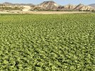
Photo note - none of the steepest parts - too busy trying to find a place to put my feet between the rocks to get the camera out.

7E4345FB-7DB0-4DEC-8D29-0C1CCB925B88.jpeg A8EAE7C3-8434-4E8B-9D08-CD9A58226A7D.jpeg C910E513-D144-4E5D-8D87-7B7B4D6AE4BB.jpeg DB3D1E50-F8FB-44E7-9FF9-CF7C0D0F9578.jpeg
 
Last edited:
Time of past OR future Camino
Camino Del Estrecho, Ruta Fray Leopoldo,
Vía Serrana, Camino Francés
Ruta del Argar desde Almería : Etapa 4 desde Las Negras a Carboneras 20.8 km wikiloc.59928348
More beautiful cliff walking above the sea. Las Negras to Agua Amarga requires some scrambling. Agua Amarga to Carboneras is mostly road walking. If you want to get off the road, here are some other choices:
3 ways to go from Agua Amarga to Carboneras:
  1. Official route via the road the entire way: 8.1km wikiloc.59928348
  2. West of the road via Canada de Marcos/Barranco del Hondo 8.5 km (adds 0.4km) wikiloc.8605250
  3. East of the road via Mesa Roldan tower and lighthouse 11.2 km (adds 3.1 km) wikiloc.8389139, wikiloc.90122604, and wikiloc.8605250.
Of special interest: the ruins of the Antiguo Cargadero de Mineral just after Agua Amarga. Turn right at the top of the climb out of Agua Amarga and take a short detour off the route to see these very interesting remains of the mining railroad that ran from the interior of Armeria to the Mediterranean in the late 1800s and early 1900s. Iron ore was shipped out and supplies destined for the mine were shipped in from here. Mine supplies were landed by ship and lifted up to the railway on the headland using a static engine that pulled small wagons up a very steep ramp using cables. You walk up the remains of this ramp as you leave Agua Amarga
Where the stage can be broken: Agua Amarga, km 12.1 has hotels, store (open on Sunday), restaurants, apartments. We stayed at Hotel Family, and the hearty included breakfast sets you up for a full day of walking!
End of stage accommodation: Carboneras has no albergue although one is planned. There are rooms as low as 26 euros on Airbnb. Also hotels, pensiones, and apartments, several with a one night minimum. We liked Apartamentos Playa Lancon, €60 on Airbnb.
Food and supplies: grocery stores, restaurants, and bars in Agua Amarga and Carboneras. Carboneras has a big Mercadona, a smaller Spar, a Chinese Bazaar, and well-stocked pharmacies.
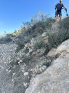
Trail conditions: A 200 meter scramble (at a 25% grade, compared to the 11% downhill slope of Alto Perdón) out of Cala de San Pedro was too eroded and steep for me to handle, although most people will find it okay. We very reluctantly resorted to a taxi around this, although Ned could have walked it fine were he not walking with me. In contrast, the climb from Agua Amarga up to Mesa Roldán is a short, steep (21%) scramble on loose rocks that hold their position surprisingly well. The rest of the way to Carboneras is on a busy paved road unless you use one of the alternatives listed above.
Number of people met on the track: No pilgrims, many day-walkers near the beaches.
OK for bikes? No. Too steep and rocky as far as Agua Amarga. We did not see any cyclists on it. Possible if using the road.
Signage: none that we saw.
Shade: none.
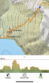
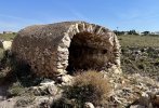
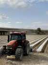
Photo notes: the topo map shows the climb and profile out of Las Negras: 200 meters in 0.8 km/656 feet in 0.4 miles. Judging by the number of tracks on Wikiloc, many people do this section quite successfully. Second photo: the cableway out of Agua Amarga. Third photo: terminus remains.

CDE9B9F6-1943-425F-8939-5DEEB7221C56.jpeg 67DE3B61-E151-468F-A25D-3C1594BB9517.jpeg C9DCE0CB-D89E-4622-A9DF-9A05E503D897.jpeg
 
Last edited:
Time of past OR future Camino
Yearly and Various 2014-2019
Via Monastica 2022
@islandwalker, I'm just catching up with you now, so pleased to find this thread. Better late than never!
Thank you for sharing, and in such a clear and informative way. Lots of scrambling, frim the sound of it.
the bird blinds and salt flats shortly after San Miguel; the volcanic geology of the cape.
Yes, please! 😊❤
 
How to Successfully Prepare for Your Camino
The focus is on reducing the risk of failure through being well prepared. 2nd ed.
Time of past OR future Camino
Camino Del Estrecho, Ruta Fray Leopoldo,
Vía Serrana, Camino Francés
Stage 5: Carboneras a Garrucha 26.29 km
wikiloc.62236443
This stage brings you to the northern border of the area protected by the Parque Natural Cabo de Gata. It is a pure joy to walk! Undeveloped beaches, birds, ibex, flowers, shade… It is the last stage along the Mediterranean. From Garrucha, the camino turns inland toward Lorca.
Of special interest:
Just after leaving Carboneras, you will see the famous beach where the Jordanian village of Aqaba was reconstructed for the film Lawrence of Arabia, a beach now made infamous by the Algorrobico Hotel, standing in its unfinished state for 20 years after being condemned by the courts for building within the Parque Natural Cabo de Gata boundaries.
Look up when you enter the delightful watercourse leading to Sopalmo, and you may see wild ibex leaping gracefully from crag to crag, silhouetted against the varied hues of the volcanic rocks.
Where the stage can be broken:
Km 8.4 Sopalmo - if you are waking short stages, turn off at km 8.4, follow the A-5107 for 0.5 km NE, and you will come to the delightful family-run Venta El Molino.€50 dbl; Delicious menú del día €15; fantastic experience. Highly recommended.!
Km 16.5 Puerto Marina/H. Best Indalo Bus runs from here to Mojacar Pueblo - once an hour, 15 minute ride, 1.20 euros, need correct change unique-almeria.com
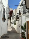
Km 18. Mojacar Playa and Mojacar pueblo in the hills above the beach strip. Even if you are not walking short stages, we found Mojácar pueblo to be a far more interesting place to stay than either Mojácar Playa or Garrucha. We stayed in a peaceful Airbnb, Casa Grande, close to everything on a quiet street with no traffic.
wikiloc.56208069 will lead you back to the camino.
End of stage accommodation: Hotels, rooms, and apartments in all price ranges in Garrucha.
Food: grocery stores, restaurants, and bars in Mojacar and Garrucha. Venta El Molino, 0.5 km off the track after Sopalmo serves a huge menú del día lunch for €15.
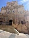
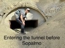
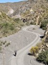
Trail conditions: This is an easier stage than the previous ones. The hillside tracks are gentler, following watercourses. Anyone with claustrophobia needs to plan ahead for the 0.4 km tunnel between Carboneras and Sopalmo. With my mild claustrophobia, I found it easier than expected. It’s about ten feet wide and ten feet high, with a generally smooth walking surface - just one pile of rocks shortly after entering. Although you can see light from the other end when you enter, you will need a flashlight! See photos: wikiloc.103005283 wikiloc.42029295
Number of people met on the track: No pilgrims, many day-walkers near the beaches, no one on the dirt trails.
OK for bikes? Okay on the dirt road parts, but the climb to and descent from Sopalmo is too steep and rocky for bikes. Around Garrucha, there are hundreds of club cyclists.
Signage: yellow arrows on rocks at some critical junctions, but the off-track signals from Wikiloc were essential for us
Shade: in the tunnel (!!!) and from bushes on the hillside to and from Sopalmo. Otherwise none.

IMG_0789.jpeg IMG_0795.jpeg IMG_1620.jpeg
 

How to ask a question

How to post a new question on the Camino Forum.

Similar threads

Forum Rules

Forum Rules

Camino Updates on YouTube

Camino Conversations

Most downloaded Resources

This site is run by Ivar at

in Santiago de Compostela.
This site participates in the Amazon Affiliate program, designed to provide a means for Ivar to earn fees by linking to Amazon
Official Camino Passport (Credential) | 2023 Camino Guides
Top