

- Time of past OR future Camino
- First: Camino Francés 2002; most recent: Norte/Primitivo 2019
Every time I return to the Camino del Norte, I’m caught trying to maintain a balancing act. On one hand, the top priority is to re-walk the official route and established alternatives, in service to updating the guidebook. On the other, there are so many other possible variants to explore! Time is finite, though, so I have to exercise some restraint. Fortunately, given that I re-walked the Norte from Gijón onward just two years ago, I had a little more freedom to experiment in that coastal stretch when I returned this summer. Following that exploration, I’m happy to share more detail on three variants that I briefly mentioned in my earlier summer posting:
1) An Unmarked Alternative between Tamón and Avilés (Stage 20)
This stage, between Gijón and Avilés, is in the running for the least appealing days on the Norte, and that judgement is driven largely by the beginning (through Gijón’s industrial outskirts) and the highway-bound ending. I haven’t been able to find a great alternative to the former (and I kind of enjoy the grittiness in its own way!), but it’s possible to escape the highway. (In each of the following maps, the official Norte is in red and the alternative is in green.)
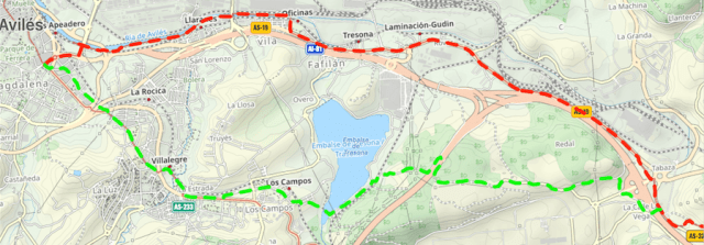
What is the variant: This 9.4km variant isn’t a formal “route,” but rather my own homebrew. It splits from the Norte in Tamón, almost immediately after it merges with the AS326. You’ll encounter a few rogue yellow arrows early on (ignore them; they must be vestiges of an older Norte), but after that you’re on your own most of the way (as such, you’re best off with gpx tracks for this route–available here). It’s paved much of the way, though you’ll get a nice respite in a wooded stretch when passing under the A8. The Embalse de Trasona is the major highlight, with a park offering a great spot for a break (fountain). The route then passes through Los Campos (bar) and Villalegre (all facilities) in the final approach to Avilés. Yellow arrows pop up in the latter, when the route intersects the variant from Oviedo.
Why you should do it: Dang, that walk along the highway is bleak. I make no claim to this variant being a great walk, but it’s peaceful, it gets you off pavement for a little more than a kilometer, and it’s actually 400m shorter than the “official” route.
Why you shouldn’t do it: If you’re not comfortable with gpx, there’s a greater risk of going astray if you’re just trying to operate off of a map. Similarly, if you’re not comfortable walking without other pilgrims around, it’s not a great option (though you will encounter locals walking around the reservoir).
2) The Senda Costa Norte between Salinas and El Castillo de San Martín (Stage 21)
As with the previous stage, this one misses the coast entirely. Given that the official route now bypasses Salinas entirely, you’ll rarely even catch a glimpse of the sea, save for when you cross the Nalón. However, this variant offers one of the longest beach-walking sections of the whole Norte:
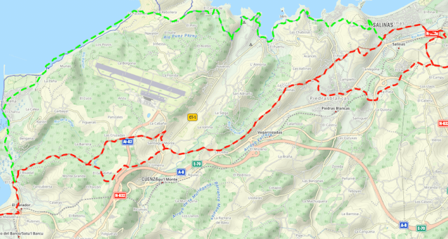
What is it: The Senda Costa Norte is a waymarked route that picks up in the hills just above Salinas. (While Salinas isn’t on the official Norte any longer, it’s still very easy to reach.) Much of it is offroad. It cuts through Arnao, which has a museum devoted to its extensive mining history, and then loops around Playa de Santa María del Mar (restaurant, camping, hotel). While the Senda Costa Norte continues to follow the coastal hills into La Arena, my suggestion is to descend to the beach for an easier, enjoyable walk.
Why you should do it: Nearly 70% of the official route follows pavement, and as noted it's inland with minimal views. And yet, services are quite limited along all that asphalt, with only Piedras Blancas offering a good resupply point. In contrast, this offers plenty of offroad time, good waymarking, great views, a little history, and a lot of beach time. It’s not any better on the service front, but at least it potentially offers multiple different food breaks.
Why you shouldn’t do it: The official route to El Castillo is 16.3km; this variant is 22.8km. That’s a big difference and may well be a deal-breaker for many pilgrims. Note as well that the descent to the Playón de Bayas is steep and has loose sand. Some may find it hazardous–that threat can be mitigated with an ungraceful butt-scoot downward, but that’s not for everyone
Note: In the summer in recent years, this company has run a passenger ferry across the Nalón between San Juan de la Arena and San Esteban de Pravia. Alas, this summer that service was suspended. If it returns, though, that would make this variant even more desirable, and would potentially shave off a few kms.
3) The Ruta de la Cangrexa between Hostal Canero and Luarca (Stage 23)
Continuing the theme, the route in this stage is inland throughout, never once touching the coast. The geography makes it harder to efficiently deviate from that in the first half of the walk, but a golden opportunity appears behind Hostal Canero:
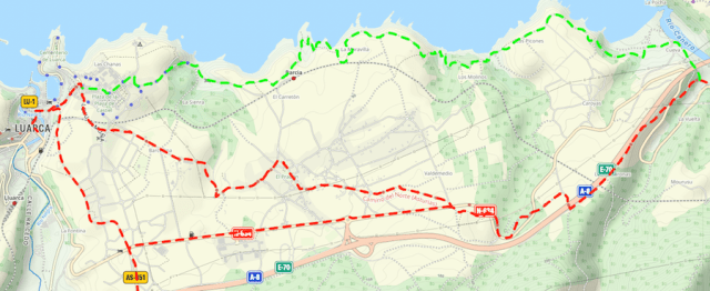
What is it: This waymarked (white and yellow blazes) route splits from the Norte behind Hostal Canero and follows the coast all the way to Luarca, only veering inland for the final approach. It passes a pair of isolated, small beaches: Playa de los Molinos and Playa de Portizuelo.
Why you should do it: This coastal approach is only 500m longer than the official route, and unlike the official it’s unpaved with fantastic views much of the time. The waymarking is great. You have so little time left on the coast–don’t miss this chance!
Why you shouldn’t do it: As is often the case, the coastal approach is more strenuous. This short walk has five different ascents (and four accompanying descents), and while they aren’t huge (50-100m), they add up. If you’re worn out, you may not appreciate the added exertion, regardless of the beauty,
I heartily recommend all three of these options. That section on the Norte between Gijón and Ribadeo can spend too much time inland for my taste, and these three variants offer a much-needed change of pace and scenery.
1) An Unmarked Alternative between Tamón and Avilés (Stage 20)
This stage, between Gijón and Avilés, is in the running for the least appealing days on the Norte, and that judgement is driven largely by the beginning (through Gijón’s industrial outskirts) and the highway-bound ending. I haven’t been able to find a great alternative to the former (and I kind of enjoy the grittiness in its own way!), but it’s possible to escape the highway. (In each of the following maps, the official Norte is in red and the alternative is in green.)
What is the variant: This 9.4km variant isn’t a formal “route,” but rather my own homebrew. It splits from the Norte in Tamón, almost immediately after it merges with the AS326. You’ll encounter a few rogue yellow arrows early on (ignore them; they must be vestiges of an older Norte), but after that you’re on your own most of the way (as such, you’re best off with gpx tracks for this route–available here). It’s paved much of the way, though you’ll get a nice respite in a wooded stretch when passing under the A8. The Embalse de Trasona is the major highlight, with a park offering a great spot for a break (fountain). The route then passes through Los Campos (bar) and Villalegre (all facilities) in the final approach to Avilés. Yellow arrows pop up in the latter, when the route intersects the variant from Oviedo.
Why you should do it: Dang, that walk along the highway is bleak. I make no claim to this variant being a great walk, but it’s peaceful, it gets you off pavement for a little more than a kilometer, and it’s actually 400m shorter than the “official” route.
Why you shouldn’t do it: If you’re not comfortable with gpx, there’s a greater risk of going astray if you’re just trying to operate off of a map. Similarly, if you’re not comfortable walking without other pilgrims around, it’s not a great option (though you will encounter locals walking around the reservoir).
2) The Senda Costa Norte between Salinas and El Castillo de San Martín (Stage 21)
As with the previous stage, this one misses the coast entirely. Given that the official route now bypasses Salinas entirely, you’ll rarely even catch a glimpse of the sea, save for when you cross the Nalón. However, this variant offers one of the longest beach-walking sections of the whole Norte:
What is it: The Senda Costa Norte is a waymarked route that picks up in the hills just above Salinas. (While Salinas isn’t on the official Norte any longer, it’s still very easy to reach.) Much of it is offroad. It cuts through Arnao, which has a museum devoted to its extensive mining history, and then loops around Playa de Santa María del Mar (restaurant, camping, hotel). While the Senda Costa Norte continues to follow the coastal hills into La Arena, my suggestion is to descend to the beach for an easier, enjoyable walk.
Why you should do it: Nearly 70% of the official route follows pavement, and as noted it's inland with minimal views. And yet, services are quite limited along all that asphalt, with only Piedras Blancas offering a good resupply point. In contrast, this offers plenty of offroad time, good waymarking, great views, a little history, and a lot of beach time. It’s not any better on the service front, but at least it potentially offers multiple different food breaks.
Why you shouldn’t do it: The official route to El Castillo is 16.3km; this variant is 22.8km. That’s a big difference and may well be a deal-breaker for many pilgrims. Note as well that the descent to the Playón de Bayas is steep and has loose sand. Some may find it hazardous–that threat can be mitigated with an ungraceful butt-scoot downward, but that’s not for everyone
Note: In the summer in recent years, this company has run a passenger ferry across the Nalón between San Juan de la Arena and San Esteban de Pravia. Alas, this summer that service was suspended. If it returns, though, that would make this variant even more desirable, and would potentially shave off a few kms.
3) The Ruta de la Cangrexa between Hostal Canero and Luarca (Stage 23)
Continuing the theme, the route in this stage is inland throughout, never once touching the coast. The geography makes it harder to efficiently deviate from that in the first half of the walk, but a golden opportunity appears behind Hostal Canero:
What is it: This waymarked (white and yellow blazes) route splits from the Norte behind Hostal Canero and follows the coast all the way to Luarca, only veering inland for the final approach. It passes a pair of isolated, small beaches: Playa de los Molinos and Playa de Portizuelo.
Why you should do it: This coastal approach is only 500m longer than the official route, and unlike the official it’s unpaved with fantastic views much of the time. The waymarking is great. You have so little time left on the coast–don’t miss this chance!
Why you shouldn’t do it: As is often the case, the coastal approach is more strenuous. This short walk has five different ascents (and four accompanying descents), and while they aren’t huge (50-100m), they add up. If you’re worn out, you may not appreciate the added exertion, regardless of the beauty,
I heartily recommend all three of these options. That section on the Norte between Gijón and Ribadeo can spend too much time inland for my taste, and these three variants offer a much-needed change of pace and scenery.


")


