• For 2024 Pilgrims: €50,- donation = 1 year with no ads on the forum + 90% off any 2024 Guide. More here.
    (Discount code sent to you by Private Message after your donation)
  • ⚠️ Emergency contact in Spain - Dial 112 and AlertCops app. More on this here.

Search 69,459 Camino Questions

Vila do Conde to Arcos route information

Time of past OR future Camino
2024
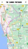
I am starting the CP in April (2024) and would like to walk to Vila do Conde then cut to Arcos on the Central route. But I can't find any information for this route - with walking map. Google Maps walking shows very dangerous road walking with little or no path off the asphalt. There must be a safer path.
 
The 9th edition the Lightfoot Guide will let you complete the journey your way.
OSMAnd+ shows a route that is largely on the EN309, EM 525 and EN 306, which might well be the route that Google maps also shows. I haven't walked that route to know whether your assessment that it is very dangerous is accurate, but Google Street View does show that there are substantial stretches with a walking verge to the roadway. There are some that don't too. I'm not sure that there is going to be a workable alternative. After Vila do Conde, the Central and Costal/Littoral are getting much further apart until around Caminha.
 
Join our full-service guided tour of the Basque Country and let us pamper you!
When I did it in 2018, I turned right immediately after crossing the bridge into Vila do Conde and started walking east along the north shore of the river. I followed the yellow arrows which led me to Arcos. I've since read there is another route along an aqueduct which some prefer, but I can't speak to that route.
 
Sao Pedro de Rates was the destination, but I believe you pass through Arcos to get there.
The Wise Pilgrim app has another route a little further north, for which @trecile has posted a screen shot. It doesn't appear on the maps in OSMAnd+, but appears to follow what might be a far more comfortable alignment to walk. It doesn't go through Arcos, but joins the central route just before Sao Pedro de Rates.
 
The one from Galicia (the round) and the one from Castilla & Leon. Individually numbered and made by the same people that make the ones you see on your walk.
New Original Camino Gear Designed Especially with The Modern Peregrino In Mind!
I walked from Vila de Conde to Sao Pedro and walked past the aquaduct. I had problems finding the route from there. Probably I missed the first arrow. Two local people directed me in two opposite directions. In the end you will get to Sao Pedro.
If you follow rhe arrows you will walk many times on dangerous narrow roads with little walking space. ( thats what I disliked most about the xamino Portugues) Be prepared!
 
We walked from Vila de Conde to Rates last April, following the Aqueduct route. Much nicer than the route that goes to Arcos. It's a bit tricky to find but starts up a hill and some steps on the right soon after the bridge. It does follow the Aqueduct for a long portion. The yellow arrows marking the route look like lichen so not always obvious. We followed the Wise Pilgrim App.
 
I am starting the CP in April (2024) and would like to walk to Vila do Conde then cut to Arcos on the Central route. But I can't find any information for this route - with walking map. Google Maps walking shows very dangerous road walking with little or no path off the asphalt. There must be a safer path.
I did that route last June with 10 others. The route from Vila do Conde to Arcos is all road with little footpath( about 10k) Myself and 3 others got a taxi to Arcos and walked to Barcelos which was about 22k. Those that walked the whole way would not recommend the road walk, about 32k in total.
 
Technical backpack for day trips with backpack cover and internal compartment for the hydration bladder. Ideal daypack for excursions where we need a medium capacity backpack. The back with Air Flow System creates large air channels that will keep our back as cool as possible.

€83,-
I am starting the CP in April (2024) and would like to walk to Vila do Conde then cut to Arcos on the Central route. But I can't find any information for this route - with walking map. Google Maps walking shows very dangerous road walking with little or no path off the asphalt. There must be a safer path.
Some people have difficulty walking down Portuguese roads because of the perceived lack of consideration to pedestrians by Portuguese drivers.
There is a much quoted adage on this forum to "Walk your own Camino!"
I interpret this to mean you do not have to slavishly walk every single step of the approved routes. You can chop and change your route and even include public transport options to get round dangerous or difficult sections.
There are public buses from Vila do Conde that will drop you in Arcos. If you wanted to continue further along the coastal path there are also public transport options to connect through to Barcelos where you rejoin the central route.
I became ill in Barcelos when I did this route. When I got to Ponte de Lima I realised I would not have the strength to make the tough ascent so I took the local bus to the top of the hill and continued from there at a slower rate. By the time I reached Valenca I had recovered and had a more enjoyable Camino
Thank you for that. It makes me more confident.
 
I am starting the CP in April (2024) and would like to walk to Vila do Conde then cut to Arcos on the Central route. But I can't find any information for this route - with walking map. Google Maps walking shows very dangerous road walking with little or no path off the asphalt. There must be a safer path.
I walked the Portuguese Camino in September 2023. We walked the coast from Porto to Fao and then took at taxi inland (22 euros) to Barcelos to walk the central route. If I had more time, I would have taken the eco via (bike path) from Pavoa de Varzim over to the central route. There is also a bus that runs frequently from Esposende to Barcelos.
 
A selection of Camino Jewellery
I'm considering taking the eco via path from Povoa de Varzim to Sao Paulo de Rates, as Nanners mentioned, instead of cutting over to the Central route from Vila do Conde. I'd love some perspective from someone who has taken that route before. Thanks!
 
I just "walked" it on Google Maps and it looks like a much straighter route. BUT - it is almost all on extremely narrow lanes most without footpath, and cobblestones the whole way. Still, worth considering.
 
3rd Edition. More content, training & pack guides avoid common mistakes, bed bugs etc
I will be in Porto April 18-19. Starting in Matosinhos on 20 April. Buen Camino.
We're tentatively leaving Porto a few days before you, Soul Desire. Hopefully we'll meet up somewhere along the way!

Per Anarilho on another thread about this subject, " the start of the paved ecovia / cycleway is within 100 metres or so of the [Povoa de Varzim] metro station. The distance from the Povoa metro right to the middle of Rates (the albergue) is 14km and following the ecovia couldn't be easier! You'd be in the open countryside after about 2 or 3km from the start. To me it's the obvious choice and it's very pleasant, quiet countryside."
 
Very light, comfortable and compressible poncho. Specially designed for protection against water for any activity.

Our Atmospheric H30 poncho offers lightness and waterproofness. Easily compressible and made with our Waterproof fabric, its heat-sealed interior seams guarantee its waterproofness. Includes carrying bag.

€60,-
I just "walked" it on Google Maps and it looks like a much straighter route. BUT - it is almost all on extremely narrow lanes most without footpath, and cobblestones the whole way. Still, worth considering.
Everything is narrow on Google maps/earth. I would not categorize any part as extremely narrow.
 
I walked the Portuguese Camino in September 2023. We walked the coast from Porto to Fao and then took at taxi inland (22 euros) to Barcelos to walk the central route. If I had more time, I would have taken the eco via (bike path) from Pavoa de Varzim over to the central route. There is also a bus that runs frequently from Esposende to Barcelos.
Thanks Nanners. I explored your advice and have opted to walk to Esposende along the coast, and take the bus to Barcelos. I think I will enjoy the coastal route.
 
Great decision! My husband and I walked from Vila do Conde to Arcos in September, and it wasn't nice. We took a taxi part way because we felt it was dangerous to walk (no shoulder, steep concrete walls, lots of agricultural trucks). The best part of the Central after Arcos starts in Barcelos, in my opinion. And it's really nice walking to Esposende.
 
New Original Camino Gear Designed Especially with The Modern Peregrino In Mind!
For those taking the bus from Esposende, make sure you check the bus schedules. IIRC, the bus runs fairly frequently M-F, less so on Saturdays and even less on Sunday. Rome 2 Rio is helpful.
 

Most read last week in this forum

My final question since I have asked sooo many. Grabbing a light lunch that I can get on the go, hoping to grab it, and find a square or a bench to enjoy it, then get back to walking. Not really...
Hello everyone! My wife and I are doing our first Camino in Sept and I was very curious about the stretch from Tui to Pontevedra. We have been to Spain multiple times and love the small towns...
We arrived in Lisbon yesterday, 48 hrs (by choice via Singapore, Milan and Madrid) after leaving home from regional South Australia. Train to Porto tomorrow hitting the pilgram path on Saturday to...
I’ll be finishing the Caminho Português next month. Last year I wore Hoka Challenger 6 ATR shoes. I did have some blisters and foot pain, but a lot could have been due to the 30+km days from...
Hello, I lost my GoPro with all my pictures on the Camino between Pedra Furada and Aborim last week. Is there a lost and found in SDC? Any other ideas? Thanks and Buen Camino.

❓How to ask a question

How to post a new question on the Camino Forum.

Forum Rules

Forum Rules

Camino Updates on YouTube

Camino Conversations

Most downloaded Resources

This site is run by Ivar at

in Santiago de Compostela.
This site participates in the Amazon Affiliate program, designed to provide a means for Ivar to earn fees by linking to Amazon
Official Camino Passport (Credential) | 2024 Camino Guides
Back
Top