Hi Eva! Thank you very much for your review! The Saiatz alternative is
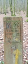
Camino de Santiago and therefore is indicated with yellow arrows. I'm afraid I can't answer your question, I can't say if for you it's too much or something feasible to go 35 km up and down tracks on farm roads, and cross the Hernio mountain range.
What I can tell you is that for someone like me it would not be very possible, not enough time, because I like to stop to enjoy the views, to stop to enjoy the song of a robin, the flight of a vulture or an eagle passing close by, or to take a detour a few meters to stop and observe the remains of Neolithic tombs.
Besides, I don't think you would have time to stop at Zelatun and have some refreshments at the mountain bar.
If you were leaving from Hernani I think I would encourage you to do both stages. But leaving from Astigarraga, it might be better for you to reach Tolosa through the valley. And the next day take the bus to Bidania and do the Bidania -Beasania
and do the route Bidania -Beasain
I share the links of Wikiloc (I do not know if you know it is an app that requires an annual payment but in my opinion if you like walking in the mountains is very worthwhile) of the Basque government on this alternative Saiatz:
Stage 2b:
Wikiloc | 02b Donejakue bidea (Barnealdea) /
Camino de Santiago (Interior). Hernani - Bidania Ibilbidea Hernani, País Vasco (España) [eu] Aipatu dugun beste aukerak –Saiatz ibilbideak– Aizkorri mendilerroraino garamatza, Gipuzkoa eta Araba arteko mugara, alegia, Oria haraneko mendebaldeko...

eu.wikiloc.com
Stage 3b:
Wikiloc | 03b Donejakue bidea (Barnealdea) /
Camino de Santiago (Interior). Bidania-Zegama Ibilbidea Bidania, País Vasco (España) [eu] Bide zati honetan, indarrik gehienak Murumendi, tarte gipuzkoarreko oztopo geografiko handienetakoa dena, igotzen erabiliko ditugu. Zidorra lurralde...
eu.wikiloc.com
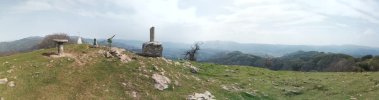
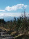
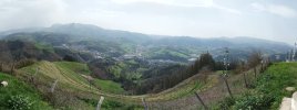
These are 30 and 33 consecutive km of up and downs to Zegama but through farmhouses and typical villages of Gipuzkoa. Pure delight, besides crossing the Hernio mountain range in the 2b and the Murumendi massif in the 3b.
The proposal that I proposed was in the 3b: Start from Bidania the road to Santiago following the yellow arrows, climb to the top of the Murumendi which is 50 meters higher than the trail and , from the Murumendi mountain down to Beasain. To do this, leave behind the road to Santiago 500 meters ahead at the junction that turns to the sale of Mandubia, and pull straight towards Beasain. So explained it seems complicated but with the help of Wikiloc it is super simple. I absolutely recommend climbing the peaks of Murumendi and Usurbe have views of the valleys, the mountains, that remove the hiccups.
It would be to follow this path (but instead of leaving from Albiztur, leave from Bidania. Once in the farmhouse Venta de Santutxu, follow the whole route:
Wikiloc | Beasain-Usurbe-Murumendi-Barrio de Santa Marina-Albiztur Ibilbidea Beasain, País Vasco (España) Vuelta al País Vasco desde Ermua. Etapa 62: Comienzo en la estación del cercanías de la localidad guipuzcoana de Beasain. Paso al lado del ayuntamiento, y luego me dirijo cuesta arriba...
eu.wikiloc.com
¡Buen Camino!


 My friend and I are starting the Camino Vasco on the 28th of April and we absolutely want to do the first stage of this Saiatz variant to Bidanea and then by bus to Tolosa. If the weather permits, of course. We are just a little bit uneasy about it, because, we are planning to stay the night of stage 1 in Santiagomendi, which adds some 6km to it, alltogether ca. 35km. I hope it is marked somehow. What do you think, Mendizale, too much for 2 pelegrinas on the second day of walking?


 Absolutely great! Respect! Yes, it's about stopping for good views, about listening to the birds, about enjoying the camino.. So we will follow your advice and prolong the 1st stage to Hernani. And then we'll see. If the weather is fine we are going to do the variant according to your advice. Yes, I know Wikiloc. It's not widely used in our country, but we already used it in Spain, so we'll do it again.
 By the way Zelatun is only open at the end of the week, unfortunately it will be closed for us. Thank you again, wish you all the best..