- Time of past OR future Camino
- See signature.
note from the mod: This is Damien’s report on part 1 of his walk, Almería to Granada. With his approval we have merged two separate threads to make one continuous report.
First of all I would like to thank the friends on this forum who pointed me to the Mozarabe for my January Camino. I have been having a blast.
I would also like to thank the association dedicated to helping peregrinos between Almería and Granada. Truly a unique experience. https://www.facebook.com/CaminoMozarabeDesantiagodealmeriagranada?mibextid=LQQJ4d
1) The Association: at first I was hesitant to contact them. I mean, I've managed Caminos on my own 20+ times... but two days before I left I got in contact with them. I whats app'd the association and then was put in contact with Nely who was my main contact. On my rest day in Almería she invited me to her home / Albergue, and she provided a credential and took me through the entire journey as recorded in the group's guide. It was a heartwarming experience. Later, she was literally like a "concierge" guiding me along and answering my questions. Let me stress this: YOU HAVE TO CONTACT THE GROUP IF YOU ARE GOING TO WALK THIS ROUTE. Only through the group are you granted "codes" to get into the Albergues. There are no on-site hospitalero/a.
2) The Albergues: Now I am usually a "hoteligrino" but that was not an option on this journey. The municipal albergues or those associated with the group were some of the best I've ever stayed in. In most of the stops there were no hotels. The albergues had small capacities, divided into separate rooms. I had a "private room" on more than half the nights, and at most shared a room with 1 other person. Most had well stocked kitchens, and there was always heat. Very casual and comfortable.
3) The weather: OMG, this is all I could ask for in January on the Camino. It rained the first day, but after that it was sunny, dry, and mild the entire time. Daytime temps were in the 60's F (15-20 C). In the mornings it was usually about 45F (7C) but warmed up quickly with the sun. I wore shorts often.
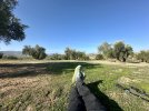
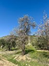
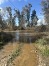
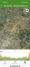
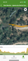
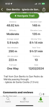
4) The trail: it reminded me of the high desert in California. Dry. Bushes at the lower altitudes but some pines when you climbed a bit. I would not characterize this camino as neither easy nor hard. No crazy vertical days or super long days, but varied enough terrain to be interesting. Completely manageable for peregrinos of all fitness levels IMO.
5) The company: I've met a total of 6 other pilgrims on the route. It is not a "social / family building" camino... there is one Italian couple who has shared my exact itinerary (doubling up on some short stages). The rest of the people I've met are either a day or two behind. I expected the route to be sparsely populated and I am enjoying the change of pace.
Conclusion: Based on my experience so far, I would highly recommend the Mozarabe from Almería for pilgrims looking for a journey in January and are willing / want to "step outside the box" a bit.
I will post another update when I get to Merida.
First of all I would like to thank the friends on this forum who pointed me to the Mozarabe for my January Camino. I have been having a blast.
I would also like to thank the association dedicated to helping peregrinos between Almería and Granada. Truly a unique experience. https://www.facebook.com/CaminoMozarabeDesantiagodealmeriagranada?mibextid=LQQJ4d
1) The Association: at first I was hesitant to contact them. I mean, I've managed Caminos on my own 20+ times... but two days before I left I got in contact with them. I whats app'd the association and then was put in contact with Nely who was my main contact. On my rest day in Almería she invited me to her home / Albergue, and she provided a credential and took me through the entire journey as recorded in the group's guide. It was a heartwarming experience. Later, she was literally like a "concierge" guiding me along and answering my questions. Let me stress this: YOU HAVE TO CONTACT THE GROUP IF YOU ARE GOING TO WALK THIS ROUTE. Only through the group are you granted "codes" to get into the Albergues. There are no on-site hospitalero/a.
2) The Albergues: Now I am usually a "hoteligrino" but that was not an option on this journey. The municipal albergues or those associated with the group were some of the best I've ever stayed in. In most of the stops there were no hotels. The albergues had small capacities, divided into separate rooms. I had a "private room" on more than half the nights, and at most shared a room with 1 other person. Most had well stocked kitchens, and there was always heat. Very casual and comfortable.
3) The weather: OMG, this is all I could ask for in January on the Camino. It rained the first day, but after that it was sunny, dry, and mild the entire time. Daytime temps were in the 60's F (15-20 C). In the mornings it was usually about 45F (7C) but warmed up quickly with the sun. I wore shorts often.
4) The trail: it reminded me of the high desert in California. Dry. Bushes at the lower altitudes but some pines when you climbed a bit. I would not characterize this camino as neither easy nor hard. No crazy vertical days or super long days, but varied enough terrain to be interesting. Completely manageable for peregrinos of all fitness levels IMO.
5) The company: I've met a total of 6 other pilgrims on the route. It is not a "social / family building" camino... there is one Italian couple who has shared my exact itinerary (doubling up on some short stages). The rest of the people I've met are either a day or two behind. I expected the route to be sparsely populated and I am enjoying the change of pace.
Conclusion: Based on my experience so far, I would highly recommend the Mozarabe from Almería for pilgrims looking for a journey in January and are willing / want to "step outside the box" a bit.
I will post another update when I get to Merida.
Last edited by a moderator:


 Hokas all the way! My first choice !
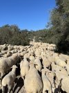


")