Donnakaten
New Member
- Time of past OR future Camino
- None yet
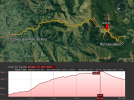
Where can I find online, the elevation gains and losses for each stage of the Via Podiensis? It would be of great help in determing the length of each days walk.
| For 2024 Pilgrims: €50,- donation = 1 year with no ads on the forum + 90% off any 2024 Guide. More here. (Discount code sent to you by Private Message after your donation) |
|---|