Last year I used it in the same way.
Download the file for that day and select the app with which to open it.
Very easy and a great resource.
I think since developing their own mapping app, they took off the file download.
But you can just download the Gronze mapping app, and use them in that way.
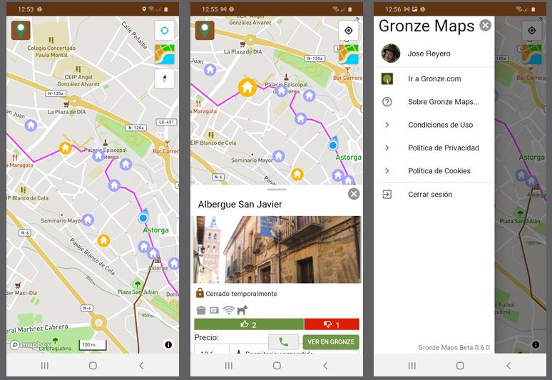
On opening the app you will see the routes.
Personally I preferred opening the downloadable file in Maps.me as it had great functionality and additional information.
I started off using the files in Wikiloc and it drove me nuts to be honest. It was somewhat 'bloated' with functions I didn't need making it cumbersome to use. For me at least. Frequently it would also sound an alarm saying I was going in the opposite (wrong) direction when I clearly wasn't. I gave up with it.
Maps.me was much more user friendly.
")
I haven't used the Gronze maps app yet though, but it looks more than adequate.
And I tend to 'trust' the Gronze tracks. In 1,200 kms last year I never had a problem with them. Up to date and accurate.
The issue I have with Wikilocs and others, is where to source the map files (tracks)
I found myself combing through hundreds of tracks by various people, not knowing how accurate or up to date they were. Was I following an idiot that got lost! Having to read reviews etc etc. To find publishers of 'good' tracks. And with the worry that I was following some persons track that might have included an unintentional detour or whatever. Gee. Why bother?
Whereas Gronze provides one track. the track to take.
And it seemed to be well updated.
Why over complicate things?
But. Not sure if the Gronze maps app works with iphone yet...........