Search 69,459 Camino Questions

Some difficulty now (Feb 2024) on the camino de invierno

JLWV

Jean-Luc
Time of past OR future Camino
Levante (2014-2016); Levante to Toledo (2017-2018), to be continued; Fisterra & Muxia (2018);
Very light, comfortable and compressible poncho. Specially designed for protection against water for any activity.

Our Atmospheric H30 poncho offers lightness and waterproofness. Easily compressible and made with our Waterproof fabric, its heat-sealed interior seams guarantee its waterproofness. Includes carrying bag.

€60,-
I was looking to walk the Invierno late this month. I’d better research this alternative if I still want to walk it
 
Get a spanish phone number with Airalo. eSim, so no physical SIM card. Easy to use app to add more funds if needed.
The alternative path from Borrenes to Orellan goes down into and crosses the Arroyo de Isorga further south. It is not a detour I would repeat by myself in potentially muddy/wet conditions, when the stream might be higher. Instead, about 350m past La Chana you could stay on the road instead of going left on the path shown with the red arrow in this photo. That would mean 3 km on a curvy paved road with no shoulder. However, the alternative from Borrenes to highway N-536 into Carucedo looks worse, as it is also without shoulder, but likely a lot more traffic.

I am thinking of doing this in May, and hope they will have fixed the path by then. If not, maybe I'll do the Borrenes to Orellan shortcut anyway, but will advise someone to confirm that I have emerged from the arroyo that afternoon!
 

Attachments

  • 1707589617697.png
    1707589617697.png
    1.4 MB · Views: 105
Thanks, @C clearly. Can I ask you to take a look at the wikiloc tracks linked below and see if I understand what you have suggested. It looks like after La Chana, you could get off the track and get on the LE-6621 and take that into the village of Orellán and then back onto the track to the Mirador?


If that’s correct, my calculation is that it would only add about 500 m to the total. So that’s a good alternative to the alternative in case of dicey weather, because it misses the ascent to Orellán on the path that some have described as dicey.
 
the wikiloc tracks linked below
That is the track that I have.
you could get off the track and get on the LE-6621
If you mean LE-6221, then yes, you stay on the LE-6221. There is probably not much traffic on that section, but it is something to take care about, especially if the visibility is poor.
 
3rd Edition. More content, training & pack guides avoid common mistakes, bed bugs etc
The alternative path from Borrenes to Orellan goes down into and crosses the Arroyo de Isorga further south. It is not a detour I would repeat by myself in potentially muddy/wet conditions, when the stream might be higher. Instead, about 350m past La Chana you could stay on the road instead of going left on the path shown with the red arrow in this photo. That would mean 3 km on a curvy paved road with no shoulder. However, the alternative from Borrenes to highway N-536 into Carucedo looks worse, as it is also without shoulder, but likely a lot more traffic.

I am thinking of doing this in May, and hope they will have fixed the path by then. If not, maybe I'll do the Borrenes to Orellan shortcut anyway, but will advise someone to confirm that I have emerged from the arroyo that afternoon!
Thank you
 
going left on the path shown with the red arrow in this photo
C, I absolutely loved this detour! Have never opted for the road. It will be interesting to see how it goes for you. The Buen Camino GPS app shows it beautifully. I pre walked it on Google too. Laurie, it is the same as the track in Wikiloc to pueblo de Orellan.
 
After Villavieja and the gorgeous bit of path that goes through huge trees to the castle, the Camino goes down and joins the road to go to Borrenes. You can avoid a lot of that roadwalking by turning left on a path that goes across fields through Paradela does Muces and then through Chana. Then you walk out of Chana on the road for a ways before joining the trail that goes up and across the river into Orellan. You can see these paths on Mapy. Last May the path into Orellan was very overgrown in the top part. Not at all pleasant! But it was great to stay there. O Paillero do Forno is a great little hotel with a very good restaurant. In the morning I just followed the road up to the mirador. I think there is also a path but the road was empty. And it was great to be at the mirador early and alone! But if you go early the galleries won’t be open.
 
The focus is on reducing the risk of failure through being well prepared. 2nd ed.
You can avoid a lot of that roadwalking by turning left on a path that goes across fields through Paradela does Muces and then through Chana.
This looks very interesting, and I've added it to my Organicmaps collection. Is it a path that seems perennial - i.e. not just this year when the fields are plowed a certain way? Also how crude is the path from Paradela de Muces across the Arroyo Los Alamos to La Chana? How does it compare with the following part...?

Last May the path into Orellan was very overgrown in the top part.
I felt rather uncertain about the whole path down into the arroyo as well as back up into Orellan. (It was probably the uncertainly that bothered me more than any physical obstacles.)
 
So just to make sure I’m following along, what we are now discussing is a way to skip going into Borrenes for those who want to take the alternative route straight up to the Mirador de Orellán? Will someone correct this if I’ve messed up? (I can delete or edit my post to avoid confusion).

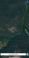
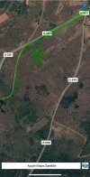
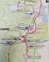
Leaving the castle, the road takes you down to Borrenes. Shortly after the castle, the “official camino” goes down to the right, while the road to Paradela de Muces goes off to the left. This looks like a minor road all the way into Paradela.

IMG_1800.png

From Paradela de Muces, go through La Chana. (there is a 3 km minor road in addition to the paths shown on the tracks, which might be better depending on the weather).

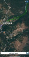
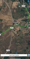
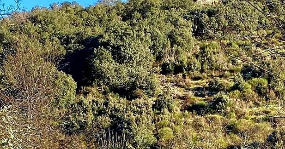
From La Chana, either take the road to Orellán or the path that crosses the arroyo.

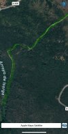
Looking for wikiloc tracks, I’ve found this one from Paradela de Muces to Orellán via La Chana. Although the title of the tracks is Villavieja-Paradela-Orellán, the author did not record from Villavieja to Paradela, but does have a lot of detailed verbal description. And the descriptioin also says that from Paradela to La Chana it can be complicated.


This track from 2021 doesn’t have any written description but it does show tracks from Villavieja to Paradela to Orellán


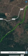
So, based on all of that, I think the best way to get from the castle to La Chana might be stringing together those minor roads. And then from La Chana, again it’s up to you to decide whether to cross the arroyo and ascend to Orellán through the scrub or forest, or whether to stay on minor roads for a few more kms.

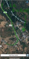
In any case, since the official route up from Borrenes seems to be messed up, that’s another reason to take the alternative up to Médulas, and this alternative to the alternative shortens things a few more kms.

This makes me nostalgic for our many years of putting together the annual forum guide to the Invierno!
 
A selection of Camino Jewellery
I’ve found this one from Paradela de Muces to Orellán via La Chana.
Yes, again that first track is the one I'm looking at, although I haven't read the description or studied the photos.

I agree with your assessment, but don't understand what the first images you posted are meant to illustrate.
 
This looks very interesting, and I've added it to my Organicmaps collection. Is it a path that seems perennial - i.e. not just this year when the fields are plowed a certain way? Also how crude is the path from Paradela de Muces across the Arroyo Los Alamos to La Chana? How does it compare with the following part...?


I felt rather uncertain about the whole path down into the arroyo as well as back up into Orellan. (It was probably the uncertainly that bothered me more than any physical obstacles.)

The path that goes left from the castle is through grassy fields where there were some cows. I would think it would be more or less the same from year to year -- it's a grazing field rather than a growing field. It is very open so you would be able to tell in advance whether it seemed like a good idea. The path that goes down from Paradela along the creek to Chana was okay -- a bit over grown and clearly not used a lot, but it was fine - there were some long grasses down by the creek. And walking through Chana was interesting (super tiny, no one about). Paradela was a bit bigger than Chana - but still really small. (I did get some ticks on my jacket sitting down in the grass just after Paradela - there was a good view though!)

I was a bit nervous to do the part between Paradela and Chana - but I did find a couple of wikiloc tracks (while I was standing on the side of the road by the castle trying to make up my mind!) -- which I cannot find now! So they were reassuring.

I am not 100% certain but I think the turnoff for the path that goes off the road up to Orellan was well marked. I had also read about it from you, I think, C! It definitely shows up on Mapy. But, honestly, the last part before Orellan was, for me, the least pleasant part of the whole Invierno! Super steep, too hot for me in the late afternoon, overgrown with vegetation. I was so tired I ended up hanging out for about 15 minutes on a bench in the village -- even though it was only about 5 minutes further to the hotel!
 
Join our full-service guided tour of the Basque Country and let us pamper you!
The path that goes left from the castle is through grassy fields where there were some cows. I
So, it looks like ML’s turn-off was before the road that I’m showing in the google maps streetview. ML, the castle is in the upper right where the red dot is. Do you remember if the turnoff was right there at the castle entrance or a little further down the road?

The turn-off I found to Paradela is at the junction where the blue arrow is, but that’s a road option not a field option. So looking back at the google maps screen shot, I would guess that your path leaves the road before my road turn-off, but looking at the map it doesn’t look like your way would be much shorter. I’m going to look on google maps to see if I can see the turn-off you took right outside the castle!
 
I was so tired I ended up hanging out for about 15 minutes on a bench in the village -- even though it was only about 5 minutes further to the hotel!
Same here! Here is what I wrote about it: "Finally I emerged from the hillside to a road in Orellán. I proceeded the last few hundred meters very slowly so as not to alarm anyone with my flushed and sweaty face."

Overall, I didn't find the stage unpleasant (any more than many steep/tiring stage). It was the uncertainty of whether this path would get me where it was supposed to go, that made me uncomfortable.
 
This track from 2021 doesn’t have any written description but it does show tracks from Villavieja to Paradela to Orellán


I think the second wikiloc track that Laurie has posted is the one I followed. Leave the albergue, go through the big trees, turn left right near the castle to follow a track across a grazing field that goes into Paradela. Leave out the other side of the village and follow a path down into the creek bed, along the creek bed into Chana. The paths are obviously not super well used but they are very visible. And you can follow along with wikiloc or mapy. If it were really wet I might just follow the camino down to the road to Borennes. And if it were very hot - I might consider staying on the small road that goes from Chana to Orellan. I think it is longer but it might be a bit easier.

Here is another wikiloc track that also has some text.
 
A selection of Camino Jewellery
It is interesting that Brierley's guide shows the alternative through La Chana but goes back to Borrenes instead of straight across to Orellán.
 

Attachments

  • 20240211_124047.jpg
    20240211_124047.jpg
    1.9 MB · Views: 70
I think the second wikiloc track that Laurie has posted is the one I followed.
And for those few die-hards who are continuing to follow this discussion, :p 
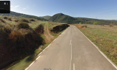
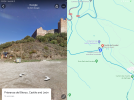
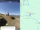
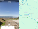
if ML followed the second wikiloc track that I posted, she took the road that is shown here right outside the castle entrance. I have one street view shot to the right (showing the castle) and one to the left (showing the path), and one straight ahead showing the official camino continuing on the paved road. Continuing straight on that road in turn then leads to the street turn-off I posted in # 11 above.

So that means there are two ways to get from the castle to Paradela, ML’s path showin in wikiloc tracks, and the road shown in #11.
 

Attachments

  • IMG_1803.png
    IMG_1803.png
    3.4 MB · Views: 56
  • IMG_1805.png
    IMG_1805.png
    3 MB · Views: 40
  • IMG_1807.png
    IMG_1807.png
    2.2 MB · Views: 35
It is interesting that Brierley's guide shows the alternative through La Chana but goes back to Borrenes instead of straight across to Orellán.
And just to be sure, do you agree that he does not show ML’s (and wikiloc’s) path to Paradela and La Chana, but rather the street version?

How odd that he would go back to Borrenes from La Chana, I can see no purpose to that at all. If you’re going to go to Borrenes just stay on the camino down from the castle.
 
Join our full-service guided tour of the Basque Country and let us pamper you!
So, it looks like ML’s turn-off was before the road that I’m showing in the google maps streetview. ML, the castle is in the upper right where the red dot is. Do you remember if the turnoff was right there at the castle entrance or a little further down the road?
It was definitely not a road -- just a narrow track across a grassy field. Right across from the castle itself....Here is what it looks like on Mapy, with my little red arrows added -- Mapy shows it near the castle parking:

785D02AA-559F-4378-946A-AD60B854079F.jpeg

And here is the zoomed out view of that map with the castle over at the right side (by the 824 elevation mark):

37111B7F-E49E-49DC-A9F3-5AB47CD87E8D.jpeg


And this photo is maybe looking back across that field to the castle, and you can see the narrow white path:

B4F3C3AA-A3EB-4027-9C41-D402305890B7_1_105_c.jpeg

Path going into Chana (after the creekiest parts):
B56A2F30-CDE0-497A-B6B4-F6BF32A38756_1_105_c.jpeg

Road going out of Chana, with the turn off somewhere ahead on the left:

144F3534-55D3-4A94-B463-9175BBF02415_1_105_c.jpeg
 
The 9th edition the Lightfoot Guide will let you complete the journey your way.
Damn! You guys are certifiable! 🤪😜😂
  1. From Borrenes walk on Calle de Arriba (away from the small center square out of town)
  2. Turn left at bifurcation onto LE-6203 towards La Chana (there are multiple small dirt road tracks that will also get you there if you look at the map)
  3. Exit La Chana on LE-6203 and take the bifurcation to LE-6201 which is straight ahead
  4. Find dirt road on your left going up a small hill into the dirt path…
  5. See pictures starting from Borrenes to Orellan
 

Attachments

  • IMG_6789.jpeg
    IMG_6789.jpeg
    1,023.9 KB · Views: 26
  • IMG_6797.jpeg
    IMG_6797.jpeg
    853 KB · Views: 29
  • IMG_6796.jpeg
    IMG_6796.jpeg
    810.3 KB · Views: 18
  • IMG_6795.jpeg
    IMG_6795.jpeg
    984.9 KB · Views: 16
  • IMG_6794.jpeg
    IMG_6794.jpeg
    911.6 KB · Views: 15
  • IMG_6793.jpeg
    IMG_6793.jpeg
    855.7 KB · Views: 12
  • IMG_6792.jpeg
    IMG_6792.jpeg
    847.5 KB · Views: 13
  • IMG_6791.jpeg
    IMG_6791.jpeg
    989.5 KB · Views: 16
  • IMG_6790.jpeg
    IMG_6790.jpeg
    884.2 KB · Views: 25
Now that I have finally figured this out and gotten things straight in my mind, I remembered that this year I am hoping to walk from Peñalba de Santiago to Médulas, which doesn’t go anywhere near Villavieja, the castle or Borrenes! But hopefully it will be of help to others.
OMG Laurie, LMAO. Yes we are all 😜🤪
 
From Borrenes walk on Calle de Arriba
Oh, dear @El Cascayal, the point of all of these posts was to make clear that there is a way to get to the mirador de Orellán and at the same time avoid going into Borrenes by taking a turnoff either (1) on a dirt path on the left, right at the entrance to the castle, or (2) at a small road on the left a bit further down. Either option will take you into Paradela de Muces, and from there to La Chana. Borrenes is out of the picture. And now you bring us right back to Borrenes. 🤣 o_O
 
€2,-/day will present your project to thousands of visitors each day. All interested in the Camino de Santiago.
fwiw: It sounds like the work they are doing may be "thinning" the forest to improve its health and reduce the risk of severe forest fires. After a century of "preventing fires", many of the forests in the Pacific NW of the US are overgrown, unhealthy, and overloaded with fuel for fires. There has been a major push to thin some of the forests that are most at risk of severe forest fires. The work is done with giant machines that can grind a standing tree into toothpicks. They make a huge mess of roads and trails they cross, which over here, they are required to repair when they are all done. The forest looks horrible for one or two years after thinning, but after that there's usually no sign the thinning ever happened. Hopefully that's what's going on, the contractor will finish the work quickly, and they will be required to repair the roads and trails. Nature will restore the forest to a better, healthier condition for many years to come.
 
€2,-/day will present your project to thousands of visitors each day. All interested in the Camino de Santiago.
I was in Borrenes last Monday, at the Hotel Rural Cornatel Medulas, and Saturno warned me about the fact that the camino was 'intransitable'. Another solution is to walk down to Restaurante Las Ventas and then into Carucedo and back up the road towards Las Médulas. It adds on another couple of kilometres.
 
Still trying to get my head around all this…other detours recommended aside from the one around Borrenes? I recall there’s another notoriously muddy stretch on the path…?
 
Which I used and loved!
Same!!!

So stumbling across all this late in the game, and bookmarking it for later. In case! 😊
I will return to study the latest details, later!
Looking forward to hearing sbout your direct experience, @C clearly.

Will someone correct this if I’ve messed up?
It doesn't look like you have, but I'm only skimming this. Just for kicks I asked OSMand to make a route and it unhelpfully stayed on the road from La Chana, even though it shows a path going down into the arroyo.

And the descriptioin also says that from Paradela to La Chana it can be complicated.
Yeah, OSMand shows lots of possibilities for getting off track. Best follow a Wikiloc track or something if you want to be sure.
Screenshot_20240215_004014_OsmAnd.jpg

I am hoping to walk from Peñalba de Santiago to Médulas, which doesn’t go anywhere near Villavieja, the castle or Borrenes! But hopefully it will be of help to others.
Umm, Laurie, did you see this?~
The owner of the Señor Oso albergue in Molinaseca told me that they had very occasionally been seen by the river there
Bears! Now my feet are really itching!!
 
The 9th edition the Lightfoot Guide will let you complete the journey your way.
I recall there’s another notoriously muddy stretch on the path…?
The other place I remember is on the way into Monforte de Lemos, just a few kms before you hit the “suburbs.” But I believe that has been taken care of with the addition of some big granite walking stones. I’m not sure if that’s what you’re talking about, though.
 
The one from Galicia (the round) and the one from Castilla & Leon. Individually numbered and made by the same people that make the ones you see on your walk.
I was having trouble following the discussion earlier in this thread however does the following in a thread today (this one) essentially say “no more detour required?”. I know this should be self evident but…better to ask than assume I “got it”. Appreciated Guy

"Ok, so the official route between Borrenes and the turn off Camino to Carucedo, is absolutely fine. I decided to head to Borrenes this morning, and decide my route choice once there. I managed to find Marisol and she confirmed that there’s no problem with the path (now). So I walked it."

Pic
IMG_9808.jpeg

[Edited to add link to thread with recent report]
 
Last edited by a moderator:
I was having trouble following the discussion earlier in this thread however does the following in a thread today essentially say “no more detour required?”. I know this should be self evident but…better to ask than assume I “got it”. Appreciated Guy
Yes, no more detour required, but there will probably still be a lot of people who take the detour for other reasons. @C clearly has promised to report back, and I hope to do that too, in May.
 
St James' Way - Self-guided 4-7 day Walking Packages, Reading to Southampton, 110 kms

Most read last week in this forum

Hi Folks can anyone advise about the ease. or lack of ease. of pack transport along the Invierno route? Many Thanks Michael.
We’re scoping out accommodation on the Invierno, and @C clearly noticed that Pensión As Viñas is on booking. There is an annotation “new to booking.” Many of us stayed there before the albergue...

❓How to ask a question

How to post a new question on the Camino Forum.

Forum Rules

Forum Rules

Camino Updates on YouTube

Camino Conversations

Most downloaded Resources

This site is run by Ivar at

in Santiago de Compostela.
This site participates in the Amazon Affiliate program, designed to provide a means for Ivar to earn fees by linking to Amazon
Official Camino Passport (Credential) | 2024 Camino Guides
Back
Top