• For 2024 Pilgrims: €50,- donation = 1 year with no ads on the forum + 90% off any 2024 Guide. More here.
    (Discount code sent to you by Private Message after your donation)
  • ⚠️ Emergency contact in Spain - Dial 112 and AlertCops app. More on this here.

Search 69,459 Camino Questions

"The Vía de la Plata is fairly flat"

geraldkelly

Active Member
Time of past OR future Camino
Camino Francés, Vía de la Plata / Camino Sanabrés, Camino del Baztán, Camino Aragonés, Chemin du Puy

"The Vía de la Plata is fairly flat"​

I've seen people say this and similar several times and since I have all the GPS data at my disposal I decided to calculate it and to do a comparison to the Camino Francés.

Starting altitude in Seville is 9m. Finishing altitude in Santiago is 256m. (256 - 9 = 247)

Total accumulated ascent and descent along the whole route is: ascent +17,116m, descent -16,869m. (17116 - 16869 = 247)

Over a distance of 979km that means an average ascent per km of 17.5m, and an average descent per km of 17.2m.

By way of comparison, the same calculations for the Camino Francés reveal the following:

Total accumulated ascent and descent along the whole route is: ascent +13,331m, descent -13,246m. (13331 - 13246 = 85)

Over a distance of 768km that means an average ascent per km of 17.3m, and an average descent per km of 17.2m.

So actually the difference is very small.

 
Very light, comfortable and compressible poncho. Specially designed for protection against water for any activity.

Our Atmospheric H30 poncho offers lightness and waterproofness. Easily compressible and made with our Waterproof fabric, its heat-sealed interior seams guarantee its waterproofness. Includes carrying bag.

€60,-
3rd Edition. More content, training & pack guides avoid common mistakes, bed bugs etc
Ah. So the Sanabres must be quite hilly?
Yes it is. There isn't much I would think of as seriously hilly between Sevilla and Puebla de Sanabria. But from there to Laza the landscape has a similar feel to hill sections around Rabanal, the Cruz de Ferro and O Cebreiro on the Camino Frances. But you don't have to share it with as many people. :cool:
 
Yes it is. There isn't much I would think of as seriously hilly between Sevilla and Puebla de Sanabria. But from there to Laza the landscape has a similar feel to hill sections around Rabanal, the Cruz de Ferro and O Cebreiro on the Camino Frances. But you don't have to share it with as many people. :cool:

Fair enough.
So.
The VdlP to Astorga, is fairly flat.
Or I accidently didn't notice the big hills :rolleyes:
 
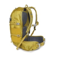
Technical backpack for day trips with backpack cover and internal compartment for the hydration bladder. Ideal daypack for excursions where we need a medium capacity backpack. The back with Air Flow System creates large air channels that will keep our back as cool as possible.

€83,-
Interesting information. I had heard about how flat and easy (up and down) the VdlP was supposed to be, and I kept waiting for the really flat stages. Eventually there were a few through the meseta areas, but I was surprised how few there were. And the Sanabrés definitely had some challenging climbs. So this conforms to my experience last fall. It was pleasing that the VdlP had so much varied terrain.
 
Very interesting data. Is the calculation for the Francés from Roncesvalles?
My gut feeling is that the Sanabres mountain climbs were much easier than the climb to O Cebreiro. But the Via a few challenges like the 10km climb to Monasterio and the one to Albergueria.
The cumulative climb on the Francés is so much more than the Via. That's a bit surprising.
 
A selection of Camino Jewellery

"The Vía de la Plata is fairly flat"​

I've seen people say this and similar several times and since I have all the GPS data at my disposal I decided to calculate it and to do a comparison to the Camino Francés.

Starting altitude in Seville is 9m. Finishing altitude in Santiago is 256m. (256 - 9 = 247)

Total accumulated ascent and descent along the whole route is: ascent +17,116m, descent -16,869m. (17116 - 16869 = 247)

Over a distance of 979km that means an average ascent per km of 17.5m, and an average descent per km of 17.2m.

By way of comparison, the same calculations for the Camino Francés reveal the following:

Total accumulated ascent and descent along the whole route is: ascent +13,331m, descent -13,246m. (13331 - 13246 = 85)

Over a distance of 768km that means an average ascent per km of 17.3m, and an average descent per km of 17.2m.

So actually the difference is very small.

Thanks for the analysis. In my mind it is flatter because especially at the beginning their are such long stretches without much elevation. As opposed to the CF where you start off with quite a first day walk. Loved the VDLP and thanks for the work you do.
 
Great info thanks. Can I assume then the VdLP from Seville is similar to the Mozarabe from Granada to Merida which we did pre Covid ? Loved the Mozarabe but was thinking the Via may be too flat in comparison from previous posts ? Any feedback of Merida to Salamanca also appreciated. Gracias
 
Ideal sleeping bag liner whether we want to add a thermal plus to our bag, or if we want to use it alone to sleep in shelters or hostels. Thanks to its mummy shape, it adapts perfectly to our body.

€46,-
Interesting information. I had heard about how flat and easy (up and down) the VdlP was supposed to be, and I kept waiting for the really flat stages. Eventually there were a few through the meseta areas, but I was surprised how few there were. And the Sanabrés definitely had some challenging climbs. So this conforms to my experience last fall. It was pleasing that the VdlP had so much varied terrain.

We must have walked different VdlP routes :oops:

Mine was fairly flat from Sevilla to Astorga.
Some ..........flat as a pancake.

There were a few short hills, prior to Almaden, out of Banos, etc, but generally........fairly .......flat.

Obviously as @geraldkelly has pointed out, it gets hilly on the Sanabres section into Santiago.
 
Great info thanks. Can I assume then the VdLP from Seville is similar to the Mozarabe from Granada to Merida which we did pre Covid ? Loved the Mozarabe but was thinking the Via may be too flat in comparison from previous posts ? Any feedback of Merida to Salamanca also appreciated. Gracias

Hmmm. Merida to Salamanca..............fairly flat :rolleyes:
Enough small hills, some days, so you don't feel like you are walking across a billiard table.
Though a few days are close to that.
If you look at the profiles on Gronze, which I found to be fairly accurate.

The days with hills are generally a maximum of 200-250 metres (all day), other than after Banos which is 200, and a long slow uphill of 200 into Banos.

I was thinking what a great route it would be for my wife who doesn't like hills.

There is nothing at all, like on the CF day 1 out of St Jean, or going up to O Cebreiro.
 
Last edited:
Get a spanish phone number with Airalo. eSim, so no physical SIM card. Easy to use app to add more funds if needed.
If you had turned left and taken the Sanabres you would have found something very like those eventually.

Yes, I understand that.
But does that make the VdlP 'not' flat.
I suppose it depends if we deem the VdlP to include the Sanabres, or to end at Astorga.
I was always of the belief, maybe wrongly that the VdlP ended in Astorga.
Happy to be corrected :oops:

It would be interesting to see the stats for the VdlP up until Astorga,
or at least to the the turn off for the Sanbres at Granja.

Maybe in your analysis @geraldkelly you have that already? ;)
 
Last edited:
My first time on the VDLP I was feeling quite lonely with very few pilgrims from Salamanca and no English speakers so I decided to walk to Astorga. I found it flat and boring. Never again!
I was so happy on the last day to see in the distance ahead to my right ,the green ,metal bridge/footpath on the Frances.
However things have definitely changed and many more pilgrims and English speakers now walk .
I now always turn off onto the Sanabrese.
 
St James' Way - Self-guided 4-7 day Walking Packages, Reading to Southampton, 110 kms
Yes, I understand that.
But does that make the VdlP 'not' flat.
I suppose it depends if we deem the VdlP to include the Sanabres, or to end at Astorga.
I was always of the belief, maybe wrongly that the VdlP ended in Astorga.
Happy to be corrected :oops:

It would be interesting to see the stats for the VdlP up until Astorga,
or at least to the the turn off for the Sanbres at Granja.

Maybe in your analysis @geraldkelly you have that already? ;)
What I discovered from my analysis is that the "Via" from Seville to Santiago via Ourense has about the same amount of ascents and descents per km and the Frances from Saint-Jean to Santiago.

Whether that makes it flat or not is a question of opinion.

Granja to Astorga is very flat, basically Meseta.
 
Yes, I understand that.
But does that make the VdlP 'not' flat.
I suppose it depends if we deem the VdlP to include the Sanabres, or to end at Astorga.
I was always of the belief, maybe wrongly that the VdlP ended in Astorga.
Happy to be corrected :oops:

It would be interesting to see the stats for the VdlP up until Astorga,
or at least to the the turn off for the Sanbres at Granja.

Maybe in your analysis @geraldkelly you have that already? ;)
Seville to Granja de Moreuela

Distance = 611km
Start altitude = 8m, end altitude = 709m
Total ascent = +8968
Total descent = -8267
8968 / 611 = 14.6m ascent by km
8267 / 611 = 13.5m descent by km

So less hilly, yes, but not really flat.
 
My first time on the VDLP I was feeling quite lonely with very few pilgrims from Salamanca and no English speakers so I decided to walk to Astorga. I found it flat and boring. Never again!
I was so happy on the last day to see in the distance ahead to my right ,the green ,metal bridge/footpath on the Frances.
However things have definitely changed and many more pilgrims and English speakers now walk .
I now always turn off onto the Sanabrese.

Funny how we all perceive and enjoy things differently.
I loved that section, particularly on the Via Verde up to Astorga. (old rail track)
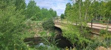
Paddling in the steam before Alija....

But I do love mountains.
Heading over to the Invierno was heaven.

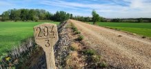
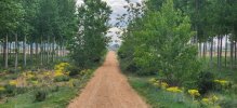
Think these pics are from the last 2 days of the VdlP into Astorga.
Yes, very flat. But I still enjoyed it.

Day-33-Benavente-to-Alija14.jpg
Day-34-Alija-to-La-Baneza-21.jpg
Day-34-Alija-to-La-Baneza-22.jpg
 
The one from Galicia (the round) and the one from Castilla & Leon. Individually numbered and made by the same people that make the ones you see on your walk.
What I discovered from my analysis is that the "Via" from Seville to Santiago via Ourense has about the same amount of ascents and descents per km and the Frances from Saint-Jean to Santiago.

Whether that makes it flat or not is a question of opinion.

Granja to Astorga is very flat, basically Meseta.

Sorry, not trying to be obtuse.
I was merely curious if the effect of the hilly 'Sanabres' section, skewed the stats to make the earlier VdlP section plus the Sanabres combined, appear to be as hilly as the Frances.
But no matter. :)

It's a great walk, that all that matters...........
Sorry if my question was irritating. :(
It was an interesting question. I was happy to oblige.
 
The focus is on reducing the risk of failure through being well prepared. 2nd ed.

Most read last week in this forum

After a smooth and uneventful flight from Chicago to Madrid on Iberia, the last three days we have been doing some sightseeing in Salamanca and Zamora, and our days have been sunny, a little cool...
After 13 days of walking I've finished my 337km walk on the Camino Sanabres, and my entire 1400km walk from Almería. Yay! If anyone's interested in a day-by-day report, you can find it on my...
Hello, Has anyone travelled by train or bus from Santiago to Zamora on to Granja de Moreruela, I've checked online and it seems there is a train from Santiago to Zamora. I will be flying from the...
One route looks a bit steeper, one a bit longer (not much). How else are they different? Recommendations?
I left them on the trail about 4-5 k before Cea I expect to be in Santiago on April 27-28. Mu email is written on the sides of the poles (for just this eventuality). If you find them and we can...
I think I’m on day 12, so not quite two weeks in. Thus far the VDLP is definitely a different animal than the CF. And I have to say, I’m struggling to enjoy it as much as the CF last year. I...

❓How to ask a question

How to post a new question on the Camino Forum.

Forum Rules

Forum Rules

Camino Updates on YouTube

Camino Conversations

Most downloaded Resources

This site is run by Ivar at

in Santiago de Compostela.
This site participates in the Amazon Affiliate program, designed to provide a means for Ivar to earn fees by linking to Amazon
Official Camino Passport (Credential) | 2024 Camino Guides
Back
Top