• Get your Camino Frances Guidebook here.
  • For 2024 Pilgrims: €50,- donation = 1 year with no ads on the forum + 90% off any 2024 Guide. More here.
    (Discount code sent to you by Private Message after your donation)
  • ⚠️ Emergency contact in Spain - Dial 112 and AlertCops app. More on this here.

Search 69,459 Camino Questions

Which route from SJP?

Elm

New Member
Time of past OR future Camino
June (2018)
I plan to start from St Jean in mid May. Will be walking with my nephew. He’s 18. I’m 70, so there will be a difference in speed. I have been training, but don’t think I’ll be able to do more than 15 km daily. I think I could do St Jean to Orrison, but not sure about the next day on to Roncevales. I do have a heart condition that is stable right now, but endurance could be a problem. I know I can do 5-6 miles at a time, and have been doing some climbing in New Mexico at elevations of up to a mile without difficulty. Just took it nice and slow. But it was not as long a hike as those I anticipate in Spain.

If I start the Napoleonic Route and get too exhausted en route from Orrison , are there options? Any suggestions welcome
 
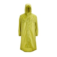
Very light, comfortable and compressible poncho. Specially designed for protection against water for any activity.

Our Atmospheric H30 poncho offers lightness and waterproofness. Easily compressible and made with our Waterproof fabric, its heat-sealed interior seams guarantee its waterproofness. Includes carrying bag.

€60,-
Hi, Elm, and welcome to the Forum.

Short answer: If you decide you can't go on once you get to Orisson, you can taxi or shuttle back down to St Jean. Then you can arrange a bus or shuttle to take you to Roncesvalles, most likely the next day.

Given what you posted, I would strongly encourage you to start out of Roncesvalles. The miles of walking uphill are long, followed by a very steep descent into Roncesvalles. here is a step-by-step video showing what the route to Roncesvalles is like.

 
St James' Way - Self-guided 4-7 day Walking Packages, Reading to Southampton, 110 kms
There's also the option of going through Valcarlos, instead of taking the Napolean Route. It's about 12 km from SJPdP (lots of hills, though, and the last 1/2km is a steep, 60m drop and climb). The climb over the pass the next day is easier, too.
 
There's also the option of going through Valcarlos, instead of taking the Napolean Route. It's about 12 km from SJPdP (lots of hills, though, and the last 1/2km is a steep, 60m drop and climb). The climb over the pass the next day is easier, too.

Good points., Geodoc.

Overall, the Valcarlos Route has more elevation gain and loss than Napoleon, and the last climb is steeper, though not as long, as that on Napoleon.

Step-by-step walking Valcarlos (with a bit missing due to heavy rain)

Part one:

Part Two:
 
In 2016, at age 65, I stayed the night at Orrison and began an early day, via the Napoleon. Had trained quite a bit at near sea level. Affected by the gain in altitude, unable to continue after several kilometers, I returned to Orrison. It was mid-morning. They kindly called for a cab, which arrived 1 1/2 hours later and carried me to Roncesvalles. I do not remember the actual cost, but $100 (US) sounds about right. We did not have to go back to SJpDP, but took a shorter route along the ridgeline. The remainder of the pilgrimage was not nearly as physically taxing, although not always easy. Buen Camino!
 
The one from Galicia (the round) and the one from Castilla & Leon. Individually numbered and made by the same people that make the ones you see on your walk.
I second what Davebugg recommended above. Send your nephew off onto Orisson and have another tourist day at SJPdP. Then, take the bus or a shuttle over to Roncesvalles and meet him there. Check with Express Bourricot for this service and others.

That said, the tough part of the first day is the 8 km walk up to Orisson. It talks 2.5 - 3 hours.

The next morning, the walk over the frontier into Spain and down to Roncesvalles is relatively easy, at least IMHO.

Hope this helps.
 
Meet your nephew in Pamplona. It's a beautiful old city and will give you a few days to relax and shake off jet lag. Worse things to do in life than relaxing in Pamplona, Spain right?
 
Get a spanish phone number with Airalo. eSim, so no physical SIM card. Easy to use app to add more funds if needed.
Thanks for all the suggestions. He really wants to walk over the Pyrenees and I don’t want to be a drag on him unnecessarily. So reconnecting at Roncevalles sounds like a good idea. This is his high school graduation present and I want him to enjoy it.
 
In 2017, I pre-planned my first night on the Camino to be at Orrison. Why? To assess my pack, pace, and feet. Even though I trained in the Cascades, it seemed prudent to make this my first stop. I reminded myself this was not a race, and I had plenty of time. I started on April 22nd from SJPdP. I was 75.
 
In 2016, at age 65, I stayed the night at Orrison and began an early day, via the Napoleon. Had trained quite a bit at near sea level. Affected by the gain in altitude, unable to continue after several kilometers, I returned to Orrison. It was mid-morning. They kindly called for a cab, which arrived 1 1/2 hours later and carried me to Roncesvalles. I do not remember the actual cost, but $100 (US) sounds about right. We did not have to go back to SJpDP, but took a shorter route along the ridgeline. The remainder of the pilgrimage was not nearly as physically taxing, although not always easy. Buen Camino!

Just to clarify, when you said affected by the gain in altitude, you are meaning the exertion of the effort? I'm wondering because that section of the Pyrenees is too low to really affect oxygen levels in any meaningful manner.
 
3rd Edition. More content, training & pack guides avoid common mistakes, bed bugs etc
@Elm, from what you wrote I do not recommend you walking from SJPdP to Roncevalles using either way. I've taken GPS tracks and run them through profile makers and the elevation gains and losses to each track's high point are pretty similar for both routes. The Napoleon is up a ridge and is pretty much all up hill (until the point of descent). The Valcarlos is in a valley and there are a lot of ups and downs making a good total of ups.

But here is a suggestion. Go to Roncevalles and spend your first night there. In the morning get the weather report and the two of you take the Napoleon DOWN to SJPdP if the weather is good and the Valcarlos if it isn't (or whatever you or the coin flip decides). The next day you tour SJPdP for awhile and then bus back to Roncevalles while your nephew walks the other way back to Roncevalles. If you can't spend your third night at the Roncevalles albergue (because of your previous stay) then use the hotel or walk to Burgette, just a few kilometers farther. You end up walking the Pyrennes section and your nephew gets to ascent them. I think things will work out well.
 
Last edited:
I think the advice to start in Roncevalles is the smartest thing for you to do. I also think depending on how you do the rest of the way that you may want to taxi or bus to O'Cebreiro. That can be a really difficult day especially if it is raining and the rocks are really wet. Take your time. Do not push it. Walk at your own pace and listen to your body. There are plenty of opportunities to make your stages shorter because of all the services on the CF. When you need to rest, and if you must don't hesitate to call a taxi. If you can't speak Spanish I am sure it will not take long for a Spanish speaking pilgrim to come by to help you.
 
A selection of Camino Jewellery
I am 72 and I truly enjoy the walk up to Orrison. I have done it more than once or twice. Several years ago a good friend who jogs and walks daily said he would share my first day on the Camino with me, he is in good health but only made it as far as the steep muddy cut off and had to thumb back to SJPdP to get his car and return for a beer on the deck about the time I arrived.
My good friend T2A has described it as the worse day you will ever do on the Camino or something to that effect.
I think you should consider all the alternatives being offered here. Let your nephew have an experience he can share with you when you met up in Roncevalles or Pamplona. He will have earned his Camino wings and freinds by then.
 
I understand how difficult it can be to be the cool uncle. I don’t have kids and work hard to try to remain relevant to my nieces and nephews.

This gift you are giving is a huge thing. Your nephew will love it. The beauty of this Camino route is that he can make friends, you can make friends, and your parallel universes can coexist easily.

I recommend you have smartphones capable of texting back and forth. You can coordinate where you plan to stop each afternoon, as well as interim stops for coffee, beer, etc. There is no need to be joined at the hip. Most grown ups traveling with kids on a Camino will tell you that giving them a lot of slack line is a key to mutual benefit. I realize he is 18, but there is still a difference...

Once you get to Roncesvalles, it will become easier for you day by day. By the time you reach other climbs, you will be in vastly better condition. Each day on the Camino serves as training. It is just that first day climb out of SJPdP to get behind you. A LOT of folks start their Camino at Roncesvalles.

I still think letting your nephew have a day's head start and meeting at Roncesvalles is a good thing. As someone said above, meeting at Pamplona is also a good idea.

Hope this helps.
 
Last edited:
While im not 70 and have not heart conditions, I will give my thoughts.

The walk from SJPDP to Roncevalles was IMO one of the highlights of the camino Frances - It is pure nature and beautiful mountains, different from the rest of the camino, and I wouldn’t have missed it for the World. The hardest part is from SJPdP to Orrison as there is a steep ascend that will take the breath out of almost anybody. After Orrison everything is a bit more mild, the roads are great and this is where the Real beauty begins.

In the end the decision is yours alone, as you are the only one who knows your health and fitness. But my advise would be, if possible start at Orrison, or if you truely want to start at SJPDP then spend day 1 getting to Orrison and spend the Night there. I meet plenty of people older than you who did this strategy and it worked well for them
 
Ideal pocket guides for during & after your Camino. Each weighs only 1.4 oz (40g)!
Personally, I would not recommend this whole stage to a person with a heart condition. I did it at 62, and in a section, just before Orisson (even although I had already walked for five days along the Pyrenees), I had to walk 50 meters, stop, recover my breath, then another 50 meters, and again...Feasible, but really tough.
Roncesvalles is a historic and very pleasant place, with many short and relatively easy trekking paths (click here) around the monastery and the woods. So, you can wait for your nephew there, entertain yourself, and get a taste of a walk in the mountains.

I agree (as I wrote in the post just before yours) that the part just before Orrison is REALLY tough. However, I dont feel the stretch from Orrison to Roncevalles is that bad and shouldnt really be avoided - it is a beautiful part of the camino. How did you feel about the stretch.

One can always take a taxi from SJPdP to Orrison and start his camino from there.
 
@Elm, the reason I am not recommending the SJPdP to Roncevalles climb for you is because you said you had a heart condition. I've reworked the profiles from my GPS track data. On both the Napoleon and Valcarlos routes there are 3 km stretches that average a 15% slope. On the Napoleon from the 4.0 km mark to the 7.0 km mark (with an elevation gain of 450 m). The same elevation gain can be seen on the Valcarlos route between the 18.5 and 21.5 km marks. Also note that, although the Napoleon reaches a higher elevation, the cumulative elevation gains are about the same (N=1398 m, V=1359 m).

Maybe you can find an equivalent distance and slope on a road in your mountains near you and give it a drive to see if that is something you should attempt to walk.

Track Statistics

Route Napoleon
  • distance: 25.05 km
  • min/max elev.: 164 m/1432 m
  • elev. gain/loss: 1398 m/-609 m
Valcarlos_Route
  • distance: 22.87 km
  • min/max elev.: 164 m/1059 m
  • elev. gain/loss: 1359 m/-570 m
 
3rd Edition. More content, training & pack guides avoid common mistakes, bed bugs etc
I have done both -the Napoleon (in one day) and Valcarlos (with an overnight in the albergue). The latter (from Valcarlos, in two days) was not particularly difficult to me, I arrived at Roncesvalles feeling good, could have even walked many miles more.
The Napoleon, after Orisson, felt just as a loooong, but not particularly steep ascent. And certainly the views are magnificent, it is very worth the effort.
I was thinking that another possibility to the OP is taxi to Cruz de Thibault (km 15, 6, where the path leaves the paved road, just before Bentartea pass) and walk the not so steep way, 11 km, to Roncesvalles (with the easier final Ibañeta option). That would require some coordination with his nephew...
 
Last edited:
The views whilst walking to Roncesvalles (from St Jean or Orisson) are certainly magnificent BUT bear in mind it could be a foggy or rainy day with no visibility whatsoever ... It does happen, even in Summer.
 
In 2016 my friend and I walked from SJPDP, although she was 69 at the time, superfit and had a lot of hiking, and running, she suffered a heart arrhythmia a few weeks before we left which took her over a month to recover from. Used to being really fit, she hated having to accommodate for her condition.
She just took it really really slowly, small steps, didnt talk to people and just focused on her walk. We would have taxied if she needed to. I was actually quite worried, if it happened again I would start at Pamplona.
 
St James' Way - Self-guided 4-7 day Walking Packages, Reading to Southampton, 110 kms
Just to clarify, when you said affected by the gain in altitude, you are meaning the exertion of the effort? I'm wondering because that section of the Pyrenees is too low to really affect oxygen levels in any meaningful manner.
I am not, myself, but some people are affected by altitude sickness even at elevations where we would not think that possible. My middle son is an example of this
The views whilst walking to Roncesvalles (from St Jean or Orisson) are certainly magnificent BUT bear in mind it could be a foggy or rainy day with no visibility whatsoever ... It does happen, even in Summer.
I was day hiking in The Pyrenees several years ago in the Parque Nacional Ordesa y Monte Perdido and it was snowing. It was July 4th. Weather in the Pyrenees is capricious...
 
I am not, myself, but some people are affected by altitude sickness even at elevations where we would not think that possible. My middle son is an example of this

Altitude sickness is not what was being referred to; I was referring to the OPs concern with cardiovascular O2 uptake and exercise capacity. While some who experience altitude sickness may have compromised performance, they are two separate phenomenon. I saw this difference time and again on Mt Rainier and on Denali.

The section over the Pyrenees on Napoleon is under 5,000 ft. which is well under the elevation that most people will experience even mild symptoms of altitude sickness. It is above 5,000 feet that very few will experience mild symptoms that can last for up to 12 hours. Going from sea level straight to 8,000 feet will have more pronounce moderate symptoms and from 10,000 - 11,000 ft, 75% will have more severe altitude sickness that can last over 24 hours unless they were slowly acclimated. This is the point, too, where complications surrounding pulmonary edema can begin to occur in some.

You did not mention at what altitude your son experiences altitude sickness, but it is highly unusual for that to be an issue below 5,000 feet, though as your son may demonstrate, is possible even if not probable.
 
I plan to start from St Jean in mid May. Will be walking with my nephew. He’s 18. I’m 70, so there will be a difference in speed. I have been training, but don’t think I’ll be able to do more than 15 km daily. I think I could do St Jean to Orrison, but not sure about the next day on to Roncevales. I do have a heart condition that is stable right now, but endurance could be a problem. I know I can do 5-6 miles at a time, and have been doing some climbing in New Mexico at elevations of up to a mile without difficulty. Just took it nice and slow. But it was not as long a hike as those I anticipate in Spain.

If I start the Napoleonic Route and get too exhausted en route from Orrison , are there options? Any suggestions welcome
Hi, day one is tough, but if you can walk 15km a day you will not have a problem. The best thing is ; the toughest day is the first day, then it's plane sailing 👍. You will be fine , the only worry is the weather as it is notoriously unpredictable, you might have perfect weather or you might have hail , snow , rain or all three. Good luck👍👍
 
Technical backpack for day trips with backpack cover and internal compartment for the hydration bladder. Ideal daypack for excursions where we need a medium capacity backpack. The back with Air Flow System creates large air channels that will keep our back as cool as possible.

€83,-
@Elm, the reason I am not recommending the SJPdP to Roncevalles climb for you is because you said you had a heart condition. I've reworked the profiles from my GPS track data. On both the Napoleon and Valcarlos routes there are 3 km stretches that average a 15% slope. On the Napoleon from the 4.0 km mark to the 7.0 km mark (with an elevation gain of 450 m). The same elevation gain can be seen on the Valcarlos route between the 18.5 and 21.5 km marks. Also note that, although the Napoleon reaches a higher elevation, the cumulative elevation gains are about the same (N=1398 m, V=1359 m).

Maybe you can find an equivalent distance and slope on a road in your mountains near you and give it a drive to see if that is something you should attempt to walk.

Track Statistics

Route Napoleon
  • distance: 25.05 km
  • min/max elev.: 164 m/1432 m
  • elev. gain/loss: 1398 m/-609 m
Valcarlos_Route
  • distance: 22.87 km
  • min/max elev.: 164 m/1059 m
  • elev. gain/loss: 1359 m/-570 m
That elevation map is really interesting to me because it illustrates how unreliable memory (mine at least) can be. If anyone had asked I'd have said that the SJPdP to Orrisson section was VERY steep, but the remainder of the route just gently rolling up to beginning of the knee-shattering descent into Roncesvalles. Your map, however, shows a lot of elevation gain after Orrisson which I don't recall at all. Goes to show how much my advice is worth. LOL
 
Hello Elm,

I am a bit younger but not much. Orisson for me, in 2016, was the absolute max for me the first day. 9 hours to get that far. Now, there are two options. Once at Orisson, they will recommend hiring a taxi to take you 8 km to the Cross at the road. From there, Roncesvalles is 10 km. TAKE THE RIGHT PATH at Loepeder as the left is extremely steep.

The other option is to go via Valcarlos. I did this May, 2018 and the climb is not so bad and is pretty well enclosed if bad weather hits. Valcarlos is very accessible for us oldies and is only 10 km from SJPdP. The next day, if you feel the need, a taxi can be ordered to take you to Roncesvalles or even Burgete as the climb to Roncesvalles is about 12 km and Burgete is 3 or 4 km beyond.

Listen to your body, rest when needed, let the feet breathe if they are screaming, ove on when it is time.
 
Hi, Elm, and welcome to the Forum.

Short answer: If you decide you can't go on once you get to Orisson, you can taxi or shuttle back down to St Jean. Then you can arrange a bus or shuttle to take you to Roncesvalles, most likely the next day.

Given what you posted, I would strongly encourage you to start out of Roncesvalles. The miles of walking uphill are long, followed by a very steep descent into Roncesvalles. here is a step-by-step video showing what the route to Roncesvalles is like.

 
3rd Edition. More content, training & pack guides avoid common mistakes, bed bugs etc
Love your video. I have a few questions. Leaving SJPDP, there is only 1 way to get to Orisson - correct?
The following day, from your video, I see 2 options to get to Roncesvalles.
How much shorter is the more difficult one that you took? I’m 71 - had no problems walking CF last 100k last year but don’t enjoy steep
declines at all. Thanks
 
Carolyn, I think you are talking about @davebugg's video on this thread's second post. Dave actually took the longer, less steep way. The steep way is 4.0 km to Roncesvalles. The longer way follows the road to Puerto Ibaneta. That is also 4.0 km but then it is 1.3 km more to Roncevalles.

At 34:00 in the video Dave shows what is labelled the shortest way and he takes it. At 34:30 you see a sign post. That actually tells you the easier way is the path to the right but many people get confused here anyway. Dave continues on the short way though so you can see (at 34:40) where, back on the road, the steep way, a trail, is across the road heading down into the forest. He also points the camera to the right down the road with a label indicating that is the easy way. That is the way his walk continues.

The trail to the right at the signpost at 34:30 will meet the road later on. So, to take the least steep way, take a right at the sign post or, past that, take a right at the road.

It is possible to slow down youtube videos. That will be helpful in the 34:00 to 35:00 timeframe.
Thanks for explaining that, Rick. :)🤞
 
3rd Edition. More content, training & pack guides avoid common mistakes, bed bugs etc
The Napoleon route is stunningly beautiful however in your condition I wouldn’t do it. Not to scare you but a gentleman with a known heart condition lost his life to his condition steps past Orrison. It was the day before I arrived at Orrison in May 2016. I’m wondering if you want to start at SJDP could you take a scenic drive by taxi over the Napoleon route or alternate route. Just please don’t risk it. It’s a short walk to Orrison .... the views are a walk up to heaven....the climb feels like you are.
Buen Camino ❤️
 
Lots of good advice above. I think starting in Roncesvalles makes sense.

But...........

If you wanted to experience the Pyrenees, and the weather was OK, you could do part of it.

The first section to Orrison is quite strenuous and you have a long drag uphill after that.

Why not just take the Mountain shuttle to the top? ( Croix Thibault )
Scroll down this page: https://www.expressbourricot.com/persons-transport/
Then you have a 10 km walk across the top and down
(take the RH path on the downhill from Col Lepoeder as it's easier)

If the weather doesn't look good at the top, stay on the shuttle and go back down to St Jean.
They will probably have a shuttle going to Roncesvalles or you can get a regular taxi from St Jean to Roncesvalles.
 
Get a spanish phone number with Airalo. eSim, so no physical SIM card. Easy to use app to add more funds if needed.
Lots of good advice above. I think starting in Roncesvalles makes sense.

But...........

If you wanted to experience the Pyrenees, and the weather was OK, you could do part of it.

The first section to Orrison is quite strenuous and you have a long drag uphill after that.

Why not just take the Mountain shuttle to the top? ( Croix Thibault )
Scroll down this page: https://www.expressbourricot.com/persons-transport/
Then you have a 10 km walk across the top and down
(take the RH path on the downhill from Col Lepoeder as it's easier)

If the weather doesn't look good at the top, stay on the shuttle and go back down to St Jean.
They will probably have a shuttle going to Roncesvalles or you can get a regular taxi from St Jean to Roncesvalles.
Thanks to everyone for all the information and suggestions. I see that I have many options depending on how I feel, the weather, and my cardiologist’s instructions. I feel much reassured about the start of this journey. I don’t feel bound to prove anything. And I don’t mind a bus or taxi occasionally if necessary.
 
Given what you posted, I would strongly encourage you to start out of Roncesvalles. The miles of walking uphill are long, followed by a very steep descent into Roncesvalles. here is a step-by-step video showing what the route to Roncesvalles is like.


Dave, I so enjoyed watching the video, and have found the whole series now on YouTube, thanks. I relived the whole exhilarating experience.
I loved the pauses where you stop and look around and take it all in. The fly-over at the beginning was a revelation to a computer non-savvy like me. Great contribution !

Thanks, Paul. . .

All I did was record the video footage, and I used the Walkmeter app to record the GPS track. It was John Sikora who worked his magic with the post production and editing. He used my Walkmeter files to do both the overlay on the Google Maps flyover stuff, and the overlay progress marker on the Brierley stage map. John is a wizard at that stuff. :)
 
3rd Edition. More content, training & pack guides avoid common mistakes, bed bugs etc
In 2017, I pre-planned my first night on the Camino to be at Orrison. Why? To assess my pack, pace, and feet. Even though I trained in the Cascades, it seemed prudent to make this my first stop. I reminded myself this was not a race, and I had plenty of time. I started on April 22nd from SJPdP. I was 75.
I will be starting Sept 18 on my 77 th birthday. I have planned my Camino to be in Orisson that evening and continue on to Ronsavellas the next day. Will be going very slow. Will hook up with my wife on Oct 15 in Leon and finish whenever.
 
The first edition came out in 2003 and has become the go-to-guide for many pilgrims over the years. It is shipping with a Pilgrim Passport (Credential) from the cathedral in Santiago de Compostela.
There is not only the Albergue in Orisson to split the etappe over the Pyrenees.

Please look here:


For me it was at my first walk over the Pyrenees like "the hell" to walk downhill suddenly for the last four kilometers at the end.

But at the top, at Collado de Lepoeder, you can choose, if you want to walk through the forest straight ahead or, going to the right side, to walk over a little street.
We walked the street, not steep downhill, not slippy, and cäme to the national street to the way from Valcarlos. In addition its only 400 meters more, but if it´s rainy or you have problems with your knees, it´s much better to walk.
 

Most read last week in this forum

Hi Caminantes, My wife and I are leaving for Madrid from Brisbane - AU on May 4th to walk the Frances. We are flying with Qatar. I am a bit worried that if I check in my backpacks, they have a...
Hi all, Im walking my first Camino in April (CF) and was wondering if it would be likely for me to encounter leeches? I know for most people leeches are not a big deal but they are in plague...
In past years, when we walked from Samos to Sarria, there was simply a yellow arrow that went off to the right of the highway, up a hill, past a pig farm then a sharp left turn at a small church...
Are you also interested to know the reasons why other fellow pilgrims choose to walk El Camino? Please participate in the poll!
Several local websites have reported a small earthquake this afternoon with an epicentre in the Sarria area. Apparently felt quite strongly locally but with little likelihood of property damage...
Hello!! I am a retired Spanish gentleman living in Madrid. My name is Jose and I would like to do the Camino de Santiago again!!! But this time I would like to walk and improve my English Level...

❓How to ask a question

How to post a new question on the Camino Forum.

Forum Rules

Forum Rules

Camino Updates on YouTube

Camino Conversations

Most downloaded Resources

This site is run by Ivar at

in Santiago de Compostela.
This site participates in the Amazon Affiliate program, designed to provide a means for Ivar to earn fees by linking to Amazon
Official Camino Passport (Credential) | 2024 Camino Guides
Back
Top