• Remove ads on the forum by becoming a donating member. More here.

Search 74,075 Camino Questions

how steep is the climb on the first day

russ russell

New Member
Time of past OR future Camino
want to walk this year either in april/may or september
does anyone have any photos or information on how hard the first day is when leaving from st.jean.. I am not sure if I should do the whole camino or start in Pamplona. so if anyone can help I would be very grateful . I believe the walk from st.jean is very steep to climb. is this true.?
 
€2,-/day will present your project to thousands of visitors each day. All interested in the Camino de Santiago.
If your starting in Pamplona your still doing the whole camino, your camino. If your not comfortable with the "climb" out of St Jean, Pamplona is a great option to start. Or Roncesvalles, that is also an option.


St Jean isn't the starting point of anything. It is just a popular and very touristic place to begin for many people.
St Jean to Roncesvalles isn't as hard as some make it out to be and there are options. Walk the Valcarlos route instead of Napoleon, stay in Orrisson for the first night ect ect... or just walk in your pace, on foot in front of the other, don't rush and in then you will also make it in one day. Many people, alot older than you, have done it, so why would you think you could not?
But again, Roncesvalles or Pamplona are also great places to start.

I would say ANY place is a good place to start.
 
Last edited:
Ideal sleeping bag liner whether we want to add a thermal plus to our bag, or if we want to use it alone to sleep in shelters or hostels. Thanks to its mummy shape, it adapts perfectly to our body.

€46,-
Pictures don't do it justice because they make it look relatively flat. Trust me it is not but just keep climbing and keep climbing one foot step at a time and you'll get to the top. It is highly recommended to make a reservation at Refuge Orisson for the first night after you have tested your legs for the first 7km. It leaves you 20 km to continue on up the hill and downhill (a killer) to Roncevalles.
 
We have to drop the media induced notion that the Camino starts in Saint Jean Pied-de-Port. It starts anywhere. Many people walk out their front door in France or Switzerland or Spain and start walking. We non Europeans pick a spot.
 
The Napoleon route from St. Jean is a challenging walk. You need to use common sense here. Most people do struggle over successfully, the young and fit bound over, there is the occasional heart attack.
 
...and ship it to Santiago for storage. You pick it up once in Santiago. Service offered by Casa Ivar (we use DHL for transportation).
images.webp
It's very steep Russ - and the descent is also pretty tough. The views are spectacular on a clear day and it's a very rewarding experience. We are of average fitness and we managed it in one (long!) day. However, as others have said, it's just one of many options for beginning your Camino.

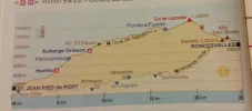
Edit - the walk really isn't as bad as the graphic suggests. The paths don't follow the steep gradient - they zig-zag, if that makes sense. You aren't actually climbing in the true sense of the word, just walking up a very steep hill.
 
Last edited:
The Napoleon route from St. Jean is a challenging walk. You need to use common sense here. Most people do struggle over successfully, the young and fit bound over, there is the occasional heart attack.
No Way! That's my opinion about common sense and heart attacks.
 
I wonder where more heart attacks happen. On the route Napoleon or on the couch at home? Hmm
 
Perfect memento/gift in a presentation box. Engraving available, 25 character max.
does anyone have any photos or information on how hard the first day is when leaving from st.jean.. I am not sure if I should do the whole camino or start in Pamplona. so if anyone can help I would be very grateful . I believe the walk from st.jean is very steep to climb. is this true.?
You may find some information on this thread about the gradients. https://www.caminodesantiago.me/com...ied-de-pont-to-roncesvalle.15174/#post-109186. Just to give you a comparison, by my reckoning, a gradient of 35% requires 'scrambling,' and there is nothing even remotely near that on the Camino. Hope this helps.
 
Last year at 66 I was going to be sensible and take 2 days on the Valcarlos route. However everyone in the Albergue was doing the Napoleon in one day (Orisson was closed), so I did too. Sure it was long and tiring but totally do-able. I did send half my stuff by transport for that first day, and I found companions to stay nearby. I must say, however, that I had no back/leg/medical conditions to consider, the weather was good, and I am not averse to a bit of discomfort. Having very little load and going slow but steady got me there.

That said, I agree that it makes perfect sense to start elsewhere, especially if you have lurking health issues, a schedule to meet or if the weather is bad.
 
3rd Edition. More content, training & pack guides avoid common mistakes, bed bugs etc
does anyone have any photos or information on how hard the first day is when leaving from st.jean.. I am not sure if I should do the whole camino or start in Pamplona. so if anyone can help I would be very grateful . I believe the walk from st.jean is very steep to climb. is this true.?

The Napoleon route could be driven in a car. Most of it is along an existing road. Its not steep. Gradient averages out to about 60 meters per kilometer. The hard part is the distance ... and there is no place to get out of weather. Remember to pack a lunch and enough water. There are harder sections on the camino ... except this is the first day and conditioning is an issue.

My definition of steep is where you need to use a hand from time to time to maintain balance ... Very steep is where you need to use protection.
 
Are
The Napoleon route could be driven in a car. Most of it is along an existing road. Its not steep. Gradient averages out to about 60 meters per kilometer. The hard part is the distance ... and there is no place to get out of weather. Remember to pack a lunch and enough water. There are harder sections on the camino ... except this is the first day and conditioning is an issue.

My definition of steep is where you need to use a hand from time to time to maintain balance ... Very steep is where you need to use protection.
Are we talking about the same route. Yes, you can drive as far as the cut off to the Font de Rolland then you are into walking terrain. I have seen cars on the Spanish side but they are only 4WD.
 
Are

Are we talking about the same route. Yes, you can drive as far as the cut off to the Font de Rolland then you are into walking terrain. I have seen cars on the Spanish side but they are only 4WD.

Using google earth ... the cut off to Font de Roland is 1220 meters. You might be into walking terrain but thats not because its steep. The path follows old road ... it might not be suitable for driving but only because its not maintained.
 
A selection of Camino Jewellery
does anyone have any photos or information on how hard the first day is when leaving from st.jean.. I am not sure if I should do the whole camino or start in Pamplona. so if anyone can help I would be very grateful . I believe the walk from st.jean is very steep to climb. is this true.?
IMO, the very first day 's hike from Saint Jean Pied de Port was quite challenging: quite a steep elevation gain to the top followed by a....steep descent on the other side of the mountain! I left St Jean on September 29, 2011 at 6ASM with only a cup of coffee, stopped for lunch at the mountaintop, devoured Basque Ham & Cheese and farmers' bread I took along. Be sure to buy food & provisions in town the day before you leave as all shops are closed early morning! Bon voyage!
 
...and ship it to Santiago for storage. You pick it up once in Santiago. Service offered by Casa Ivar (we use DHL for transportation).
does anyone have any photos or information on how hard the first day is when leaving from st.jean.. I am not sure if I should do the whole camino or start in Pamplona. so if anyone can help I would be very grateful . I believe the walk from st.jean is very steep to climb. is this true.?
I guess the answer would depend on how fit you are?
I saw young pilgrims practically skip over the Pyrenees the first day. Some of the older or less fit crash at Orisson for the night and go into Roncesvalles the next day.
I suppose I would fall in the middle condition wise, and I had no problem getting to Roncesvalles the first day. I just took my time. Took breaks. Smelled the roses. In fact, I stopped in Roncesvalles only for a beer and walked an additional 3 km to Burguete and spent the night there.
 
I agree with Russ, this will be YOUR Camino, SO ignore all the white noise and do what is comfortable to YOU - don't try to keep up with anyone. - Easy does it. The Camino is not a race, it is a (spiritual) journey.
 
does anyone have any photos or information on how hard the first day is when leaving from st.jean.. I am not sure if I should do the whole camino or start in Pamplona. so if anyone can help I would be very grateful . I believe the walk from st.jean is very steep to climb. is this true.?

It's long if you do it all in one go, but not extremely steep. The way down to Roncesvalles is shorter and (therefore) steeper.
 
The one from Galicia (the round) and the one from Castilla & Leon. Individually numbered and made by the same people that make the ones you see on your walk.
Both ascent and descent are steep. If you are fit and accustomed to walking with a pack, you will be able to do it. If you are not, you may still be able to do it. Nobody can really answer this question for you.
 
3rd Edition. More content, training & pack guides avoid common mistakes, bed bugs etc
St Jean isn't the starting point of anything. It is just a popular and very touristic place to begin for many people.
Why do people say it is not the start of anything? It's the start of the Camino Frances, just like Santiago is the end of it and Le puy is the start of another, and Arles is the start of another. Your Camino can start anywhere, but if you want to do the CF, then SJPP it is, or Roncevalles.

As for steepness, it is steep. Unless you are a long legged Dutchman ;0) But it is beautiful, and something for the bucket list. I second splitting the day by staying in Orisson if you are not sure you can do it in one day. And I second taking it at your speed, resting when you need, walking at your rythm.
 
If YOU start YOUR Camino in Burgos, then the start of the CF is in Burgos. And Santiago isn't always the end of it. Some people will walk as far as Leon and stop. Or further on to Finisterre. It is an individual thing. Originally the Camino de Santiago started from your front door. You're just naming a certain route - and even that route has by ways and off shoots.
 
I agree with Russ, this will be YOUR Camino, SO ignore all the white noise and do what is comfortable to YOU - don't try to keep up with anyone. - Easy does it. The Camino is not a race, it is a (spiritual) journey.
That is the right attitude! Thank you Emily. :)
 
Ideal sleeping bag liner whether we want to add a thermal plus to our bag, or if we want to use it alone to sleep in shelters or hostels. Thanks to its mummy shape, it adapts perfectly to our body.

€46,-
No personal passion involved in this, I just think it is interesting how things become accepted as fact.

The Roman road that preceeded the pilgrimage and upon which much of today's route still follows, was the Ab Asturica Burdigalam (according to Wikipedia - please correct me if I'm wrong all you scholars our there). It went over the top - what we call the Route Napoleon - and linked Bordeaux and Astorga. So one could equally and more historically correctly claim the "starting point" is Bordeaux.

Not many medieval pilgrims started walking at SJPDP - only the ones who lived there. It could be argued that any route that starts in France is the Camino Frances.

Names are arbitrary constructs. Ain't language fascinating?
 
We were standing at the foot of the steep climb out of SJPP, on our first camino, when an older man dressed in a bright orange jacket passed by walking at about 1klm per hour, after he was out of hearing range, we had a chuckle about how someone who was "obviously not a great walker", was shuffling along. We threw our packs back on, and set off at a brisk pace.
We never caught him, every time we stopped for a rest & drink, we could see the bright orange jacket, moving at the same pace, around the next "switch back", into the distance, we stopped at Orisson, he didn't.
That was the day we both learnt how to climb steep hills.
Yes, it is steep, but not something to be avoided if you think your fit enough to walk to SDC (plenty of ups & down along the way).
Weather permitting, I'd walk it every time, it's a very beautiful walk.
Buen Camino
Colin
 
A selection of Camino Jewellery
@Annie G my sympathy, for a heart-rending loss. I hope you feel his spirit soaring above on the winds of the camino, when next you walk, and closely beside you when you rest.

And, as a distraction, I love your avatar of a snail atop a tortoise - where did you find it?
 
Last edited:
@Annie G my sympathy, for a heat-rending loss. I hope you feel his spirit soaring above on the winds of the camino, when next you walk, and closely beside you when you rest.

And, as a distraction, I love your avatar of a snail atop a tortoise - where did you find it?

Thank you. What lovely thoughts.
Snail on tortoise? Googled tortoise and snail for slow pokes and there it was.
 
11132241_10203864536154646_935616892_o.webp
does anyone have any photos or information on how hard the first day is when leaving from st.jean.. I am not sure if I should do the whole camino or start in Pamplona. so if anyone can help I would be very grateful . I believe the walk from st.jean is very steep to climb. is this true.?
The climb is not that difficult, people exaggerate. It is just steady 25-30 deg incline. Crossing the Pyrenees is a beautiful start though. If you want you can break that stage by stopping at Orisson.
Alternate lower route has an elevation gain of 750m as opposed to the main route with 1250m, if you were to walk in one go.
 
Last edited:
A selection of Camino Jewellery
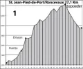
If you plot the same diagram with a different "x" scale, you will see a completely different profile. AS it is drawn it gives a wrong impression as to its actual steepness.

Diagram? My heart and lungs tell me how steep the ascent, my knees how steep the descent.
 
Why do people say it is not the start of anything? It's the start of the Camino Frances, just like Santiago is the end of it.
Your Camino can start anywhere, but if you want to do the CF, then SJPP it is, or Roncevalles.

There you go, you just contradicted yourself by saying "or Roncesvalles". Either there is an 'official' starting point or there isn't. There can't be two. Certainly if the latter is in Spain.
And if 2 IS possible, than 3 or 4 or none is also possible and than we are back at, Sjpp is not the official starting point.

I will just go with the idea of there not being an official starting point other than where ever you are actually starting.
 
The focus is on reducing the risk of failure through being well prepared. 2nd ed.
Diagram? My heart and lungs tell me how steep the ascent, my knees how steep the descent.
Yes of course. One's fitness level makes all the difference. Here we are talking about the steepness of the first stage compared to the rest of the Camino. Most of the climb is on paved roads. If you do this one go, its about 1250m elevation gain. If you break this stage into two and take it slow and steady it is doable as long as you don't have any health issues.
 
If you have any doubt, take two days to go over the Pyrenees by staying at Orisson the first night, a night in the mountains. The main reason is that once you pass Orisson, there is no place to stop until you get to Roncesvalle. The distance wise, Orisson is about 1/3 way to Roncesvalles (at least less than half way). Added bonus is that staying over at Orisson was fun especially the after-dinner program where you get to meet many people who will be walking with you next few weeks). Forcing yourself more than you should on the first day can cause problems that may slow you down and require a few days to recover erasing the time saved by going over in one day.
 
Ideal sleeping bag liner whether we want to add a thermal plus to our bag, or if we want to use it alone to sleep in shelters or hostels. Thanks to its mummy shape, it adapts perfectly to our body.

€46,-
does anyone have any photos or information on how hard the first day is when leaving from st.jean.. I am not sure if I should do the whole camino or start in Pamplona. so if anyone can help I would be very grateful . I believe the walk from st.jean is very steep to climb. is this true.?

Russ:

This is not any easy walk but very doable. The key in my opinion is to take your time. Do not get caught up in another Pilgrims pace. If you are concerned, stay at Orisson the first night. The walk becomes much less difficult if you stop and you get to meet and know other Pilgrims. In regards to Height, I believe it is approximately 1900 meter's or a little over 6,000 feet.

Ultreya,
Joe
 
does anyone have any photos or information on how hard the first day is when leaving from st.jean.. I am not sure if I should do the whole camino or start in Pamplona. so if anyone can help I would be very grateful . I believe the walk from st.jean is very steep to climb. is this true.?


I walked over the Pyrenees, stopping overnight in Orisson, and yes, as someone else has said, sending part of my backpack over by Jacotransport. It was hard, partly because it was the first day or two of my walk. If I had encountered it two weeks later, it would have "felt" easier. Others have given you good advice . . . one step at a time, it's not a race. Or starting from Roncesalles, etc.

But I was very happy I sucked it up. When considering which route to walk for my upcoming second Camino, I thought I might go by way of Valcarlos if I did the Camino Frances again, or whether I'd find the Pyrenees not so intimidating, but I'm walking the Norte this time instead.

I suggest you get John Brierley's book for the Camino Frances. It was invaluable to me, both for seeing the elevations for each "stage", and for other excellent information. I tore the book into three sections, and put each part away after I was finished with it.

I was nearly 67 last time I walked, and I wanted to stick out that first part and overcome the challenge. I did it. Doesn't mean it's the right thing for everyone. And the person who said the diagram is much worse than the path is right. I never felt like I was "climbing" . . . just walking one step at a time up a very steep hill. Hiking poles are also invaluable. I probably saved myself (the clutz) from stumbling/falling at least once every day, due to the stablizing influence of the hiking sticks.

Buen Camino!
 
View attachment 17620
The climb is not that difficult, people exaggerate. It is just steady 25-30 deg incline. Crossing the Pyrenees is a beautiful start though. If you want you can break that stage by stopping at Orisson.
Alternate lower route has an elevation gain of 750m as opposed to the main route with 1250m, if you were to walk in one go.
Rajy62, I think you may want to re-examine that 25-30 degree figure. The elevation gain from SJPdP to Col de Lepoeder is approximately 1250 meters (1.25 km) over a distance of approximately 19 kilometers, which makes the average slope a little more than 6.5 percent -- that's a climb of 6.5 meters in every 100 meters of horizontal distance, or approximately 3.75 angular degrees. When you look at it that way, it's not nearly as intimidating as the elevation profile chart from the Brierly guidebook makes it appear. You have to make note of the difference between the vertical scale and the horizontal scale in the chart. Imagine stretching the same Brierley guidebook chart out so that both scales were the same as the vertical scale -- the chart would then be almost half a meter wide and the rise would look pretty insignificant. But let's not kid ourselves; for the average pilgrim setting out on the first day, even though he or she may have trained with a backpack over many miles or kilometers in the weeks and months before arriving, it is not exactly a stroll in the park. But no one in reasonably fit condition should have a real problem other than a lot of huffing and puffing and sweating. However, breaking it up by stopping at Orisson is a good idea if you can get a reservation -- not only for physical reasons but because the Orisson communal meal experience sets the stage in such a positive way for the rest of one's Camino.
 
€2,-/day will present your project to thousands of visitors each day. All interested in the Camino de Santiago.
It's all relative. What is steep for one person, might not seem so steep for another. I live near the Rocky Mountains where I've hiked trails with 3000 meter elevation gain, so hiking the Napoleon route up and over the Pyrenees didn't seem too bad. That said, it was still a long walk and I was glad to see Roncevalles!
 
Rajy62, I think you may want to re-examine that 25-30 degree figure. The elevation gain from SJPdP to Col de Lepoeder is approximately 1250 meters (1.25 km) over a distance of approximately 19 kilometers, which makes the average slope a little more than 6.5 percent -- that's a climb of 6.5 meters in every 100 meters of horizontal distance, or approximately 3.75 angular degrees.
Well now, I was not trying to be theoretical but rather to give a sense of the climb difficulty. If you look at the video posted above by pelgrimpaul, the stage looks relatively flat. So, although the average incline could be less but one should anticipate, at most, a steady 25-30 deg uphill.
 
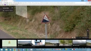
Sometimes in Spain they tell you (actually, vehicles) the grade. Looking back after climbing out of Ourense:
upload_2015-4-8_15-19-31.webp
 
3rd Edition. More content, training & pack guides avoid common mistakes, bed bugs etc
No personal passion involved in this, I just think it is interesting how things become accepted as fact.

The Roman road that preceeded the pilgrimage and upon which much of today's route still follows, was the Ab Asturica Burdigalam (according to Wikipedia - please correct me if I'm wrong all you scholars our there). It went over the top - what we call the Route Napoleon - and linked Bordeaux and Astorga. So one could equally and more historically correctly claim the "starting point" is Bordeaux.

Not many medieval pilgrims started walking at SJPDP - only the ones who lived there. It could be argued that any route that starts in France is the Camino Frances.

Names are arbitrary constructs. Ain't language fascinating?
It would be hard to imagine those Roman engineers running a road over the Napoleon route when the pass through Valcarlos was available. In fact the articles available are confusing. However they do state that the Roman road became the traditional route followed by such as Charlemagne (Carlos in Spanish- hence 'Valcarlos'). I suspect that the Roman road took the lower route.
 
We have some very good historians on this Forum, so let them help us out. IMHO, I suspect the N 135 follows the original Roman route.
I often ask myself about the logistics of a large army moving around Spain, seeking provisions, water, fresh horses, etc. could have ever made their way on 3 meter wide paths.
 
Get a spanish phone number with Airalo. eSim, so no physical SIM card. Easy to use app to add more funds if needed.
For basic history of this area from the middle ages onward and not unfortunately describing the Roman route read this fact sheet in English from the Mayor's office, Saint Jean Pied de Port .

Fellow Forum member Peter Robbins cites two basic sites for further info on the Roman routes which may have been later used by early pilgrims.
" So which routes did pilgrims take in France? As they started from home, the most used routes will have been from the most populated areas. We can assume that pilgrims were keen to visit the major shrines, both those named in LSJ and others. Coste-Messelière's map is the result of research into these, and also shows major church dedications, hostels, etc. We can also assume that they used existing roads, of which the Roman network will have still been a major component; see Gabriel Thiollier-Alexandrowicz's site for an overview map of the main Roman roads, and the Society for Late Antiquity site for more details on the individual roads. So if a route runs from/through populated areas, passes shrines, and uses a well-established road, the chances are it was an important pilgrim route."

G. Thiollier-Alexandrowicz-'s site states
"A Roncevaux, prendre au monument de Charlemagne le chemin de Compostelle établi sur les hauteurs comme la voie romaine; balisé, il passe par le col de Bentarte (1337 m) et rejoint Saint-Jean-le-Vieux (20 km à pied; suivre le GR 65 jusqu'à un carrefour avec la D 302 au nord d'Uhart-Mixe (24 km) en passant par la stèle de Gibraltar à Ostabat, borne des chemins de Compostelle, rejoindre par Saint-Palais Garris (5 km de petites routes). L'itinéraire passe ensuite par Viellenave-sur-Bidouze et Arancou (D 256), et gagne Peyrehorade à 25 km au nord; visiter au passage Sorde-l'Abbaye offrant une mosaïque romaine (4 km Aller-retour). Dax est à 22 km de petites routes par Cagnotte, Bénesse et Saint-Pandelon."

Thus we might open our maps of the area and plot the old Roman route.


Last edited:
Here we are talking about the steepness of the first stage compared to the rest of the Camino.

Are we? I don't see anything about compared to the rest of the Camino in the OP. And remember, this is the first day of the Camino for the OP.
 
Get a spanish phone number with Airalo. eSim, so no physical SIM card. Easy to use app to add more funds if needed.
Are we? I don't see anything about compared to the rest of the Camino in the OP. And remember, this is the first day of the Camino for the OP.
The original question was whether one should consider starting in Pamplona instead, because it might be too steep to climb on the 1st stage. As has been pointed out by others, expect even more difficult terrain further in the Camino. Unless one has any underlying physical issues, knees/joints/back etc, it is doable and rewarding walk to try. If the elevation gain/distance is too much to handle on the "first stage" then split it into two stages. We all have varying fitness levels, only Russ could decide which starting point is best for him.
 
Well now, I was not trying to be theoretical but rather to give a sense of the climb difficulty. If you look at the video posted above by pelgrimpaul, the stage looks relatively flat. So, although the average incline could be less but one should anticipate, at most, a steady 25-30 deg uphill.
And the point I was trying to make was not to be critical of your comment, but rather to note that to one who casually looks at the elevation profiles in the guidebooks, the grades appear to be much steeper than they actually are. When I said the average grade out of St Jean is 6.5%, there are obviously sections that are steeper than that, as well as sections that are less steep. And there are a few short sections that are actually downhill. Nevertheless, it is a strenuous walk for most (myself included).
 
And the point I was trying to make was not to be critical of your comment, but rather to note that to one who casually looks at the elevation profiles in the guidebooks, the grades appear to be much steeper than they actually are. When I said the average grade out of St Jean is 6.5%, there are obviously sections that are steeper than that, as well as sections that are less steep. And there are a few short sections that are actually downhill. Nevertheless, it is a strenuous walk for most (myself included).
I agree average grade is not that meaningful here. But elevation gain reflects the efforts involved, all else being equal. Yes, elevation profiles presented in the guides are distorted. I always look at the actual elevation gain and plan my day accordingly. So, 1250 m gain via the Nepoleon route would be the highest gain of all other suggested stages in Camino Frances. So, yes it is a strenuous walk. Good news is that options exists to either divide the stage into two or take the lower route and therefore reduce the elevation climbed per day before abandoning this section altogether. My 2c.
 
Perfect memento/gift in a presentation box. Engraving available, 25 character max.
I agree average grade is not that meaningful here. But elevation gain reflects the efforts involved, all else being equal. Yes, elevation profiles presented in the guides are distorted. I always look at the actual elevation gain and plan my day accordingly. So, 1250 m gain via the Nepoleon route would be the highest gain of all other suggested stages in Camino Frances. So, yes it is a strenuous walk. Good news is that options exists to either divide the stage into two or take the lower route and therefore reduce the elevation climbed per day before abandoning this section altogether. My 2c.
Amen.
 
Hi All,
Has anyone had luck making a reservation at Orisson? I have emailed twice (email was rejected) and sent comments in through the website option. I am using this website http://www.refuge-orisson.com/en/ Is there another way or something that I am missing? Thanks so much!

Katie
 
I walked over the Pyrenees, stopping overnight in Orisson, and yes, as someone else has said, sending part of my backpack over by Jacotransport. It was hard, partly because it was the first day or two of my walk. If I had encountered it two weeks later, it would have "felt" easier. Others have given you good advice . . . one step at a time, it's not a race. Or starting from Roncesalles, etc.

But I was very happy I sucked it up. When considering which route to walk for my upcoming second Camino, I thought I might go by way of Valcarlos if I did the Camino Frances again, or whether I'd find the Pyrenees not so intimidating, but I'm walking the Norte this time instead.

I suggest you get John Brierley's book for the Camino Frances. It was invaluable to me, both for seeing the elevations for each "stage", and for other excellent information. I tore the book into three sections, and put each part away after I was finished with it.

I was nearly 67 last time I walked, and I wanted to stick out that first part and overcome the challenge. I did it. Doesn't mean it's the right thing for everyone. And the person who said the diagram is much worse than the path is right. I never felt like I was "climbing" . . . just walking one step at a time up a very steep hill. Hiking poles are also invaluable. I probably saved myself (the clutz) from stumbling/falling at least once every day, due to the stablizing influence of the hiking sticks.

Buen Camino!


How did you book your reservation at Orisson? I am having trouble through the website. Thanks!
 
3rd Edition. More content, training & pack guides avoid common mistakes, bed bugs etc
How did you book your reservation at Orisson? I am having trouble through the website. Thanks!

Sorry this response is so late. I finally just e-mailed them and got a response. Orisson was booked by that time, but they have a "gite", a little building about 800 meters before you reach Orisson . . . 10 bunk spaces and a couple of "flat beds", with kitchen, a nice patio outside, etc. You still get your breakfast and dinner (if you want it) at Orisson. It's a good alternative, but just about the only one. Hunto, which was mentioned before, is closer to St. Jean Pied-de-Port.
 

❓How to ask a question

How to post a new question on the Camino Forum.

Most read last week in this forum

Anyone had ever encountered any trouble ot unjust behavior from Hospitaleros? If so, what was it and what to do??
I am not a fan of the Camino Francés, I have never walked it and most probabaly never will. (Please don't discuss the pros/cons of this route on this thread). However, despite my strong opinions...
I AM A PLANNER... I was 10 days in on my last camino before I was able to "relax" - that was when I finally had all of my nights booked. Please, do not make this a discussion about "to book or...
Not sure if this is appropriate use of the forum - but I just completed the Camino Frances last week (yay!!!) and bought a souvenir jet/silver ring for myself in Santiago, and the the jet stone...
My wife and I will finish our third camino next June in Santiago de Compostela. We will have approximately a week before we need to be in Lisbon. We are looking for advice for interesting places...

Featured threads

❓How to ask a question

How to post a new question on the Camino Forum.

Featured threads

Forum Rules

Forum Rules

Camino Updates on YouTube

Camino Conversations

Most downloaded Resources

This site is run by Ivar at

in Santiago de Compostela.
This site participates in the Amazon Affiliate program, designed to provide a means for Ivar to earn fees by linking to Amazon
Official Camino Passport (Credential) | 2024 Camino Guides
Back
Top