marianbradley
New Member
- Time of past OR future Camino
- Mid February 2023
i am wondering where to access suitable detailed gps walking maps for the Via de la Plata Camino.
| For 2024 Pilgrims: €50,- donation = 1 year with no ads on the forum + 90% off any 2024 Guide. More here. (Discount code sent to you by Private Message after your donation) |
|---|
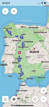
Annoying I haven’t been able to figure out how to do it on the VDLP app….You can download off line available maps through the official Via de la Plata app.
Personally like Bradypus, I'm happy using maps.me.
I have the wise pilgrim app but it doesn’t have gps maps so far as I can tell.If you want something easy, I suggest using a Camino app like Wise Pilgrim or Buen Camino. In addition to maps they have lodging information and historical/cultural info.
A Complete Guide to the Caminos to Santiago de Compostela
A complete guide to the Camino de Santiago, including accommodation on the Camino Francés, Camino del Norte, Camino Portugués, Camino Primtivo, Vía de la Plata, Camino de Invierno, Finisterre & Muxía, San Salvador, Camino Olvidado, Caminho Nascente, Camino da Geira, Camino Inglés, Vía Podiensis...wisepilgrim.com
Camino de Santiago. Guía definitiva: etapas, albergues, rutas
El Camino de Santiago te será mucho más fácil con la guía y la App de la Editorial Buen Caminowww.editorialbuencamino.com
It does. The map is built in and the offline maps are downloadable.I have the wise pilgrim app but it doesn’t have gps maps so far as I can tell.
So it is a map to follow but not a gps guide like google maps, correct?It does. The map is built in and the offline maps are downloadable.
See the help/description on the website https://osmand.net/I was under the impression that there are gps maps operating in real time that can give guidance feedback like google maps during the Camino. The offline maps are simply maps to follow.
What kind of guidance feedback do you need? Do you want to know how much pilgrim traffic there is ahead of you?I was under the impression that there are gps maps operating in real time that can give guidance feedback like google maps during the Camino.
I have downloaded the Gaia app, now to figure out.My partner uses something called gaia gps. It is free, and you can try it out. However when you want to download maps to your phone for offline use, you need the paid version.
He says "The tracks for walking, like the camino stages, can be found on Wikiloc, a spanish app...those tracks can be uploaded to Gaia GPS, and then you are ready to go."
All of that said, I don't recall the VDLP being particularly challenging to navigate. Still, it's nice to have the gps, given that it is available.
Several good apps exist and have been mentioned, but I don't believe there is any "official" app.through the official Via de la Plata ap
So it is a map to follow but not a gps guide like google maps, correct?
I think we're having trouble zeroing-in on the questions and your needs. My knowledge is quite limited, so I can't help much with the answers, but maybe I can help with the questions!I was under the impression that there are gps maps operating in real time that can give guidance feedback like google maps during the Camino. The offline maps are simply maps to follow.
") (If I have mis-stated anything below, feel free to correct me!)
(If I have mis-stated anything below, feel free to correct me!)Thank you for helping to clarify. I am just starting to get experience with these apps as I am downloading and checking them out following the above suggestions.I think we're having trouble zeroing-in on the questions and your needs. My knowledge is quite limited, so I can't help much with the answers, but maybe I can help with the questions!
There are many apps where you download base maps, then download a track (a series of point that looks like a line) to be superimposed on the map, and using the GPS that is on every phone, you can see if you (a moving dot) are still on the line. maps.me is the app I have used.
There are other Camino or hiking specific apps that have already provided their selected tracks and additional information. You may need to go through the process of downloading tracks and/or maps with them, but I haven't used these, so won't comment further.
Perhaps you have heard about Wikiloc, which is a organization with website and an app. Members upload their tracks to the website, so there is a huge collection of tracks available for download. (You can then use those tracks with other apps, if you want.) With the Wikloc app running on your phone, you can "follow" a track and get a sound warning when you deviate from the track.
Which functions are you looking for?
You might be finding a couple of terms confusing here. Maps are a form of geospatial information, ie the information about objects in the space we occupy like where they are, how big they are, and how they link to other objects. Things like hills, roads and buildings are somewhat permanent, so representing them on a printed paper map is easy because they don't really change all that often. Weather systems, tides, and traffic move relatively quickly, so typically they only get displayed 'on screen' where you can see how they are moving in relation to the more fixed objects.i am wondering where to access suitable detailed gps walking maps for the Via de la Plata Camino.
I'm not sure what you think Google Maps will do that other mapping apps don't do. For many people, having access to current information, like traffic, seems to be a big thing. But other mapping apps will do that if that is really important, also at the expense of having a suitable internet connexion which Google relies on the provide this information. This is hardly a real consideration on the camino.I was under the impression that there are gps maps operating in real time that can give guidance feedback like google maps during the Camino. The offline maps are simply maps to follow.
No it certainly isn’t!I'm not sure what you think Google Maps will do that other mapping apps don't do. For many people, having access to current information, like traffic, seems to be a big thing. But other mapping apps will do that if that is really important, also at the expense of having a suitable internet connexion which Google relies on the provide this information. This is hardly a real consideration on the camino.
I use maps.me along with the Camino route downloads from Santiago.nl/downloads. I then use maps.me to pinpoint my accommodation for the night .. helps me to get to my destination at the end of a long day.You can download off line available maps through the official Via de la Plata app.
Personally like Bradypus, I'm happy using maps.me.


Wise Pilgrim Apps are helpfuli am wondering where to access suitable detailed gps walking maps for the Via de la Plata Camino.
Others have referred you to the various apps, that will display the route superimposed on a map and show where you are relative to all that, using your phone's GPS. If you are just looking for the GPS tracks to import into a mapping application that you are used to, you can find the tracks available for download at: http://centrodedescargas.cnig.es/CentroDescargas/loadCamSan.do#i am wondering where to access suitable detailed gps walking maps for the Via de la Plata Camino.
Gronze Maps is still on Beta.You may find Gronze Maps useful! See Gronze.com for more details (in Spanish).
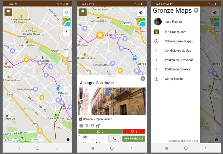
I have installed the app, but it isn't really possible to see how well it works as a navigation aid from here in Australia. The functionality I can use works well. Note that the present version links out to the online Gronze site for further information about accommodation. The advantage is that it is always going to be as current as the main web site while it does this. If you don't want to maintain an internet connection on your phone while walking, it won't work until you get to a place where you can connect back into the internet. There are likely to be quite different views on how much of a limitation this really is.You may find Gronze Maps useful! See Gronze.com for more details (in Spanish).
Good summary and sound advice, df. I too, used both Wise Pilgrim and Camino Ninja on the CP last year, and because I am often distracted by Squirrels!, I needed both to return me to, and keep me on “track”. And, like you, I mourn the loss of Ninja…it was a great app.You might be finding a couple of terms confusing here. Maps are a form of geospatial information, ie the information about objects in the space we occupy like where they are, how big they are, and how they link to other objects. Things like hills, roads and buildings are somewhat permanent, so representing them on a printed paper map is easy because they don't really change all that often. Weather systems, tides, and traffic move relatively quickly, so typically they only get displayed 'on screen' where you can see how they are moving in relation to the more fixed objects.
Global Navigation Satellite Systems (BeiDou/Galileo/GLONAS/GPS/IRNSS/QZSS) provide position, navigation and timing either globally or for a specific region. That is, when you are using a GNSS, it locates you in relation to everything around you - it is your personal piece of geospatial information. The abbreviation GPS, the USAF system that started all this, is commonly used to refer to all these systems on this forum, with little distinction about whether other systems are actually being used.
Together, your personal little bit of geospatial information - your location, speed, etc - allows an application to put you 'on the map', and display that to you. On your smartphone, an app, like IGN maps, OSMAnd or its IOS equivalent, or Wise Pilgrim, will all do this. The trick on the Camino for most of us is to select an app that doesn't rely on an internet connexion through a mobile provider to do all of that. All those mentioned so far work that way. Even Google Maps can be made to work that way, but that isn't how it normally works.
The other bit of geospatial information needed is about where you want to go. In GPS speak, this would be a route, and where you have been would be called a track, but most people will refer to them both as tracks. Today most apps will have the camino routes, along with other walking and cycling routes, already loaded as part of the map. But you can get specific tracks, and a number of track sources exist like wikiloc, one already mentioned.
You mention that the mapping must be 'suitably detailed'. That's a piece of string statement, and only you will be able to tell what is too little or too much information. If you look at John Brierley's guides, his maps don't claim to be any more than a reasonable representation of the general line of the route you need to take, complemented by some more detailed, but often equally representational, maps of towns. The mapping apps mentioned will all be dimensionally accurate, can be scaled down to almost exquisite detail, but might not be all that much more helpful than Brierley's maps during the course of the day.
An app like Wise Pilgrim is customised for a particular route, and will be less useful if you are not following that route. It will show you on the map, but it will also present a wealth of other information about places like albergues, bars and cafes, hostels, etc, all of that drawn from other sources, and then presented to you in the one app. This is a really useful approach for people who don't want to develop higher level navigation skills, and even for those that do.
My thinking for a novice is to select one of the apps based on a specific camino guide and get used to that. Even if you do feel like using a general purpose mapping tool, being able to resort to that camino app will be a useful standby. I loaded Wise Pilgrim and Camino Ninja (no longer available) when I walked the CP last year, and used OSMAnd+ as a general purpose navigation app. There are other general purpose app choices like maps.me, organic maps, etc that seem to work equally well when I have tried them.