Hola,
Arrived in Bilbao this afternoon and walked around for three hours. I've been to Bilbao numerous times so I didn't feel the need to visit tourist sights. It's 33c which surprised me. Last year when here it was definitely much cooler!
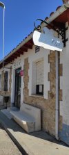
I'm staying at Bilbao Metropolitan Hostel which is close to the Camino. I was here last year. At about €20 it is a very clean (starched sheets!), has a kitchen with free coffee and tea and next door there is a Carrefour supermarkt.
I've already seen a few pilgrims sign in although I assume that they're here to start the Norte or are in the process. I don't expect to see anyone on the Olvidado but one never knows.
I've got my credencial and first stamp from the Cathedral so I'm all set to start tomorrow!
Arrived in Bilbao this afternoon and walked around for three hours. I've been to Bilbao numerous times so I didn't feel the need to visit tourist sights. It's 33c which surprised me. Last year when here it was definitely much cooler!
I'm staying at Bilbao Metropolitan Hostel which is close to the Camino. I was here last year. At about €20 it is a very clean (starched sheets!), has a kitchen with free coffee and tea and next door there is a Carrefour supermarkt.
I've already seen a few pilgrims sign in although I assume that they're here to start the Norte or are in the process. I don't expect to see anyone on the Olvidado but one never knows.
I've got my credencial and first stamp from the Cathedral so I'm all set to start tomorrow!


") )
)
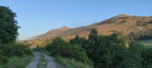
 . More tomorrow.


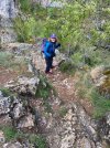
 . Pleased so far with Wikiloc


 )
)


 . I'm embarrassed to say that I don't remember our chat but it warms my heart to know that I helped you at the start. That's what this community (and life) is about
 .
.


 🗺
🗺

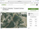
 . I couldn't help myself and asked: how do you know I haven't used it?


 (zoom is not the same thing).


 .
.