- Time of past OR future Camino
- 23:Valença Var Espiritual Apr; Norte Cudillero Oct
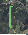
On the 6th of October of this year I walked the official Camino from Soto de Luiña on the Norte. I had been looking forward for months to walking this route por Palancas. I took a left hand turn at the markers toward the mountain. Most Peregrinos take the coastal route forward on the road.
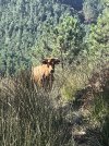
WARNING ️: At this point in time the route is impassable. Grass is knee high and tangles your feet even with poles. In places the grass reached my hat. The thorns reached my waist. The descent was steep and difficult. There were good stretches on the logging road. A big cow trekked me & stood her ground.
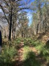
Once you cross AS-268 and enter the woods, the trail which parallels the road becomes much worse. There is a long-standing thick fallen tree that I could not climb over and had to slide down a ravine towards the right holding on to tree branches and then scrambling back up. Pity that TSA confiscated my machete and I had not signed up for an episode of National Geographic. For the first time ever I ran out of water on a Camino despite carrying 2.5 L, this friendly neighbor and her cat so kindly offered me water.
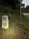
The worst part of it was the vandalism of the mojones, recently placed and at great cost, which were thrown on the ground, some dragged and hidden, some purposely placed in the wrong way. So demoralizing to witness. Thankful for GPS Buen Camino & Wise Pilgrim.
WARNING
️: At this point in time the route is impassable. Grass is knee high and tangles your feet even with poles. In places the grass reached my hat. The thorns reached my waist. The descent was steep and difficult. There were good stretches on the logging road. A big cow trekked me & stood her ground. Once you cross AS-268 and enter the woods, the trail which parallels the road becomes much worse. There is a long-standing thick fallen tree that I could not climb over and had to slide down a ravine towards the right holding on to tree branches and then scrambling back up. Pity that TSA confiscated my machete and I had not signed up for an episode of National Geographic. For the first time ever I ran out of water on a Camino despite carrying 2.5 L, this friendly neighbor and her cat so kindly offered me water.
The worst part of it was the vandalism of the mojones, recently placed and at great cost, which were thrown on the ground, some dragged and hidden, some purposely placed in the wrong way. So demoralizing to witness. Thankful for GPS Buen Camino & Wise Pilgrim.


 . The cat tho!!!!
 Safe travels to you!