annakappa
RIP 2024
- Time of past OR future Camino
- Part frances jun 07/rest frances may- jun 2008/Frances sept-oct 2009/ Sanabres Oct 2010/Frances sept-oct 2011/Aragones Sept-Oct 2012. Hospitalero Sept 2010, Amiga in Pilgrim's Office Oct 2013. Part Primitivo Oct 2013. Portugues from Porto June 2015.
I have ben requested to re-post the directions of the alternate route into Burgos. See below:
Before starting our second Camino, I did a bit of researching regarding the alternative route into Burgos. The distance probably works out the same, but instead of walking through the whole unpleasant factory area, plus all the built up area heading into the city, we tried the following:
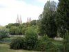
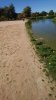
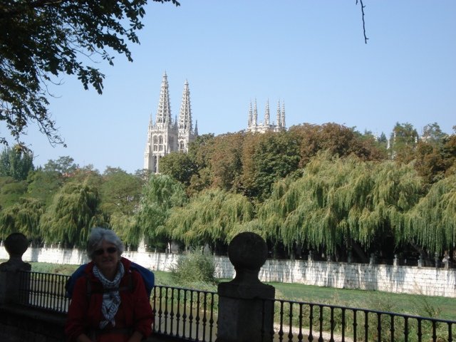
Follow the yellow arrows on leaving Orbaneja Riopico. Cross by bridge over the highway and as you descend the other side, take an immediate left at the side of the first building. Follow this path, which eventually leads you to the perimeter fence of the airport (on your right). After a short walk, you will arrive in the village of Castañares. Cross immediately the main road and walk straight ahead, passing a children's playground, bearing right at a factory, cross a small river by footbridge and the path becomes a small track under trees, running parallel to a highway (on your left). Continue until you see an underpass below the highway, which you take and you then enter an enormous recreational area, which follows the Río Arlanzón all the way to the centre of Burgos (and continues out the other side). You can even walk along a mini beach at one point! Don't be tempted to cross the river by one of the two big bridges for motorized traffic, but wait until you suddenly see the spires of the cathedral just ahead and to the right of you. Take this pedestrian bridge (the 3rd from when you entered the recreational area). Go under the old arch, Puerta de Santa María and you will find yourself standing immediately in the main square in front of the cathedral. The total distance from Castañares is just under 7 kms. The whole track is well signed with yellow arrows and is so much more pleasant than the "official" route. I still wonder why the guide books suggest the other route! Anne
Before starting our second Camino, I did a bit of researching regarding the alternative route into Burgos. The distance probably works out the same, but instead of walking through the whole unpleasant factory area, plus all the built up area heading into the city, we tried the following:
Follow the yellow arrows on leaving Orbaneja Riopico. Cross by bridge over the highway and as you descend the other side, take an immediate left at the side of the first building. Follow this path, which eventually leads you to the perimeter fence of the airport (on your right). After a short walk, you will arrive in the village of Castañares. Cross immediately the main road and walk straight ahead, passing a children's playground, bearing right at a factory, cross a small river by footbridge and the path becomes a small track under trees, running parallel to a highway (on your left). Continue until you see an underpass below the highway, which you take and you then enter an enormous recreational area, which follows the Río Arlanzón all the way to the centre of Burgos (and continues out the other side). You can even walk along a mini beach at one point! Don't be tempted to cross the river by one of the two big bridges for motorized traffic, but wait until you suddenly see the spires of the cathedral just ahead and to the right of you. Take this pedestrian bridge (the 3rd from when you entered the recreational area). Go under the old arch, Puerta de Santa María and you will find yourself standing immediately in the main square in front of the cathedral. The total distance from Castañares is just under 7 kms. The whole track is well signed with yellow arrows and is so much more pleasant than the "official" route. I still wonder why the guide books suggest the other route! Anne


")