• For 2024 Pilgrims: €50,- donation = 1 year with no ads on the forum + 90% off any 2024 Guide. More here.
    (Discount code sent to you by Private Message after your donation)
  • ⚠️ Emergency contact in Spain - Dial 112 and AlertCops app. More on this here.

Search 69,459 Camino Questions

LIVE from the Camino Camino Allerano Boñar-Figaredo

setmeravelles

New Member
Time of past OR future Camino
Camino Vasco-Olvidado-San Salvador 2023
(Note to Mods: Feel free to move this, especially if this Camino takes off and gets its own forum. As it’s a variant of the San Salvador I posted it here.)

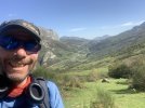
I survived the first day!

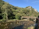
I had breakfast at Cafe Viejo around 7:30 this morning in Boñar after staying in Hostal Nisi. Walked a bit over a km out of town and crossed the cool medievalish bridge. The Olvidado goes left, and the Allerano goes right.

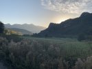
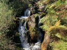
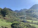
A bit along a rural track before meeting up with the road for about 500 meters. Ender’s Wikiloc goes through Cerecedo and then begins to ascend for the first time along the river. The top had incredible views. I saw some deer below as I began the descent, and they took off when they saw me from afar.

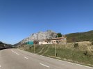
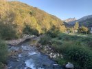
Goes down to the river again, crosses a bridge, and meets up with the road again just outside of Valdecastillo. Google said there was a bar that may have been open, but I wasn’t really wanting to risk to go off trail to find that it was closed or non existent.

About 500 meters later it went up again on a goat trail that didn’t really look like it was even a trail—but it was. After this climb it meets up with a different road and then goes along it (very little traffic) for about 10 km….but with increíble scenery! I met some friendly dogs along the way. It goes through Valdehuesa, which has a restaurant that opens at 12:30 according to Google. I passed it around 10.

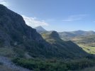
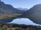
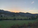
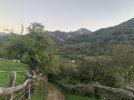
Views just kept getting better and better.

It passed a hamlet, Rucayo, which sort of reminded me of Ruesta on the Aragonés.

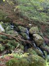
So it appears that Ender may have got lost or off track here. I also had Ray and Rosa’s track, but I know they sometimes use Ender’s. I saw they were different. I went with Ender’s. It went up a steep mountain—forest at least because it was upper 20s C by this time. Then it got to a forest that makes the Olvidado 10B (which I did Tuesday) forest look easy to follow. There was no path. The Wikiloc was going every which way. I eventually found where it went down but was very steep and at one point I had to sit and scoot…safety first. I later had to go through bushes which wasn’t fun.

After that hellish hour, I finally found the nice PR trail and it was all beautiful again. It reminded me of San Salvador between Buiza and Poladura.

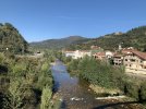
Last 3 Km or so to Puebla de Lillo was along the road.

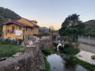
Staying at Hostal Madrid. I think 50€ with desayuno included, haven’t paid yet (apparently at breakfast). I got here at 3:45 and they were still serving lunch thankfully! There are a couple of other places to stay. I think the Hostal Porma was booked but may be just a bit cheaper but without breakfastNo albergue that I know of.

The town has a very basic autoservicio supermarket.

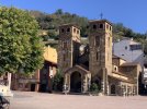
I didn’t see any Romanesque churches, since I know there are a ton of fans here.

No markings—sometimes a PR yellow and white when the track coincided with it. I wasn’t expecting any though.

This has the potential to be a great Camino that links the Olvidado with the San Salvador (near Uxo). But the one part after Rucayo needs to be sorted 🙃

Going to try to upload pics but the wifi is horrible so who knows!

Tomorrow on to Felechosa!
 
Last edited:
The one from Galicia (the round) and the one from Castilla & Leon. Individually numbered and made by the same people that make the ones you see on your walk.
Quick update for Day 2 as bad wifi connection and I am super tired after 33 Km, 800 ascending metres and 1200 descending metres :)

Just gorgeous all the way along. First part was on a PR trail out of Puebla de Lillo, then another one through amazing mountains (shocked myself on the electric fence despite being careful).

The bar in Isoba was closed for October vacations, as was everything in San Isidro and La Raya.

About ten Km of road walking along a fairly busy road (at least for this peregrino!)

La Raya appeared to have an albergue/hotel but it looked as close as the bar and restaurant was right now. This would be where I should have ended the day. I think it was around 17-18 km.

While the second PR that starts in El Fieleta about two km or so into Asturias is amazing and beautiful and stunning, it’s a lot on the same day. The ascent was steep but the views were worth it. Some goat trails around the mountain and that long steep descent. A few abandoned houses on the descent. Two dead horses at the top :( but several more still alive.

Oh, and there were a couple of yellow arrows in this stretch with the yellow/white PR markers! Today was well marked on the trails, but nothing anything Camino.

The descent eventually goes through a beautiful forest with a mountain stream rushing down so waterfalls! Then a trail along a road and the last 3 km on the road. Cuevas has a restaurant, but it was about 1630 so I didn’t try.

Felechosa is a decent pueblo, but half the hotels, restaurants and bars are closed for vacation right now. Keep that in mind. There is an albergue, but I’m at a hotel (Peña Pandos) which is nice but expensive.

Before I forget, last night the individual room at Hostal Madrid was only 40€! The menú del día was 15€. Uff but it was good and not out of the norm price range now.

No Romanesque churches today.

Today May have been my most difficult Camino day ever. It’s right there with my 30 km day on the San Salvador that started in Poladura, and the day I took the hard climb up to San Juan de la Peña on the Aragonés.

Pics tomorrow when I have wifi that my phone will connect to! Or Monday when I get to Oviedo.
 
Pics for the Puebla de Lillo to Felechosa etapa. It’s hard to choose just a few!
 

Attachments

  • IMG_1978.jpeg
    IMG_1978.jpeg
    1.9 MB · Views: 9
  • IMG_2015.jpeg
    IMG_2015.jpeg
    2.3 MB · Views: 7
  • IMG_2024.jpeg
    IMG_2024.jpeg
    846.4 KB · Views: 7
  • IMG_2045.jpeg
    IMG_2045.jpeg
    2.3 MB · Views: 7
  • IMG_2083.jpeg
    IMG_2083.jpeg
    3.1 MB · Views: 6
  • IMG_2125.jpeg
    IMG_2125.jpeg
    5.7 MB · Views: 6
  • IMG_1957.jpeg
    IMG_1957.jpeg
    2.1 MB · Views: 6
  • IMG_2148.jpeg
    IMG_2148.jpeg
    1.2 MB · Views: 6
  • IMG_2202.jpeg
    IMG_2202.jpeg
    3 MB · Views: 5
  • IMG_2190.jpeg
    IMG_2190.jpeg
    3.9 MB · Views: 6
3rd Edition. More content, training & pack guides avoid common mistakes, bed bugs etc
Felechosa to Moreda, my third etapa.

I was a bit sluggish today. Felechosa opens late on Sunday, so I was going on a Coke Zero instead of a café con leche…ah well.

It starts out on a paved rural track that goes to the first village, El Pino. Saw a lovely building that would make a great albergue if it were for sale! Continued on some dirt paths on to Llanos and Collanzo, where a bar supposedly opened at 930 on Sundays, but was out of luck.

After Collanzo it continues on more dirt paths, but alas, it was extremely overgrown, and I just didn’t have it in me to deal with that today. So I went to the road, which was a bit too busy for my liking but at least I didn’t have to fight through plants and stuff! At some point the Camino rejoins the road and takes off again. Wikiloc was a bit off, and I wasn’t sure where I was supposed to be, so I stuck to the road. Maybe not as gorgeous views as from the paths, but it’s Asturias. All the views are gorgeous.

In Levinco, the Camino meets the road again right at an open bar on a Sunday!

An easy and well kept path took me from Levinco to Canañaquinto, which had a lot of places open and a church, though not Romanesque.

From there it’s road the rest of the way to Moreda. There is a 13th century church with a 1.5 Km one way detour I didn’t take.

Moreda…bar in the main plaza (with a pretty church) had a Sunday menu for 12€! And it had Cachopo (Asturias dish). The table next to me was fascinated that I was from the US and doing a Camino and treated me to the post meal café con leche.

It looked like some of the towns have places to stay, even albergues. I took the train up to Figaredo so I can do the last stage of the San Salvador tomorrow and arrive in time to enjoy a city I love, Oviedo.

Today reminded me of the second and third days of the Vasco without the industry and bidigorri (bike path). Also similar to the stage leading to Mieres on the San Salvador.

Let me know if you have any questions! There are a lot of things to work out on this one as I jumped the gun with it a bit I think. It was lovely but challenging, especially physically. If you have done the San Salvador you should be good to go…but with tons more planning.
 

Attachments

  • IMG_2277.jpeg
    IMG_2277.jpeg
    3.4 MB · Views: 6
  • IMG_2397.jpeg
    IMG_2397.jpeg
    3.7 MB · Views: 9
  • IMG_2353.jpeg
    IMG_2353.jpeg
    4.2 MB · Views: 7
  • IMG_2330.jpeg
    IMG_2330.jpeg
    1.1 MB · Views: 7
  • IMG_2318.jpeg
    IMG_2318.jpeg
    4.7 MB · Views: 7
  • IMG_2302.jpeg
    IMG_2302.jpeg
    3.9 MB · Views: 6
  • IMG_2268.jpeg
    IMG_2268.jpeg
    3.2 MB · Views: 7
Thank you for all of your detail and insights!

This looks really interesting, except for the need for all of the planning. I'm usually good with technology, but for some reason I just can't get the hang of Wikilocs or AllTrails. So, that likely takes this one off of my radar for the moment. That's too bad because I am thinking about another San Salvador/Primitivo combo on my own next May. Doing this route instead of the SS could have been an ideal change of pace (though I LOVE the SS).

If anyone hears any more about plans to better mark/maintain this Camino, please share!
 
Very light, comfortable and compressible poncho. Specially designed for protection against water for any activity.

Our Atmospheric H30 poncho offers lightness and waterproofness. Easily compressible and made with our Waterproof fabric, its heat-sealed interior seams guarantee its waterproofness. Includes carrying bag.

€60,-
Great report! I’m just seeing this now, and have been in contact with Ender to ask about the spots in which you had problems. I’ll let you know what I hear.

But just to make sure I‘ve got it right, your problems were primarily in two spots - One after Roncayo and the other after Collanzo.
 
So it appears that Ender may have got lost or off track here. I
I’ve been in contact with Ender about this, and he thinks it sounds like you were using the tracks he recorded while he was searching for the best option for different sections. He has put all the “finished” tracks in a list on his website — did you use those or did you find different separate tracks of his? The list is here.


And for anyone else going there, Ender strongly recommends that you not follow Ray y Rosa’s tracks. The tracks they list for the Olvidado are Ender’s tracks, but for this one, apparently they have linked to some other tracks that Ender says are not good to use.
 
Get a spanish phone number with Airalo. eSim, so no physical SIM card. Easy to use app to add more funds if needed.
The last part is still undefined. From Felchosa to Cabañaquinta it’s fine, but not from there to Ujo. Here is one option — walked by Roderosky (one of my favorite wikiloc members). He did it in 2021.

This is Felchosa to Ujo.

 
I’ve been in contact with Ender about this, and he thinks it sounds like you were using the tracks he recorded while he was searching for the best option for different sections. He has put all the “finished” tracks in a list on his website — did you use those or did you find different separate tracks of his? The list is here.


And for anyone else going there, Ender strongly recommends that you not follow Ray y Rosa’s tracks. The tracks they list for the Olvidado are Ender’s tracks, but for this one, apparently they have linked to some other tracks that Ender says are not good to use.
Those are the tracks I used, the list from his web site and that you linked to.

I figured as he did it in January that the overgrowth wouldn't have been there! The road walking was an okay alternative, as I was not up for bushwhacking that day!

I used roderosky's track as a backup that day. We follow each other on Instagram so I was sorta excited to see him on Wikiloc there :)
 

Most read last week in this forum

(Soon-) Live from the Camino del Salvador - starting end of April 24. We are currently on the Camino de Invierno around 43km before reaching Santiago - from there we will catch a bus to Leon to...
First time posting Live? Left León at 8am. Arrived at Cabanillas 2. The path is very beautiful. 20km total. Followed the River. At first town we went to the lovely Bar and Tienda. I bought cheese...

❓How to ask a question

How to post a new question on the Camino Forum.

Similar threads

Forum Rules

Forum Rules

Camino Updates on YouTube

Camino Conversations

Most downloaded Resources

This site is run by Ivar at

in Santiago de Compostela.
This site participates in the Amazon Affiliate program, designed to provide a means for Ivar to earn fees by linking to Amazon
Official Camino Passport (Credential) | 2024 Camino Guides
Back
Top