• Get your Camino Frances Guidebook here.
  • For 2024 Pilgrims: €50,- donation = 1 year with no ads on the forum + 90% off any 2024 Guide. More here.
    (Discount code sent to you by Private Message after your donation)
  • ⚠️ Emergency contact in Spain - Dial 112 and AlertCops app. More on this here.

Search 69,459 Camino Questions

Better route after Col le Lepoeder to Roncevalles with less road walking?

Time of past OR future Camino
CF September 2022
CF April 2024
Hi All, I will be walking the CF for the second time commencing this coming mid-April. My question is; having taken the path to the right at Col le Lepoeder, is there another option further on that can be taken to eliminate quite a long walk right next to the road down into Roncevalles? We walked in a small group of four last time and didn't see anyone else in front or behind. Thinking there might be a better/safer way for this last part of the stage?
 
Technical backpack for day trips with backpack cover and internal compartment for the hydration bladder. Ideal daypack for excursions where we need a medium capacity backpack. The back with Air Flow System creates large air channels that will keep our back as cool as possible.

€83,-
Hi All, I will be walking the CF for the second time commencing this coming mid-April. My question is; having taken the path to the right at Col le Lepoeder, is there another option further on that can be taken to eliminate quite a long walk right next to the road down into Roncevalles? We walked in a small group of four last time and didn't see anyone else in front or behind. Thinking there might be a better/safer way for this last part of the stage?
I've always taken the (safer) route to the right. When you get to the church there's a path that goes through the woods to the left.
 
That left hand path goes through a very nice section of woods, but can be a bit treacherous if the weather has been wet given it is steep and the footing can be uneven. Both will get you to Roncevalles in about the same amount of time
 
New Original Camino Gear Designed Especially with The Modern Peregrino In Mind!
Hi All, I will be walking the CF for the second time commencing this coming mid-April. My question is; having taken the path to the right at Col le Lepoeder, is there another option further on that can be taken to eliminate quite a long walk right next to the road down into Roncevalles? We walked in a small group of four last time and didn't see anyone else in front or behind. Thinking there might be a better/safer way for this last part of the stage?
Yes there is a dirt track/ditch beside the road. Not sure if it's safer. A dirty slippy stoney affair. I'll take the road next time
 
Join our full-service guided tour and let us convert you into a Pampered Pilgrim!
This promises to become a long and confusing thread. 😉

You are discussing two different roads: road NA-2033 from the Lepoeder pass to the modern Ibañeta chapel and road N-135 from the Ibañeta chapel to Roncesvalles.

And three different approaches to Roncesvalles: from the Lepoeder pass along NA-2033 - with shortcuts or without shortcuts - to the chapel and then turning left avoiding N-135; from the Lepoeder pass along NA-2033 - with shortcuts or without shortcuts - to the chapel and then turning left walking along N-135; from the Lepoeder pass into the forest, avoiding both NA-2033 and N-135.
 
My question is; having taken the path to the right at Col le Lepoeder, is there another option further on that can be taken to eliminate quite a long walk right next to the road down into Roncevalles?

Edit: @AussieSunnygirl don't bother visiting the thread I linked to below unless your question is still unanswered. I got confused about what you really wanted to do and I don't think this is any help to you after all (but may be useful for future readers).

There is a way but the way you took earlier is considered the safer way to go. It probably has the better views too since the other way goes through the woods.

The following thread discusses the two ways down from the Col de Lepoeder in detail and is better than this thread so far (IMHO) because it has a lot of maps, aerial views and pictures.
 
Last edited:
My question is; having taken the path to the right at Col le Lepoeder, is there another option further on that can be taken to eliminate quite a long walk right next to the road down into Roncevalles?
I'm sorry, I missed the "further on" part of your request. So, I'm taking that as meaning "after walking along the paved road downhill for awhile." There doesn't appear to be a trail going down between the two already discussed. I looked at an Open Street Map map of the Roncesvalles area showing trails and I only see two ways to Roncesvalles from the Col de Lepoeder.

 
The one from Galicia (the round) and the one from Castilla & Leon. Individually numbered and made by the same people that make the ones you see on your walk.
Transport luggage-passengers.
From airports to SJPP
Luggage from SJPP to Roncevalles
I'm sorry, I missed the "further on" part of your request. So, I'm taking that as meaning "after walking along the paved road downhill for awhile." There doesn't appear to be a trail going down between the two already discussed. I looked at an Open Street Map map of the Roncesvalles area showing trails and I only see two ways to Roncesvalles from the Col de Lepoeder.

I was if @AussieSunnygirl took the road when she reached the church after going down the mostly paved trail to the right.

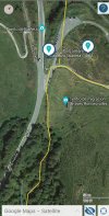
I walked down the NA-2033 until the church, then there is a mostly flat trail to the left that goes through the woods parallel to the road.

You can see it in this picture.

Screenshot_20240115_083245_Buen Camino.jpg
 
I didn't consider the NA-135 as being the "long walk right next to the road down into Roncevalles" because a yellow arrow near the chapel steers peregrinos to the trail paralleling that highway (that trail marked in camino yellow at the bottom of your picture). I thought the "long road" was the steeper NA-2033 coming down from Lepoeder.
1000005797-01.jpeg
 
Last edited:
I'm sorry, I missed the "further on" part of your request. So, I'm taking that as meaning "after walking along the paved road downhill for awhile." There doesn't appear to be a trail going down between the two already discussed. I looked at an Open Street Map map of the Roncesvalles area showing trails and I only see two ways to Roncesvalles from the Col de Lepoeder.

Hmm, okay, something to ponder there... might be a wait and see approach dependent on weather. Thank you.
I didn't consider the NA-135 as being the "long walk right next to the road down into Roncevalles" because a yellow arrow near the chapel steers peregrinos to the trail paralleling that highway (that trail marked in camino yellow at the bottom of your picture). I thought the "long road" was the steeper NA-2033 coming down from Lepoeder.
View attachment 162178
The pic's helpful - I don't recall seeing this, perhaps we were too busy engaging in chatting with our new fellow pilgrim friends?! Nothing like hindsight and experience for future reference. Thank you.
 
Get a spanish phone number with Airalo. eSim, so no physical SIM card. Easy to use app to add more funds if needed.
Yes, this must be what happened, perhaps it was an unconscious choice as we were walking with another pilgrim who had walked before and followed his lead. Well, it's good to know there's a choice and we'll look at that more closely when time comes. Thanks, @trecile!
 
Definitely like the pic
Past the Bird info centre which looks like it could be a refuge & very much worth going into if open ;
then to the fence in the meadow & through the wooden gate. It’s lovely & not a narrow path.
 
Join our full-service guided tour and let us convert you into a Pampered Pilgrim!
My question is; having taken the path to the right at Col le Lepoeder, is there another option further on that can be taken to eliminate quite a long walk right next to the road down into Roncevalles?

Short answer: YES OUI SÍ

Long answer:
I arrived at Saint-Jean on 30 April and, amongst other things, consulted the Pilgrim's Office for the Friends of Saint James on all sorts of things. Looking back, I very clearly recall being told two things:
1) along the tops were many upstanding poles, each have a directing arrow and a sequential number. And that, at pole numbered such and such (76?) I should turn right and not follow the poles any further.
2) the path was open, but there was a little snow in the pass.

Come 1 May, I was euphoric. I had left Le Puy just on 3 week before and was now ready for anything.
Just before Orisson I entered cloud, but no wind.
At the last stamp caravan, I paused, saw the figurative 5,000 trying to feed themselves and continued on.
At the Col there was a small service team guiding all comers through the last bit of snow.
I had noticed the poles, wondered why they were numbered but did not remember the advice so earnestly given the day before..
As I came down the road I could see it taking a steep u turn to the right while the poles, lake sirens, lured me on. And I felt in good company. There were four others wondering whether to plow on or take the road.

For me the trip down the steep path through the forest was brilliant. I was now in sunshine and had some views of the forested slopes on the other side of the valley.

And I arrived at the Roncesvalles albergue around 13h, having left Saint-Jean about 07h30.

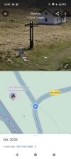
When I was home, I followed the road (NA2033) down the hill with street level imagery.
And quietly rejoiced I had not followed it.
With the twists and turns and falls away on the left side, I would have had a time consuming task of either walking facing any oncoming traffic or being on the outside of bends and trying not to look at the slope beside the road.

Kia kaha (take care, be strong)
 
When I was home, I followed the road (NA2033) down the hill with street level imagery.
And quietly rejoiced I had not followed it.
With the twists and turns and falls away on the left side, I would have had a time consuming task of either walking facing any oncoming traffic or being on the outside of bends and trying not to look at the slope beside the road.
The only traffic that I have encountered was a herd of sheep.
 
Join our full-service guided tour of the Basque Country and let us pamper you!
Short answer: YES OUI SÍ

Long answer:
I arrived at Saint-Jean on 30 April and, amongst other things, consulted the Pilgrim's Office for the Friends of Saint James on all sorts of things. Looking back, I very clearly recall being told two things:
1) along the tops were many upstanding poles, each have a directing arrow and a sequential number. And that, at pole numbered such and such (76?) I should turn right and not follow the poles any further.
2) the path was open, but there was a little snow in the pass.

Come 1 May, I was euphoric. I had left Le Puy just on 3 week before and was now ready for anything.
Just before Orisson I entered cloud, but no wind.
At the last stamp caravan, I paused, saw the figurative 5,000 trying to feed themselves and continued on.
At the Col there was a small service team guiding all comers through the last bit of snow.
I had noticed the poles, wondered why they were numbered but did not remember the advice so earnestly given the day before..
As I came down the road I could see it taking a steep u turn to the right while the poles, lake sirens, lured me on. And I felt in good company. There were four others wondering whether to plow on or take the road.

For me the trip down the steep path through the forest was brilliant. I was now in sunshine and had some views of the forested slopes on the other side of the valley.

And I arrived at the Roncesvalles albergue around 13h, having left Saint-Jean about 07h30.

When I was home, I followed the road (NA2033) down the hill with street level imagery.
And quietly rejoiced I had not followed it.
With the twists and turns and falls away on the left side, I would have had a time consuming task of either walking facing any oncoming traffic or being on the outside of bends and trying not to look at the slope beside the road.

Kia kaha (take care, be strong)
Very descriptive and as curiosity would have it, I’ll make a point of asking about the numbered poles when on SJPDP in April. I’ve not seen or heard of these previously.
 
Very descriptive and as curiosity would have it, I’ll make a point of asking about the numbered poles when on SJPDP in April. I’ve not seen or heard of these previously.
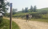
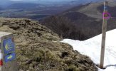
@AussieSunnygirl, and yet you must have walked past these numbered poles, all 82 of them 😊. They have been installed so that pilgrims can indicate their position to the firebrigade's team when they phone for help and need rescuing. Below is a photo of pole #53.

I am a bit puzzled by the advice given in post #17. A "trip down the steep path through the forest" and not following the road (NA-2033)? That is one of the two options that one can take right after the Lepoeder pass, and from all I have heard and read it is the option that the Pilgrim Office's volunteers strongly advise against because it is apparently more accident-prone than the other option along road NA-2033 that leads to the chapel of Ibañeta.

Screenshot 2024-01-24 at 07.09.jpg
 
Last edited:
Join our full-service guided tour and let us convert you into a Pampered Pilgrim!
And here is pole #75 on the short and steep shortcut just between the Lepoeder pass and the road NA-2033. Here you are advised by the Pilgrim Office to turn right into this road. But this is not the location where the OP lost the Camino trail, which happened much further down this road near the modern chapel.

There is next to no oncoming traffic on road NA-2033. It is a service road that is used by the fire brigade for their pilgrim rescue missions.

PS: Note the emergency phone number 112 stamped onto the pole.
Pole 75.jpg
 
Last edited:
Well, I am a little confused now. However, I feel from studying the map provided by @trecile that I understand where we went last Camino, and also the alternative route to which I am looking for and which I refer to in my original post. I think perhaps some responders may have mistakenly thought I was in some way querying which direction to take, left or right, at Col le Lepoeder, however, it was further on that I was interested in.
Referring to @trecile's image, the N-135 is the road I was referring to as being the concern for me - certainly not a service road (N-2033), but a bitumen road carrying a fair amount of vehicular traffic and as I mentioned, no other pilgrims that I saw.
I guess I could be forgiven for not taking the numbered posts into account as I've never heard of them either then or since, even from the the Pilgrim's Office in SJPDP to refer to them should I be in need of rescuing - thankfully, that wasn't the case. Having said this, I don't know if they would've made a difference to which route/s one should take?
Like many things on the Camino and in life generally speaking, there seems be a difference of opinion as to which is the best route to take. It doesn't appear that there's a right or wrong, just a choice - hopefully a safe choice, which was what I was interested in. Thank you to everyone who has contributed to wanting to help me with my query.
 
Having said this, I don't know if they would've made a difference to which route/s one should take?
No, these numbered poles would not have made any difference. I merely posted photos of them in order to help understand what the various posters are talking about - it can get confusing when one describes something only in words and relies on one's memory. I did happen to notice them when I walked but only because I had read about them beforehand in the context of rescue operations. I would probably not have noticed them otherwise because there is so much else to look at.
 
€2,-/day will present your project to thousands of visitors each day. All interested in the Camino de Santiago.
The Pilgrim Office in SJPP hands out a leaflet with a kind of hand-drawn map and numerous photos explaining their recommended Camino trails from SJPP to Roncesvalles. They have a copyright on it and don't publish it on the web unfortunately. I tried to find a reproduction online but without success so I don't know whether the spot near the Ibañeta chapel is addressed.

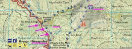
There is a leaflet with a free topographical map produced by the Spanish geographical office IGN but it is unfortunately not widely known. It clearly shows the path parallel to the road N-135 (in red) and how this path goes first through meadows and then through the forested area close to Roncesvalles. Below is an extract of this official map where purple arrows point to the path being discussed in this thread. It is just another version of the map/satellite view in post #10.

BTW, the orange warning sign with an exclamation mark means: "Peligro: caidas" - "Hazard: Danger of slipping/falling".

SOS Map.jpg

Source: https://www.caminosantiago.org/cpperegrino/servicios/pdf/MapaSosPirineos.pdf
 
Last edited:
The Pilgrim Office in SJPP hands out a leaflet with a kind of hand-drawn map and numerous photos explaining their recommended Camino trails from SJPP to Roncesvalles. They have a copyright on it and don't publish it on the web unfortunately. I tried to find a reproduction online but without success so I don't know whether the spot near the Ibañeta chapel is addressed.
I had once made a post with a link to the PDF with that map but got a 404 error when I tried the link. I figured it was renamed or moved so I tried a Google search for
cize site:xacobeo.fr

I was able to see the map in the results but I got another 404 error with a link attempt. Unsuccessfully trying a few other tricks I found that xacobeo.fr itself was not found so maybe try again some other time. The URL that Google gave was:


Wait, I found a copy of the map here on the forum:
 
Last edited:
Down bag (90/10 duvet) of 700 fills with 180 g (6.34 ounces) of filling. Mummy-shaped structure, ideal when you are looking for lightness with great heating performance.

€149,-
The Pilgrim Office in SJPP hands out a leaflet with a kind of hand-drawn map and numerous photos explaining their recommended Camino trails from SJPP to Roncesvalles. They have a copyright on it and don't publish it on the web unfortunately. I tried to find a reproduction online but without success so I don't know whether the spot near the Ibañeta chapel is addressed.

There is a leaflet with a free topographical map produced by the Spanish geographical office IGN but it is unfortunately not widely known. It clearly shows the path parallel to the road N-135 (in red) and how this path goes first through meadows and then through the forested area close to Roncesvalles. Below is an extract of this official map where purple arrows point to the path being discussed in this thread. It is just another version of the map/satellite view in post #10.

BTW, the orange warning sign with an exclamation mark means: "Peligro: caidas" - "Hazard: Danger of slipping/falling".

View attachment 162613

Source: https://www.caminosantiago.org/cpperegrino/servicios/pdf/MapaSosPirineos.pdf
@Kathar1na thank you, the map also confirms the image posted by Trecile as you note, but with a greater degree of perspective. I have a much clearer idea now of where to turn off once we reach the bottom of the NA 2033. It's clear to see that the path does mirror the N-135, and with only foot traffic, much more safe! I'm sure I'll have a bit of a giggle to myself when I come across the numbered poles. (Might even take a pic for posterity) Many thanks, again for your input.
 
I had once made a post with a link to the PDF with that map but got a 404 error when I tried the link. I figured it was renamed or moved so I tried a Google search for
cize site:xacobeo.fr

I was able to see the map in the results but I got another 404 error with a link attempt. Unsuccessfully trying a few other tricks I found that xacobeo.fr itself was not found so maybe try again some other time. The URL that Google gave was:


Wait, I found a copy of the map here on the forum:
You went to so much trouble @Rick of Rick and Peg! That's very kind of you. Thank you, I'll take a look... insert smiley emoji
 

Most read last week in this forum

Just an FYI that all available beds are taken in SJPDP tonight - fully, truly COMPLETO! There’s an indication of how busy this year may be since it’s just a Wednesday in late April, not usually...
Between Villafranca Montes de Oca and San Juan de Ortega there was a great resting place with benches, totem poles andvarious wooden art. A place of good vibes. It is now completely demolished...
Hi there - we are two 'older' women from Australia who will be walking the Camino in September and October 2025 - we are tempted by the companies that pre book accomodation and bag transfers but...
We have been travelling from Australia via Dubai and have been caught in the kaos in Dubai airport for over 3 days. Sleeping on the floor of the airport and finally Emerites put us up in...
Hi all, Very new to this so please excuse any ignorance or silly questions :) I'm walking my very first Camino in 2 weeks (iieeeek) - the countdown is on and excitement through the roof. I've...
From a friend on the ground in Pamplona https://www.noticiasdenavarra.com/fotos/general/sociedad/2024/04/23/nieve-primaveral-presente-navarra-8152386.html

❓How to ask a question

How to post a new question on the Camino Forum.

Forum Rules

Forum Rules

Camino Updates on YouTube

Camino Conversations

Most downloaded Resources

This site is run by Ivar at

in Santiago de Compostela.
This site participates in the Amazon Affiliate program, designed to provide a means for Ivar to earn fees by linking to Amazon
Official Camino Passport (Credential) | 2024 Camino Guides
Back
Top