• For 2024 Pilgrims: €50,- donation = 1 year with no ads on the forum + 90% off any 2024 Guide. More here.
    (Discount code sent to you by Private Message after your donation)

Search 69,459 Camino Questions

GPX File Question

GuyA

Active Member
Time of past OR future Camino
2023
In 2022…after receiving great help on the Forum…I downloaded GPX files from the Wikiloc database and walked the Camino Primitivo and Camino San Salvador routes. Wikiloc was most helpful!

In a month I will walk the 700 km Island Walk in PEI Canada. I was provided the attached GPX file.

I admit to being quite baffled as to whether the tracks in this file can be utilized by the Wikiloc app. I could not open it with my iPhone…Retrace I think is Android compatible.

Any words of wisdom are appreciated 😊quite out of my depth…once again 😂

Guy
 

Attachments

  • Retrace_2023-03-11_2025.gpx
    377.7 KB · Views: 19
St James' Way - Self-guided 4-7 day Walking Packages, Reading to Southampton, 110 kms
I have limited understanding of these things, but perhaps my simplistic explanations will be helpful. If I have oversimplified for mis-stated anything, I hope the more knowledgeable readers will correct me.

Wikiloc is an excellent source for GPS files and KML files (the two file types that are used on most mapping apps). Wikiloc is also an app that allows you to record your walking, and follow a track that has been uploaded to its database. You have a GPX file, which might not be in the Wikiloc collection (if nobody has uploaded it there.) I don't know their process for uploading files.

I use Wikiloc as a catalog/source to find files that I then download to use on another app. They are available as either GPX files or KML files, and which one you need depends on which program you will use it on. I use KML files and put them on Organic Maps (or maps.me in the past).

If your track is not on Wikiloc (and I don't see one there) then you cannot follow it on Wikiloc. Instead you need another mapping program that reads GPS files. Or you need to get a KML file from wherever you got your GPX file, and use a program such as Organic Maps that handles that type of file.
 
I had a bit of a problem getting Wikiloc to work with the file but I downloaded to my Android phone and then using a file manager long pressed it to get a menu of what to do I said to open it and then to use OSMand to do the deed. This is all file manager stuff and so things might not be the same for you. The trail was shown (it's about 700 km long) but only on an extremely basic map of PEI. I was prompted to download a detailed map of the island, I didn't as at this point I was really testing if the GPX file was corrupt. It looks OK. I then asked to open it in Wikiloc and I got a preview. Clicking the map part of the preview it wanted either a downloaded map or one from an internet connection. I said okay for the internet using an Open Street Map map. Clicking the map again I got the track and a detailed underlaying map. I did NOT get a prompt asking if I wanted to follow it though. That may be because I am nowhere near Canada at the moment.

So, it looks like you can get Wikiloc to display a map and the track and probably show you where on the track you are at. Unknown is whether you can FOLLOW the track, that is to say, just walk and have it notify you if you have gone off track.

The solution may be to upload the borrowed track to your Wikiloc account as if it were your own and then use the Wikiloc app to grab it from your track list.
 
Down bag (90/10 duvet) of 700 fills with 180 g (6.34 ounces) of filling. Mummy-shaped structure, ideal when you are looking for lightness with great heating performance.

€149,-
In 2022…after receiving great help on the Forum…I downloaded GPX files from the Wikiloc database and walked the Camino Primitivo and Camino San Salvador routes. Wikiloc was most helpful!

In a month I will walk the 700 km Island Walk in PEI Canada. I was provided the attached GPX file.

I admit to being quite baffled as to whether the tracks in this file can be utilized by the Wikiloc app. I could not open it with my iPhone…Retrace I think is Android compatible.

Any words of wisdom are appreciated 😊quite out of my depth…once again 😂

Guy
You should be able to upload ut to Wikiloc via web interface and then select it as offline.


You can also use software like GPX Viewer (my favourite) to view GPX files stored on your phone (iOS).
 
In 2022…after receiving great help on the Forum…I downloaded GPX files from the Wikiloc database and walked the Camino Primitivo and Camino San Salvador routes. Wikiloc was most helpful!

In a month I will walk the 700 km Island Walk in PEI Canada. I was provided the attached GPX file.

I admit to being quite baffled as to whether the tracks in this file can be utilized by the Wikiloc app. I could not open it with my iPhone…Retrace I think is Android compatible.

Any words of wisdom are appreciated 😊quite out of my depth…once again 😂

Guy

1. Not sure this answers your question, GuyA, but I downloaded it onto my Android phone and told the download window to open the file in OsmAnd+ (which is what I happen to use for mapping and navigation). The file instantly displayed in OsmAnd+ as a normal track file which can be tailored for colour, route direction arrows activated, file renamed, etc.

2. (Later) After I installed the Wikiloc app on the Android phone, and joined Wikiloc, I then downloaded the file again and told the download window to open it in Wikiloc. It worked instantly.

Wishing you an excellent trip around PEI.
 
Last edited:
Wow I thank everyone for really going the distance to help me out. Over the next couple of days I will try these various suggestions and hopefully report back with a success!

Much appreciated! I am told that it’s very difficult to get lost on the Island Walk however I know better…or at least I know myself 😂.

I understand every 5 kms or so there is a sign…but from my past walks 5 kms is an hours time and well the mind wanders and then I wonder about that side road back there etc. Saving grace for me is this walk is in Canada 🇨🇦…never would have expected a long walk here!

Merci

Guy
 
Very light, comfortable and compressible poncho. Specially designed for protection against water for any activity.

Our Atmospheric H30 poncho offers lightness and waterproofness. Easily compressible and made with our Waterproof fabric, its heat-sealed interior seams guarantee its waterproofness. Includes carrying bag.

€60,-
In 2022…after receiving great help on the Forum…I downloaded GPX files from the Wikiloc database and walked the Camino Primitivo and Camino San Salvador routes. Wikiloc was most helpful!

In a month I will walk the 700 km Island Walk in PEI Canada. I was provided the attached GPX file.

I admit to being quite baffled as to whether the tracks in this file can be utilized by the Wikiloc app. I could not open it with my iPhone…Retrace I think is Android compatible.

Any words of wisdom are appreciated 😊quite out of my depth…once again 😂

Guy
If like to know about your planned accommodations on the PEI Island Walk. My first casual glance at the route showed only B&B type places and prices. Too expensive for 700 km of lodging. What's your plan?
 
If like to know about your planned accommodations on the PEI Island Walk. My first casual glance at the route showed only B&B type places and prices. Too expensive for 700 km of lodging. What's your plan?
Charlie you are absolutely correct that lodging is quite expensive and not always available at stage end points. I learned that early on as well as the need for multiple shuttles. B&B, Inns etc similar to when I walked in the UK along the river Thames.

I thought long and hard about this…in the end at 66 years young decided “go for it”…a long walk in Canada. I have a 24 day walk planned instead of the 32 stage’s recommended.

My latest light hearted blog post will provide some info on the walk…it refers to an earlier post as well describing the walk.

http://caminolongwalk.blogspot.com/2023/03/island-walk-prince-edward-island-just.html?m=1

I will be blogging daily during my walk…at least that’s the plan…if interested just subscribe at the bottom of the web version of the blog and emails are sent as blogs are made. I expect over time accommodation choices will increase but I don’t have the luxury of waiting it out.

Will I be successful…hope so…if not I tried 😊

Guy
 
The 9th edition the Lightfoot Guide will let you complete the journey your way.
Charlie you are absolutely correct that lodging is quite expensive and not always available at stage end points. I learned that early on as well as the need for multiple shuttles. B&B, Inns etc similar to when I walked in the UK along the river Thames.
I'll make a note of following along. I had looked at doing the western portion of the island last year with my sister but decided against it because of the daily need for taxis back and forth to accommodations. We thought it was a logical nightmare, I hope your experience proves me wrong! I'm surprisingly back on the island this June for a holiday after 30 years away.

My cousin has a restaurant at Stanley Bridge Country Resort and a food truck in Summerside (I think it's in Summerside, the truck may not be open until mid June though) if you like BBQ or seafood. :D There's also a cute little restaurant in North Lake (near East Point) that made the best lobster roll and cinnamon rolls (warmed up!!) that were just like my mother's. There's a little bakery in Kensington that makes a lot of "old fashioned" goods, try the "hard biscuits/pastry biscuits" if they're available.
 
In 2022…after receiving great help on the Forum…I downloaded GPX files from the Wikiloc database and walked the Camino Primitivo and Camino San Salvador routes. Wikiloc was most helpful!

In a month I will walk the 700 km Island Walk in PEI Canada. I was provided the attached GPX file.

I admit to being quite baffled as to whether the tracks in this file can be utilized by the Wikiloc app. I could not open it with my iPhone…Retrace I think is Android compatible.

Any words of wisdom are appreciated 😊quite out of my depth…once again 😂

Guy
Just copy the file & upload it into MAPS.ME
 
I'll make a note of following along. I had looked at doing the western portion of the island last year with my sister but decided against it because of the daily need for taxis back and forth to accommodations. We thought it was a logical nightmare, I hope your experience proves me wrong! I'm surprisingly back on the island this June for a holiday after 30 years away.

My cousin has a restaurant at Stanley Bridge Country Resort and a food truck in Summerside (I think it's in Summerside, the truck may not be open until mid June though) if you like BBQ or seafood. :D There's also a cute little restaurant in North Lake (near East Point) that made the best lobster roll and cinnamon rolls (warmed up!!) that were just like my mother's. There's a little bakery in Kensington that makes a lot of "old fashioned" goods, try the "hard biscuits/pastry biscuits" if they're available.
Ok that will be my experience as well here is a summary of planned shuttle rides from my blog. Note though I have deviated from the 32 stages. The shuttle rides are planned to ensure I walk the entire route.

A friend of mine has stated this is the Camino de la Shuttle. If I was wasn’t walking solo the costs while certainly higher than a typical Camino would seem closer to expected…oh well…I am looking forward to visiting this beautiful island and eating food as you describe 😊 It’s an adventure I tell various folks!

« Shuttle rides at either beginning or end points for daily walk

- 10 walking days with no required shuttle rides...walk out the door am...arrive at new door pm 😀
- 11 walking days with 1 required shuttle ride...either am or pm...backwards or forward 🙃
- 3 walking days with 2 required shuttle rides...both am and pm...really strange 🤪

In total 17 shuttle rides over the 24 days...now what could go possibly wrong? 🤣 Will I be sleeping on a park bench, in the forest or on a beach somewhere due to a shuttle snafu...time will tell! »
 
Join our full-service guided tour of the Basque Country and let us pamper you!
Many suggestions for the GPX question asked and I appreciate them all. Over the next while will try them one by one. They all sound so easy when you know what you are doing…I am sure/hoping one of the ideas will do click with my non GPX brain!

Many thanks

Guy
 
Just copy the file & upload it into MAPS.ME
Currently Maps.me and some other apps do not support files in the .gpx format; they only support files in the .kml or .kmz formats. That's why Elle's comment (copied below) is useful.
You can easily convert a GPX file to KML at this website: https://gpx2kml.com/


And you should be able to upload either GPX or KML to Wikiloc and use it without a problem.
Yes, you can upload in any fashion and if the file is made public it can be downloaded by any Wikiloc member in either format with Wikiloc doing the conversion.
 
Guy, let me add a few comments about your 700 km track.

One downside to such a long track is that while you are hot and tired and wondering how much further you have to walk for the day you will look at the app and say "Great, only 588 kms to go." You may prefer using a track editor to break up the long stretch in daily stages.

Another situation is likely to come up using Wikiloc on such a long track. Halfway through the 700 km hike whenever you start Wikiloc for the day and walk it will likely tell you that you are headed in the wrong direction. Keep going, it will eventually decide you know what you are doing. At least I found something similar three years ago. Apparently when you start at some mid-point in the track it assumes you want to walk in the direction of the longest point in the hike. I wrote about this in a previous post at the top of this thread.

 
Join our full-service guided tour and let us convert you into a Pampered Pilgrim!
Also, Guy, you may not need Wikiloc to notify you that you have walked off the trail. We already have checked that OSMand can read the track and there is a little known feature in the app that can given you spoken directions to follow a track, much like Google Maps does when you are driving. The expert would be @woody66. I mentioned the feature to him some time ago and he has used it on his camino(s). I once did a quick test in my neighborhood, recording a short track and then following it again with voice directions. It did the job. I can't remember how I set it up though.
 
Ok that will be my experience as well here is a summary of planned shuttle rides from my blog. Note though I have deviated from the 32 stages. The shuttle rides are planned to ensure I walk the entire route.

A friend of mine has stated this is the Camino de la Shuttle.
LOL!

It's a beautiful island and everyone is very nice and there is great food to be had. Make sure you have warm clothes as it can get very chilly before July. North East of Souris is a park called Basin Head, if it's not out of your way take a barefoot stroll along the beach to listen to the Singing Sands (scuff your feet hard as you step to make the sand sing) Oh! Keep an eye out for foxes! The island used to be a major fox fur producer and many foxes were let loose during the Great Depression as they couldn't afford to feed them anymore and there are no real predators for them.

Singing Sands
Buen Camino!
 
You can easily convert a GPX file to KML at this website: https://gpx2kml.com/ And you should be able to upload either GPX or KML to Wikiloc and use it without a problem.
Brilliant…success I think…downloaded as suggested…then on Wikiloc.com…pulled in file in 4 easy steps…added a PEI map and voila I think 🤔…available on my Wikiloc App.

Can it really be that simple…must be missing something 😊

The highest elevation point in the PEI Island Walk is 91m…yikes 😂…ok so very flat…but I have 7 days just over 40 kms 😱.

What an adventure this promises to be…

Many thanks 🙏 to all for your help once again with my GPX for Dummies questions.

Assuming I have properly loaded the Island Walk track I will upload my daily walks to Wikilocs so that others can see more manageable chunks.

4 weeks to go!

Guy
 

Attachments

  • IMG_1920.png
    IMG_1920.png
    1.2 MB · Views: 1
The 9th edition the Lightfoot Guide will let you complete the journey your way.
Brilliant…success I think…downloaded as suggested…then on Wikiloc.com…pulled in file in 4 easy steps…added a PEI map and voila I think 🤔…available on my Wikiloc App.

Can it really be that simple…must be missing something 😊
Yes, it really is that simple. I upload GPX tracks to Wikiloc frequently and have never had a problem. Just be sure that you have clicked on the button at the bottom of the newly uploaded track that says “available offline”. The button needs to be showing green in order for you to follow the track without cell or WiFi.

Hurray for sharing daily tracks! Others will be grateful.

I’ll be following along, Guy!
Elaine
 
Last edited:
Guy, let me add a few comments about your 700 km track.

One downside to such a long track is that while you are hot and tired and wondering how much further you have to walk for the day you will look at the app and say "Great, only 588 kms to go." You may prefer using a track editor to break up the long stretch in daily stages.

Another situation is likely to come up using Wikiloc on such a long track. Halfway through the 700 km hike whenever you start Wikiloc for the day and walk it will likely tell you that you are headed in the wrong direction. Keep going, it will eventually decide you know what you are doing. At least I found something similar three years ago. Apparently when you start at some mid-point in the track it assumes you want to walk in the direction of the longest point in the hike. I wrote about this in a previous post at the top of this thread.

Hi...this is quite funny...at least to me. I am looking at a track from Forwalk from Lucca to Rome on the Via Francigena...you know just for fun ☺️
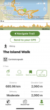
. No problem I download the GPX file into Wikilocs. I now have a file with 415 kms over 15 stages with total elevation gains 7,325m and losses (7,312)m.

What I would like to do is obtain the elevation gains and losses by stage...Forwalk gives me the kms walked by stage. The reason I do this is I have found that Total Elevation Gains/Losses per Km of walking is a very good indicator of how challenging a day will be. So I googled “how do I break up a Wikiloc file into stages?” AND voila I readily find this Camino Forum discussion which I started 🤣.

You mention using a “track editor” to break up the long stretch in daily stages. I would appreciate knowing what app you would recommend to do this. Sounds like fun to me 🤓.

Guy
 
You mention using a “track editor” to break up the long stretch in daily stages. I would appreciate knowing what app you would recommend to do this. Sounds like fun to me 🤓.
GPX is a text file using an XML format.

Any good text editor will handle the file. An editor like droidedit on an Android phone or notepad++ on a PC works for me.

A bit of nous helps when you come to break it into smaller stages but if you are willing to learn then you will master it.
 
St James' Way - Self-guided 4-7 day Walking Packages, Reading to Southampton, 110 kms
Guy, I don't know any track editors so I can't recommend any. I've done what @DoughnutANZ says, I've used a text editor. They will work for files in the gpx format and also for kml ones. They can't be used directly for files in the kmz format (there are ways but you need experience with the kml files first).

It really isn't difficult. Do this: copy full_original.gpx to test.txt and then view that or get into it with a text editor. You'll see that you can remove lines that aren't part of the partial track you want to create. Remove those lines and the waypoints that are outside the area you are interested in. Save the resulting file, exit and rename test.txt to test.gpx and run that though the tools you have and know to check things out.

You can also join multiple files to produce a single track.

I'm sure there are tools that you can find to do the job easier but I've gotten so used to doing things this way I've not bothered to seek them out.
Thanks Rick and @DoughnutANZ for your quick and helpful replies. I just googled « text editor » and there are multiple apps for IOS so will play with these.

Sounds from what both of you have said it’s kind of brute force editing once I have the GPX file in the text editor software…totally fine with that. I have time to do this kind of stuff 😊
 
@GuyA, I've been happy with using GPX Editor, but it is for a Mac. And GPX Studio is great. You can split a track easily and visually by following their directions:
Directions from their user manual: There are two options for splitting tracks:
  1. Use the slider in the bottom panel to move the start and end points of the trace. Click on the check box to validate the selection. Check the box. Keep cropped parts in new files and then click on Proceed.
  2. Enter the edition mode by clicking on the pencil. Then, click on an anchor point or on the line and use the scissors symbol "Split here" to split the trace at a chosen location.
The second option would probably work well for what you want to do. Upload the long track into the editor; click on the pencil; click on the track at each point where you want to split it; and then save all the new, shorter tracks.
 
Last edited:
3rd Edition. More content, training & pack guides avoid common mistakes, bed bugs etc
@GuyA, I've been happy with using GPX Editor, but it is for a Mac. And GPX Studio is great. You can split a track easily and visually by following their directions:
Directions from their user manual: There are two options for splitting tracks:
  1. Use the slider in the bottom panel to move the start and end points of the trace. Click on the check box to validate the selection. Check the box. Keep cropped parts in new files and then click on Proceed.
  2. Enter the edition mode by clicking on the pencil. Then, click on an anchor point or on the line and use the scissors symbol "Split here" to split the trace at a chosen location.
The second option would probably work well for what you want to do. Upload the long track into the editor; click on the pencil; click on the track at each point where you want to split it; and then save all the new, shorter tracks.
@islandwalker Elaine - Brilliant! Similar to you helping me navigate Wikilocs you have done it again! I have as yet not tried to split the GPX file however my initial question about Elevation Gains/Losses by stage is now answered. Super easy ...Load the GPX file saved on the Mac and then click on the icon which provides segments/tracks at the bottom. Then just click on individual tracks and voila everything I am looking for is there.

GPX Studio is a really neat tool...oh my how many fun hours lie ahead!

Thanks Guy
 
GPX Studio is a really neat tool...oh my how many fun hours lie ahead!
That's exactly what I thought when I first discovered it. It's good you have a Mac to do this on, because it is finicky on a phone. If it ends up not working properly for you, Gaia GPS also allows you to snip the ends of a track and save the new track. I love Gaia for another reason: it lets me put all my routes for a given area on one map (in different colors) and then compare them.

As an aside, I am so grateful to the people on this forum who answer GPX questions. In fact, my very first question on the forum, 11 years ago, was how to get a gpx track onto an iPad. Since then, I've gotten a lot of help from all the other people making suggestions above and also from @BlackRocker57.

Good luck, Guy. Let us know if it works!
 

Most read last week in this forum

Hey all. I haven't been on the forum for quite sometime (years probably). I walked the Camino Frances in 2016 and to say it was life changing for me is an understatement. On day 3, at the café at...
When you stop at a bar for a beer, wine, coffee or bite to eat, and sit at a table, is it expected that you will return your dirty dishes up to the bar before you leave? I alway do, as it seems...
Everyone talks about the wonderful café con leche, but what if tea is more to your liking? Can you even get tea along the Camino (Frances)? I don’t drink coffee but my morning cup of tea is...
I am just back from a few weeks on the Via the la Plata. Since 2015 I have been nearly every year in Spain walking caminoroutes I loved the café con leches. This year I did not like them as much...
Let me preface this by saying please understand I am not picking on anybody, I fully understand that mistakes happen and how. Been there, done that. I have been astonished to see so many lost...
A promotion started here right now. A step-counting sweater from Wolkswagen records how far you walk, and if you walk 613 km (which is the range of the latest model) before 16th June, you can win...

❓How to ask a question

How to post a new question on the Camino Forum.

Similar threads

Forum Rules

Forum Rules

Camino Updates on YouTube

Camino Conversations

Most downloaded Resources

This site is run by Ivar at

in Santiago de Compostela.
This site participates in the Amazon Affiliate program, designed to provide a means for Ivar to earn fees by linking to Amazon
Official Camino Passport (Credential) | 2024 Camino Guides
Back
Top