• For 2024 Pilgrims: €50,- donation = 1 year with no ads on the forum + 90% off any 2024 Guide. More here.
    (Discount code sent to you by Private Message after your donation)

Search 69,459 Camino Questions

Roads versus Trails

KevinWilcox

Member
Time of past OR future Camino
April 2025
Dumb as it might seem, it's only recently sunk in that a good deal of some camino routes might be on vehicular roads rather than walking trails. I don't really mean the town and village-y bit, that's fairly self-evident, more the stretches in between. I think my understanding may have been incorrectly influenced by the various youtube videos I watched when I first started my prep a few weeks ago, all of which seemed to be on dirt track and trails.

Am I right? And if so, what routes have the least / quietest / most pleasant road walking?
 
Ideal pocket guides for during & after your Camino. Each weighs only 1.4 oz (40g)!
Hi! First of all, which camino do you mean?
Most routes from the middle ages were replaced by roads or even motorways.
The path to Santiago is very varied. You take it for what is 😉
 
Hi, I mean any of the routes that get discussed a lot on here. Broadly, Spain, Portugal. I really do get the 'sweet and sour' argument, believe me I've done my share of that, but with this question I'm looking to understand which caminos have the highest ratio of trail-walking, that's all. Any additional detail i.e. "the 7 days from X to Y on Camino de ???? are almost entirely tarmac" would be great, but general pointers would also be helpful.
 
Ideal pocket guides for during & after your Camino. Each weighs only 1.4 oz (40g)!
I understand what you mean now, I will let other people answer because I don’t have a clue! I think, from memory, the Aragones was the best…ie most ‘trail’ walking?
 
The 40 days or so on the Norte are mostly on asphalt or cement. Pick any individual section and it’s the same. Take the coastal/country variants…and it’s the same!

The Aragon is mostly trail.
 
I think it's qualifies as a trail if its accessible by foot, including animals. Once a wheel is on it, it becomes a road. But seemingly in Spain they found the optimal routing in the landscape. Whereupon the Romans metallised and straightened them out.

On a road I can look about and in the distance. On a trail it's head down watching for trips and slips.

I think a lot of modern trails are created to avoid private land and motorways.

On sections of the VDLP crossing farmlands I found alternative farm tracks to avoid the flooded trail. It was the same underfoot but on higher ground. Eventually walking most of it by road.

Feb/March had unpleasant conditions and I needed to stay clean and dry. Thus avoiding doing laundry in the albergue. Only to find restaurant and shop closed.
 
Down bag (90/10 duvet) of 700 fills with 180 g (6.34 ounces) of filling. Mummy-shaped structure, ideal when you are looking for lightness with great heating performance.

€149,-
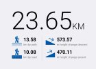
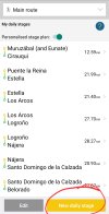
The Buen Camino app shows how many kms if each stage are on paved roads and how many are on trails. You can see this on each stage like this:

Screenshot_20240510_092538_Buen Camino.jpg

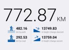
I also created a "stage" that covers the entire Camino Francés. It shows 292.53 km that is paved and 482.16 km that's trails

Screenshot_20240510_092602_Buen Camino.jpg

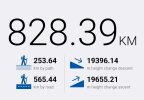
I did the same thing for the Norte

Screenshot_20240510_092429_Buen Camino.jpg

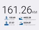
And here's the Aragonés

Screenshot_20240510_092859_Buen Camino.jpg
 
I think, from memory, the Aragones was the best…ie most ‘trail’ walking?
The Aragon is mostly trail.
The Buen Camino app shows how many kms if each stage are on paved roads

Thank you, all. That's exactly what I was asking for and really helpful. The question arose because I was starting to look at the Camino Norte, having done some very enjoyable mountain walking in the Picos de Europa a while back, but on looking at it on google maps in more detail, I got the sense that the Norte is mostly paved. That might still be very nice walking but I wanted to understand this in advance rather than turn up with a whole bunch of misconceptions. That said, despite the horror stories about over-crowding that I've been seeing on here for the last two or three weeks, the Frances is starting to appeal again. Either way, I at least now know where to look.
 
The Buen Camino app shows how many kms if each stage are on paved roads and how many are on trails. You can see this on each stage like this:

View attachment 169925

I also created a "stage" that covers the entire Camino Francés. It shows 292.53 km that is paved and 482.16 km that's trails

View attachment 169927

I did the same thing for the Norte

View attachment 169928

And here's the Aragonés

View attachment 169929
Trecile, is the Norte stage you created just the official way, or is it including the oft discussed coastal variants?

I have to say either way: whilst I knew the Norte theoretically included a significant amount of road walking I hadn't realized how high the percentage actually is.
 
Get a spanish phone number with Airalo. eSim, so no physical SIM card. Easy to use app to add more funds if needed.
The Buen Camino app shows how many kms if each stage are on paved roads and how many are on trails. You can see this on each stage like this:

View attachment 169925

I also created a "stage" that covers the entire Camino Francés. It shows 292.53 km that is paved and 482.16 km that's trails

View attachment 169927

I did the same thing for the Norte

View attachment 169928

And here's the Aragonés

View attachment 169929
Out of complete curiosity, how did you do the entire route bit? I'd like to see this for the main Primitivo ( no Verde), and I used Buen Camino then
 
Thanks @trecile

I was sitting here wracking my brain about where I’d seen this kind of breakdown

Buen Camino indeed :)
 
Trecile, is the Norte stage you created just the official way, or is it including the oft discussed coastal variants?

I have to say either way: whilst I knew the Norte theoretically included a significant amount of road walking I hadn't realized how high the percentage actually is.

Has to be the official route, surely…
 
Technical backpack for day trips with backpack cover and internal compartment for the hydration bladder. Ideal daypack for excursions where we need a medium capacity backpack. The back with Air Flow System creates large air channels that will keep our back as cool as possible.

€83,-
Always a bit hard to tell in planning.
I have only walked 4 routes so far.
Frances x 3, and x 1 VdlP, Invierno and Fisterra/Muxia.
The least road walking and nicest surfaces was the VdlP.

I loved that aspect of it.
Looking for more of the same.......

PS, I will create a ruckas by saying I have no interest in the Portuguese because of the cobblestones 🫢
Honestly @Robo i know everyone’s mileage may vary etc etc, but the way some talk about the Portugues cobbles, you’d think they’re the cobblestones of the Paris-Roubaix bike race i.e. monstrous…:)

My mileage was that they had no different impact than walking on any hard surface
 
Last edited:
Down bag (90/10 duvet) of 700 fills with 180 g (6.34 ounces) of filling. Mummy-shaped structure, ideal when you are looking for lightness with great heating performance.

€149,-
The Buen Camino app shows how many kms if each stage are on paved roads and how many are on trails. You can see this on each stage like this:

View attachment 169925

I also created a "stage" that covers the entire Camino Francés. It shows 292.53 km that is paved and 482.16 km that's trails

View attachment 169927

I did the same thing for the Norte

View attachment 169928

And here's the Aragonés

View attachment 169929
Where is this feature found on the app? I have an IPhone. I have been poking around trying to find this but can't. It is useful information I think. Thanks and hope you can solve my lame technology issue.
 
Where is this feature found on the app? I have an IPhone. I have been poking around trying to find this but can't. It is useful information I think. Thanks and hope you can solve my lame technology issue.
Buen Camino app lets you plan daily stages and gives that breakdown. If you set your stage from the first city until the last, it provides the same breakdown for the entire route.
 
I have to say either way: whilst I knew the Norte theoretically included a significant amount of road walking I hadn't realized how high the percentage actually is.
It’s higher than that looks, actually, since the “trail” surface they reference is an often gravel or stone! Sure it’s not a “roadway” of asphalt or concrete, but it still is hard on the feet
 
Ideal sleeping bag liner whether we want to add a thermal plus to our bag, or if we want to use it alone to sleep in shelters or hostels. Thanks to its mummy shape, it adapts perfectly to our body.

€46,-
Always a bit hard to tell in planning.
I have only walked 4 routes so far.
Frances x 3, and x 1 VdlP, Invierno and Fisterra/Muxia.
The least road walking and nicest surfaces was the VdlP.

I loved that aspect of it.
Looking for more of the same.......

PS, I will create a ruckas by saying I have no interest in the Portuguese because of the cobblestones 🫢
I think you are making a mistake here. Yes the infrastructure is not as good from Lisbon until you get closer to Porto. There is some cobblestone but it is not as much as you are lead to believe. There is road and asphalt walking. That is the negative.
The positives are many and far, far outweigh the negatives. There are some really wonderful towns and cities to walk through. Tomar, Coimbra, (If I could get my wife to move this is where I would live), Lisbon and Porto of course, Ponte de Lima, Santarem, Barcelos. If you choose to walk the coast there is just one nice town after another. The coast is beautiful to walk, The espiritual Variante is considered by some to be the most beautiful couple of days of any camino. There are lots of choices and ways to walk in Portugal. You can even go back and forth from the coast to the central. The food is excellent. Finally as I have said so many times, the people of Portugal are some of the nicest, warmest most generous people I have ever met. I would put them number one in hospitality and warmth of anywhere I have ever been. I think it is your choice of course but I think you are really missing out. Give it a try! You may not just like it but love it!!!
 
Buen Camino app lets you plan daily stages and gives that breakdown. If you set your stage from the first city until the last, it provides the same breakdown for the entire route.
I went to plan your daily stages before I wrote. I did not see it there. Do you have to plan out your entire route first? Do you have an IPhone? I am so lame when it comes to tech. Sorry but it is what it is. Thanks for helping.
 
It’s higher than that looks, actually, since the “trail” surface they reference is an often gravel or stone! Sure it’s not a “roadway” of asphalt or concrete, but it still is hard on the feet
Same for the Frances etc though surely…? Lots of gravel surfaces on the Frances

(not decrying what you’re saying about the Norte obvs)
 
Ideal pocket guides for during & after your Camino. Each weighs only 1.4 oz (40g)!
What a complex question. First of all, there is road walking and there is road walking, if you know what I mean. There is a big difference between walking beside a highway with lots of traffic and walking on a quiet cou try road where I didn't see a single car the entire time. I've done both on Caminos and haven't found a quantitative guide that distinguishes the two well. And anyone who has walked the cobblestone (or sett) roads on the Camino Portugues will attest that they are also very different, in a different way.

I've heard it said that the Camino de Madrid has the least "road walking". While I have walked that route, I haven't walked enough of the others to say. For me, that isn't the first thing I think about when deciding which Camino to walk. I'm more interested in the amount of pilgrim infrastructure (especially if I'm walking with someone for whom it is their first Camino), the type of terrain and scenery, what part of Spain I will be seeing, etc. While I enjoy the more "hiking" parts of the caminos I've done, I'm not really here for a wilderness hike experience.

I know that there is an ongoing effort to move the marked trails away from the busy roads while keeping them headed in the right direction. I'm ready to trust that they are doing the best they can in that regard.
 
Trecile, is the Norte stage you created just the official way, or is it including the oft discussed coastal variants?
It's the official way. This is a useful thread for non road unofficial variants:
Out of complete curiosity, how did you do the entire route bit? I'd like to see this for the main Primitivo ( no Verde), and I used Buen Camino then

Where is this feature found on the app? I have an IPhone. I have been poking around trying to find this but can't. It is useful information I think. Thanks and hope you can solve my lame technology issue.
I have an Android phone, but you should have the same features on an iPhone. This video tutorial may be helpful.


Buen Camino app lets you plan daily stages and gives that breakdown. If you set your stage from the first city until the last, it provides the same breakdown for the entire route.
@Vacajoe is correct. In the stage planner there's an option to create your own stages. Choose the first town and the last.

Screenshot_20240510_190901_Buen Camino.jpg

Screenshot_20240510_190920_Buen Camino.jpg
 
Thanks @trecile , I've already read and bookmarked that particular thread, was just wanting to check with regards to the statistics. Basically by taking up your suggestions I can vastly improve the ratio of trail to tarmac. Good to know!
 
The focus is on reducing the risk of failure through being well prepared. 2nd ed.
I have walked the Camino Frances 2x's; Muxia to Finesterre 2x's; Muxia to Santiago; the full Norte; the Primitivo; the Camino de Madrid; the Camino Portuguese from Porto to Santiago; the Rota Vincentina Fisherman's trail; the Via Podiensis from Le Puy to Auvillar; the Via Francigena from Lucca to Rome; and tomorrow I finish the Sanabres from Rionegro del Puente to Santiago.

All that to say that I think every Camino has a variety of terrain and I do not usually choose a route based on how much trail vs road walking there is. As @David Tallan has said, all road walking is not created equal. I am fortunate that pavement and cobblestones do not hurt my feet.
I have been surprised on the Sanabres in the mountains how many rock strewn streams with varying amounts of water and mud I've had to navigate at a snail's pace, both up and down. I have still loved this beautiful Camino and I take them all as they come.
While I enjoy the more "hiking" parts of the caminos I've done, I'm not really here for a wilderness hike experience.
I agree!
 
What a complex question. First of all, there is road walking and there is road walking, if you know what I mean. There is a big difference between walking beside a highway with lots of traffic and walking on a quiet cou try road where I didn't see a single car the entire time. I've done both on Caminos and haven't found a quantitative guide that distinguishes the two well. And anyone who has walked the cobblestone (or sett) roads on the Camino Portugues will attest that they are also very different, in a different way.

I've heard it said that the Camino de Madrid has the least "road walking". While I have walked that route, I haven't walked enough of the others to say. For me, that isn't the first thing I think about when deciding which Camino to walk. I'm more interested in the amount of pilgrim infrastructure (especially if I'm walking with someone for whom it is their first Camino), the type of terrain and scenery, what part of Spain I will be seeing, etc. While I enjoy the more "hiking" parts of the caminos I've done, I'm not really here for a wilderness hike experience.

I know that there is an ongoing effort to move the marked trails away from the busy roads while keeping them headed in the right direction. I'm ready to trust that they are doing the best they can in that regard.
Whilst I agree to a point re: busy vs quiet roads - the country roads along the Camino Inglès are a good example - it's the tarmac under my feet that I don't like, the never-ending hard, even surface, regardless as to whether that is concrete, tarmac or even the horrible, glaring limestone paths that are appearing throughout Galacia. Next to pure dirt, variation is what I like: a moderate amount of cobblestones or a good gravel or dirt road are preferable, a simple marked path with Fields on either side or woodland is better still.

Whilst there are plenty of sealed surfaces on the Camino Primitivo, after the first day that situation starts to improve markedly with more and more paths starting to appear. I know that after Lugo things worsen once more which is precisely why I chose to walk the Camino Verde. (The downside of that is that I then ended up on the Asphalt of the Norte).

Of primary importance to me is interesting terrain and scenery, surfaces come a very close third. The infrastructure is what ties it together for me, bringing me to the Camino rather than to a backwoods hike. But in that regard all I need is a shower and a bed at the end of the day, and somewhere to buy groceries and/or get a meal. A coffee, a water fountain, a fresh OJ or a nice cream in the middle of the day - that's just a bonus!
 
The 2024 Camino guides will be coming out little by little. Here is a collection of the ones that are out so far.
there is road walking and there is road walking, if you know what I mean.
Exactly. Personally, I don’t mind tarmac, it’s traffic that I dislike. Not just the danger, but the noise, and the tedium of breaking stride to get out of the way and all that.

I also found, this morning, that the route maps from Camino Ways give the ratio of paved to unpaved, and show this graphically as well.

There is of course much to be said for just taking a route as you find it. But to be honest, I’ve done a few trips in my time that were sufficiently unenjoyable that I can barely remember them, and as I’m now of an age when I’ll probably only do two or three more ‘proper walks’, I’m inclined to be a bit picky.
 
It's the official way. This is a useful thread for non road unofficial variants:


I have an Android phone, but you should have the same features on an iPhone. This video tutorial may be helpful.


@Vacajoe is correct. In the stage planner there's an option to create your own stages. Choose the first town and the last.

View attachment 169950

View attachment 169951
Screenshot_20240510_161108_Buen Camino.jpg

I was curious 😉
 
I forgot to mention the worst of all surfaces. "Roman roads". They sound so interesting and historic. I am very confident the surface is nothing like what the Romans actually marched on. Their soldiers would not have been in a fit state to fight anyone when they arrived, had it been so.
 
€2,-/day will present your project to thousands of visitors each day. All interested in the Camino de Santiago.
Dumb as it might seem, it's only recently sunk in that a good deal of some camino routes might be on vehicular roads rather than walking trails. I don't really mean the town and village-y bit, that's fairly self-evident, more the stretches in between. I think my understanding may have been incorrectly influenced by the various youtube videos I watched when I first started my prep a few weeks ago, all of which seemed to be on dirt track and trails.

Am I right? And if so, what routes have the least / quietest / most pleasant road walking?
If you are into spending time doing prep then the best way is to actually LOOK at the trails in Google Maps via Street View panos - there are 200 billion of them - you will find a great number of trail "types"
 
actually LOOK at the trails in Google Maps via Street View panos
That’s what got me asking the question - I was using the little man on google maps to look at bits of the Norte and it seemed to be mostly road walking!
 
New Original Camino Gear Designed Especially with The Modern Peregrino In Mind!
Honestly @Robo i know everyone’s mileage may vary etc etc, but the way some talk about the Portugues cobbles, you’d think they’re the cobblestones of the Paris-Roubaix bike race i.e. monstrous…:)

My mileage was that they had no different impact than walking on any hard surface

I can't walk on hard surfaces easily. And cobbles kill my feet.
I have a range of foot issues.
 
It's the official way. This is a useful thread for non road unofficial variants:


I have an Android phone, but you should have the same features on an iPhone. This video tutorial may be helpful.


@Vacajoe is correct. In the stage planner there's an option to create your own stages. Choose the first town and the last.

View attachment 169950

View attachment 169951
Yea I remember watching a video when I first downloaded the app but that was a number of years ago. I will check it out.
 
New Original Camino Gear Designed Especially with The Modern Peregrino In Mind!
That’s what got me asking the question - I was using the little man on google maps to look at bits of the Norte and it seemed to be mostly road walking!
My hobby is to enhance these Street View panos into "virtual tours" along with flyovers, sat nav, elevations etc but it is a big job and I tend to get bored and head off to another trail (or country) and come back later. At present I am doing last 6 days of Frances (from O Cebreiro) and it was Nov 2023 when I last worked on Norte, but I think it is correct to say Frances has a lot more "trails" than Norte.

Problem with Street View on trails is the Google Car can't go there and Google Trekker (the 26 kg backpack camera) has not been used in Spain (on the Camino) and there are very few pilgrims that take DIY Trekker (a great pity IMHO).

But usually a track will cross a road at some point and you will be able to see both sides of the track in Street View to get a good idea of surface etc
Maybe you can determine the percentage of "off-road" by the percentage that can't be reached by the Google Car. :)
 
Dumb as it might seem, it's only recently sunk in that a good deal of some camino routes might be on vehicular roads rather than walking trails. I don't really mean the town and village-y bit, that's fairly self-evident, more the stretches in between. I think my understanding may have been incorrectly influenced by the various youtube videos I watched when I first started my prep a few weeks ago, all of which seemed to be on dirt track and trails.

Am I right? And if so, what routes have the least / quietest / most pleasant road walking?
We have this same problem in Scotland. The NC500 is on roads but at least I have stopped them from referring to it as the North Highland Way. The North Highland Way is a walking, cycling and horse riding route with no public funding, while the NC500 received hundreds of thousands of public money. However, I do note that my article on OS has been doctored by someone (not OS I don't think) to use the words NC500, and it was not even created when I first wrote it. Most odd!
 
Get a spanish phone number with Airalo. eSim, so no physical SIM card. Easy to use app to add more funds if needed.
I had the same question as this when I had to choose a route, because I know that a lot of hard ground causes stress on the feet and that walking in traffic is not very pleasant. I don't have much experience, but just want to say
1) if it is wet and muddy on trails for a long time and you have to jump over pools of mud, then you will love the tarmac when it comes.
2) as others have said, the Camino was not made for us, but people hundreds of years ago. When they walked, not all the towns were there and no need for cars.Therefore we must respect that roads are built at the same time as we can keep our sacred paths.
 

Most read last week in this forum

I did not use Bookings.com during my Camino, but most pilgrims I met did. And from this site it is evident that most people use Bookings at least some of the time. This article is for those of...
Currently I am in Burgos resting up from a knee injury. I am not giving up the possibility of continuing on foot, but in the meantime I would like ideas of options in the event that I can not...
Hi all, just a quickie, Has anyone else noticed that the older you get, the larger the ratio of medication: kit you carry in your rucksack? This time round it appears to be around 60% walking...
A nice warm soak eases tired bones, and I was just wondering if there are any Thermal Spas along the Camino Frances
The Holy See has published details concerning the 2025 Roman Jubilee of Hope here : https://www.vatican.va/content/francesco/en/bulls/documents/20240509_spes-non-confundit_bolla-giubileo2025.html...
Can someone put together a calendar of holidays in Spain for pilgrims to use as part of their planning? I’ve never gotten stuck, but it seems that, once or twice, posters are caught trying to...

❓How to ask a question

How to post a new question on the Camino Forum.

Similar threads

Forum Rules

Forum Rules

Camino Updates on YouTube

Camino Conversations

Most downloaded Resources

This site is run by Ivar at

in Santiago de Compostela.
This site participates in the Amazon Affiliate program, designed to provide a means for Ivar to earn fees by linking to Amazon
Official Camino Passport (Credential) | 2024 Camino Guides
Back
Top