• For 2024 Pilgrims: €50,- donation = 1 year with no ads on the forum + 90% off any 2024 Guide. More here.
    (Discount code sent to you by Private Message after your donation)

Search 69,459 Camino Questions

KML tracks of all caminos - Instituto Nacional Geográfico

peregrina2000

Moderator
Staff member
A friend just sent me a link to an official government site, run by the Instituto Nacional Geográfico. They are the wonderful people who produce the hard copy map that Ivar sells (which is indispensable for any serious camino planning outside the main routes, but is now unfortunately sold out).

This link takes you to a site with a long list and from there you can get to individual camino tracks. My friend says to open it on Google Earth and it will show you stage by stage. All of this is outside my range of abilities, since I use only GPX tracks, but for those who use KML it looks like it should be an excellent resource.
 
Ideal sleeping bag liner whether we want to add a thermal plus to our bag, or if we want to use it alone to sleep in shelters or hostels. Thanks to its mummy shape, it adapts perfectly to our body.

€46,-
I wrote to them last week about this map:

They are starting up the printers (just for me I think) will print a few hundred. I think they said late January, early February. So will have it back in stock soon.
 
I wrote to them last week about this map:

They are starting up the printers (just for me I think) will print a few hundred. I think they said late January, early February. So will have it back in stock soon.
Yes, one of our favorite maps to take along to an American Pilgrims on the Camino meeting and I also used it to show to my students.
 
Join our full-service guided tour and let us convert you into a Pampered Pilgrim!
They are starting up the printers (just for me I think) will print a few hundred. I think they said late January, early February. So will have it back in stock soon.
Great news!

Would it be possible for you, to give us a short reminder on this thread, as soon as you have the maps back in stock? I'd love to buy one, but tend to forget infos like that, when I'm not actively planning a camino like right now.
 
I just made them available for order now with a note that if you order now, I will ship them when I have them (mid February).
Ivar - Will this map include the more obscure camino routes, like the Via Serrana, Camino de Uclés, etc.? Best I can tell from your website, it may not, unless they plan to update the map when they reprint it. Thanks.
 
€2,-/day will present your project to thousands of visitors each day. All interested in the Camino de Santiago.
Ivar - Will this map include the more obscure camino routes, like the Via Serrana, Camino de Uclés, etc.? Best I can tell from your website, it may not, unless they plan to update the map when they reprint it. Thanks.
IMG_1790.jpeg

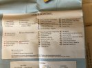
This is a screen shot of the caminos shown on the map. If there’s a map with more than 43 caminos showing in Iberia, I’d love to see it! Lots of obscure routes shown (e.g., Sagunto, Salnés, Manchego Argar) but not the ones you mention. Not sure if the kml tracks include any additional ones.
 
A friend just sent me a link to an official government site, run by the Instituto Nacional Geográfico. They are the wonderful people who produce the hard copy map that Ivar sells (which is indispensable for any serious camino planning outside the main routes, but is now unfortunately sold out).

This link takes you to a site with a long list and from there you can get to individual camino tracks. My friend says to open it on Google Earth and it will show you stage by stage. All of this is outside my range of abilities, since I use only GPX tracks, but for those who use KML it looks like it should be an excellent resource.
Yep. I've pointed to this site a few times when the topic of GPS tracks comes up on the forum and I imported all of their tracks into my Google Map of the Iberian Caminos. I should note that, if I remember correctly, Michael of Wise Pilgrim has suggested they don't update their tracks as often as some other sources.
 
Join our full-service guided tour and let us convert you into a Pampered Pilgrim!
All of this is outside my range of abilities, since I use only GPX tracks, but for those who use KML it looks like it should be an excellent resource.
Hi perigrina2000!
I found the ING site last year; it was a nudge from a forum member probably David above but cant remember exactly now!
I also use Gpx for Osmand+i have always used the site from the link below to convert kml to gpx without any issues !! (very easy to use)
Link https://kml2gpx.com/?results
Woody
A few of us have been sharing information about IGN for a while. I recall @Kanga asking for the link, when I checked, that was back in 2015. They have developed considerably since then. It is a great resource.
 
The one from Galicia (the round) and the one from Castilla & Leon. Individually numbered and made by the same people that make the ones you see on your walk.
They have developed considerably since then. It is a great resource.
Their free Android map app is a superb tool. You can zoom in to great detail for high quality topographical maps. I believe you can also superimpose kml tracks in the app but I haven't tried that option yet. No idea if there is an Apple version.
 
Their free Android map app is a superb tool. You can zoom in to great detail for high quality topographical maps. I believe you can also superimpose kml tracks in the app but I haven't tried that option yet. No idea if there is an Apple version.
They also have a Camino-specific app: https://play.google.com/store/apps/details?id=es.ign.caminosantiago
 
The focus is on reducing the risk of failure through being well prepared. 2nd ed.
With a little bit of work, you can create your own custom maps in Google My Maps: https://www.google.com/mymaps

To combine the KML files together so you can import them as one layer, you might find KML Merger useful as well: https://kmlmerger.com/

I've already spent far too much time having fun with this data! 😁
Of course you can. I link to mine in post #8 above. The trick is that Google My Maps has a limit on the number of map layers, so you can't put each Camino on its own layer.
 
I should note that, if I remember correctly, Michael of Wise Pilgrim has suggested they don't update their tracks as often as some other sources.
It's true. But I just had a look at two of the places on the Camino Portugués that most frequently appear incorrectly, and they are fixed. The route of of Lisbon remains incorrect though.

So all in all, still to be used at small scales.
 
Join our full-service guided tour and let us convert you into a Pampered Pilgrim!
Their free Android map app is a superb tool. You can zoom in to great detail for high quality topographical maps. I believe you can also superimpose kml tracks in the app but I haven't tried that option yet. No idea if there is an Apple version.
Only ‘basicos’ on the App Store sadly.
 
A friend just sent me a link to an official government site, run by the Instituto Nacional Geográfico. They are the wonderful people who produce the hard copy map that Ivar sells (which is indispensable for any serious camino planning outside the main routes, but is now unfortunately sold out).

This link takes you to a site with a long list and from there you can get to individual camino tracks. My friend says to open it on Google Earth and it will show you stage by stage. All of this is outside my range of abilities, since I use only GPX tracks, but for those who use KML it looks like it should be an excellent resource.
Excellent resource. Thanks.
 
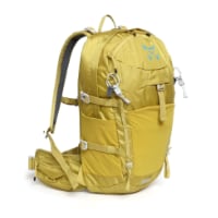
Technical backpack for day trips with backpack cover and internal compartment for the hydration bladder. Ideal daypack for excursions where we need a medium capacity backpack. The back with Air Flow System creates large air channels that will keep our back as cool as possible.

€83,-
...they don't update their tracks as often as some other sources.
I totally agree. The Camino paths are more fluid than one may think. The individual local powers that be, keep changing them, as they see fit, for improving the paths, creating a different path altogether to avoid highways, to take you into their town for amenities, despite a better path that walks along a river or whatever, etc, etc. IMHO it would take an ARMY of people walking and keeping this many Ways constantly updated.
 
A friend just sent me a link to an official government site, run by the Instituto Nacional Geográfico. They are the wonderful people who produce the hard copy map that Ivar sells (which is indispensable for any serious camino planning outside the main routes, but is now unfortunately sold out).

This link takes you to a site with a long list and from there you can get to individual camino tracks. My friend says to open it on Google Earth and it will show you stage by stage. All of this is outside my range of abilities, since I use only GPX tracks, but for those who use KML it looks like it should be an excellent resource.
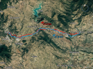
Thanks very much for that info peregrina, so I tried it out on a typical route for the Camino Frances hoping against hope it would AGREE with the route that I am using as my REFERENCE for my Web-App which also came from this forum purported also to be "official govt".

comparison1.pngHere is the comparison with the distances listed but the question remains where do the yellow markers fit into the mix, ie one or the other or a mix & match? Mine is red and yours blue
 
€2,-/day will present your project to thousands of visitors each day. All interested in the Camino de Santiago.
Thanks very much for that info peregrina, so I tried it out on a typical route for the Camino Frances hoping against hope it would AGREE with the route that I am using as my REFERENCE for my Web-App which also came from this forum purported also to be "official govt".
I didn't realize that there was a Spanish government department or agency responsible for defining the Camino routes. I would appreciate more information on that.

In the meantime, this is the explanation provided by IGN (here) where they describe the sources they used for the Camino mapping:

Stages provided by the Spanish Federation of Associations of Friends of the Camino de Santiago (FEAACS), and recovered by Spanish Jacobean associations. The routes have been created with the best tools available today, either by direct recording by many pilgrims, or through digital mapping by the IGN. But they should be considered as an aid to progress, never as a definitive route. They must be used with caution, always prioritizing what can be observed directly on the road. If you find any errors, or wish to make any comments, please contact: administracion@caminosantiago.org .
Fairly clearly they, as a mapping agency, are describing the Camino routes as best understood by the Spanish Jacobean associations, as one might expect a mapping agency to do. This is, in my view, quite different to defining the routes in some legalistic sense. I suspect there might be legal descriptions of such things somewhere, such as the definitions in the Galician heritage legislation that gives rise to the official routes recognised by the Cathedral of Santiago.

As for the two routes that you provided in your post, so far as I can ascertain from the image you have provided, the route that I walked following the waymarks both times I did the CF was the blue one. The red one seems to follow some secondary roads, and does an odd detour into the area of Cirauqai. That seems odd for a camino route. Clearly I don't know where you sourced this information from, but it certainly doesn't follow the walking route I used.
 
The Camino paths are more fluid than one may think.
This is such a good point. And it’s why I always search on wikiloc for recent tracks, in addition to getting a set of tracks from one of the “camino regulars” on wikiloc. On the popular caminos, like Francés, Primitivo, Norte, Portugués, etc, this isn’t much of an issue, but on the untraveled ones, it is always reassuring to know that I have several different sets of tracks that I can flip back and forth if things get confusing or unclear.

As @Elle Bieling points out, local organizations make little and big changes regularly, and it’s usually not a big deal. But no one should expect that any GPS track is going to be a perfect reflection of the most recent iteration of any camino.
 
The 2024 Camino guides will be coming out little by little. Here is a collection of the ones that are out so far.
On the popular caminos, like Francés, Primitivo, Norte, Portugués, etc, this isn’t much of an issue...
I just rewalked all three of the Portugués routes from Porto last fall, and the Coastal and the Senda Litoral from Porto has changed quite a bit. The building of new boardwalks and coastal paths are ongoing projects that makes routes clearer, easier and more waymarked. The Senda Litoral, according to some, including @jungleboy was a "made up route, " but is no longer made up and completely waymarked. All progress that allows the throngs of pilgrims that now walk these routes.

The Central was less changed, but it appears there is an ongoing war (judging by the painted arrows that are x'ed out) on the route into O Porriño, disputing the river walk vs the walk through town. Not to mention prior wars in the area before O Porriño, from Orbenlle trying to reroute pilgrims, that has now become two separate official routes.

Perhaps the route from Lisbon to Porto has changed less, with the exception of the lovely, new, six kilometer-long boardwalk after Sacovém on the way to Verdelha. I am rewalking the section after Alverca in a few months, so the jury is still out for me on this one!
I wasn’t clear what I was talking about, sorry. I think it’s much less of an issue because these routes are typically much better marked, and the consequences of getting off-route for a while are really pretty trivial. Totally agree that change is constant on all of the caminos.
 
I didn't realize that there was a Spanish government department or agency responsible for defining the Camino routes. I would appreciate more information on that.

In the meantime, this is the explanation provided by IGN (here) where they describe the sources they used for the Camino mapping:


Fairly clearly they, as a mapping agency, are describing the Camino routes as best understood by the Spanish Jacobean associations, as one might expect a mapping agency to do. This is, in my view, quite different to defining the routes in some legalistic sense. I suspect there might be legal descriptions of such things somewhere, such as the definitions in the Galician heritage legislation that gives rise to the official routes recognised by the Cathedral of Santiago.

As for the two routes that you provided in your post, so far as I can ascertain from the image you have provided, the route that I walked following the waymarks both times I did the CF was the blue one. The red one seems to follow some secondary roads, and does an odd detour into the area of Cirauqai. That seems odd for a camino route. Clearly I don't know where you sourced this information from, but it certainly doesn't follow the walking route I used.
It is called (ES) Camino Frances (Saint-Jean-Pied-de-Port - Santiago de Compostela) and I think it is klm

I joined this forum for the express and expressed purpose of finding the "correct" file for Camino Frances before I wasted several months making Web-Apps barking up the wrong trail and that was the one I was directed to.

But no sweat as it is quite clear now that no "correct" path exists so I will just keep going with this one thanks
 
Ideal sleeping bag liner whether we want to add a thermal plus to our bag, or if we want to use it alone to sleep in shelters or hostels. Thanks to its mummy shape, it adapts perfectly to our body.

€46,-
But no sweat as it is quite clear now that no "correct" path exists so I will just keep going with this one thanks
I had a look at your flythrough of this section. I did suspect that the red track might have been a cycling route, and the flyover confirms for me that it definitely isn't a route that would be normally used by walkers., especially any following the way markings where it leaves Puente la Reina. So to suggest there is no correct route might reflect a purely technical view that there are many variations, and your selection might satisfy some small number of cyclists, but it might surprize the majority of walkers.

I would make the same observation about many of the other tracks you have selected. It appears in all the ones that I have watched so far that you have used a cycling track, and not an alignment that would be attractive to a walker. In many it is quite obvious when the track you use follows a longer road when a shorter path is clearly available. To give you an example, on Trackcard6, most of the remainder of the route you have used from about 1:42 is on a major road. I suspect those who have walked this would not recognize very much.

Where do you want to take this project? It might represent a great resource for cycling pilgrims, but as it stands, doesn't seem to have much to offer a walking pilgrim. I don't know how much work there would be to extend this to capture the walking routes and include them, but I think it would add to the credibility of your work to do that. It brought back many memories where it did follow the walking paths and I would have enjoyed more of that.
 
Last edited:
I had a look at your flythrough of this section. I did suspect that the red track might have been a cycling route, and the flyover confirms for me that it definitely isn't a route that would be normally used by walkers., especially any following the way markings where it leaves Puente la Reina. So to suggest there is no correct route might reflect a purely technical view that there are many variations, and your selection might satisfy some small number of cyclists, but it might surprize the majority of walkers.

I would make the same observation about many of the other tracks you have selected. It appears in all the ones that I have watched so far that you have used a cycling track, and not an alignment that would be attractive to a walker. In many it is quite obvious when the track you use follows a longer road when a shorter path is clearly available. To give you an example, on Trackcard6, most of the remainder of the route you have used from about 1:42 is on a major road. I suspect those who have walked this would not recognize very much.

Where do you want to take this project? It might represent a great resource for cycling pilgrims, but as it stands, doesn't seem to have much to offer a walking pilgrim. I don't know how much work there would be to extend this to capture the walking routes and include them, but I think it would add to the credibility of your work to do that. It brought back many memories where it did follow the walking paths and I would have enjoyed more of that.
Thanks a lot for that input so as far as where I want to take it I am half way on Frances and similar on Norte so I don't mind changing my base file IF you have something better so by all means point me to what you consider as the preferred files for these Caminos.
 
St James' Way - Self-guided 4-7 day Walking Packages, Reading to Southampton, 110 kms
Thanks a lot for that input so as far as where I want to take it I am half way on Frances and similar on Norte so I don't mind changing my base file IF you have something better so by all means point me to what you consider as the preferred files for these Caminos.
I have been recommending ING as a source for over a decade. They have changed from the .gpx format to .kml in that time, but it seems you have the skills to deal with that.

The other resource you might find useful is the Dutch Confraternity. There is a link in the resources section, here.
 
I have been recommending ING as a source for over a decade. They have changed from the .gpx format to .kml in that time, but it seems you have the skills to deal with that.

The other resource you might find useful is the Dutch Confraternity. There is a link in the resources section, here.
Well I thought I WAS using ING, so could you please give a link to the ING files (any format is fine) you are recommending for Camino Frances and Camino Norte
 
Well I thought I WAS using ING, so could you please give a link to the ING files (any format is fine) you are recommending for Camino Frances and Camino Norte
I'm not sure what you are now asking for. The ING link is in the first post in this thread. I have checked it, and it works. You can do an in-page search for the routes you need if you find it difficult to navigate. For the Camino Frances there are three sections, the main route from Puente la Reina and the two sections that join there from SJPP and Jaca. There are a dozen sections for the northern camino routes, including the Camino del Norte.
 
Join our full-service guided tour of the Basque Country and let us pamper you!
I'm not sure what you are now asking for. The ING link is in the first post in this thread. I have checked it, and it works. You can do an in-page search for the routes you need if you find it difficult to navigate. For the Camino Frances there are three sections, the main route from Puente la Reina and the two sections that join there from SJPP and Jaca. There are a dozen sections for the northern camino routes, including the Camino del Norte.
Thanks once again Doug and I will redo my trackcard6 using the ING version above to see if there is an improvement.

But maybe to explain my confusion I should explain "where I am coming from and below is a snippet from the UKNational trails site for the North Downs Way which is virtually the same as the Pilgrims Way to Canterbury.

The map is a digital version of the OS paper map which is as British as a cold pork pie and the choice for navigation for most walkers (even have waterproof versions). But you will see that for digitally inclined folk you can download the exact same map.

And it is so organised that the yellow warning tells you of bridge repairs and the bus service to avoid the issue (as the walk must go on!).

AND we know this is the single correct route with waymarkers as there are dedicated trail managers/wardens that install/check them.

Obviously none of that is replicated for Caminos which is a "free for all" hence my confusion.

My attraction for the North Downs Way originally was that in 2016 it was the first National Trail to be fully covered by some 10,000 Google Trekker Street View Panoramas with those same wardens having to lug the 28 kg beasts over the whole track. Camino tracks are generally not so well covered once the route "goes bush".

But on the upside SatNav tracking for Caminos is generally over 95% correct whereas for the North Downs Way it was so bad I left it out of my Web-Apps, that is until 2023 when I spent a good deal of time with Google to make it 100% active when Google agreed to "talk to" people who wanted to help.doug10.png

Then the "govt" backed Trekker plan for all UK Trails went bottoms up with only 15% complete, hence my new interest in Iberian Peninsular incl Camino. From here, who knows but I will try to at least complete the Camino Frances.
 
I wrote to them last week about this map:

They are starting up the printers (just for me I think) will print a few hundred. I think they said late January, early February. So will have it back in stock soon.
This is now back in stock by the way...
 
Thanks once again Doug and I will redo my trackcard6 using the ING version above to see if there is an improvement.

But maybe to explain my confusion I should explain "where I am coming from and below is a snippet from the UKNational trails site for the North Downs Way which is virtually the same as the Pilgrims Way to Canterbury.

The map is a digital version of the OS paper map which is as British as a cold pork pie and the choice for navigation for most walkers (even have waterproof versions). But you will see that for digitally inclined folk you can download the exact same map.

And it is so organised that the yellow warning tells you of bridge repairs and the bus service to avoid the issue (as the walk must go on!).

AND we know this is the single correct route with waymarkers as there are dedicated trail managers/wardens that install/check them.

Obviously none of that is replicated for Caminos which is a "free for all" hence my confusion.

My attraction for the North Downs Way originally was that in 2016 it was the first National Trail to be fully covered by some 10,000 Google Trekker Street View Panoramas with those same wardens having to lug the 28 kg beasts over the whole track. Camino tracks are generally not so well covered once the route "goes bush".

But on the upside SatNav tracking for Caminos is generally over 95% correct whereas for the North Downs Way it was so bad I left it out of my Web-Apps, that is until 2023 when I spent a good deal of time with Google to make it 100% active when Google agreed to "talk to" people who wanted to help.View attachment 162812

Then the "govt" backed Trekker plan for all UK Trails went bottoms up with only 15% complete, hence my new interest in Iberian Peninsular incl Camino. From here, who knows but I will try to at least complete the Camino Frances.
Good news doug, Google has agreed yesterday to add your 2018 diversion after O Areal, so try it again!
 
Very light, comfortable and compressible poncho. Specially designed for protection against water for any activity.

Our Atmospheric H30 poncho offers lightness and waterproofness. Easily compressible and made with our Waterproof fabric, its heat-sealed interior seams guarantee its waterproofness. Includes carrying bag.

€60,-
Good news doug, Google has agreed yesterday to add your 2018 diversion after O Areal, so try it again!
Two points:
a. it's not my 'diversion', it is the Camino route. There are a couple of alternatives here.
b. you are missing the general point. The argument that all of something is true is easily falsified by the presentation of just one example of the premise not being true. I have shown that such a weakness exists. I don't expect it will be the only one.

No doubt Google could fix these up one at a time, as I am sure other mapping providers do when they are informed about errors in the GIS information underlying their products. It won't give Google Maps the functionality I know that I need from a navigation tool for walking, nor will I be confident about the information that it is using. I might use it from time to time when I am driving, but even then, I am more likely to rely on a Garmin gps than on Google.
 
On the contrary doug your "just one example" was a great help to me as I am presently making a Web-App for that very trip (from the Portuguese border) and for the entire 125 km there were just 18 spots where Google had not activated sections of the IGN route which are presently with Google for their approval to activate.

So with your contribution the WHOLE of this route should be available in about 2 weeks when I complete it for folks like me handicapped physically or financially to make a full Virtual Tour of the route, and as a bonus "able bodied pilgrims" will be free to use it to actually walk the route - or use Garmen etc if they wish
 
Hi doug

These pilgrims in this Street View of May 2023 are at O Pobo coming into Ponteverdra and as you will know they are needing to make a decision of going on the boring official path to the right or the "river path" alternative route to the left which we can see from numerous Google Local Guides SHARING their Street View panos is quite an experience.

I too would like to share this with the world (and Estavez family) in my Web-App of "The Estavez Way" but I really don't have the time to generate a file for this alternative route. Do you have a garmin etc file you would be willing to share for the common good like you did at O Areal?twopaths.png
 
A selection of Camino Jewellery
The first few posts have some good information on the subject of the thread. However, further discussion of the details of personal mapping projects should probably go to private Conversations.
 
I don't want to agitate but for a dummies guide (which work for iPads, iPhones and apple laptops/desktops with the M1 chip) for those wanting detailed maps with the "track" for the CF an option that works today is using the "Organic Maps" app (open source, donations welcomed by the developers).

The result will align with be a track route which aligns with the notorious "blue route" referred to in post #24 and #26 above.

The segmented "track" files you want are in a neat table provide by our friends a Stingy Nomads at:
https://stingynomads.com/camino-frances-walking-itinerary/

Step 1 install Organic Maps download links from https://organicmaps.app/ parent site with link to Apple Store and others).

Step 2 open Organic Maps search (click the magnifying symbol) for SJPD (in full) or you preferred starting point to start you first map download. Stop! you can play with the maps later, move to Step 3.

Step 3 download the relevant "track" files from the Stingy Nomads article above ("save as" is you friend. create a folder on your preferred cloud). You don't need to rename the files as the will appear as Stage 1 - Stage 33 matching the stage in table in the Nomad article.

Note. As you upload track files into Organic Maps it will prompt you with specific "map downloads" required for the track file.

Stage 4. Find the download file (for the SJPD starting point download will look like this: Stage-1-Camino-Frances.gpx) double click to open the file (if you're given a choice select the Organic Maps app)

Step 5. the first file upload has worked. Pat yourself on the back. Repeat Step 3 to download the rest of the track files and Step 4 to open them.

Step 6. Finished. Yes and No. Enjoy the real fun starts now as you start magnifying the maps to see the details.
 

Most read last week in this forum

I realize every ounce matters when carrying backpack and not shipping luggage ahead. However, I know that the Spaniards are big into meat and potatoes, and not so much produce. I am thinking of...
Hola, I gearing up to start my 1st CdS and have seen people recommended sleeping bag liners to protect against bed bugs. Do these help or is it a myth? Should I add the extra weight of bringing one?
I’ve been stressing about charging my devices, so just want to make sure. I have this 4port Powered USB hub which I’m connecting to an adapter to fit European (at least Spain, since I know it...
So I have heard common wisdom is to bring a silk liner for your Camino (+/- a sleeping bag depending on your preference and season). Specifically regarding silk liners, all of the ones I've...
Michael @wisepilgrim had mentioned a new feature that he was developing for Wise Pilgrim, and it looks like it is now in operation. You can check the app and see in real time how many beds are...
Hi! I am 15 days out from my Camino, and suddenly my Buen Camino app is crashing every time I try to look at my stages! I have rebooted my phone, done the "restore app" within the app, rebooted...

❓How to ask a question

How to post a new question on the Camino Forum.

Similar threads

Forum Rules

Forum Rules

Camino Updates on YouTube

Camino Conversations

Most downloaded Resources

This site is run by Ivar at

in Santiago de Compostela.
This site participates in the Amazon Affiliate program, designed to provide a means for Ivar to earn fees by linking to Amazon
Official Camino Passport (Credential) | 2024 Camino Guides
Back
Top