Just came into Portomarin an hour ago. Did the
Camino Frances in 2013.
The 2013 route went east and hit the road to east of the bridge. You crossed on the right side of the bridge, with a great view of the old Roman bridge below you, at least when the water level was low, as it was in 2013.
The new route hits the road west of the bridge. As you approach the bridge you can see the old Roman bridge. You cross on the left side of the new bridge and, at least with today's low water, get a great view of the Roman ruins from the old town.
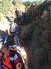
The new route gives you a choice. You can stay on the road, more or less straight or turn right and go down the trail. There are two stone Camino stone markers, offering contradicting guidance. There is a sign, clearly stating in several languages, one of which is English, that the trail includes a dangerous pedestrian passage.
The trail is great until the last descent to the road, which is very steep and rocky. This 68 year old had no trouble with it, but I started in Le Puy and the Aubrac gave me pretty good training. If I do it again, I'll take the same trail unless it is raining.
At the same time, I must admit that this 68 year old is, it has to be said, slow on the descents; I created a bottle neck of at least 15 pilgrims, including two bikers (!).


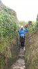


 Being the coward I am, I went back and took the 'newish' path on the south - I turned right when I got back to the sign.