
-
For 2024 Pilgrims: €50,- donation = 1 year with no ads on the forum + 90% off any 2024 Guide. More here.
(Discount code sent to you by Private Message after your donation)
Search 69,459 Camino Questions
You are using an out of date browser. It may not display this or other websites correctly.
You should upgrade or use an alternative browser.
You should upgrade or use an alternative browser.
Are the distances on Gronze correct?
- Thread starter Luka
- Start date

The one from Galicia (the round) and the one from Castilla & Leon. Individually numbered and made by the same people that make the ones you see on your walk.
- Time of past OR future Camino
- First: Camino Francés 2002; most recent: Norte/Primitivo 2019
The most common negative feedback I get on the guidebook is that the distances are all 1-2km shorter than the reality. It's like there's some grand conspiracy out there, among guidebook authors, to make everything sound easier than it is. Seems odd when you think about it--wouldn't we want to conspire in the other direction? Nobody ever complains when a route turns out to be 1-2km shorter than expected, but the opposite is unvarnished misery.
Ultimately, from my perspective, there are two main drivers of what I would argue is a misperception here. First, distances depend on where you're measuring from and to. If I set the center of San Sebastián as the "endpoint," but people are walking to Albergue La Sirena at the end of town, they are in fact going 2km farther.
The bigger issue, though, is all of the different devices people are using to measure their distance--phone GPS, fitbits, etc. If you look at those recordings, you often won't find a perfectly straight line. Instead, the gps pings around--especially if there are buildings, trees, mountains, etc. One of the more annoying and mundane things we have to do when prepping a guidebook is take those imperfect recordings and smooth them out, manually adjusting each and every track point. I suppose it's a form of meditation.
In any case, a funny thing happens when you smooth out all those track points in a gps recording. You tend to shave off a kilometer.
Luka
Veteran Member
- Time of past OR future Camino
- Next: Camino Sanabrés (May 2024)
Thanks for your elaborate answer, @Dave! And sorry to hear about all the hassle guidebook writers have to go through...  Yes, I reckoned I shouldn't take differences with wikiloc tracks too seriously. Also because people often walk a few 100 meters more to have a look at a view, a church or search for a bar. But I just compared a couple of stages between Gronze and Eroski and also then the Gronze stages are roughly about 1 km shorter than the ones on Eroski. But maybe Eroski adjusted their stages because of complaints?
Yes, I reckoned I shouldn't take differences with wikiloc tracks too seriously. Also because people often walk a few 100 meters more to have a look at a view, a church or search for a bar. But I just compared a couple of stages between Gronze and Eroski and also then the Gronze stages are roughly about 1 km shorter than the ones on Eroski. But maybe Eroski adjusted their stages because of complaints? 
Technical backpack for day trips with backpack cover and internal compartment for the hydration bladder. Ideal daypack for excursions where we need a medium capacity backpack. The back with Air Flow System creates large air channels that will keep our back as cool as possible.
€83,-
€83,-
- Time of past OR future Camino
- 2012
It’s important to remember that kilometers walked after lunch are approximately 50% longer than kilometers walked immediately after breakfast
- Time of past OR future Camino
- First: Camino Francés 2002; most recent: Norte/Primitivo 2019
- Time of past OR future Camino
- First: Camino Francés 2002; most recent: Norte/Primitivo 2019
I also have a long-standing theory that kms walked before sunrise don't count. The body's internal pedometer only functions with daylight.It’s important to remember that kilometers walked after lunch are approximately 50% longer than kilometers walked immediately after breakfast

Down bag (90/10 duvet) of 700 fills with 180 g (6.34 ounces) of filling. Mummy-shaped structure, ideal when you are looking for lightness with great heating performance.
€149,-
€149,-
- Time of past OR future Camino
- Too many and too often!
My father-in-law worked for a company which made and serviced high-accuracy maritime GPS systems. One of their engineers was sent out to find out why the two independent systems on a ship were consistently reading about 10 metres difference between the sets. Antenna for one on the port side, antenna for the other on starboard. The beam of the ship was about 10 metres!The bigger issue, though, is all of the different devices people are using to measure their distance--phone GPS, fitbits, etc.

- Time of past OR future Camino
- 2012, 2015, 2018, 2019, 2022, 2024
Some are longer, same are shorter, some are exactly the same. Measuring distance is a very inexact science. The precise route taken by different walkers varies, the topography is uneven and routes have an annoying habit of being changed. If you don´t believe me, try taking a walk with someone who, like you, is using a satnav or GPS and at the end of the walk, comparing the distance you are both supposed to have walked. They will be different. The quoted distances are usually close enough to be a rough guide.
- Time of past OR future Camino
- Past: a few
Last: Sanabres
Next: St Olav's Way
@Dave talks about cleaning up tracks to remove irregularities. In addition to those he has already identified, I have found that GPS units have a social life of their own. Whenever I stopped for a coffee and put my pack down with my GPS in it, the GPS would wander around until I put on my pack and started walking again. I can only think that it was seeking out a friend and having a chat. A couple of coffee stops and my GPS would walk around 5% to 10% more than I did.
Reflecting on what @dick bird has said, when I walk with others who are tracking their walks, I also find is very rare to get agreement on the distance we have walked. On walks that I lead, the best I can do is let people know what was recorded on my GPS. It is rare for anyone to disagree and suggest that their, different, measurement is more accurate. It doesn't fuss me, and I let them share their little delusion rather than entering into a discussion like this about why neither of us can really tell whose device was closest to the actual distance.
The other circumstance where I find differences is when I have walked a well established distance, like doing a lap of an athletics track. While I wear what I think of as a very competent sports watch when I am racing, it regularly reports a shorter distance than I know I have walked. If one looks at the track on a map, it is clear why. The track never completely accurately follows the curve of the track. Sometimes it appears inside the actual curve of the actual track, at others it looks like I walked in the outside lanes. I don't ever do that!
I haven't bothered responding to the survey. My own view is that even with the best will in the world, I would be guessing.

The 2024 Camino guides will be coming out little by little. Here is a collection of the ones that are out so far.
- Time of past OR future Camino
- Frances 15,16,18
VdlP 23, Invierno 23, Fisterra 23
I have always found Gronze to be fairly accurate.
You actual distance might be a bit longer becuase:
You actual distance might be a bit longer becuase:
- You wandered a few hundred metres back and forth looking at things.
- You finished on the 'far side' of a town / village.
- You may ended the day before on the 'near side' of town.
- The route may have alterred slightly in recent times.
- You forgot to turn off your GPS/Mapping whilsy you checked in and went shoppning (done that)
- Time of past OR future Camino
- Francés, Norte, Salvador, Primitivo, Portuguese
You need another option for the poll:
Some are longer, same are shorter, some are exactly the same.
- Time of past OR future Camino
- Many
I say often that the distances as published are the distances between towns, a distance that is both measurable and know. It is an accurate distance.
And most importantly it is a distance that does not consider whatsoever how YOU walk between two towns…. that’s what your device will tell you. But it will only be able to tell you after you have done it.
And most importantly it is a distance that does not consider whatsoever how YOU walk between two towns…. that’s what your device will tell you. But it will only be able to tell you after you have done it.

Join our full-service guided tour of the Basque Country and let us pamper you!
- Time of past OR future Camino
- Many, various, and continuing.
I wrote guidebooks back in the stone age, when WisePilgrim was just a SmartyPants, and GPS was still in its infancy. I got out of the business, having learned that Hell Hath No Fury LIke a Wet Pilgrim with Wrong Directions.
People wanted to kill me, over the tiniest detail. My life was already too short for that. So I handed it all over to more technically savvy young bucks... and the eternal Peregrina2000.
People wanted to kill me, over the tiniest detail. My life was already too short for that. So I handed it all over to more technically savvy young bucks... and the eternal Peregrina2000.
- Time of past OR future Camino
- Us:Camino Frances, 2015 Me:Catalan/Aragonese, 2019
The GPS distance is calculated by summing the distance between each of the points making the track. The more points between the start and end of the recorded track the more accurate the distance you walked should be. Different apps may have different defaults for the amount of time between logging the trackpoints and different users of the same app may have changed the default value to different amounts of time.
Let's say you are walking along a series of switchbacks and you've set the time between recording points to twenty seconds. This will likely show on a map that you have been taking shortcuts and not walking around the turns. This track will show a shorter distance than another GPS device carried on the same trip where the recording interval is one second because the second device records the turns. Things can go off also if you weave along a road or not.
Doug mentioned the GPS wandering around while he is sitting. Inaccuracies in the position are being recorded and added to the accumulated distance between trackpoints. I try to stop this inaccuracy by pausing the app but it never really works because I forget to restart the GPS when I start walking again. At least until the device says "Hey, dummy! You're getting far away from your stop point and yet you're saying you don't want me to record trackpoints. What do you want me to do?"
Edit: Some more confusion can occur with Wikiloc. A member may have recorded a long track using a short time interval between trackpoints and so Wikiloc may say the track is 25 km long. If you download the smaller version (100 trackpoints or fewer) the Wikiloc app might tell you the track is a shorter distance. Also this verison will show longer straight line segments along the track.
FWIW, not too long ago I had our propery surveyed by a crew using a super accurate GPS device. They measured elevation to a tenth of a foot (3 cm).tenth of an inch (2.5 mm).
Let's say you are walking along a series of switchbacks and you've set the time between recording points to twenty seconds. This will likely show on a map that you have been taking shortcuts and not walking around the turns. This track will show a shorter distance than another GPS device carried on the same trip where the recording interval is one second because the second device records the turns. Things can go off also if you weave along a road or not.
Doug mentioned the GPS wandering around while he is sitting. Inaccuracies in the position are being recorded and added to the accumulated distance between trackpoints. I try to stop this inaccuracy by pausing the app but it never really works because I forget to restart the GPS when I start walking again. At least until the device says "Hey, dummy! You're getting far away from your stop point and yet you're saying you don't want me to record trackpoints. What do you want me to do?"
Edit: Some more confusion can occur with Wikiloc. A member may have recorded a long track using a short time interval between trackpoints and so Wikiloc may say the track is 25 km long. If you download the smaller version (100 trackpoints or fewer) the Wikiloc app might tell you the track is a shorter distance. Also this verison will show longer straight line segments along the track.
FWIW, not too long ago I had our propery surveyed by a crew using a super accurate GPS device. They measured elevation to a tenth of a foot (3 cm).
Last edited:
- Time of past OR future Camino
- Most years since 2012
Ha! I have noticed that. I have a weekly target to walk, at home. I tell myself sternly to turn OFF the tracking as soon as I arrive home, and not cheat by letting it wander around all day accumulating distance.the GPS would wander around until I put on my pack and started walking again.

The 9th edition the Lightfoot Guide will let you complete the journey your way.
Kiwi-family
{Rachael, the Mama of the family}
- Time of past OR future Camino
- walking every day for the rest of my life
At the risk of derailing the thread (oops sorry), I'm doing the opposite @C clearly ! I have a maximum distance I am NOT to exceed at the moment (rehabbing tendons) and I get to record all walking I'm doing on physio's orders (just by carrying my phone with me)....today I exceeded my distance simply by walking around the garden lopping off branches and pulling weeds - admittedly for four hours.Ha! I have noticed that. I have a weekly target to walk, at home. I tell myself sternly to turn OFF the tracking as soon as I arrive home, and not cheat by letting it wander around all day accumulating distance.
As for Gronze, I use it as a guide, but mostly expect to do more and then I'm rarely disappointed.
- Time of past OR future Camino
- Olvidado/San Salvador/Primitivo 2019
That’s why I don’t eat lunch!It’s important to remember that kilometers walked after lunch are approximately 50% longer than kilometers walked immediately after breakfast
- Time of past OR future Camino
- Camino Frances Fall 2023
On our first Camino, totally tired out, we stopped for the night at a beach resort which rented little cabins. It was raining, we took one. At the bar was a sign showing the distances to all the nearby towns. The distance to the town we had walked all day from was ------- 10 MINUTES! By car. I haven't been too concerned about exact distances since then. Buen Camino

The one from Galicia (the round) and the one from Castilla & Leon. Individually numbered and made by the same people that make the ones you see on your walk.
K_Lynn
Buen Camino!
- Time of past OR future Camino
- Frances 2021, Ingles 2023
I felt that the distances between stages were about 4km longer than suggested lol. Part of the issue is walking pace. My walking pace with a loaded pack at home is about 6kph. On Camino my walking pace is 4kph. At home a 20km walk is about 4.5 hours (allowing for a break) and on Camino I would take 5 to 6 hours for that distance. After the first week I learned to add 2 hours to my expected walking day.
- Time of past OR future Camino
- 2024
Does Gronze use a "proper" SatNav track or just a rough file generated by a handheld tracking device?Is it me or are a lot of stages a bit longer in reality than mentioned on Gronze? It seems like you often need to add 1 or 2 kms.
- Time of past OR future Camino
- Past: a few
Last: Sanabres
Next: St Olav's Way
I don't understand the distinction you are making here. Would you please explain what you want to know.Does Gronze use a "proper" SatNav track or just a rough file generated by a handheld tracking device?
The 2024 Camino guides will be coming out little by little. Here is a collection of the ones that are out so far.
- Time of past OR future Camino
- 2024
Well the most accurate way I know of measuring distance is to import the track into Google Earth. Then it will tell you the exact distance "on the flat" as well as the cumulative ups and downs which you might want to add in if you wish. So to answer the OP question I was asking about the actual file being used by gronze to compute distance. As someone else mentioned a recorded file that makes a reading every 50 m (or so) is going to be less than an AI generated file that perfectly "smooths" out the corners.I don't understand the distinction you are making here. Would you please explain what you want to know.
- Time of past OR future Camino
- Us:Camino Frances, 2015 Me:Catalan/Aragonese, 2019
FWIW, in the US Google Maps pretty much computes walking time using a speed of three miles per hour. This is a bit slower than five kilometers per hour. At 5 kph, on average, you are walking 1.4 meters per second.As someone else mentioned a recorded file that makes a reading every 50 m (or so) is going to be less than an AI generated file that perfectly "smooths" out the corners.
- Time of past OR future Camino
- 2024
The question was about distance and not speed as I read it. So my reply was about determining the correct distance for a given walk and Google Earth is the Google tool for that job.FWIW, in the US Google Maps pretty much computes walking time using a speed of three miles per hour. This is a bit slower than five kilometers per hour. At 5 kph, on average, you are walking 1.4 meters per second.
Google Maps on the other hand uses a SatNav algorithm (same one as in Google MyMaps) that will also compute distance (AS LONG AS the whole track is ACTIVE) as well as estimating time (walking, cycling, motor vehicle). And yes it uses about 3 miles per hour for walking, but only on the flat. The algorithm corrects for ups and downs - try it out by making a SatNav between two places at different elevations, observe the time and then hit the reverse button and observe the new time.
What it does not (yet) do is allow a slower speed downhill for those with "dickey knees" but that could change tomorrow.

The 9th edition the Lightfoot Guide will let you complete the journey your way.
- Time of past OR future Camino
- 2012, 2015, 2018, 2019, 2022, 2024
I suspect Gronze doesn´t measure the distances at all. They tend to collate information from members and contributors and publish it. I am sure a lot of the information in Gronze is sourced, Wiki fashion, in this way. The problem is that the distance between two geographical locations, no matter how accurately it is measured, is not the same as the distance travelled by an individual when walking between the same two points.Well the most accurate way I know of measuring distance is to import the track into Google Earth. Then it will tell you the exact distance "on the flat" as well as the cumulative ups and downs which you might want to add in if you wish. So to answer the OP question I was asking about the actual file being used by gronze to compute distance. As someone else mentioned a recorded file that makes a reading every 50 m (or so) is going to be less than an AI generated file that perfectly "smooths" out the corners.
- Time of past OR future Camino
- 2024
With respect, we seem to put the cart and horse in different positions. My understanding of the term "guide" is to use the best available technology to provide the FACTS about a certain task which in this case is to walk/bike/(or even crawl in some religions) from A to B.I suspect Gronze doesn´t measure the distances at all. They tend to collate information from members and contributors and publish it. I am sure a lot of the information in Gronze is sourced, Wiki fashion, in this way. The problem is that the distance between two geographical locations, no matter how accurately it is measured, is not the same as the distance travelled by an individual when walking between the same two points.
As an engineer (retired) if all the cross checks on my work don't say A OK then I don't sleep that night.
Then once I have signed off as "happy" or at least as Ennis del Mar would say "good enough", then if a person using my guide wants to wander all over the road, visit a church etc then it is up to THEM to add that into the base total.
- Time of past OR future Camino
- Past: a few
Last: Sanabres
Next: St Olav's Way
Thank you for this, but I don't know that it really explains whether you are using the term 'SatNav' in some unusual way. You seem to use it to refer to a variety of GIS products, some of which I wouldn't consider to be satellite navigation products per se. Google Earth is one of those, and it is touching to see such faith being expressed in its accuracy. As a Garmin user, I can think of similar Garmin mapping products that I would use in preference to Google Earth, and I am sure that there are many others that offer similar or better quality results.Well the most accurate way I know of measuring distance is to import the track into Google Earth. Then it will tell you the exact distance "on the flat" as well as the cumulative ups and downs which you might want to add in if you wish. So to answer the OP question I was asking about the actual file being used by gronze to compute distance. As someone else mentioned a recorded file that makes a reading every 50 m (or so) is going to be less than an AI generated file that perfectly "smooths" out the corners.
I also think that your statement that a recorded file (I presume you mean a track, in this context) is going to be shorter than one that 'perfectly "smooths" out the corners' is the wrong way around. There is only one circumstance where it will be shorter, and that is where the recorded track is consistently inside the line of a curve. I don't think this is would apply to much of the camino.
I am not sure what product you have in mind that is using AI to generate track information. While I haven't looked in detail, it seems most of the mapping and navigation apps rely on the mathematics of spherical geometry, and its practical application in navigation or surveying on the less than perfect sphere we live on. That clearly isn't AI, so I am wondering what it is you are referring to here.
In relation to the current discussion, I am of much the same view as @dick bird. We could engage in an unending search for greater and greater levels of accuracy but have little real, practical, impact on pilgrims. We will become like the Galician majones with km distances presented to the third decimal place when you could add much more than a metre when you next get off the route to get a coffee.
Last edited:

A selection of Camino Jewellery
- Time of past OR future Camino
- 2012, 2015, 2018, 2019, 2022, 2024
That is kind of the point I am trying to make. Firstly, I don´t think Gronze or any other guide uses cutting edge technology to determine distances on the camino. At the very best they get their information from somebody else, in other words their information is second hand. Secondly, what the user of a guide wants, in most cases, is a fairly reliable indication of how far they themselves are going to walk, cycle, ride, hop, crawl or successively prostrate themselves that day, not a measurement down to a fraction of a millimetre. There are going to be all kinds of factors affecting the accuracy of such a measurement (apart from anything else, roads and paths do not stay in the same place for very long) and experienced pilgrims know and accept this. Anything within 500mts either way is fine. It´s just that we like to have a bit of a laugh about it now and again.My understanding of the term "guide" is to use the best available technology to provide the FACTS about a certain task which in this case is to walk/bike/(or even crawl in some religions) from A to B.
Absolutely. Or we could conduct a search for the Holy Grail. The result will be the same.We could engage in an unending search for greater and greater levels of accuracy
- Time of past OR future Camino
- Us:Camino Frances, 2015 Me:Catalan/Aragonese, 2019
FWIW, in the US Google Maps pretty much computes walking time using a speed of three miles per hour. This is a bit slower than five kilometers per hour. At 5 kph, on average, you are walking 1.4 meters per second.
The question was about distance and not speed as I read it. So my reply was about determining the correct distance for a given walk and Google Earth is the Google tool for that job.
I started out with a FWIW (for what it's worth) because it isn't worth too much for most people following a track. For someone creating one though they may want to adjust the number of points they will be recording. For someone walking at an average speed of 5 kph that wants trackpoints about 50 meters apart he could adjust the recording instrument's settings to be for a period of every 36 seconds.
This may not be useful for most but maybe useful for some. FWIW.
jflorez
Joe Florez
- Time of past OR future Camino
- Camino Frances: May/Jun (2018), Sept/Oct (2021)
This post and its replies has been an entirely entertaining read. I'm not aware of any other Camino forum, board, blog or vlog whose members will devote as much energy to topics such as discussing the method for, and pitfalls of, determining the precise accuracy of distance measured between stages and published by another website. I mean it sincerely; I don't mean to be sarcastic. I always learn something new out of these esoteric discussions. 
With regard to the topic, I just want a ballpark* figure to know how much further before I can relax and enjoy an ice cold caña. "it's not far now" as a response by anyone around me is an entirely acceptable measure of distance in my book. First round is on me! Cheers
*Ballpark Figure: An acceptable, roughly accurate approximation, as in "I know you can't tell me the exact cost; just give me a ballpark figure". This term alludes to a baseball field, which is always an enclosed space.
Down bag (90/10 duvet) of 700 fills with 180 g (6.34 ounces) of filling. Mummy-shaped structure, ideal when you are looking for lightness with great heating performance.
€149,-
€149,-
- Time of past OR future Camino
- 2012
I think the quest for the Grail is more likely to produce a finite result.Absolutely. Or we could conduct a search for the Holy Grail. The result will be the same.
- Time of past OR future Camino
- Recent:Norte/Muxia- Spring '23
MadridWay- Fall '23
I have only read the first several posts, but as long as I get a good estimate from Brierley or a Cicerone guide book, and/or Gronze (which they do), I don't really care if it is one or two kilometers off. I do not wear a fit bit or other tracking device to be concerned, and "it is what it is". The stages I choose to spend the night are never really affected anyway by small differences.
- Time of past OR future Camino
- 2012
I think if I was running an Olympic 10,000 metres or the London marathon I’d like to be fairly confident that some one had managed to measure the distance with a reasonable degree to of accuracy. Tho’ as evry fule know to run 10’m on an affletics track you have to run round the inside not the outside and you must not run off t’ the pub halfway round…I have only read the first several posts, but as long as I get a good estimate from Brierley or a Cicerone guide book, and/or Gronze (which they do), I don't really care if it is one or two kilometers off. I do not wear a fit bit or other tracking device to be concerned, and "it is what it is". The stages I choose to spend the night are never really affected anyway by small differences.
As @Camino Chrissy says the plus or minus a bit on a walk through the Spanish countryside is unlikely to cause to much distress. Unless, of course, it’s raining Perros y Gatos; your blisters are throbbing and the idiot you’re walking with is whistling a happy tune. In which case 1 metre of inaccuracy is a kilometer of pain.
Damn all surveyors to hell….
Last edited:
The 2024 Camino guides will be coming out little by little. Here is a collection of the ones that are out so far.
- Time of past OR future Camino
- Us:Camino Frances, 2015 Me:Catalan/Aragonese, 2019
Off topic but I suggest reading this article about the 1904 Olympic marathon. I think the measurement of the course was the only thing done right (the distance wasn't officially standardized until 1921). It was bizarre. And keep reading because there's more beyond the point where you think the strangeness will end.I think if I was running an Olympic 10,000 metres or the London marathon I’d like to be fairly confident that some one had managed to measure the distance with a reasonable degree to of accuracy.
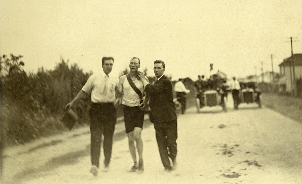
Athletics at the 1904 Summer Olympics – men's marathon - Wikipedia
- Time of past OR future Camino
- 2012
Marvelous!!
- Time of past OR future Camino
- 2024
Exactly, and forget ballpark because the only thing that matter is WHEN are you gonna get that beer - SO that is what Google Maps SatNav does to the very minute but dont seem this gonzo has even heard of itThis post and its replies has been an entirely entertaining read. I'm not aware of any other Camino forum, board, blog or vlog whose members will devote as much energy to topics such as discussing the method for, and pitfalls of, determining the precise accuracy of distance measured between stages and published by another website. I mean it sincerely; I don't mean to be sarcastic. I always learn something new out of these esoteric discussions.
With regard to the topic, I just want a ballpark* figure to know how much further before I can relax and enjoy an ice cold caña. "it's not far now" as a response by anyone around me is an entirely acceptable measure of distance in my book. First round is on me! Cheers
*Ballpark Figure: An acceptable, roughly accurate approximation, as in "I know you can't tell me the exact cost; just give me a ballpark figure". This term alludes to a baseball field, which is always an enclosed space.

St James' Way - Self-guided 4-7 day Walking Packages, Reading to Southampton, 110 kms
- Time of past OR future Camino
- 2024
Thanks for your detailed reply and sorry to have confused you but I too was confused about the actual "issue" in this thread. I am talking about the SatNav that everyone has in their smartphone in Google Maps which I was (apparently wrongly) assuming everyone uses, especially in Car mode. Yes I had a Garmin type device 12 years ago when I was still able to go bushwalking and it was fun to use but the Camino routes are not bushwalking (especially Frances) so are covered by Google in their SatNav.Thank you for this, but I don't know that it really explains whether you are using the term 'SatNav' in some unusual way. You seem to use it to refer to a variety of GIS products, some of which I wouldn't consider to be satellite navigation products per se. Google Earth is one of those, and it is touching to see such faith being expressed in its accuracy. As a Garmin user, I can think of similar Garmin mapping products that I would use in preference to Google Earth, and I am sure that there are many others that offer similar or better quality results.
I also think that your statement that a recorded file (I presume you mean a track, in this context) is going to be shorter than one that 'perfectly "smooths" out the corners' is the wrong way around. There is only one circumstance where it will be shorter, and that is where the recorded track is consistently inside the line of a curve. I don't think this is would apply to much of the camino.
I am not sure what product you have in mind that is using AI to generate track information. While I haven't looked in detail, it seems most of the mapping and navigation apps rely on the mathematics of spherical geometry, and its practical application in navigation or surveying on the less than perfect sphere we live on. That clearly isn't AI, so I am wondering what it is you are referring to here.
In relation to the current discussion, I am of much the same view as @dick bird. We could engage in an unending search for greater and greater levels of accuracy but have little real, practical, impact on pilgrims. We will become like the Galician majones with km distances presented to the third decimal place when you could add much more than a metre when you next get off the route to get a coffee.
You simply need to enter your destination for the day (and normally a few intermediate ones along the way) and press START and the nice Google Lady tells you to turn left in 50 m etc (and tells you off if you take a wrong turn) but the best part in my view is that when you pushed START it added the time for Ms Average Walker to complete the walk and tells you the expected arrival time at the bottom of the screen. Then the further you walk the better it "learns" YOUR actual walking habits and adjusts the arrival time accordingly, and ditto when you stop for coffee.
So I was confused as to why people were complaining about "wrong distances" in this gonzo app thing, assuming (makes an ass of you and me) if it purported to be a guide it would surely give a link to the SatNav for the route.
I will get back to your other matters in due course (pun intended).
- Time of past OR future Camino
- 2012, 2015, 2018, 2019, 2022, 2024
So you can follow the Camino on Google Maps? I didn´t know that.the Camino routes are not bushwalking (especially Frances) so are covered by Google in their SatNav.
- Time of past OR future Camino
- 2024
Exactly right and although not a Dan Brown reader I have watched several docos about how the Leonardo Da Vinci painting shows Mary Magdalene (not John) on the right of Jesus with a V between them (and no cup). Hence the plot for the bookI think the quest for the Grail is more likely to produce a finite result.
But as I progress down this Camino (on the screen) I am seeing Lat Supper sculptures where Mary has her head snuggled up to Jesus and the V between her and the next apostle.
Then at the next church we have Mary with a huge cabinet full of gold chalices and another church which belonged to the Knights Templar.
For sure there is heaps of Holy Grail stuff going on around these parts

The focus is on reducing the risk of failure through being well prepared. 2nd ed.
- Time of past OR future Camino
- 2024
Here is an example for Walk 18So you can follow the Camino on Google Maps? I didn´t know that.
- Time of past OR future Camino
- 2024
here is the Grail Cabinet and still looking for last supperExactly right and although not a Dan Brown reader I have watched several docos about how the Leonardo Da Vinci painting shows Mary Magdalene (not John) on the right of Jesus with a V between them (and no cup). Hence the plot for the book
But as I progress down this Camino (on the screen) I am seeing Lat Supper sculptures where Mary has her head snuggled up to Jesus and the V between her and the next apostle.
Then at the next church we have Mary with a huge cabinet full of gold chalices and another church which belonged to the Knights Templar.
For sure there is heaps of Holy Grail stuff going on around these parts

- Time of past OR future Camino
- Past: a few
Last: Sanabres
Next: St Olav's Way
That seems a relatively simple example. I tried the approach you outlined in three places with more complicated topography: leaving Lisbon, leaving Ferrol, and arriving in Santiago from O Areal. These are sections with which I am familiar. After some fiddling with intermediate waypoints, I got the Ferrol track in Google Maps about right, and I think I could have done much the same for the route leaving Lisbon. But Google Maps wasn't able to find anything like the Camino route leaving A Picarana, just after O Areal, despite extensive fiddling with intermediate waypoints. Somehow, the underlying mapping data that would allow that is missing.Here is an example for Walk 18
There was no route that I tried that gave a good result just with a daily start and end point. If I didn't use an existing gps track in OSMAnd, so I wouldn't count that against Google Maps . While I haven't tried it enough to be definitive, my conclusion is that Google Maps is no better at route planning than other mapping products that I have used, and doesn't have all the same capabilities as many of them. What it does do well is search for places of interest such as cafes, bars, shops, hotels, etc, etc, provided one is prepared to stay online, and I have used that often enough both on the Camino and in daily life.

€2,-/day will present your project to thousands of visitors each day. All interested in the Camino de Santiago.
- Time of past OR future Camino
- 2012, 2015, 2018, 2019, 2022, 2024
I am going to say this before anyone else does - one could always follow the yellow arrows.
- Time of past OR future Camino
- Too many and too often!
Which were first painted by Don Elias Valiña and his associates in 1984 - forty years ago this year. An anniversary worth noting I think. The Casa de Galicia in Madrid is hosting an exhibition about Don Elias just now. I carried his guidebook for my first two Caminos. One of the few regrets I have about my first Camino was that I arrived in O Cebreiro just a few months too late to meet him.I am going to say this before anyone else does - one could always follow the yellow arrows.
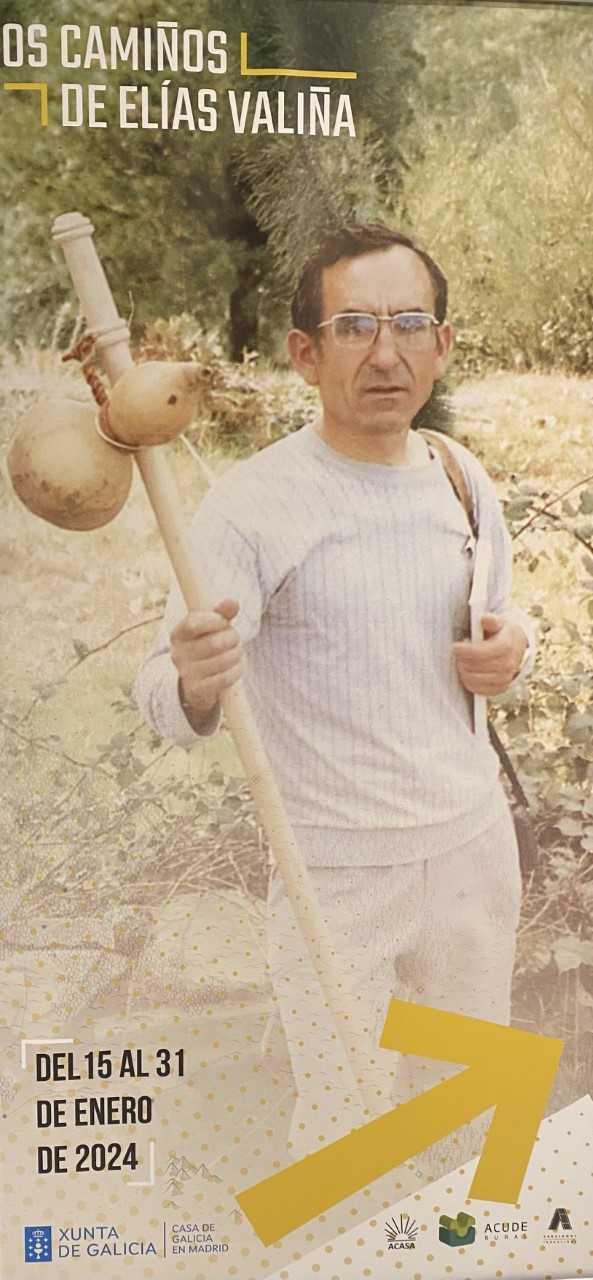
A Casa de Galicia en Madrid acolle a presentación e exposición sobre a figura de Elías Valiña, creador das frechas amarelas do Camiño de Santiago
A Casa de Galicia en Madrid acolle a presentación e exposición sobre a figura de Elías Valiña, creador das frechas amarelas do Camiño de Santiago

Last edited:
- Time of past OR future Camino
- Us:Camino Frances, 2015 Me:Catalan/Aragonese, 2019
here is the Grail Cabinet and still looking for last supper
I am going to say this before anyone else does - one could always follow the yellow arrows.
Say guys, I'm trying to follow the French Way using both apps and binoculars. It's not working. Pokemon's keep blocking the view.
The one from Galicia (the round) and the one from Castilla & Leon. Individually numbered and made by the same people that make the ones you see on your walk.
- Time of past OR future Camino
- Ingles fr. Ferrol 8/2024
And speaking of distances -- it seemed to me that the Milestone distances are also a bit less than accurate, both between them and to Santiago.
jflorez
Joe Florez
- Time of past OR future Camino
- Camino Frances: May/Jun (2018), Sept/Oct (2021)
Oh no, you had to open that can of worms. And down the rabbit hole we go in, 3, 2, 1..And speaking of distances -- it seemed to me that the Milestone distances are also a bit less than accurate, both between them and to Santiago.

- Time of past OR future Camino
- 2024
Absolutely goddam right - for every one of my Web-Apps (about 200 at present) I attach the wordsI am going to say this before anyone else does - one could always follow the yellow arrows.
"The Waymarkers on the Path (if any) should always be relied upon with Sat Nav used only in the context of a "helper"."
The operative word is "if" and that was the plot element in The Way that Daniel could not find any waymarkers (and his guide was "not worth much" as it was American and not Dutch) - so he died. Alas poor Daniel, as his dad said "the only person I know that does not use a smartphone".
The focus is on reducing the risk of failure through being well prepared. 2nd ed.
- Time of past OR future Camino
- Too many and too often!
Alas poor Daniel, as his dad said "the only person I know that does not use a smartphone".
The bridge where Daniel's dad drops his rucksack into the river then swims after it is about 15km away from the Camino Frances. Seems his dad didn't know how to use one either.....
- Time of past OR future Camino
- 2024
So what is the name of that bridge please (or general location). Another important aspect is the speed of change of technology (hardware and software) and The Way was made in 2010 or so when the smart phone itself was in its infancy so we see Boomer at the golf course at start of movie with a plain vanilla mobile phone and the stupid term "app" became the word of the year after that time (from memory) so in fact Daniel and dad would not have had access to the things available nowThe bridge where Daniel's dad drops his rucksack into the river then swims after it is about 15km away from the Camino Frances. Seems his dad didn't know how to use one either.....
- Time of past OR future Camino
- Us:Camino Frances, 2015 Me:Catalan/Aragonese, 2019
So what is the name of that bridge please (or general location).
From post
Scene at the bridge 42°47'14.8"N 1°21'56.1"W over the río Irati near Aoiz, just below the Itoiz reservoir, whose floodgates were opened specially for the shooting of this scene. 0:41:52 - 0:44:07 (off Camino Francés). The bridge seems to have been renovated since 2009 -- there is now no pole sticking up at the breakwater seen at 0:41:59 - 0:42:02, 0:42:08 - 0:42:22 and 0:42:23 - 0:42:28.
42°47'14.8"N 1°21'56.1"W
Technical backpack for day trips with backpack cover and internal compartment for the hydration bladder. Ideal daypack for excursions where we need a medium capacity backpack. The back with Air Flow System creates large air channels that will keep our back as cool as possible.
€83,-
€83,-
JabbaPapa
"True Pilgrim"
- Time of past OR future Camino
- 100 characters or fewer : see signature details
Most given distances are slightly incorrect, the fundamental reasons being not just inevitable human error, but more generally the ongoing and continuing changes in the routes of the various Camino Ways.
The current mostly accurate numbers I'm aware of are the new waymarker distances on the Francès in Galicia and the more westerly sections of it in Castilia y León, but even there, walking in the Winter of 2022 I saw one location where a new Camino route was being installed evading a new road junction and lengthening the route there by several hundred metres. A few of such changes on any Camino route can lengthen or shorten it by several K.
The current mostly accurate numbers I'm aware of are the new waymarker distances on the Francès in Galicia and the more westerly sections of it in Castilia y León, but even there, walking in the Winter of 2022 I saw one location where a new Camino route was being installed evading a new road junction and lengthening the route there by several hundred metres. A few of such changes on any Camino route can lengthen or shorten it by several K.
- Time of past OR future Camino
- 2024
Agreed and that is why Google Maps SatNav is so superior to other methods of navigation, ie a huge team of "Google Local Guides" on the ground using the "road fix" facility to keep everything updated, all being checked by the latest satellite data.Most given distances are slightly incorrect, the fundamental reasons being not just inevitable human error, but more generally the ongoing and continuing changes in the routes of the various Camino Ways.
The current mostly accurate numbers I'm aware of are the new waymarker distances on the Francès in Galicia and the more westerly sections of it in Castilia y León, but even there, walking in the Winter of 2022 I saw one location where a new Camino route was being installed evading a new road junction and lengthening the route there by several hundred metres. A few of such changes on any Camino route can lengthen or shorten it by several K.
- Time of past OR future Camino
- 2012, 2015, 2018, 2019, 2022, 2024
Forgive my ignorance, but do they check footpaths as well? I suspect most people who walk the camino are not much interested in pinpoint accuracy and will forgive minor discrepancies in distance. The camino is not that difficult to find anyway (Emilio Estevez took enormous artistic liberties with the plot of ´The Way´). Navigation is not their main concern. Much more important is where to stay and find refreshment. This is why they rely far more on sources such as Gronze, Wise Pilgrim when they are actually walking the camino rather than Google Maps."road fix"
€2,-/day will present your project to thousands of visitors each day. All interested in the Camino de Santiago.
- Time of past OR future Camino
- Past: a few
Last: Sanabres
Next: St Olav's Way
I am am unlikely to be the only one to suggest that we use other apps because we don't find Google Maps as superior as you suggest. Nor is it the only product supported by crowd-sourced mapping information keeping it up to date. More, I don't think the underlying geo-spatial information is as good as that contained in Open Street Maps when it comes to walking routes such as the Camino, and I have already provided an example of that. While I do use it for some specific tasks where it does have advantages, it's not my preferred navigation tool for the Camino.Agreed and that is why Google Maps SatNav is so superior to other methods of navigation, ie a huge team of "Google Local Guides" on the ground using the "road fix" facility to keep everything updated, all being checked by the latest satellite data.
- Time of past OR future Camino
- Too many and too often!
I walked my first Camino twenty years before the film was released. Digital mobile phones and the world wide web were still in development and neither would reach the public until the following year. But I made it from SJPDP to Santiago with only a few small deviations by following the yellow arrows and the maps in my guidebook. I am a fan of modern technology in general, an early adopter of both personal computers and the internet, and I wouldn't choose to walk without my smartphone these days but I know it can be done. Some situations do require pinpoint accuracy but probably not walking a Camino. That's one setting where "close enough" will do for me. And I am fairly sure that Tom found that bridge through artistic licence rather than incompetent navigation!so in fact Daniel and dad would not have had access to the things available now
- Time of past OR future Camino
- 2024
Well the good part about Camino paths is they are Google friendly so all road/path links tend to be "active" which is the Google term to say it supports SatNav in Google Maps (and My Maps), but yes the greater number of fixes discussed at the Local Guide forum are for paths. I am presently just over half distance in documenting the Camino Frances and have not needed to bother Google once, which is not the normal situation.Forgive my ignorance, but do they check footpaths as well? I suspect most people who walk the camino are not much interested in pinpoint accuracy and will forgive minor discrepancies in distance. The camino is not that difficult to find anyway (Emilio Estevez took enormous artistic liberties with the plot of ´The Way´). Navigation is not their main concern. Much more important is where to stay and find refreshment. This is why they rely far more on sources such as Gronze, Wise Pilgrim when they are actually walking the camino rather than Google Maps.

Get a spanish phone number with Airalo. eSim, so no physical SIM card. Easy to use app to add more funds if needed.
- Time of past OR future Camino
- 2024
By "Daniel and dad" I was referring to the real life Emilio and Marty father and son but I don't want to get off topic so is there a thread more devoted to The Way where those matters can be discussed? I tried the search but it didn't seem to find anything.I walked my first Camino twenty years before the film was released. Digital mobile phones and the world wide web were still in development and neither would reach the public until the following year. But I made it from SJPDP to Santiago with only a few small deviations by following the yellow arrows and the maps in my guidebook. I am a fan of modern technology in general, an early adopter of both personal computers and the internet, and I wouldn't choose to walk without my smartphone these days but I know it can be done. Some situations do require pinpoint accuracy but probably not walking a Camino. That's one setting where "close enough" will do for me. And I am fairly sure that Tom found that bridge through artistic licence rather than incompetent navigation!
- Time of past OR future Camino
- Too many and too often!
Lots of them. But why not start your own? Must have been nearly a week since the last one....is there a thread more devoted to The Way where those matters can be discussed? I tried the search but it didn't seem to find anything
- Time of past OR future Camino
- 2024
Sorry about the delay doug but I have now done a web-app for O Areal to Santiago and it DOES track (at least for the base file I used) so please check it out as it explains many aspects of the Google processThat seems a relatively simple example. I tried the approach you outlined in three places with more complicated topography: leaving Lisbon, leaving Ferrol, and arriving in Santiago from O Areal. These are sections with which I am familiar. After some fiddling with intermediate waypoints, I got the Ferrol track in Google Maps about right, and I think I could have done much the same for the route leaving Lisbon. But Google Maps wasn't able to find anything like the Camino route leaving A Picarana, just after O Areal, despite extensive fiddling with intermediate waypoints. Somehow, the underlying mapping data that would allow that is missing.
There was no route that I tried that gave a good result just with a daily start and end point. If I didn't use an existing gps track in OSMAnd, so I wouldn't count that against Google Maps . While I haven't tried it enough to be definitive, my conclusion is that Google Maps is no better at route planning than other mapping products that I have used, and doesn't have all the same capabilities as many of them. What it does do well is search for places of interest such as cafes, bars, shops, hotels, etc, etc, provided one is prepared to stay online, and I have used that often enough both on the Camino and in daily life.

Technical backpack for day trips with backpack cover and internal compartment for the hydration bladder. Ideal daypack for excursions where we need a medium capacity backpack. The back with Air Flow System creates large air channels that will keep our back as cool as possible.
€83,-
€83,-
- Time of past OR future Camino
- Past: a few
Last: Sanabres
Next: St Olav's Way
Camo, parts of it seem to be a cycling alignment, other parts appear to be part of an older alignment that I have walked, but which isn't waymarked any more, and other parts seem to be either a cycling alignment or an alternative route that walkers might use, but isn't the only route once one gets into the suburbs south of SDC.Sorry about the delay doug but I have now done a web-app for O Areal to Santiago and it DOES track (at least for the base file I used) so please check it out as it explains many aspects of the Google process
I don't know how you fix this. If this was a route suggested by Google Maps, I already know this section proved difficult, and Google wasn't able to find the walking route I used (along with most other walking pilgrims) after O Areal.
- Time of past OR future Camino
- 2024
Doug sorry to hear YOUR yellow arrow path did not translate to SatNav for you but it is dead simple using MY yellow arrow track.Camo, parts of it seem to be a cycling alignment, other parts appear to be part of an older alignment that I have walked, but which isn't waymarked any more, and other parts seem to be either a cycling alignment or an alternative route that walkers might use, but isn't the only route once one gets into the suburbs south of SDC.
I don't know how you fix this. If this was a route suggested by Google Maps, I already know this section proved difficult, and Google wasn't able to find the walking route I used (along with most other walking pilgrims) after O Areal.
Open my track
Then starting at location 2 (and working to location 9) simply drag any pin on my track that is not on your track TO a point on your track. All done!
Save your new track for others to use if you wish
- Time of past OR future Camino
- Past: a few
Last: Sanabres
Next: St Olav's Way
Not going to happen, and for one simple reason. Google cannot generate a track that follows the Camino route from O Areal to SDC.Save your new track for others to use if you wish
I said earlier that I suspect that Google does not make available the underlying GIS data that would be needed to make the route calculations needed. The most compelling evidence of this is that no matter where I place a new waypoint at the start of the walking track through the forest area to the NE of Parque Empresarial da Picaraña, the displayed route continues to follow the N-550 for almost a kilometre. I have walked around and through Picaraña both times I walked the CP, and the N-550 is a busy road and not suitable for roadside walking in the absence of a dedicated pedestrian path. A pilgrim would have to be crazy to follow the path Google suggests.Then starting at location 2 (and working to location 9) simply drag any pin on my track that is not on your track TO a point on your track. All done!
As an experiment, I tested the section from where I stayed in O Areal and the Praza do Obradorio in Mapy.cz installed on an Android smartphone. It not only picked up the forest path at Picaraña, with just a start point at O Areal, and end point in Praza do Obradoiro and no intermediate shaping points, it correctly identified a complete solution that actually followed one of the waymarked alternatives that I have walked. Anyone wanting to choose other alternatives would need to add some additional shaping points, but clearly not as many as you have chosen to use.
None of this gives me any confidence that Google Maps should be trusted when it comes to Camino navigation. Mind you, most routes that I have followed generally have sufficient way-marking as it is, and that there is normally little need for gps assistance. I just need to be more diligent about looking out for the arrows!

New Original Camino Gear Designed Especially with The Modern Peregrino In Mind!
- Time of past OR future Camino
- 2024
Thanks again doug, you have now given us a single clue about the directions for your favourite route from O Areal to Santiago Cathedral so I can now do the drag for you and in 10 seconds we haveNot going to happen, and for one simple reason. Google cannot generate a track that follows the Camino route from O Areal to SDC.
I said earlier that I suspect that Google does not make available the underlying GIS data that would be needed to make the route calculations needed. The most compelling evidence of this is that no matter where I place a new waypoint at the start of the walking track through the forest area to the NE of Parque Empresarial da Picaraña, the displayed route continues to follow the N-550 for almost a kilometre. I have walked around and through Picaraña both times I walked the CP, and the N-550 is a busy road and not suitable for roadside walking in the absence of a dedicated pedestrian path. A pilgrim would have to be crazy to follow the path Google suggests.
As an experiment, I tested the section from where I stayed in O Areal and the Praza do Obradorio in Mapy.cz installed on an Android smartphone. It not only picked up the forest path at Picaraña, with just a start point at O Areal, and end point in Praza do Obradoiro and no intermediate shaping points, it correctly identified a complete solution that actually followed one of the waymarked alternatives that I have walked. Anyone wanting to choose other alternatives would need to add some additional shaping points, but clearly not as many as you have chosen to use.
None of this gives me any confidence that Google Maps should be trusted when it comes to Camino navigation. Mind you, most routes that I have followed generally have sufficient way-marking as it is, and that there is normally little need for gps assistance. I just need to be more diligent about looking out for the arrows!
SatNav
If you go to "details" you will see at Step 9 of 74 the Concello de Teo Bus Stop where we walk across the road to the small continuation track on the other side where in 2018 someone? has painted a yellow strip. This 10 m is the only time you take on the N-550 traffic, and if you want to supply any more points on your favourite track I can do the same for you.
But just to repeat that the original route with 750 m on the busy N-550 was NOT mine or Google's choice but
because you did not supply any details I grabbed a route from the Peregrina 2000 post of "official" Camino files "KML tracks of all caminos - Instituto Nacional Geográfico" and she said:
"This link takes you to a site with a long list and from there you can get to individual camino tracks. My friend says to open it on Google Earth and it will show you stage by stage. All of this is outside my range of abilities, since I use only GPX tracks, but for those who use KML it looks like it should be an excellent resource."
And yes it HAS been an excellent resourse for me to use in Google Earth and Google MyMaps (both on laptop versions of course) so if you have a safety issue I would suggest you contact the ING and send your route for consideration.
In fact your route IS the default route on Google Maps SatNav which is not looking for Camino routes but simply the quickest route A to B.
But to step back a bit there never was a question about "if it works" but I was just asking if Pilgrims USE it, ie not in its default mode but "bent" to follow Camino waypoints. I was wondering if there were other reasons eg like auberges don't have powerpoints but nobody has come up with anything like that, so it remains a mystery (to me) why Pilgrims don't tend to use it.
- Time of past OR future Camino
- Past: a few
Last: Sanabres
Next: St Olav's Way
Which isn't the Camino route between O Areal and Faramello.Thanks again doug, you have now given us a single clue about the directions for your favourite route from O Areal to Santiago Cathedral so I can now do the drag for you and in 10 seconds we have
SatNav
Here are two screenshots of the Camino route from O Areal:


The first is a Google Earth rendering of the .kml track from CNI. The second is from Garmin Basemap. The same track has been converted to a route, and the path calculated using the 'walking' routing setting and any shaping points on the N-550 removed.
I don't think there is much more value in this discussion. Until you can show that Google Maps can calculate this path for a walker, I will remain unconvinced about its utility as a Camino navigation app. Even if you can, I wouldn't be recommending it to anyone walking the Camino. There are far better general mapping tools and specialist camino apps that I will continue to suggest to pilgrims wanting that form of assistance.
- Time of past OR future Camino
- 2024
Maybe it would be easier to answer your question if you gave some specific examples of stages so we can compare Gronze to the actual satellite measurement, including the ups and downsIs it me or are a lot of stages a bit longer in reality than mentioned on Gronze? It seems like you often need to add 1 or 2 kms.

3rd Edition. More content, training & pack guides avoid common mistakes, bed bugs etc
- Time of past OR future Camino
- 2024
Let me make it clear I am NOT looking for any "recommendations" as my work is all "hobby mode" - I was merely wondering if Camino pilgrims in general were using Google SatNav for walking same as they (and most of the world) does in a car?Which isn't the Camino route between O Areal and Faramello.
Here are two screenshots of the Camino route from O Areal:
View attachment 163592
View attachment 163593
The first is a Google Earth rendering of the .kml track from CNI. The second is from Garmin Basemap. The same track has been converted to a route, and the path calculated using the 'walking' routing setting and any shaping points on the N-550 removed.
I don't think there is much more value in this discussion. Until you can show that Google Maps can calculate this path for a walker, I will remain unconvinced about its utility as a Camino navigation app. Even if you can, I wouldn't be recommending it to anyone walking the Camino. There are far better general mapping tools and specialist camino apps that I will continue to suggest to pilgrims wanting that form of assistance.
But putting that aside I have now convinced Google that your 2018 diversion near O Areal IS part of the track as marked by waymarkers (even if NOT on any map files). So you or anyone can now use it.
As for Camino Frances I am now up to walk 25 and have only needed to work with Google on about 30 fixes, so in a month or so the WHOLE track will be active


Most read last week in this forum
Everyone talks about the wonderful café con leche, but what if tea is more to your liking? Can you even get tea along the Camino (Frances)? I don’t drink coffee but my morning cup of tea is...
Hey all.
I haven't been on the forum for quite sometime (years probably).
I walked the Camino Frances in 2016 and to say it was life changing for me is an understatement. On day 3, at the café at...
When you stop at a bar for a beer, wine, coffee or bite to eat, and sit at a table, is it expected that you will return your dirty dishes up to the bar before you leave? I alway do, as it seems...
I am just back from a few weeks on the Via the la Plata. Since 2015 I have been nearly every year in Spain walking caminoroutes I loved the café con leches. This year I did not like them as much...
Let me preface this by saying please understand I am not picking on anybody, I fully understand that mistakes happen and how. Been there, done that.
I have been astonished to see so many lost...
Hi!
I just want to know if anyone had any success (or trouble conversely on that matter) using your Visa Debit Card with 6-digit PIN when withdrawing Euros in ATMs in France and Spain? Just want...
Similar threads
- Replies
- 53
- Views
- 3K
- Replies
- 17
- Views
- 2K
❓How to ask a question
How to post a new question on the Camino Forum.
Similar threads
-
 When Posting Reviews on Gronze . . .
- Started by Anniesantiago
- Replies: 53
-
 Are mosquitos seasonal on the Camino?
- Started by Peregrinopaul
- Replies: 28
-
Gronze Maps app in the Apple Store
- Started by Joan Fiol (Gronze.com)
- Replies: 17
-
 Trends in 2023 - Gronze article
- Started by Bradypus
- Replies: 40
-
 Are there Book swaps on the Camino. What book would you take.
- Started by Bedspring
- Replies: 36
Forum Rules

Camino Updates on YouTube

Most downloaded Resources
-
 “All” Albergues on the Camino Frances in one pdf“All” Albergues on the Camino Frances in one pdf
- ivar
- Updated:
-
 A selection of favorite albergues on the Camino FrancésFavorite Albergues along the Camino Frances
- Ton van Tilburg
- Updated:
-
 Profile maps of all 34 stages of the Camino FrancesProfile maps of all 34 stages of the Camino Frances
- ivar
- Updated: